

The wildfire danger for the Grande Prairie Forest Area is VERY HIGH.
When the fire danger is VERY HIGH fires will spread and increase in intensity quickly. Small fires can become large fires fast and exhibit extreme fire intensity, such as long-distance spotting.
Wildfire Situation | June 4, 2023 9:30 pm
Since January 1, there have been 37 wildfires in the Grande Prairie Forest Area (GPFA) burning nearly 29,000 hectares.
In the past 24 hours there have been three new wildfire starts. Please call 310-FIRE to report a wildfire.
GWF035 was detected this afternoon and is located 20km north of Valhalla Center near the South East side of Boones lake, this wildfire is estimated to be 17.0 hectares in size and is classified as Being Held (BH).
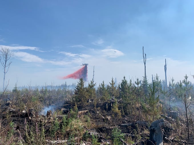
Firefighters with a helicopter bucketing, heavy equipment building dozer and Air tanker dropping retardant were deployed to help build containment lines and stop the spread.
Visit our Wildfire Dashboard to view active wildfires and their stats on the wildfire dashboard.
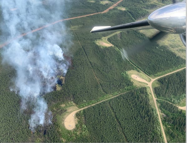
(GWF035 06/04/2023 - 20km north of Valhalla Center)
GWF018
This wildfire is currently classified as out of control (OC). It is now estimated to be 48,200 ha in size. The wildfire experienced increased activity on the north and east flank earlier this week and grew by approximately 800 ha. Fire retardant was laid along areas of the wildfire yesterday and increased dozer guard was established along the fire's north point. Air operations are bucketing water on identified hotspots and crews are being deployed to directly action hot spots. For more information about this fire please visit the Peace River Forest Area Update.
GWF027- Eagle Complex WCX001
This wildfire is classified as out of control (OC) and is now part of the Eagle Complex which is being managed by the Whitecourt Forest Area. For the most recent updates visit the Whitecourt Forest Area Update.
GWF017 & GWF023, GWF019 - Sturgeon Lake Complex GCX001
The Sturgeon Lake Complex is made up of three fires and the total area involved is 28,802 hectares.
With warm and windy weather, an increase of smoke from interior areas of the wildfires and along the perimeter may become more visible. Helicopters with buckets will action these areas and firefighters will continue to extinguish ground fires.
The interior of active wildfires can flare up as previously unburnt vegetation catches fire. This is a normal occurrence. Firefighters are monitoring these active fires and working to put out hot spots. There is no need to report flame or smoke in these areas.
As of June 1, 2023 @1500hrs the status of the wildfires within the Sturgeon Lake Complex has been updated to under control. Under control means that suppression efforts have ensured the wildfire will not spread any further. Firefighters remain on alert for new wildfires and continue to monitor those under control.
GWF017 is estimated to be 5,752 hectares in size and classified as under control (UC).
GWF023 is estimated to be 3,869 hectares in size and classified as under control (UC).
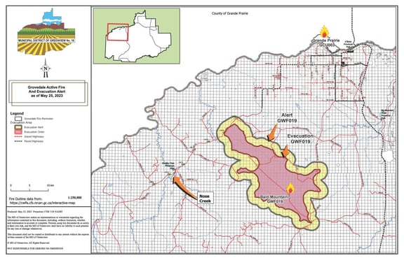
GWF019 - Bald Mountain Fire is 19,435 hectares in size and classified as being held (BH). This fire is approximately 17 km west of Highway 40.
Today there will be 84 firefighting personnel and support staff on site. Two helicopters and nine pieces of heavy machinery are assigned to these fires. Crews will continue to extinguish the perimeter to 100 feet and extinguish all hotspots that are a threat to new and existing containment lines. The team will continue to work toward 100% control of this fire and focus on any potential areas of unburnt fuel.
Unauthorized people are not permitted in or near an active fire perimeter, as displayed on this map below.
Smoke from wildfires burning in north eastern British Columbia is drifting south east into our forest area today. Expect smoke in the air for the next couple of days as multiple wildfires are burning within Alberta, Saskatchewan and British Columbia.
Anyone with health concerns should visit Alberta Health Services or call 811 for health advice from Alberta Health Link. Visit www.firesmoke.ca to see where the smoke is coming from.
Find wildfire forecasts, weather maps and information about how fire danger is monitored in Alberta https://www.alberta.ca/fire-weather-and-forecasts.aspx
A FIRE RESTRICTION is now in effect. Report wildfires by calling 310-FIRE (3473).
Under this FIRE RESTRICTION:
- The Grande Prairie Forest Area will not be issuing fire permits
Prohibited:
- All outdoor wood fires in backcountry and random camping areas on public land
- Charcoal briquettes in backcountry and random camping areas on public land
- The use of fireworks and exploding targets
Allowed:
- Wood campfires on private land and in designated campgrounds
- Charcoal briquettes on private land and in designated campgrounds
- Propane/natural gas-powered appliances
- Open flame oil devices (e.g., turkey deep fryers, tiki torches)
- Indoor wood fires contained within a device with a chimney and spark arrestor
- All appliances must be CSA approved and used per manufacturer’s standards
Please visit albertafirebans.ca to view a map of the impacted area. This fire restriction will remain in effect until conditions improve across the province.
.png?width=659&height=371&name=wildfire%20app%20(2).png)

FIRE PERMITS
A fire restriction is in effect. Anyone living outside the FPA can contact their municipality for information about local fire permit requirements.
From March 1st until October 31st, fire permits are required for any burning except campfires in the Forest Protection Area (FPA).
-
County West / Grovedale - (780) 814-1648
-
Spirit River – (780) 814-1983
-
Valleyview – (780) 524-6576
AIRCRAFT NEAR WATER
Depending on the location of a wildfire, firefighting aircraft may need to use water from nearby lakes as a source of water to help fight wildfires. Often, these aircraft arrive without advanced warning. If you are in the water and see an aircraft coming in to collect water, please move within 30 m from the shore so these aircraft can safely resume firefighting efforts. Aircraft are large and require space to collect water, without interference from people and boats. Help us by staying out of the way when aircraft are around. Click here to learn more.


Kelly Burke | Wildfire Information Officer
(780) 832 7235
Phone: 1-866-394-3473