

For today, temperatures are expected to be 15-16 degrees and relative humidity will be 70-100 percent. The winds will be from the east/southeast gusting up to 45 kilometers per hour. There is a moderate chance of lightning today.
The use of recreational drones over wildfires in Alberta is dangerous, illegal and could result in a fine of up to $15,000* for putting aircraft and people at risk. Please give Alberta firefighters the space they need to do their jobs safely.
*according to Transport Canada
NOTAM
Aircraft pilots are reminded to check NOTAMs before flying into areas with active wildfires. Flying into a NOTAM area without prior authorization will cause disruption to aerial firefighting.
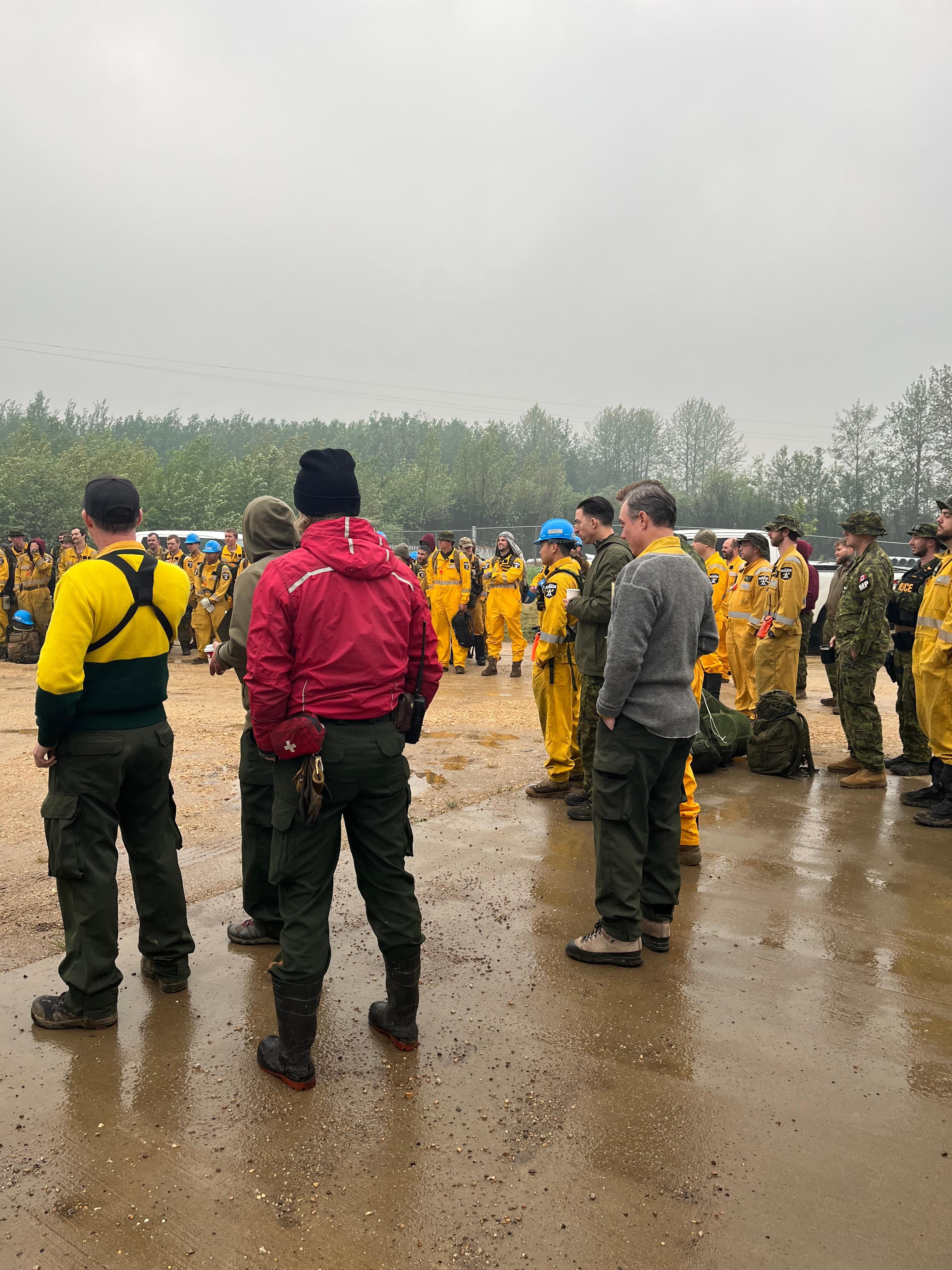
Firefighters and Military Personnel receiving safety briefing this morning before heading out on the fireline.
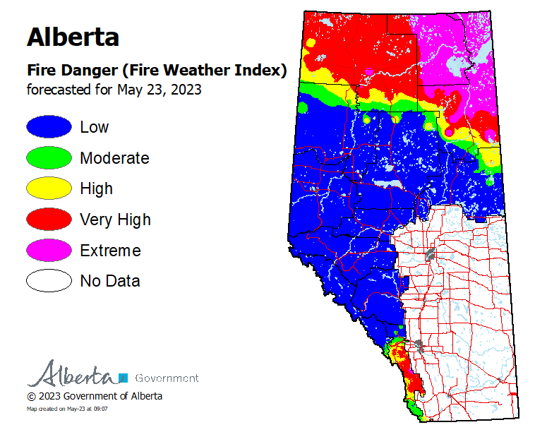
Wildfire Situation
To view wildfires on a map, download the AB Wildfire App or visit the Alberta Wildfire Status Dashboard
NOTE: The wildfire perimeter is an estimate based on measurements such as GPS, aerial scanning and satellite imagery. This estimated perimeter can change as more accurate measurements become available. Areas within the fire perimeter may not have been affected by wildfire.
A provincial state of emergency has been declared for Alberta. Critical alerts and advisories have been and could be issued for communities around active wildfires. Visit http://www.alberta.ca/emergencyalert for details. Albertans who require assistance can also call 310-4455 for evacuation related information.
In the Slave Lake Forest Area there are seven wildfires classified as burning out of control. The wildfires have been receiving rain and are not experiencing any significant growth.
SWF081 located at Chipewyan Lakes is classified as burning out of control. The wildfire is currently estimated to be 19,499 hectares in size. Heavy equipment continues to build fire guard south of the community and the local fire department is working in the community. Wildland firefighters will be setting up a tent camp near the community. For today 46 firefighters and one heavy equipment group will be working on this wildfire. An evacuation order remains in effect for Chipewyan Lakes and surrounding area. Visit https://www.alberta.ca/alberta-emergency-alert.aspx
Saulteaux Complex – SWF085, SWF086 and SWF087
These wildfires are located approximately five kilometres northwest of Smith and 30 kilometres east of the Town of Slave Lake. The wildfires are classified as burning out of control and the estimated wildfire sizes are as follows; SWF085 is 39.4 hectares, SWF086 is 4,802 hectares and SWF087 is 1,500 hectares.
Smoldering ground fire can be seen all the way around the wildfire perimeter. Structure Protection Crews have established equipment to protect homes on the north side of the wildfire and along the Old Smith Highway. Heavy equipment continues to build fire guard on the north side of the wildfires and firefighters are working to extinguish hotspots along the east side of the wildfire perimeter.
There is a total of 100 firefighters and 24 support staff assisting 14 pieces of heavy equipment on the Nipisi and Saulteaux Complexes. 16 helicopters are conducting bucketing operations visibility will allow them too. 88 military personnel will be helping with transportation, safety, and various firefighting duties.
Message for homeowners in wildfire areas
We ask that residents stay out of areas that have been burned by the wildfires in the area. Wildfires will make the root systems of trees weak, and any amount of wind will affect the trees in the area. Falling trees will be an ongoing hazard and for residents’ safety you should avoid the burned-out areas.
Firefighters will be actively working on and around property’s extinguishing hotspots, please give them the space they need to work.
There will be structure protection equipment on homes and infrastructure in the area. We ask that you do not move the equipment as it is in place to protect buildings on your property. Structure protection will remain in place until the wildfire threat has decreased.
For information on the Nipisi and Saulteaux Complex please call the Wildfire Information Officer - Colby Lachance at 780-404-9186.
Message from MD of Lesser Slave River:
The evacuation order has been lifted and replaced with a eight hour evacuation warning for the MD of Lesser Slave River for all residents along Old Smith Highway from Township Road 715 (Smith Bridge) to Range Road 45 (Tollenaars Bridge). An eight hour evacuation warning has been issued for all residents in Hondo, the hamlet of Smith, and all properties between. It also includes the Fawcett Lake Resort, Broken Paddle and all residents between Fawcett Lake and Smith bridge on township road 715. Mitsue Industrial Park area is also on an eight hour evacuation notice. Visit for information https://www.alberta.ca/alberta-emergency-alert.aspx
Highway 2 is open. For the latest road conditions visit https://511.alberta.ca/#:Alerts
SW060 has combined with SW059 and is located 2.3 kilometres east of the border of the Whitefish Lake First Nation is classified as burning out of control and has burned approximately 43,981 hectares. The southwest end of the wildfire closest to the Whitefish Lake First Nation Community border continues to hold and a sprinkler line has been established north of the community. Firefighters are working on the south, north and northwest ends of the wildfire extinguishing hotspots along the perimeter.
SWF083 is located on the east side of Muskwa Lake. Airtankers have established retardant lines around the entire wildfire. The wildfire is classified as being held at 33.7 hectares. Being held means under the current weather conditions, the wildfire is not anticipated to grow past expected boundaries.
For information on the Nipisi and Saulteaux Complex please call the Wildfire Information Officer - Colby Lachance at 780-404-9186.
Cool temperatures and rain has reduced the fire behavior on all these wildfires.
SWF-057 is located approximately 26 kilometres south of Kinuso and over 30 kilometers southwest of the Town of Slave Lake, is classified as out of control and has burned an estimated 16,728 hectares. Firefighters continue to extinguish hotspots along Highway 33 and the perimeter of the wildfire.
SWF-063 is located approximately seven kilometers south of High Prairie, and sixteen kilometers northwest of Swan Hills, is classified as burning out of control and has burned an estimated 123,670 hectares. In the northwestern portion of the wildfire, firefighters continue to extinguish hotspots in the Banana Belt and East Prairie Metis Settlement areas. Heavy equipment continues to build fire guards around the edge of wildfire excursions. East Prairie Metis Settlement and Town of Swan Hills are under an evacuation order. Visit https://www.alberta.ca/alberta-emergency-alert.aspx
SWF-064 is located over 40 kilometers northwest of Swan Hills, is classified as out of control and has burned approximately 40,060 hectares. There was insufficient visibility to do an aerial assessment of this fire yesterday, but no significant growth was expected. This wildfire has connected to SWF-063 to the north.. One heavy equipment group is working on this wildfire.
There are 13 helicopters (including 2 heavy machines), five groups of heavy equipment and 77 firefighters working on the Grizzly Complex.
SWF068 located approximately six kilometres northwest of Peavine Metis Settlement. Firefighting operations are being conducted by the Peace River Forest Area. Peavine Metis Settlement remains under an evacuation order. Visit https://www.alberta.ca/alberta-emergency-alert.aspx For more information on this wildfire visit the Peace River Wildfire Update.
Since January 1, 2023, in the Slave Lake Forest Area, there have been 86 wildfires which have burned 361,952.72 hectares.
Since January 1, 2023, in the Forest Protection Area of Alberta, there have been 520 wildfires which burned 1,017,636.27 hectares.
To view wildfires on a map, download the AB Wildfire App or visit the Alberta Wildfire Status Dashboard
A provincial state of emergency has been declared for Alberta. Critical alerts and advisories have been and could be issued for communities around active wildfires. Visit http://www.alberta.ca/emergencyalert for details. Albertans who require assistance can also call 310-4455 for evacuation related information.
Learn about wildfires and what you can do to be prepared. Visit https://www.alberta.ca/wildfire-preparedness.aspx
With the dynamic wildfire situation, highways could be closed with short notice. Visit https://511.alberta.ca for the latest information on road closures.
For your safety, travel on side roads around active wildfires is not recommended. Not only are there active fires in these areas there are also firefighting operations that could be delayed by your presence. Firefighters appreciate your cooperation.
Due to the numerous wildfires in Alberta, smoky conditions with falling ash will persist in communities and along highways. Anyone with health concerns should visit Alberta Health Services or call 811 for health advice from Alberta Health Link. Before travelling check www.511.Alberta.ca for information the latest road conditions or closures. Visit www.firesmoke.ca to see where the smoke is coming from and to view wildfires on a map, download the AB Wildfire App or visit the Alberta Wildfire Status Dashboard.
We have firefighters in aircraft working on the out of control wildfires and fire lookouts watching for smoke. While we always appreciate people calling in to report wildfires, the large volume of calls we are currently receiving is diverting our resources away from fighting wildfires. As always, please still call 310-FIRE if you see smoke or flame that looks new and potentially unreported, but assume that large columns of smoke and burned over areas have already been detected and reported.
Volunteers, equipment owners/operators or firefighters looking to assist with these wildfires or any of the wildfires within the province, please contact EmergencySupportOffers@gov.ab.ca.

FIRE BAN AND OHV RESTRICTION IN EFFECT
A fire ban and off-highway vehicle restriction is in effect within the Forest Protection Area due to extreme fire danger.
Under this fire ban:
-
All existing Fire Permits are suspended (or cancelled)
-
No new Fire Permits will be issued
Prohibited:
-
All outdoor wood fires are banned, including wood campfires on public lands, wood campfires on private land and provincial campgrounds
-
Backyard firepits
-
BBQ charcoal briquettes
-
The use of fireworks and exploding targets
-
The recreational use of off-highway vehicles (OHV) on public lands, including designated OHV trails
Allowed:
-
Propane/natural gas-powered appliances
-
Open flame oil devices (e.g., turkey deep fryers, tiki torches)
-
Indoor wood fires contained within a device with a chimney and spark arrestor
-
All appliances must be CSA approved and used per manufacturer’s standards
-
Indigenous people when using an off-highway vehicle for traditional purposes. Traditional purposes are hunting, fishing, and trapping – including the use of an OHV to travel to the location(s) for these purposes.
-
Essential industry-related activities requiring the use of OHVs.
-
Off-highway vehicle use is still permitted on private lands.
The fire ban and ohv restriction will remain in effect until conditions improve. Firefighters thank you for your cooperation.
To view a map of the affected area visit www.albertafirebans.ca
If you have questions about the Fire Ban or OHV Restriction please call 1-866-394-3473.
.png?width=1200&name=wildfire%20app%20(2).png)
The wildfire dashboard provides up-to-date wildfire information at the click of a button. This interactive tool displays important statistics on the number of active wildfires in the province, sizes, locations, suspected causes and more. The dashboard builds on the former wildfire status map by displaying the most frequently accessed information in one convenient location.
Download the Alberta Wildfire app today and get access to accurate, real-time information on wildfires in your area. You can also find information on fire advisories, restrictions and bans across the province and much more all on your mobile device. Available for Apple and Android.
Subscribe to the Slave Lake Forest Area Wildfire Update to receive an email when new information is posted.
Join the conversation on Facebook, Twitter or Instagram. ![]()
![]()
![]()
Unless conditions change you can expect your next wildfire update on May 24, 2023.
If you have any questions please contact:
Leah Lovequist
Wildfire Information Officer
Mobile:780-849-0945
Email:leah.lovequist@gov.ab.ca
RELATED INFORMATION
Websites: