

The wildfire danger for the Grande Prairie Forest Area is EXTREME
Hot temperatures and shifting wind conditions in our area will continue to raise the wildfire danger and fire behaviour over the coming days. Daytime highs near 30 degrees Celsius combined with overnight lows near 14 degrees Celsius are expected through Monday with shifting winds at NW 10-15 at times gusting to 20 km/h.
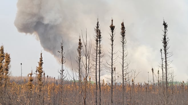
Expect local smoke, multiple wildfires continue to burn out of control. Anyone with health concerns should visit Alberta Health Services or call 811 for health advise from Alberta Health Link. To learn more about smoke visit firesmoke.ca
(GWF-027 May 14, 2023 7 p.m.)
Wildfire Situation | May 13, 2023
No new wildfires were detected today in the Grande Prairie Forest Area. Since January 1, 2023, there have been 27 wildfires in the Grande Prairie Forest Area. At this time, nearly 17,189 hectares (ha) have burned. Of these fires, four are listed as out of control (OC), six are under control, one is being held, two have been turned over to the responsible party for extinguishment and 14 of these fires have been extinguished.
To see all wildfires on a map please click here.
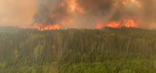
GWF027 - is classified as out of control (OC) and estimated to be 5,500ha. This fire is located 27 km SW of Little Smoky and continues to show very aggressive fire behaviour. This wildfire is an active crown fire burning in continuous spruce and pine fuel type. Today, our suppression resources were pulled off this wildfire by noon due to safety.
Bald Mountain Fire - GWF 019 is located 21km west of Hwy 40, 50 km South of Grande Prairie. This fire is classified as out of control (OC) and estimated to be 11,750ha in size. Today, we worked the fire with air support. Heavy equipment and crews have been mobilized and preparing to work on areas of highest priorities closest to communities. Suppression efforts have been challenged due to fire behaviour.
Sturgeon Lake Complex GCX-001 – (GWF017) (GWF023)
An Incident Management Team from Quebec assumed command of the Sturgeon Lake Complex Friday afternoon. The complex has two fires. GWF017 is estimated to be 3765 hectares in size and considered out of control. GWF023 is estimated to be 1,189 hectares in size and considered out of control. GWF017 is located on both sides of Highway 43 and borders the entire east side of Sturgeon Lake. GWF023 is located to the north of GWF017 and to the west of Highway 49. Municipal structural protection along with the Sturgeon Lake Cree Nation is assisting in fighting these wildfires.
Today there were 49 firefighting personnel and 74 management and support staff on site. 50 additional firefighters from the United States arrived this afternoon and will be integrated into operations tomorrow morning. 25 pieces of heavy equipment were allotted to the two fires. On GWF017, crews continued extinguishing hotspots within the communities of Sandy Bay and Sturgeon Lake. Work consisted of creating containment lines of 100 feet along the perimeter of the fire in priority areas. On GWF023, crews worked with structural protection units in an effort to protect the various values at risk. This afternoon, ground crews were unable to directly attack the fire as fire behaviour became extreme. Heavy machinery was used to construct dozer guard around the areas of new expansion, whenever possible. Helibucketing was also used to action hot spots. Due to heavy smoke and low visibility, the use of airtankers was not possible. The predicted hot and dry weather conditions caused aggressive fire behaviour this afternoon. Both fires have grown. New sizes and perimeters will be made available once visibility and fire behaviour allow crews to safely map the area.
For any questions on this complex please contact the Incident Management Information Officer at 819-441-7006.
For Greenview Emergency Operations Centre check here
GWF018 - This wildfire is located on both sides of the Peace River and yesterday it grew by approximately 2,500 ha yesterday. This wildfire is impacting Hwy 64. Highway 64 is closed in both directions from Range Road 74 to Range Road 91.
There is an evacuation alert for the County of Clear Hills as GWF018 continues to be very active. For more information about this evacuation alert, visit https://clearhillscounty.ab.ca/ Check Peace River forest Area for more information.
The Dunes West Wildfire - The Canadian Military, Alberta Wildfire with USA resources continue to assist the County of Grande Prairie with a mutual aid wildfire in the dunes area 8 km southeast of Dimsdale. For information call the Dunes West Wildfire Information line at 1-825-606-5092.
info@gprepeoc.com and for updates check GPREP here.

Alberta Emergency Alert has issued evacuation notices for:
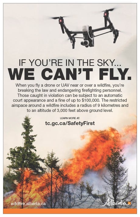
The use of recreational drones over wildfires in Alberta is dangerous, illegal and could result in a fine of up to $15,000* for putting aircraft and people at risk. Please give Alberta firefighters the space they need to do their jobs safely.
*Transport Canada
Kelly Burke | Wildfire Information Officer
(780) 832 7235
Phone: 1-866-394-3473
- Alberta Wildfire
- Alberta Fire Bans
- FireSmart in Alberta
- Alberta Emergency Alerts
- Air Quality Health Index
- Wildfire Smoke and Your Health
- 511 Road Reports
- Emergency Preparation

 Please subscribe to the Grande Prairie Forest Area wildfire update to receive an email when new information is posted.