

The wildfire danger for the Grande Prairie Forest Area is EXTREME
Hot, dry conditions will persist through weekend leading to critically dry fuels. As a result, fires will start easily, be fast-moving, very intense and difficult to catch.
The average forecast across the forest area is a temperature of 27 degrees, a relative humidity of 15 per cent with widespread crossover conditions and winds from the southwest 20 km/h.
Expect local smoke, multiple wildfires continue to burn out of control. Anyone with health concerns should check the Alberta Health Services or call 811 for health advise from Alberta Health Link. To learn more about smoke visit firesmoke.ca
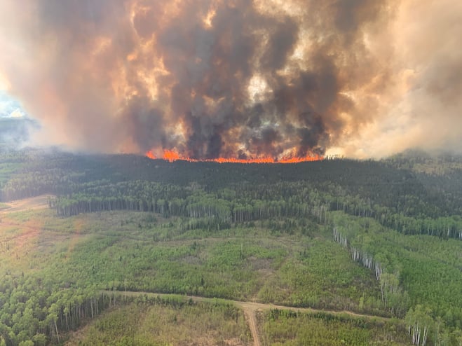
(Bald Mountain Wildfire GWF-019 May 12, 2023)
Wildfire Situation | May 12, 2023
A busy afternoon was had here at the Grande Prairie fire center. Today, two new wildfires were detected both were quickly brought under control. Since January 1, 2023, there have been 26 wildfires in the Grande Prairie Forest Area. At this time, nearly 13,449 hectares have burned. Of these fires, three are listed as out of control (OC), six are under control, one is being held, two have been turned over to the responsible party for extinguishment and 13 of these fires have been extinguished.
To see all wildfires on a map please click here.
Sturgeon Lake Complex GCX-001 – (GWF017) (GWF023)
GWF017 - is classified as out of control (OC) and estimated to be 3,765 ha in size. This wildfire is located on both sides of Highway 43. Municipal structural protection along with Sturgeon Lake Cree Nation is assisting with this wildfire. Heavy equipment continues to build fire guard around both wildfires and firefighters continue to secure the guard by extinguishing the wildfire's perimeter. Dozer guard construction is progressing and nearly complete. Increased fire behaviour will challenge suppression resources and is expected to increase over the weekend with hot dry conditions.
GWF023 - is classified as out of control (OC) is estimated to be 1,189 ha. This area continues to be actioned by helicopters bucketing and firefighters with nod wells working hotspots. Increased fire behaviour yesterday, challenging suppression resources, expected to increase over the weekend with hot dry conditions. No growth has been observed in the past 24 hours. A Quebec incident management team is now in place with an out of province 20 person sustained action crew.
For Greenview Emergency Operations Centre check here
GWF018 - There is an evacuation alert for the County of Clear Hills as GWF018 continues to be very active. This wildfire grew by approximately 500 ha yesterday north of the Peace River, and has crossed a fire guard. It is anticipated this wildfire will move toward Hwy 64, approximately along Range Road 84. For more information about this evacuation alert, visit https://clearhillscounty.ab.ca/ Check Peace River forest Area for more information.
Bald Mountain Fire - GWF 019 is located 21km west of Hwy 40, 50 km South of Grande Prairie. This fire is classified as out of control (OC) and estimated to be 8,362 ha and expected to grow by about 20% tonight. Firefighters continue to monitor this wildfire. Fire behaviour did increase this afternoon and air tankers skimmed water off Musreau lake to drop on the North west flank of this wildfire.
An Alberta Emergency Alert was issued today for this wildfire burning in the area south of Township Road 690, between Highway 40 and the BC Border. Everyone in this area must evacuate now. Everyone north of Township Road 690 to the Wapiti River should be prepared to evacuate on short notice. This fire is expected to grow in the coming days as hot dry weather continues.
The Dunes West Wildfire - We are assisting the County of Grande Prairie with a mutual aid wildfire in the dunes area 8 km southeast of Dimsdale. Resources continue to arrive to aid in containing this out of control (OC) wildfire. The estimated size was mapped at 1,500.00 ha, no growth of this fire has been observed in the past 24 hours. The east perimeter contains numerous hotspots that remain a concern.
Another thermal heat scan will be done tonight, these scans provide information of hotspots that remain. Thermography measures surface temperatures by using infrared video and still cameras. These tools detect light in the heat spectrum. Images on the video record the temperature variations of the ground. Mapping is then produced to guide tactical efforts.
For information call the Dunes West Wildfire Information line at 1-825-606-5092.
info@gprepeoc.com and for updates check GPREP here.
Alberta Emergency Alert has issued evacuation notices for:
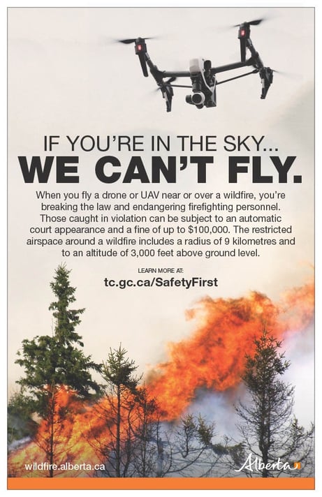
The use of recreational drones over wildfires in Alberta is dangerous, illegal and could result in a fine of up to $15,000* for putting aircraft and people at risk. Please give Alberta firefighters the space they need to do their jobs safely.
*Transport Canada
Kelly Burke | Wildfire Information Officer
(780) 832 7235
Phone: 1-866-394-3473
- Alberta Wildfire
- Alberta Fire Bans
- FireSmart in Alberta
- Alberta Emergency Alerts
- Air Quality Health Index
- Wildfire Smoke and Your Health
- 511 Road Reports
- Emergency Preparation

 Please subscribe to the Grande Prairie Forest Area wildfire update to receive an email when new information is posted.