A fire advisory is now in effect for the Edson Forest Area. Use extra caution when working and recreating and keep watch of your surrounding in case you start a wildfire.
Please ensure you fully extinguish your campfire. Soak it, stir it and soak it again until the ashes are cool to the touch. Never leave your campfire unattended.
If you see smoke or flame in the forest and suspect it's a wildfire, call 310-FIRE.
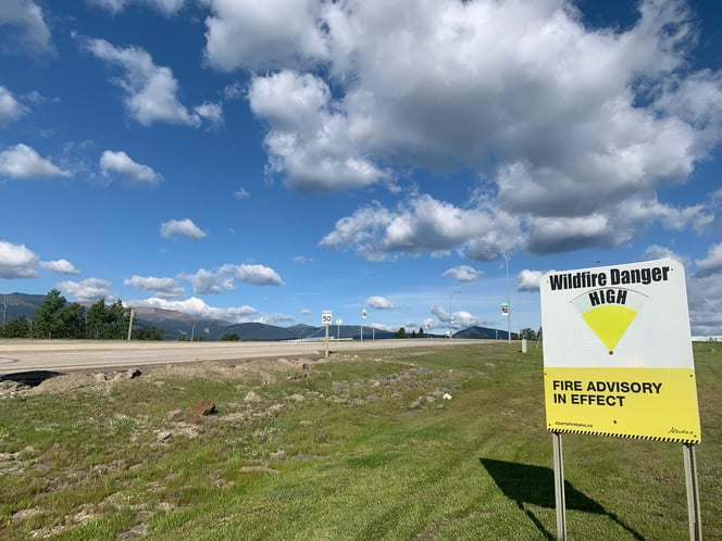
A fire advisory is in effect for the Edson Forest Area due to dry, warm and windy conditions (August 14, 2023).
Bold indicates new or important information.
This update is best viewed on a web browser or the AB Wildfire Status App.
Previous Edson Forest Area Updates - Click here.

A fire advisory is in effect for the Edson Forest Area section of the Forest Protection Area due to warm, dry and windy conditions. Use extreme caution when working and recreating outdoors.
Under this advisory:
- Existing fire permits are still valid but may be suspended or cancelled if dry conditions continue
- Fire permits will still be issued on a case by case basis
Prohibited:
- Any burning without a valid fire permit, other than a campfire, is prohibited
The fire advisory will remain in effect until weather conditions improve.
Stay tuned to www.albertafirebans.ca throughout the wildfire season for more information about fire bans and restrictions in the Forest Protection Area of Alberta.
EDSON FOREST AREA WILDFIRE UPDATE
The wildfire danger in the Edson Forest Area is HIGH. This means that fires can ignite more easily and would have less difficulty spreading to deeper vegetation layers or larger fuels, such as trees. Creeping ground fires could travel but are not expected to burn very quickly. This is due to the the temperatures increasing, the relative humidity decreasing and forecasted strong gusty winds. You can view the provincial wildfire danger map and learn more about how to interpret fire danger by clicking here.
Since January 1, 2023, there have been 79 wildfires in the Edson Forest Area burning a total of 234,558 ha. The last reported wildfire was on August 11. There are currently six active wildfires, all are classified as under control. One is human-caused, four are caused by lightning and one remains under investigation.
Visit our website and click on the interactive map to view active wildfires, their locations and stats on the wildfire dashboard.
PROVINCIAL WILDFIRE UPDATE
Since January 1, 2023 in the Forest Protection Area, there have been 966 wildfires burning a total of 1,840,040 ha. Last year, there were 819 wildfires by this date with a total of 117,684 ha burnt. The 5 year average on this date is 902 wildfires with a total of 202,187 ha burned.
FULLY EXTINGUISH YOUR CAMPFIRE & NEVER LEAVE IT UNATTENDED
If you have a campfire, ensure you place it in an area away from vegetation and out of the wind. It's always best to have your campfire in a metal ring but if that's not possible, place it on bare minimal soil.
Be sure to never leave your campfire unattended and keep a sufficient amount of water nearby in case sparks land in nearby vegetation or your campfire escapes it's ring.
Before you leave, you must soak your campfire, stir the ashes and soak it again until it's cool to the touch. Campfires can burn into the ground and resurface at a later date which could cause a wildfire.
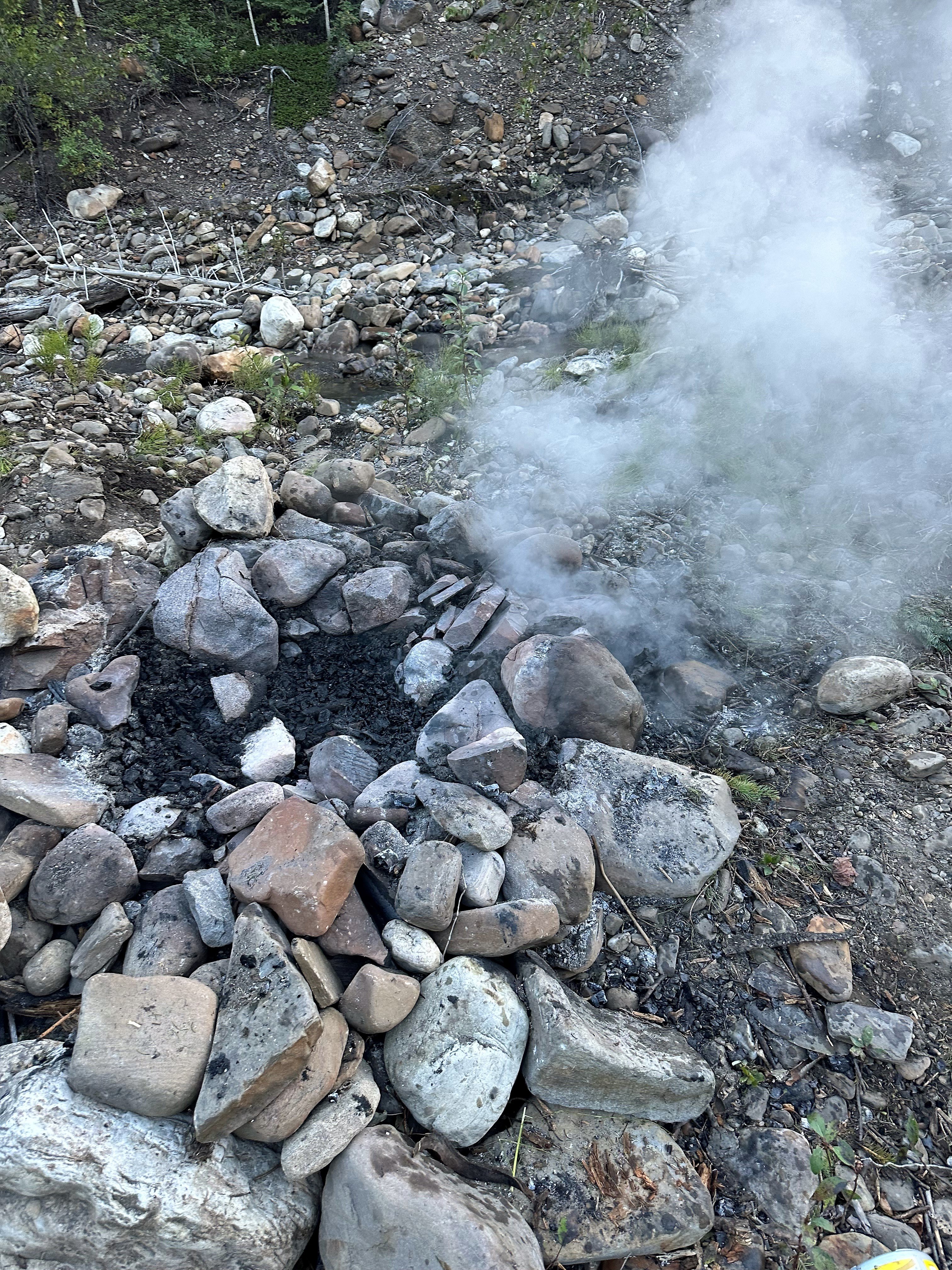
Patrol staff continue to find abandoned campfires on crown land. If these campfires are not properly extinguished, they can re-surface later, wind can carry sparks in nearby vegetation and start a wildfire. Please - take the time to extinguish your campfire (August 2023).
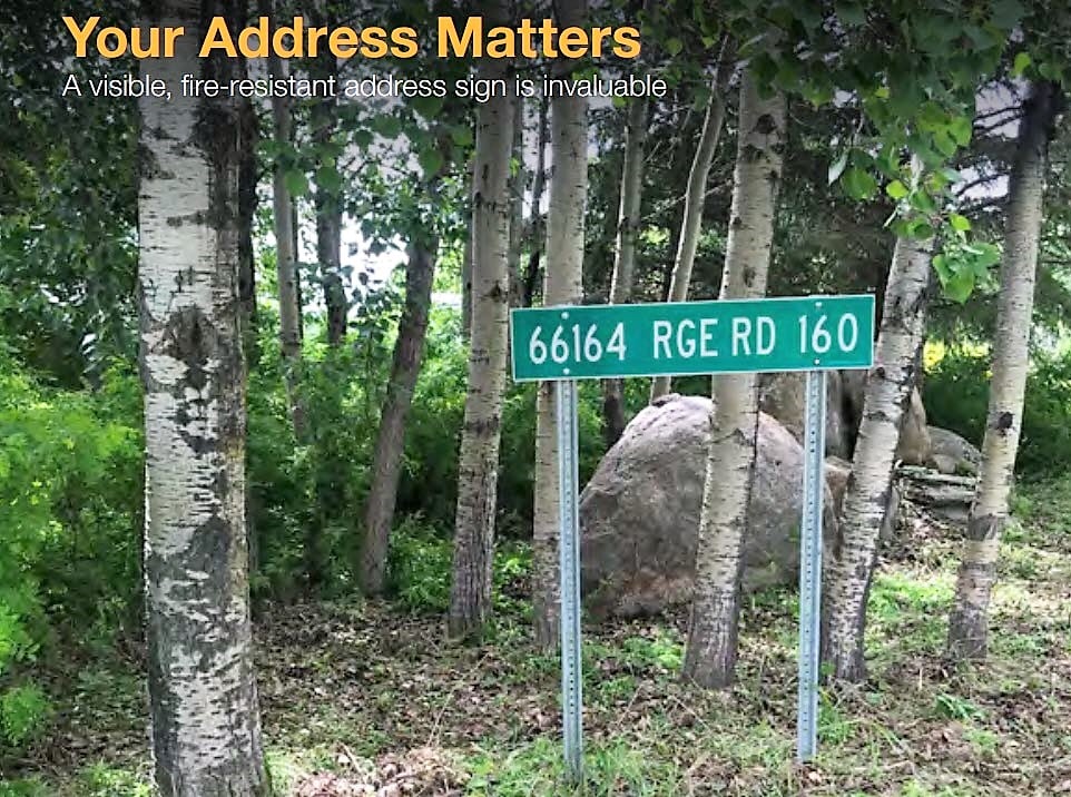
FARM AND ACREAGE | WILDFIRE PREVENTION
Help emergency responders find you faster by ensuring you have a visible, fire-resistant address sign. Imagine a convoy of firefighters rushing down the highway, turning off onto your road and having to look for the driveway next to the crooked tree and beside the big rock! A highly visible, fire-resistant address sign can be your best friend during wildfire season.
Not all counties and municipalities have a rural addressing initiative like the one shown here. If not, you might want to consider having your own address sign made. Use fire-resistant materials, and display it in a visible area near your driveway, away from tall grass and bushes. The posts for the sign also need to be fire resistant! A metal sign on a wooden post isn’t going to help you in a wildfire.
For more information, visit the Farm and Acreage Magazine online by clicking here.
BEFORE YOU BURN IT, GET YOUR FIRE PERMIT
Wildfire season in Alberta is from March 1 until October 31. During wildfire season, you are required to have a fire permit if you plan on burning in the Forest Protection Area, with the exception of a campfire. To request your free fire permit, contact the local forest area: (780) 723-8527 or you can request your permit using the new, convenient online fire permit portal. To view the video, click here.
EDSON FOREST AREA | PEMBINA WILDFIRE COMPLEX | EWF031, EWF039
EWF031 was detected on May 4, estimated to be 201,913 ha in size and determined to be caused by lightning. EWF039 was detected on May 5, is 165 ha in size and determined to be human-caused. Both wildfires are now classified as under control which means that firefighters have this fire fully contained and it is not expected to grow. These wildfires do not pose a threat to any communities or properties, including the Town of Edson. To learn more about wildfire classifications, click here. To view actual locations of the wildfires, visit the wildfire dashboard.
These wildfires will continue to be monitored for activity and be actioned by local firefighting crews when needed. A reclamation plan has begun and equipment have started working on identified areas. This work is anticipated to continue into the winter months.
ROCKY MOUNTAIN HOUSE FOREST AREA | PEMBINA WILDFIRE COMPLEX | RWF034, RWF040
For more information regarding the Rocky Mountain House Forest Area, visit their Wildfire Updates.
EDSON FOREST AREA | DEEP CREEK COMPLEX | WCU001, WCU002, EWF035
WCU001 was detected on April 29, and estimated to be 6,284 ha in size. WCU002 was detected on the evening of April 29 and estimated to be 2,478 ha in size. EWF035 was detected on May 5 and is 19,672 ha in size. All three of these wildfires are classified as under control meaning that the wildfire is completely contained and not expected to grow. None of these wildfires pose a threat to any communities or properties and are in the final stages before they're classified as extinguished. The cause remains under investigation. To view actual locations of the wildfires, visit the wildfire dashboard.
These wildfires are continuously monitored for activity and will be actioned by local wildland firefighting crews if needed. Heavy equipment continue reclamation on these wildfires in areas where the ground is dry enough, removing creek crossings, rolling back disturbed soil and spreading debris for a more natural setting. All disturbed containment lines will need to be reclaimed and this work is expected to continue into the fall and possibly into the winter months.
EDSON FOREST AREA | WILDHAY WILDFIRE COMPLEX | EWF037, EWF040
EWF037 is estimated to be 12,073 ha and EWF040 is estimated to be 578 ha in size. They are both located south of the Little Smoky River, north of the Wild Hay River and east of Hwy 40 north. The complex is 63 km north of Hinton. Both of these wildfires are classified as under control and were determined to be caused by lightning. These wildfires will be monitored by firefighters and actioned as needed.
GENERAL INFORMATION ON WILDFIRES IN OUR AREA
WORK OR RECREATE NEAR WILDFIRE AREAS | We urge residents and members of the public to use extra caution near burnt areas. There are many hazards that may not be visible, like deep burning ash pits and falling trees. Burnt trees are a serious hazard, and trees that may look healthy with green needles or leaves could have burnt out roots under the ground and fall unexpectedly.
UNDERSTANDING WILDFIRE BEHAVIOUR | There are many factors that affect a wildfire and its growth, such as the wind, temperature and the forest fuel moisture conditions. You may have seen the Forestry fire danger signs that are posted around your communities, along highway 16, in Grande Cache on highway 40 and the Edson Forestry warehouse. We set the fire danger based on a number of factors, including the Fire Weather Index (FWI). The FWI is derived from data collected daily at various weather and includes observations of temperature, relative humidity, wind speed, and 24-hour precipitation. The FWI is a system used across Canada to quantify the fire hazard based on forest fuel moisture, temperature, relative humidity and forecasted winds.
Wildfires generally smoulder on and in the ground with very little open flame on low to moderate fire activity days. Creeping surface fire with open flame and the occasional torching tree is typical fire behaviour on moderate days. The days where the fire "picked up" and "took off" were on days when the fire danger was very high to extreme.
UNDERSTANDING WILDFIRE CLASSIFICATIONS | When firefighters classify a wildfire as OUT OF CONTROL, it means that the wildfire is burning and is expected to continue to grow within and possibly outside of its present boundary. The classification of BEING HELD means that under the current weather conditions and the resources available, there will be no unexpected growth, however firefighters anticipate the possibility of a small amount of spread which would be normal on a wildfire of this size. UNDER CONTROL means that the fire is fully contained, firefighters don't except any growth and the next stage would be extinguished. To learn more about wildfire classifications, click here.
Albertans are always asked to use caution when working or recreating in the outdoors:
- Before you burn it, get your fire permit. Fire permits in Alberta.
- Clear debris from hot spots on your off-highway vehicle.
- Ensure your campfire is out - soak it, stir it, soak it again.
- Before you head out this weekend, check out the albertafirebans.ca website or download the app to stay informed.
- For road closure information, please visit 511.alberta.ca
- For information regarding smoke in the area, you can visit firesmoke.ca
- NASA FIRMS Fire Information website is a great resource to give an idea of the location of wildfires in the area, but note that the data is based on interpolation and often can make the wildfire look larger then it actually is.
- To view the provincial wildfire danger map, click here.
.png?width=659&height=345&name=WF_Social-images%20(7).png)
ALBERTA WILDFIRE INFORMATION
- Subscribe to the Edson Forest Area wildfire update to receive an email when new information is posted.
- Download the Alberta Wildfire App for Apple and Android device.
- Join the conversation on Facebook, Twitter or Instagram.
For more information, please contact: