All wildfires within the Pembina Complex are now under control. We want to thank everyone who assisted and to the public and residents for their understanding and support.
If you see smoke or flame in the forest, call 310-FIRE.
Previous Edson Forest Area Updates - Click here
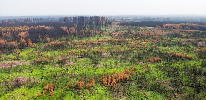 Pretty purple Fireweed is popping up everywhere in freshly burnt areas. These native wildflowers aren't actually weeds, they're one of the first colonizers after a wildfire. (July 20 2023).
**Bold indicates new or important information. This update is best viewed on a web browser or the AB Wildfire Status App.**
EDSON FOREST AREA WILDFIRE UPDATE
The wildfire danger in the Edson Forest Area is LOW. This means that fire can ignite but would have difficulty spreading to deeper vegetation layers or larger fuels, such as trees. Creeping ground fires would not travel very fast as the grass is green and there's sufficient moisture in the fine fuels. You can view the provincial wildfire danger map and learn more about how to interpret fire danger by clicking here.
Since January 1, 2023, there have been 77 wildfires in the Edson Forest Area burning a total of 234,558 ha.
EWF076 was detected on July 24 and is estimated to be 76 ha in size. The wildfire is now classified as being held. There are 40 firefighters and one helicopter assigned to this wildfire.
Visit our website and click on the interactive map to view active wildfires, their locations and stats on the wildfire dashboard.
PROVINCIAL WILDFIRE UPDATE
Since January 1, 2023 in the Forest Protection Area, there have been 915 wildfires burning a total of 1,751,518 ha. Last year, there were 684 wildfires by this date with a total of 117,440 ha burnt. The 5 year average on this date is 777 wildfires with a total of 201,319 ha burned.
FIRE PERMITS
Wildfire season in Alberta is from March 1 until October 31. During wildfire season, you are required to have a fire permit if you plan on burning in the Forest Protection Area, with the exception of a campfire. To request your free fire permit, contact the local forest area: (780) 723-8527 or you can request your permit using the new, convenient online fire permit portal.
EDSON FOREST AREA | PEMBINA WILDFIRE COMPLEX | EWF031, EWF039
EWF031 was detected on May 4 and is estimated to be 201,913 ha in size. It is now classified as under control which means that firefighters have this fire fully contained and it is not expected to grow. To learn more about wildfire classifications, click here. This wildfire was determined to be caused by lightning. To view actual locations of the wildfires, visit the wildfire dashboard.
We want to thank both wildland and structural firefighters, incident management team members, support staff, heavy equipment operators, aircraft personnel, contractors, volunteers and residents for their dedication and hard work.
We are also grateful to their families, friends and those who supported them while they were away from home for long periods of time. We also appreciate the understanding and support from the public and residents. Our communities were excellent hosts to the many national and international firefighters that came to our aide. A special thanks to all the town and municipal partners who worked with us for the past 11 weeks.
This wildfire will continue to be monitored for activity and will be actioned by local firefighting crews when needed. A reclamation plan has begun and equipment has started working on identified areas. This work is anticipated to take months to complete and we expect the work to continue into the winter.
ROCKY MOUNTAIN HOUSE FOREST AREA | PEMBINA WILDFIRE COMPLEX | RWF034, RWF040
For more information regarding the Rocky Mountain House Forest Area, visit their Wildfire Updates.
EDSON FOREST AREA | DEEP CREEK COMPLEX | WCU001, WCU002, EWF035
WCU001 was detected on April 29, and estimated to be 6,284 ha in size. WCU002 was detected on the evening of April 29 and estimated to be 2,478 ha in size. EWF035 was detected on May 5 and is 19,672 ha in size. All three of these wildfires are classified as UNDER CONTROL meaning that the wildfire is completely contained and not expected to grow. None of these wildfires pose a threat to any communities or properties and are in the final stages before they're classified as extinguished. The cause remains under investigation. To view actual locations of the wildfires, visit the wildfire dashboard.
These wildfires are continuously monitored for activity and will be actioned by local wildland firefighting crews if needed. Heavy equipment continue reclamation on these wildfires in areas where the ground is dry enough, removing creek crossings, rolling back disturbed soil and spreading debris for a more natural setting. All disturbed containment lines will need to be reclaimed and this work is expected to continue into the fall and possibly into the winter months.
EDSON FOREST AREA | WILDHAY WILDFIRE COMPLEX | EWF037, EWF040
The Wildhay Complex is comprised of two wildfires. EWF037 is estimated to be 12,073 ha and EWF040 is estimated to be 578 ha in size. They are both located south of the Little Smoky River, north of the Wild Hay River and east of Hwy 40 north. The complex is 63 km north of Hinton. Both of these wildfires are classified as under control and were determined to be caused by lightning. These wildfires will be monitored by firefighters and actioned as needed.
GENERAL INFORMATION ON WILDFIRES IN OUR AREA
WORK OR RECREATE NEAR WILDFIRE AREAS | We urge residents and members of the public to use extra caution near burnt areas. There are many hazards that may not be visible, like deep burning ash pits and falling trees. Burnt trees are a serious hazard, and trees that may look healthy with green needles or leaves could have burnt out roots under the ground and fall unexpectedly. Keep in mind that trees and powerlines could also fall on the road and block your vehicle. Do not approach powerlines as they could be energized.
UNDERSTANDING WILDFIRE BEHAVIOUR | There are many factors that affect a wildfire and its growth, such as the wind, temperature and the forest fuel moisture conditions. You may have seen the Forestry fire danger signs that are posted around your communities, along highway 16, in Grande Cache on highway 40 and the Edson Forestry warehouse. We set the fire danger based on a number of factors, including the Fire Weather Index (FWI). The FWI is derived from data collected daily at various weather and includes observations of temperature, relative humidity, wind speed, and 24-hour precipitation. The FWI is a system used across Canada to quantify the fire hazard based on forest fuel moisture, temperature, relative humidity and forecasted winds.
Wildfires generally smoulder on and in the ground with very little open flame on low to moderate fire activity days. Creeping surface fire with open flame and the occasional torching tree is typical fire behaviour on moderate days. The days where the fire "picked up" and "took off" were on days when the fire danger was very high to extreme.
UNDERSTANDING WILDFIRE CLASSIFICATIONS | When firefighters classify a wildfire as OUT OF CONTROL, it means that the wildfire is burning and is expected to continue to grow within and possibly outside of its present boundary. The classification of BEING HELD means that under the current weather conditions and the resources available, there will be no unexpected growth, however firefighters anticipate the possibility of a small amount of spread which would be normal on a wildfire of this size. UNDER CONTROL means that the fire is fully contained, firefighters don't except any growth and the next stage would be extinguished. To learn more about wildfire classifications, click here.
Albertans are always asked to use caution when working or recreating in the outdoors:
- Before you burn it, get your fire permit. Fire permits in Alberta.
- Clear debris from hot spots on your off-highway vehicle.
- Ensure your campfire is out - soak it, stir it, soak it again.
- Before you head out this weekend, check out the albertafirebans.ca website or download the app to stay informed.
- For road closure information, please visit 511.alberta.ca
- For information regarding smoke in the area, you can visit firesmoke.ca
- NASA FIRMS Fire Information website is a great resource to give an idea of the location of wildfires in the area, but note that the data is based on interpolation and often can make the wildfire look larger then it actually is.
- To view the provincial wildfire danger map, click here.
ALBERTA WILDFIRE INFORMATION
- Subscribe to the Edson Forest Area wildfire update to receive an email when new information is posted.
- Download the Alberta Wildfire App for Apple and Android device.
- Join the conversation on Facebook, Twitter or Instagram.
For more information, please contact: