Join us at RCMP Centennial Park on July 6, 2023 at 5:00 p.m. to meet and greet national and international wildland firefighters with a special demonstration from the South Africans.
As warming and drying conditions continue this week, the public may notice smoke rising from active wildfire areas. If you see smoke or flame that you suspect is not from an active wildfire area, contact 310-FIRE.
Previous Edson Forest Area Updates - Click here
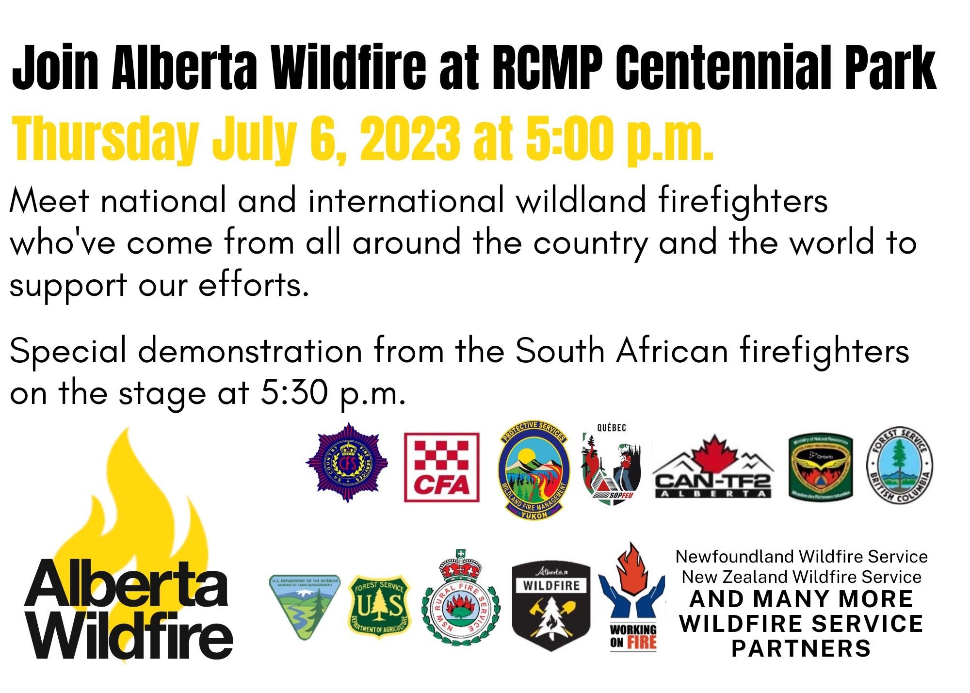
Join AB Wildfire and the many other wildland firefighting partners tomorrow, July 6 at 5:00 p.m. at the RCMP Centennial Park in Edson.
NEW WILDFIRE STARTS
Visit our wildfire dashboard to view active wildfires and their stats.
**Bold indicates new or important information.
UNDERSTANDING WILDFIRE BEHAVIOUR
Alberta Wildfire shares important information with municipal fire departments and community leaders on a daily basis, we work together closely to ensure you are safe in your community. It can be difficult to explain the complexity of these wildfires to the public but we are committed to continue to informing all communities about fire prevention, FireSmart and fire operations when there's a wildfire of significance in our area.
There are many factors that affect a wildfire and its growth, such as the wind, temperature and the forest fuel moisture conditions. You may have seen the Forestry fire danger signs that are posted around your communities, along highway 16 and the Edson Forestry warehouse. We set the fire danger based on a number of factors, including the Fire Weather Index (FWI). The FWI is derived from data collected daily at various weather and includes observations of temperature, relative humidity, wind speed, and 24-hour precipitation. The FWI is a system used across Canada to quantify the fire hazard based on Forest Fuel moisture, temperature, relative humidity and forecasted winds.
Wildfires generally smoulder on and in the ground with very little open flame on low to moderate fire activity days. Creeping surface fire with open flame and the occasional torching tree is typical fire behaviour on moderate days. The days where the fire "picked up" and "took off" were on days when the fire danger was very high to extreme.
Today, the fire danger is MODERATE in our forest area. This means fire can still ignite but is not expected to spread to deeper vegetation layers or larger fuels, such as trees. You can view the provincial wildfire danger map and learn more about how to interpret fire danger by clicking here.
Follow the advice of your community leaders, be prepared and pay attention to the directions that are given. We do not anticipate wildfire growth until the fire danger reaches high or very high.
EDSON FOREST AREA | PEMBINA WILDFIRE COMPLEX | EWF031, EWF039
There are 323 firefighters and 44 support staff working across the Pembina Complex. There are 25 pieces of heavy equipment and eight helicopters assigned to the complex.
The Pembina Complex is continuously being monitored by firefighters to identify priority areas between Edson Forest Area and the Rocky Mountain Forest Area. Due to the perimeter size of this complex and available resources, the containment strategy is based on available resources and weather conditions. Firefighters will keep accessing the fireline where conditions and safety allow.
Firefighters from Australia, New Zealand, South Africa, United States, Alberta, and the Yukon are working together on this fire. An Incident Management Team from Australia is managing the Pembina Complex.
Our highest goals are to protect the public, communities and all critical infrastructure neighboring the entire perimeter of this complex. We are using the downturn in weather to complete targets and plan for future objectives.
Fire Behaviour | Today’s fire danger is low. Decreasing temperatures and increasing relative humidity keep fire behaviour conditions at ease. Very little fire spread predicted in the fine fuels, and any flare ups will be easily knocked down by firefighters. Smoke from hotspots may still be visible within the fire perimeter.
Tomorrow’s forecast is expected to be a high of 24C with 30% relative humidity, with northwesterly winds moving 10-15 km/hr gusting to 30km/hr. Low chance of trace precipitation with potential thunderstorm activity.
EWF031 was detected on May 4 and is located 18 km west of Lodgepole, 5 km northwest of Brazeau Dam and 1.5 km south of Edson. The fire is now classified as wildfire dashboard.
Fickle Lake Area | The burn area is located approximately 2.5 km east of Fickle Lake and approximately 5 km south of Marlboro. Firefighters are continuing to extinguish hotspots found 30 meters within the fires edge.
Willmore Area | The burn area is located approximately 1.5 km south of Edson. Containment line has been established ahead of the most northern edge of this finger to limit any further growth in this area. Crews have extinguished up to 30 meters within edges around the section of fire that crossed the McLeod River.
Active operations to remove damaged tree are occurring in the overflow campground area. We ask the public to please stay out of the area until these operations have completed to keep operators and the public safe. The Town of Edson has not announced when it will be safe for the public to re-enter the park.
Carrot Creek Area | The burn area is located approximately 6 km south of Highway 16 and approximately 10 km southwest of Carrot Creek. Crews are working within Wolf Lake and Minnow Lake areas to assess and fall dangerous trees, cut into firewood, and ensure the area is safe for the public to re-enter. Firefighters continue to look for and extinguish hotspots found along the fires edge in this area.
East Side | The burn area is located approximately 18 km west of Cynthia. Firefighters continue to look for and extinguish hotspots found along the fires edge in this area.
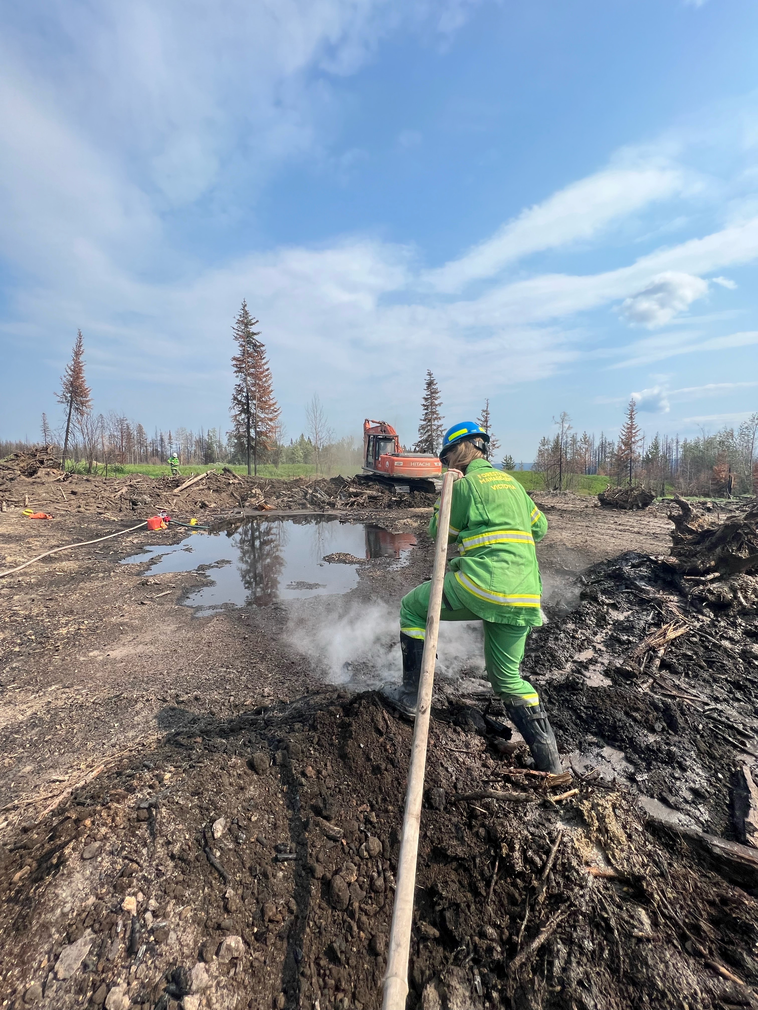 Australian firefighters are working on hotspots on EWF031 (July 4, 2023).
ROCKY MOUNTAIN HOUSE FOERST AREA | PEMBINA WILDFIRE COMPLEX | RWF034, RWF040
RWF034 is located near the O'Chiese Reserve and is classified as being held. The size of the fire is estimated to be 87,492 ha in size.
RWF040 is located near the Blackstone River and Brazeau River is classified as being held. The size of the fire is estimated to be 5,089 ha in size.
Firefighters are working in the southeast section of this fire to extinguish detected hotspots. Resources are being shared with EWF031 and firefighters continue to monitor the ground and weather conditions for changes in fire behaviour. Smoke may still be visible from hotspots within the fire perimeter.
For more information regarding the Rocky Mountain House Forest Area, visit their Wildfire Updates.

By: Tara Stephens, Pembina Wildfire Complex. Wildfire Information Officer. Alberta Forestry and Parks. For information related to the Pembina Wildfire Complex please contact: 780-728-5843.
EDSON FOREST AREA | DEEP CREEK COMPLEX | WCU001, WCU002, EWF035
WCU001 was detected on April 29, and estimated to be 6,284 ha in size. WCU002 was detected on the evening of April 29 and estimated to be 2,478 ha in size. EWF035 was detected on May 5 and is 19,672 ha in size. To view actual locations of the wildfires, visit the wildfire dashboard.
All three of these wildfires are classified as UNDER CONTROL meaning that the wildfire is completely contained and not expected to grow. These wildfires are in their final stages before they're classified as extinguished.
There are 16 firefighters assigned to the Deep Creek Complex. There's also one helicopter, seven pieces of heavy equipment, and three support staff. Additional helicopters and heavy equipment groups are available from the Pembina Complex should they be required on any of the fires within the Deep Creek Complex.
The wildfire complex is expected to see low to moderate fire behaviour in the next couple of days, meaning that very little fire activity will be observed. Residents may see some smoke coming from within the wildfire complex as conditions warm up and fuels dry up. This is expected and AB Wildfire firefighters will monitor and respond to any flare ups as needed.
The Firetack wildfire firefighters were working on a ground fire within WCU001 which was approximately 0.1 ha in size. They responded yesterday and worked on the area all day today. This hot area will be monitored in the coming days for any activity.
Heavy equipment continue reclamation on these wildfires in areas where there is no longer a concern, removing creek crossings, rolling back disturbed soil and spreading debris for a more natural setting. All disturbed containment lines will need to be reclaimed and this work is expected to continue into the fall and possibly into the winter months.
By Caroline Charbonneau, Deep Creek Wildfire Complex. Wildfire Information Officer, Alberta Forestry and Parks, Edson Forest Area. For information related to the Deep Creek Complex please contact: 780-740-1341.
EDSON FOREST AREA | WILDHAY WILDFIRE COMPLEX | EWF037, EWF040
The Wildhay Complex is comprised of two wildfires, EWF037 and EWF040. They are both located south of the Little Smoky River, north of the Wild Hay River and east of Hwy 40 north. The complex is 63 km north of Hinton.
EWF040 is now classified as being held and is estimated to be 12,073 ha.
EWF037 continues to be classified as under control at 578 ha.
GENERAL INFORMATION ON WILDFIRES IN OUR AREA
WORK OR RECREATE NEAR WILDFIRE AREAS | We urge residents and members of the public to use extra caution near burnt areas. There are many hazards that may not be visible, like deep burning ash pits and falling trees. Burnt trees are a serious hazard, and trees that may look healthy that have green needles or leaves could have burnt out roots under the ground and fall unexpectedly. Keep in mind that trees and powerlines could also fall on the road and block your vehicle. Do not approach powerlines as they could be energized.
DRONES | The use of recreational drones over wildfires in Alberta is dangerous, illegal and could result in a fine of up to $15,000* for putting aircraft and people at risk. Please give Alberta firefighters the space they need to do their jobs safely. *Transport Canada
TO SUBSCRIBE TO THE UPDATES | You can subscribe to these updates (or any other forest area's update) and they'll come directly to your email or as a notification on your phone. You can visit our website, enter your email address and click Instant then Subscribe. You can also download the AB Wildfire Status App, click the "i" at the bottom left, click the bell for notifications and toggle the Edson Forest Area Update.
UNDERSTANDING WILDFIRE CLASSIFICATIONS | When firefighters classify a wildfire as OUT OF CONTROL, it means that the wildfire is burning and is expected to continue to grow within and possibly outside of its present boundary. The classification of BEING HELD means that under the current weather conditions and the resources available, there will be no unexpected growth, however firefighters anticipate the possibility of a small amount of spread which would be normal on a wildfire of this size. To learn more about wildfire classifications, click here.
WILDFIRE PREPAREDNESS | Learn how you can prepare yourself for a wildfire by clicking here.
WILDFIRE INVESTIGATIONS | Wildfires in Alberta are either human-caused or caused by lightning. Every wildfire in Alberta is investigated and the wildfires mentioned remain under investigation.
WILDFIRE MAPS AND BOUNDARIES | Note that wildfire perimeter maps are an estimate based on measurements such as GPS, aerial scanning and satellite imagery. This estimated perimeter can change as more accurate measurements become available. Areas within the fire perimeter may not have been affected by wildfire. Visit our Wildfire Dashboard to view active wildfires and their stats on the wildfire dashboard. Click on "view interactive map". You can choose different basemaps by selecting the four squares icon, or layers by clicking on the three sheets of paper on the top right corner.
Albertans are always asked to use caution when working or recreating in the outdoors:
- Before you burn it, get your fire permit. Fire permits in Alberta.
- Clear debris from hot spots on your off-highway vehicle.
- Ensure your campfire is out - soak it, stir it, soak it again.
- Before you head out this weekend, check out the albertafirebans.ca website or download the app to stay informed.
- For road closure information, please visit 511.alberta.ca
- For information regarding smoke in the area, you can visit firesmoke.ca
- NASA FIRMS Fire Information website is a great resource to give an idea of the location of wildfires in the area, but note that the data is based on interpolation and often can make the wildfire look larger then it actually is.
- To view the provincial wildfire danger map, click here.

ALBERTA WILDFIRE INFORMATION
- Subscribe to the Edson Forest Area wildfire update to receive an email when new information is posted.
- Download the Alberta Wildfire App for Apple and Android device.
- Join the conversation on Facebook, Twitter or Instagram.
For more information, please contact: