The Edson Forest Area expects strong gusty winds in the coming days which will make weakened trees fall. We urge residents and members of the public to use extra caution near burnt areas. There are many hazards that may not be visible, like deep burning ash pits and falling trees.
Firefighters continue to build containment lines and extinguish hotspots in key areas near communities.
Previous Edson Forest Area Updates - Click here.
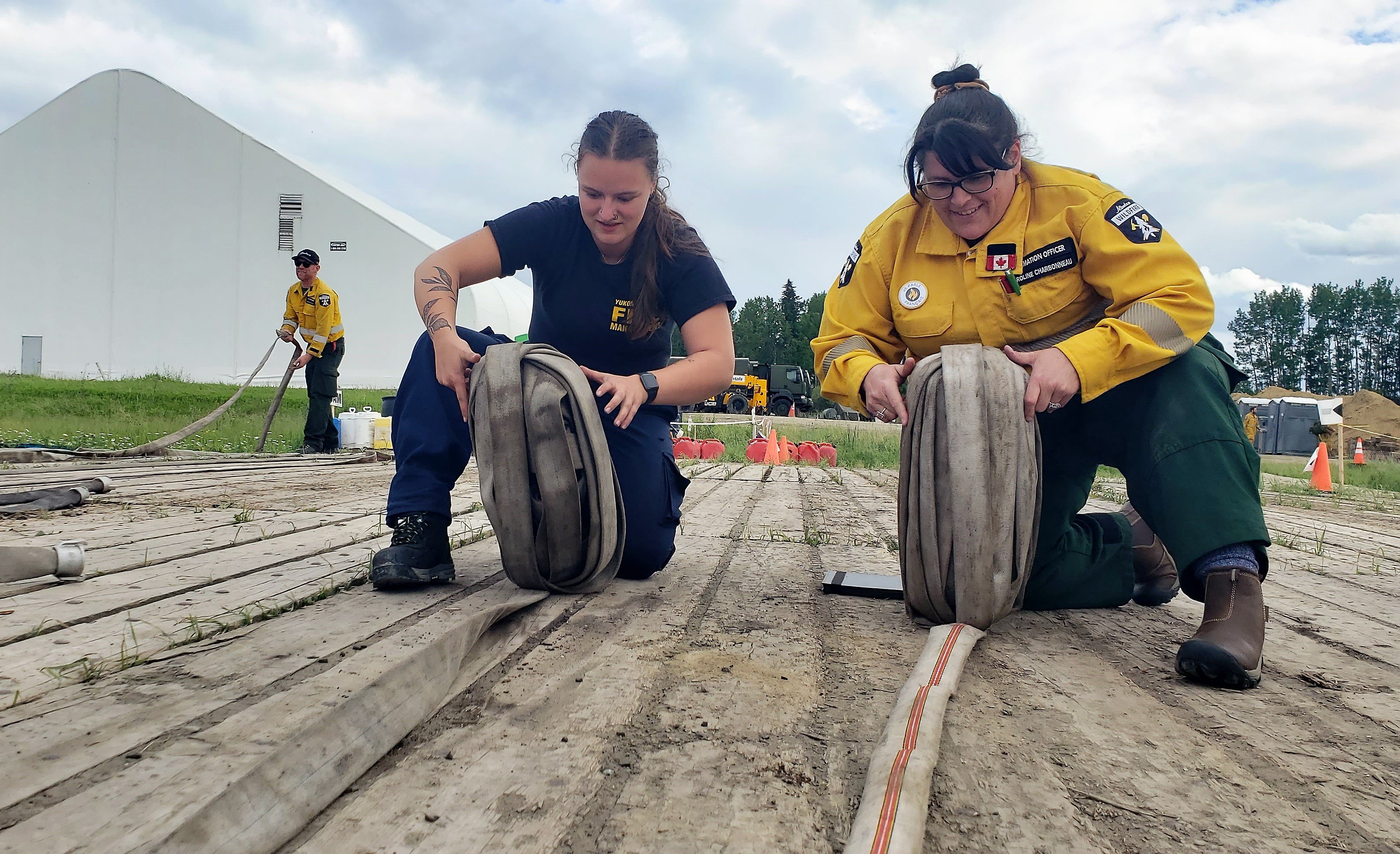 No matter what your position is on the incident, everyone pitches in and helps each other. Alberta, Yukon and Australia were busy rolling melons last night before dinner. This is an easier way for us to package hose to be sent to the warehouse to be cleaned, dried and redeployed on another incident (June 17, 2023).
TO SUBSCRIBE TO THE UPDATES
You can subscribe to these updates (or any other forest area's update) and they'll come directly to your email or as a notification on your phone. You can visit our website, enter your email address and click Instant then Subscribe. You can also download the AB Wildfire Status App, click the "i" at the bottom left, click the bell for notifications and toggle the Edson Forest Area Update.
NEW WILDFIRE STARTS
Visit our wildfire dashboard to view active wildfires and their stats.
UNDERSTANDING WILDFIRE BEHAVIOUR
AB Wildfire shares important information with municipal fire departments and community leaders on a daily basis, we work together closely to ensure you are safe in your community. It can be difficult to explain the complexity of these wildfires to the public but we are committed to continue to informing all communities about fire prevention, FireSmart and fire operations when there's a wildfire of significance in our area.
There are many factors that affect a wildfire and its growth, such as the wind, temperature and the forest fuel moisture conditions. You may have seen the Forestry fire danger signs that are posted around your communities, along highway 16 and the Edson Forestry warehouse. We set the fire danger based on a number of factors, including the Fire Weather Index (FWI). The FWI is derived from data collected daily at various weather and includes observations of temperature, relative humidity, wind speed, and 24-hour precipitation. The FWI is a system used across Canada to quantify the fire hazard based on Forest Fuel moisture, temperature, relative humidity and forecasted winds.
Wildfires generally smoulder on and in the ground with very little open flame on low to moderate fire activity days. Creeping surface fire with open flame and the occasional torching tree is typical fire behaviour on moderate days. The days where the fire "picked up" and "took off" were on days when the fire danger was very high to extreme. Today, the fire danger is low in our forest area and is anticipated to stay low for the next 72 hours. That means that the fire will mostly smoulder in the ground and will have a hard time burning the available fuel on the forest floor. You may still see smoke and even steam from hotspots in the ground. You can view the provincial wildfire danger map and learn more about how to interpret fire danger by clicking here.
In the coming weeks, the fire danger will climb again and the wildfires in our area will become more active. Follow the advice of your community leaders, be prepared and pay attention to the directions that are given. We do not anticipate wildfire growth until the fire danger reaches high or very high.
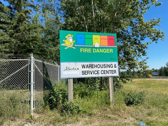 The fire danger sign at the Edson Warehouse (taken on a sunny day) is set to LOW today.
HOW IS EWF031 LOOKING TODAY?
Crews and personnel have been busy supporting operations for the Pembina Complex fires. Aerial resources, like the helicopter shown in the video can be used in many ways. This helicopter was putting out a hotspot that had the potential to spread. Although the video shows a lack of wildfire activity, wildfires can quickly become active again if conditions are hot and dry enough.
Fires often burn inconsistently and leave plenty of unburned fuel behind. This provides an opportunity for firefighters to get close to the perimeter, put out hotspots and reinforce the containment lines.
This video shows EWF031 yesterday which was relatively quiet, the fire danger was low to moderate. In the video you will notice some recognizable features such as the McLeod River, Highway 47 and Carrot Creek Tower (June 18, 2023). **to view this video, open the update in the app or webpage.
EDSON FOREST AREA | PEMBINA WILDFIRE COMPLEX | EWF031, EWF039
**Bold indicates new or important information.
EWF031 was detected on May 4 and is located 18 km west of Lodgepole, 5 km northwest of Brazeau Dam and 1.5 km south of Edson. The fire is classified as out of control and was reassessed and is now estimated to be 205,968 ha in size. Visit our wildfire dashboard to view the perimeter of these wildfires and their stats.
There are 271 firefighters and 65 support staff being shared between the Pembina Complex of fires. There are 72 pieces of heavy equipment, and 19 helicopters assigned to the complex. In addition, structure protection personnel from the Town of Edson and Yellowhead County have integrated with the complex as a structure protection branch to allow for seamless coordination between Alberta Wildfire and the County.
Personnel from Australia, New Zealand, South Africa, United States, Alberta, British Columbia and the Yukon are working together on this fire. An Incident Management Team from Australia is managing the Pembina Complex.
Goals at the Pembina Complex remain first responder and public safety. We are using the downturn in weather to make strong progress on goals and plan for future initial attack.
Fire Behaviour
Since last night, 20-40mm of rain was received on different areas of the fire. Today’s forecast shows north-westerly winds at 15-20 km/hr with gusts up to 40-60 km/hr. Heavy amounts of rain and cooler temperatures are forecasted for the next couple days. With gusty wind conditions, falling trees remain a risk. Little fire spread is forecasted due to mild weather. Hotspots will be cooled and dampened down with subdued smoke.
Wet conditions may impact road access to the fireline, but helicopters will continue to bucket if conditions are safe to do so. Due to inaccessible conditions, crews will remain at the Pembina Complex for a planning, administrative and facilities management day.
Fickle Lake Finger – This area of the fire is approximately 2.5 km east of Fickle Lake and approximately 5 km south of Marlboro.
Personnel are continuing to work closely with structure protection staff from the Yellowhead County to assess and protect values within the Fickle Lake and Marlboro area. Personnel are focusing on assessments triaging, and sprinkler set-up plans. Crews have been patrolling the area to monitor for any hotpots or potential areas of concern. Highway 47 has opened to local traffic only. Personnel and crews have completed a 15km fire guard around excursions that occurred along Highway 47 and the Fickle Lake area.
Willmore Park Finger – This area of the fire is approximately 1.5 km south of Edson.
Machine guard has been established ahead of the most northern edge of this finger to limit any further growth in this area under current conditions. Crews have extinguished up to 100 feet into the fire perimeter around the fire that crossed over the McLeod River. Crews continue to patrol this area to monitor for hotspots.
Carrot Creek Area – This area of the fire is approximately 6 km south of Highway 16 and approximately 10 km southwest of Carrot Creek. Planned controlled burn operations in this area will be revaluated over the coming days when favourable conditions are present. The Carrot Creek lookout tower is now operational. Heavy equipment and personnel are being used to reinforce a dozer guard in the Carrot Creek area. Helicopters were bucketing on hotspots near the Carrot Creek tower yesterday. 1.5km of machine containment line was completed along the Wolf Creek Road.
East side – This area of the fire is approximately 18 km west of Cynthia.
On June 13, increased fire behavior was observed along the east side of the fire, west of Highway 753 and caused approximately 350-hectares of new fire growth to the east, approximately 10 km south of Eta Lake. Aerial resources are responding to hotspots as weather conditions allow. Heavy equipment and personnel continue to build and reinforce dozer guard on the east side of the fire over the next two days. The fire edge remains approximately 18 km to the west of Cynthia.
Australian firefighters are assisting AB Wildfire on the Pembina Wildfire Complex (June 17, 2023).
ROCKY MOUNTAIN HOUSE FOERST AREA | PEMBINA WILDFIRE COMPLEX | RWF034, RWF040
RWF034 is located near the O'Chiese Reserve and classified as out of control. The fire is currently estimated at 87,492 ha in size.
Personnel and heavy equipment are continuing to put out hotspots along the western side of this fire.
Crews will be making use of the cool temperatures and rainfall to continue reinforcing control lines and identifying concerns within the perimeter. Smoke may still be visible despite rainfall. The perimeter on the west side of the Brazeau Reservoir has remained quiet.
RWF040 is being actively monitored by firefighters and support staff assigned to the complex who can respond if necessary. Personnel continue to work on putting out hotspots within the perimeter. The fire is currently estimated to be 5,089 ha in size and remains classified as out of control.
For more information regarding the Rocky Mountain House Forest Area, visit their Wildfire Updates.

By: Emma MacDonald, Pembina Complex. Wildfire Information Officer. Yukon Wildland Fire Management. For information related to the Pembina Wildfire Complex please contact: 780-728-5843. Emma MacDonald and Haley Ritchie are part of the Information Team on the Pembina Complex.
EDSON FOREST AREA | DEEP CREEK COMPLEX | WCU001, WCU002, EWF035
WCU001 was detected on April 29, and is now BEING HELD and estimated to be 6,284 ha in size. WCU002 was detected on the evening of April 29, and is now BEING HELD and estimated to be 2,478 ha in size. EWF035 was detected on May 5, is now classified as BEING HELD and is 19,672 ha in size. To view actual locations of the wildfires, visit the wildfire dashboard.
UNDERSTANDING WILDFIRE CLASSIFICATIONS | When firefighters classify a wildfire as OUT OF CONTROL, it means that the wildfire is burning and is expected to continue to grow within and possibly outside of its present boundary. The classification of BEING HELD means that under the current weather conditions and the resources available, there will be no unexpected growth, however firefighters anticipate the possibility of a small amount of spread.There are 149 firefighters assigned to the Deep Creek Complex, five helicopters, 36 pieces of heavy equipment, and 59 support staff who are part of the incident management team, equipment maintenance and crew supervision (to name a few positions). Additional helicopters and heavy equipment groups are available from the Pembina Complex should they be required on any of the fires within the Deep Creek Complex.
A developing cold front from the west will arrive over weekend giving moderate to heavy precipitation through to Monday. There's a potential for over 50 mm of rain. The wildfire complex also expects moderate northeast winds with gusts reaching 40-50 km/h into Monday.
Our firetack crews are being relieved for some much needed rest and the Working on Fire crews from South Africa will be heading on four days off from Monday to Thursday. AB Wildfire firefighters with the Canadian Military will remain on the line with more firefighters scheduled to arrive in the coming days. They will continue to re-enforce the containment lines, extinguishing hotspots that may threaten the lines.
Some of the heavy equipment may be pulled off the fireline in the coming days and will be sitting in the staging area due to the heavy rain. Roads become unstable and the ground too soft in some places to support heavy equipment.
WCU001 remains fairly quiet. Members of the Canadian Armed Forces are working alongside AB Wildfire firefighters near highway 16 and the train tracks. They're searching for and extinguishing hotspots with water pumps, hose and hand tools. Their goal is to fully extinguish this wildfire. AB Wildfire firefighters will monitor and respond to any flare ups as needed. Residents and the public may see smoke or flame within the perimeter and this is normal as we work our way around and into the fire.
WCU002 also remains fairly quiet thanks to the work from our various firefighters and the cooler, wet weather we're experiencing. Approximately 16 Alberta Wildfire firetack crew members are working near the Lobstick river on the northwest side of the wildfire. Crews will continue to work in key areas, including in peat farms and cattle fields.
EWF035 is showing some flare ups which will continue to occur within the perimeter of the fire until sufficient precipitation falls on the wildfire. These flare ups will be monitored and actioned accordingly by firefighters.
Firefighting crews and heavy equipment were working on the middle section of the western boundary of the wildfire. They have completed building containment line, tying in some of the unburnt areas west of East Bank Road, south of Twp 560. This was to prevent a larger burn from occurring due to the forest fuel types that the wildfire could consume and burn again.
Crews will continue to work along the southwest side of the wildfire, searching for and extinguishing hotspots. Same for the southern portion, east of Rg Rd 131 and west of Rg Rd 130.
Heavy equipment will begin reclamation on these wildfires in areas where there is no longer a concern, removing creek crossings, rolling back disturbed soil and spreading debris for a more natural setting. All disturbed containment lines will need to be reclaimed and this work is expected to continue into the fall and possibly into the winter months.
By Caroline Charbonneau, Deep Creek Complex. Wildfire Information Officer, AB Wildfire - Edson Forest Area. For information related to the Deep Creek Complex please contact: 780-740-1341.
EDSON FOREST AREA | WILD HAY WILDFIRE COMPLEX | EWF037, EWF040
The Wild Hay Complex is comprised of two wildfires, EWF037 and EWF040. They are both located south of the Little Smoky River, north of the Wild Hay River and east of Hwy 40 north. The complex is 63 km north of Hinton. EWF040 is producing a lot of smoke that can be seen from far away, including from Hinton.
EWF040 remains out of control and was estimated to be 12,073 ha. It escaped its wildfire boundary on June 7 and is burning mostly to north-northwest from its original area and has crossed the the Berland River and is now burning in both our forest area and the Whitecourt Forest Area. Today, firefighters anticipate that the cold front will shift the winds sometime this afternoon and push the fire towards the south.
EWF037 continues to be classified as being held at 578 ha.
GENERAL INFORMATION ON WILDFIRES IN OUR AREA
AREA CHALLENGES | This has been an unprecedented wildfire season; one that has resulted in many challenges for wildfire staff across the province. In response Alberta has been working with our partners to meet the demands for personnel and equipment needed to fight the numerous wildfires we have seen this spring. In the Edson Forest Area we currently have crews and support staff from all over Canada and the world, including U.S.A., Australia, New Zealand and South Africa, B.C., P.E.I., Newfoundland and Ontario.
WORK OR RECREATE NEAR WILDFIRE AREAS | We urge residents and members of the public to use extra caution near burnt areas. There are many hazards that may not be visible, like deep burning ash pits and falling trees. Burnt trees are a serious hazard, and trees that may look healthy that have green needles or leaves could have burnt out roots under the ground and fall unexpectedly. Keep in mind that trees and powerlines could also fall on the road and block your vehicle. Do not approach powerlines as they could be energized.
SMOKE | Lingering smoke can still be visible in some areas and in affected communities. Smoke inversions can trap air near the ground causing dangerous driving conditions and impacting nearby communities. If you have smoke related health concerns, please contact Alberta 811 or visit Alberta Health Services . Visit firesmoke.ca for current and forecasted smoke.
REPORTING WILDFIRES | We always appreciate people calling in to report wildfires but the large volume of calls we are receiving could be diverting our resources away from other essential tasks. As always, call 310-FIRE if you see smoke or flame that looks new and potentially unreported, but assume that large columns of smoke and burned over areas have already been detected and reported. If you or your property are in immediate danger, call 911.
AIRCRAFT NEAR WATER | Depending on the location of a wildfire, firefighting aircraft may need to use water from nearby lakes as a source of water to help fight wildfires. Often, these aircraft arrive without advanced warning. If you are in the water and see an aircraft coming in to collect water, please move within 30 m from the shore so these aircraft can safely resume firefighting efforts. Aircraft are large and require space to collect water, without interference from people and boats. Help us by staying out of the way when aircraft are around. Click here to learn more.
DRONES | The use of recreational drones over wildfires in Alberta is dangerous, illegal and could result in a fine of up to $15,000* for putting aircraft and people at risk. Please give Alberta firefighters the space they need to do their jobs safely. *Transport Canada
WILDFIRE PREPARDNESS | Learn how you can prepare yourself for a wildfire by clicking here.
WILDFIRE INVESTIGATIONS | Wildfires in Alberta are either human-caused or caused by lightning. Every wildfire in Alberta is investigated and the wildfires mentioned remain under investigation.
WILDFIRE CLASSIFICATIONS | To learn more about wildfire classifications, click here.
WILDFIRE MAPS AND BOUNDARIES | Note that wildfire perimeter maps are an estimate based on measurements such as GPS, aerial scanning and satellite imagery. This estimated perimeter can change as more accurate measurements become available. Areas within the fire perimeter may not have been affected by wildfire. Visit our Wildfire Dashboard to view active wildfires and their stats on the wildfire dashboard. Click on "view interactive map". You can choose different basemaps by selecting the four squares icon, or layers by clicking on the three sheets of paper on the top right corner.

We encourage the public and industry to download the AB Fire Bans app or visit the website to learn more about prohibited and allowed actives under this restriction. If you are looking for information regarding crown land, click on the area you plan to visit and not the nearest town. Be advised that Alberta Parks has it's own set of fire ban levels, please visit their website for more information.
The fire restriction will remain in effect until conditions improve. To view the Alberta Wildfire Fire Ban video, click here.
Albertans are always asked to use caution when working or recreating in the outdoors:
- Before you burn it, get your fire permit. Fire permits in Alberta.
- Clear debris from hot spots on your off-highway vehicle.
- Ensure your campfire is out - soak it, stir it, soak it again.
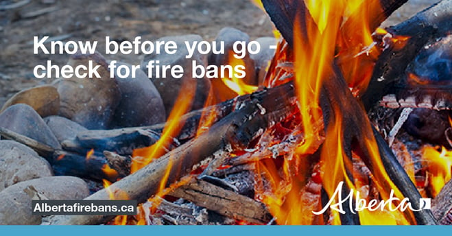
- Before you head out this weekend, check out the albertafirebans.ca website or download the app to stay informed.
- For road closure information, please visit 511.alberta.ca
- For information regarding smoke in the area, you can visit firesmoke.ca
- NASA FIRMS Fire Information website is a great resource to give an idea of the location of wildfires in the area, but note that the data is based on interpolation and often can make the wildfire look larger then it actually is.
- To view the provincial wildfire danger map, click here.
ALBERTA WILDFIRE INFORMATION
- Subscribe to the Edson Forest Area wildfire update to receive an email when new information is posted.
- Download the Alberta Wildfire App for Apple and Android device.
- Join the conversation on Facebook, Twitter or Instagram.
For more information, please contact: