

Evacuation Information
Peerless Trout First Nation
Protecting human life and structures remains a top priority. As a result, an evacuation order has been placed on Peerless Trout First Nation. For more information, visit www.emergencyalert.alberta.ca or download the Alberta Emergency Alert app. You can also visit www.facebook.com/peerlesstroutfirstnation/ for further community updates.
Bigstone Cree Nation
A 4-hour evacuation alert is in place for Bigstone Cree Nation Reserves B and D in the Wabasca area. For more information, visit www.emergencyalert.alberta.ca or the MD of Opportunity Emergency Management Facebook page (https://www.facebook.com/MD-of-Opportunity-No-17-Emergency-Management-1791455711074682/).
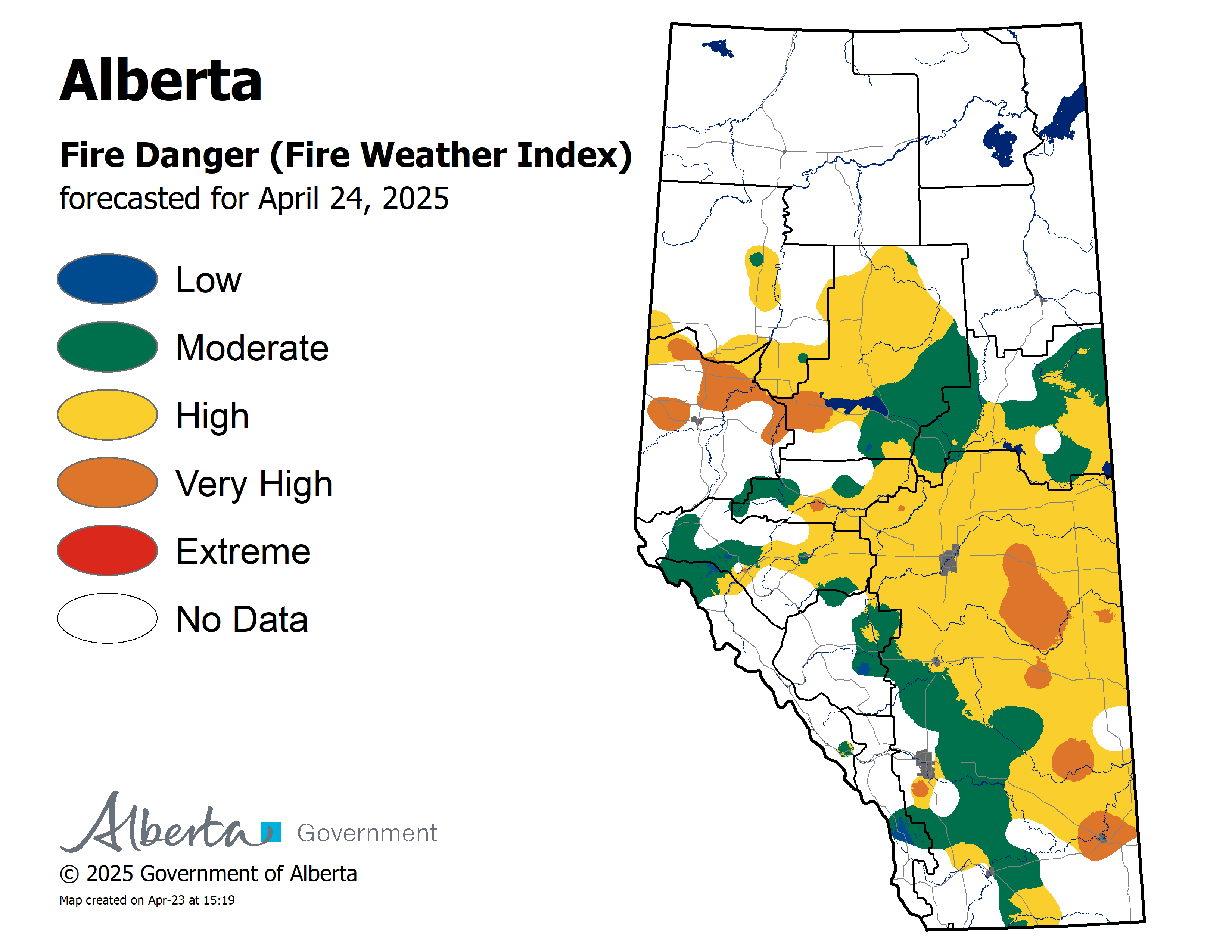
Wildfire Danger
The wildfire danger remains VERY HIGH to EXTREME in the Slave Lake Forest Area. Click here to view the wildfire danger map for Tuesday.
We did receive some rain on the west side of the Slave Lake Forest Area click here to view map of rain that fell over night. However areas east and north did not receive rain.
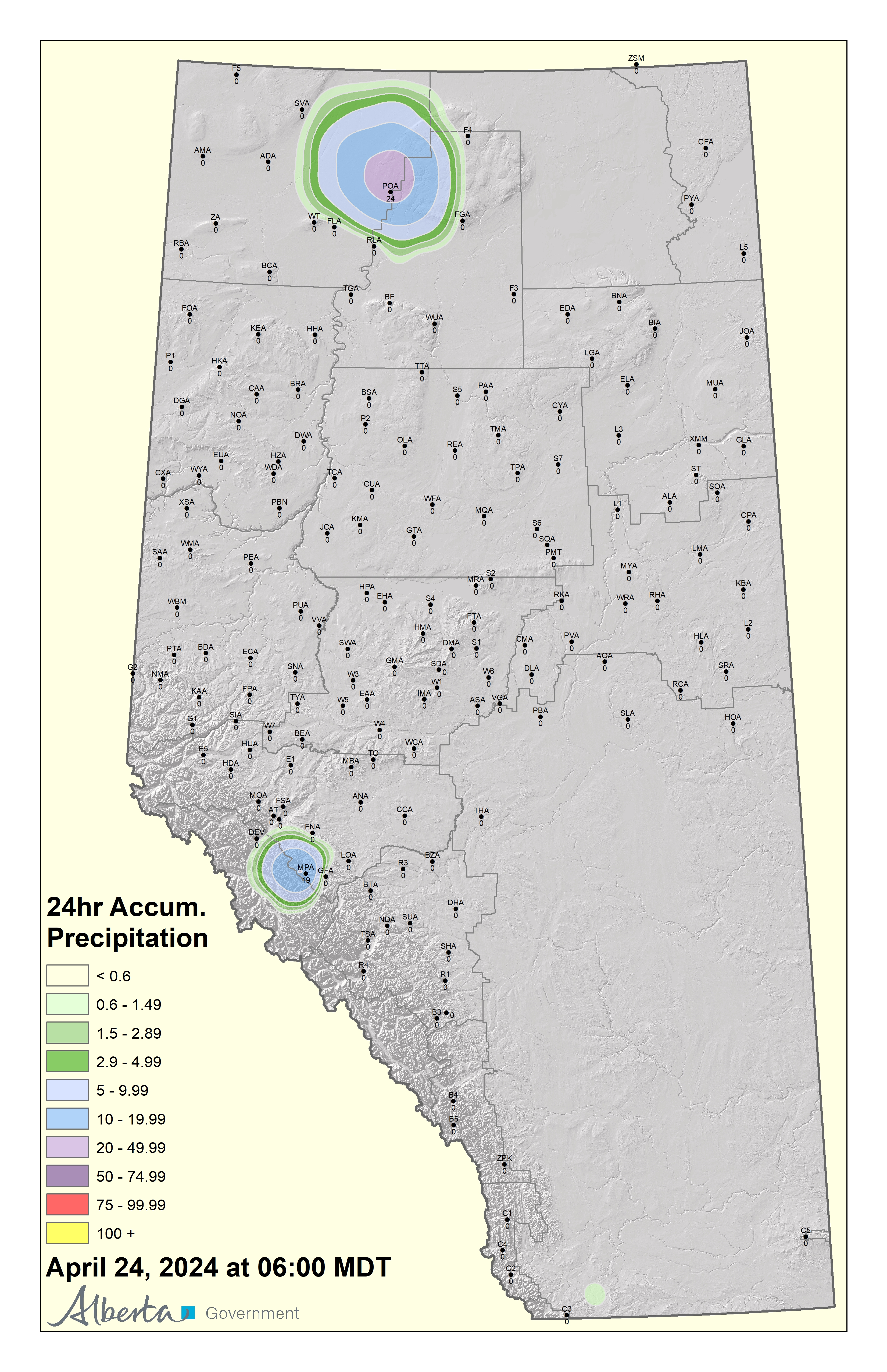
Strong and gusty winds are expected again today. Under these dry and windy conditions, a fire will ignite easily and spread very quickly. Firefighters are urging everyone to use caution and report wildfires immediately by calling 310-FIRE or #FIRE on your cell phone.
There is a chance of thunderstorms with lightning this afternoon/evening. Firefighters in helicopters, airtankers and heavy equipment are ready to fight any new wildfires that may start.
The Fire Ban and OHV Restriction remain in place for areas north of Lesser Slave Lake. To view a map and details regarding the Fire Ban/OHV restriction visit www.albertafirebans.ca
Weather
For today the temperature will be 18 to 21 degrees. Winds will be from the southwest/west 25 kilometres per hour gusting up to 40. There is a chance of thunderstorms with lightning this afternoon/evening.
Smoky conditions are expected to continue. Click here to view the air quality statement that has been issued. If you experience respiratory difficulties, visit Alberta Health Link or dial 811. Visit www.firesmoke.ca to view the most current smoke forecast.
Wildfire Update
Since March 1st, there have been 115 wildfires and 275, 896 hectares burned in the Slave Lake Forest Area.
There were two new wildfires yesterday. SWF-115 was small and has been extinguished. SWF-114 is classified as being held and is 14 hectares in size.

Photo of firefighter on SWF114.
SWF-114 located south of the hamlets of Canyon Creek and Widewater was deemed being held last night at 10:35 pm. Being held means under the current weather conditions and firefighting efforts applied, the wildfire is not expected to grow.
Last night, airtankers were successful in containing the spread and heavy equipment built a fire guard around the entire wildfire.16 firefighters and three nodwells continue to fight this wildfire.It has been accurately measured to be 14 hectares. Lightning had occurred in the area 48 hours prior.The cause of the wildfire is being investigated.
The evacuation was lifted for Canyon Creek and Widewater last night. An 8-hour alert remains in effect. Click here to view the information alert and visit the MD of Lesser Slave River Facebook Page for more information.
SWF-109 started on June 14th and is located eight kilometres northeast of the town of High Prairie.The wildfire is classified as under control and is 2.0 hectares. Firefighters continue to patrol this wildfire.
SWF-102 started on June 9th and is located 1.3 kilometres west of the Chip/Alpac Road at approximately kilometre 45. It is 193 hectares in size and classified as under control. Firefighters continue to patrol this wildfire.
SWF-090 started on June 2nd and is located 18 kilometres northeast of Trout Lake. It is 187 hectares and classified as under control. Firefighters continue to patrol this wildfire.
For information about the wildfire in Peace River Forest Area - 27 kilometres south of Cadotte Lake click here
Provincial Wildfire Situation
For information on the wildfire situation across the province of Alberta click here.
Click here to view a map of the wildfires burning in Alberta.
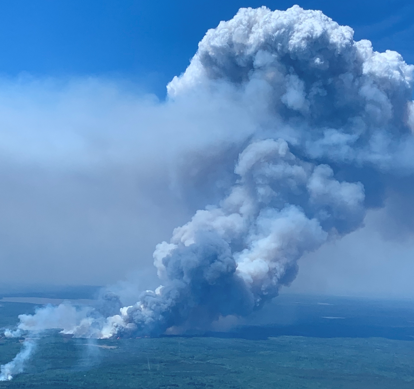
McMillan Complex - northwest portion June 17, 2019
Click here to view a map with imagery and click here for one without imagery of the McMillan Wildfire Complex.
McMillan Complex update - June 18 1:00pm
The north and northwest portions of the fire continued to challenge resources last night, as extreme fire behaviour enabled the fire to grow. Three new excursions grew from the front of the fire, making suppression efforts difficult in that area. Firefighting efforts will be focused on limiting the spread towards identified structures and surrounding communities. The fire is approximately 6km southeast from the community of Trout Lake.
Firefighters, helicopters, airtankers and heavy equipment will continue working on the west, south and east portions of the fire to solidify the perimeter. Heavy equipment reclamation will look to begin in targeted areas of minimal fire activity.
Weather conditions look more favourable today as temperatures should reach 19 degrees on the fire with a relative humidity of 40% and winds from the west/southwest at 25km/hr gusting to 40km/hr. Parts of the fire saw some rainfall this morning, although it didn’t cover the entire area. Wednesday looks to bring cooler temperatures again, with a forecast of 19 degrees, a relative humidity of 40% and winds coming from the northwest at 20km/hr, gusting to 40km/hr. The shift in wind conditions should help firefighting efforts along the north and northwest edges, as the fire will likely burn back into itself, pushing the fire away from structures and communities.
Did you know?
Every effort must be made to restore fireline construction areas to provincial standards. The reclamation process addresses topography, vegetation and soil texture to ensure sustainable growth back into those affected areas.
Structure protection remains in place in the communities of Trout Lake, Wabasca, and Bigstone Cree Nation.
There are 562 firefighters and support staff, 45 helicopters, airtankers, and 41 pieces of heavy equipment fighting this wildfire.
We have been lucky enough to receive support from firefighters and support staff from British Columbia, Saskatchewan, Quebec, Ontario, New Brunswick, Parks Canada, Idaho, Montana, Utah, Nevada and Oregon. Thank you to everyone who has assisted in our operations; the support has been incredible!
SWF-049 remains approximately:
- 9.6 km northwest of Wabasca No. 166C
- 4.9 km and 3.3 km west of Wabasca No. 166B and 166D
- 17.5 km northeast of Marten Beach
- 32.8 km northeast of Slave Lake
- 6 km southeast of Trout Lake
Of the three wildfires in the McMillan Complex, two are under control and one is out of control. SWF-049 has burned into SWF-079 as these fires were in close proximity to each other.
Note: wildfire sizes are subject to change as more accurate readings of the perimeter become available.
SWF-049 is 274,861 hectares and is classified as out of control.
SWF-078 is 137 hectares and is classified as under control.
SWF-099 is 2 hectares and is classified as under control.
For the safety of our firefighters, please obey the reduced speed limit on the highways. Highway 813 from Wabasca to Sandy Lake is open. Highway 754 from Highway 88 to Wabasca is open. Expect delays due to traffic volume and reduced visibility in smoke.Speed reductions in effect. View updates on highways by visiting 511.Alberta.ca or download the mobile app.
Smoky conditions are expected to continue in the Wabasca area. If you experience respiratory difficulties, visit Alberta Health Link or dial 811. Visit www.firesmoke.ca to view the most current smoke forecast. Click here to view the air quality statement that has been issued. Click here for Alberta Health Services Information about Wildfire Smoke.
Structure protection equipment remains in place. Click here for a message from the Fire Chiefs of the Wabasca and Bigstone Cree Nation Fire Departments regarding the fire fighting equipment that has been left in place.
The Fire Ban and OHV Restriction remain in place for areas north of Lesser Slave Lake. To view a map and details regarding the Fire Ban/OHV restriction visit www.albertafirebans.ca

Leah Lovequist
Wildfire Information Officer
Mobile: 780-849-0945
Email:leah.lovequist@gov.ab.ca
Keep up to date on the wildfire situation by subscribing to the Slave Lake Forest Area Wildfire Update or download the free Alberta Wildfire app for Apple or Android devices.


