

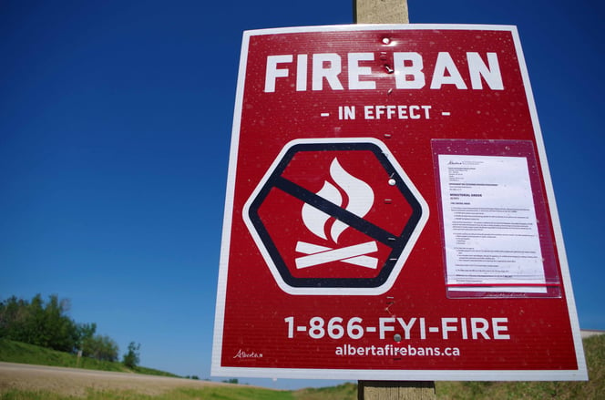
FIRE BAN IN EFFECT
 Due to extreme wildfire danger from dry grass and weather indicators, the Fire Ban and OHV Restriction remains in effect for the Peace River Forest Area and most of northern Alberta.
Existing fire permits are suspended until further notice.
Prohibited
- All open fires including campfires in campgrounds, backcountry and random camping areas and backyard fire pits.
- Charcoal briquettes, turkey fryers and tiki torches.
- Fireworks and exploding targets.
- The use of off-highway vehicles for recreational use on all public lands.
Allowed
- Portable propane fire pits that are CSA approved or UL certified.
- Gas or propane stoves and barbecues that are CSA approved or UL certified and are designed for cooking or heating.
- Catalytic or infrared-style heaters.
- OHVs for industrial use, agricultural use, and traditional use by Indigenous peoples, as well as use on private lands.
The Fire Ban and Off-Highway Vehicle Restriction will remain in effect until conditions improve.
Many nearby municipalities have advisories, restrictions or firebans in place. Please check www.albertafirebans.ca for more information and to view a map of the fireban/OHV restriction boundaries.
WILDFIRE UPDATE (current as of June 2, 2019 at 8 pm)
There were no new fire starts again today. Our initial attack resources spent the day patrolling for any new lightning holdovers but nothing was found.
Numerous resources including crews, aircraft and heavy equipment groups have been placed throughout the area on standby and at the ready to quickly action any new wildfire starts.
There have been 71 wildfires in the Peace River Forest Area this fire season, and each of these wildfires has now been extinguished with the exception of two.
WILDFIRES OF NOTE:
Battle Complex:
PCX-001 (formerly PWF 052 and 054) remains out of control at 52,322 hectares in size Manning/Notikewin area
- Ignitions to clean up some unburnt fuel between the road/guard and the fire's perimeter along the middle of the west side successfully went ahead this afternoon. Ground crews will continue to work in that area to cool the edges in the coming days and reinforce the line that was created. Dozer guard from the Chinchaga Road to the south side of the fire is being completed.
- On the east side, in the bay of previously unburnt trees, fire activity started early, just as was forecasted. Bucketing helicopters were used to reduce the activity and hold the fire from spreading quickly. Ground crews also worked in the area, where it was safe to do so. Early tomorrow morning, if fire activity has lessened, heavy equipment will work in this area to build dozer guard to close the gap between the burned areas of the bay.
- Ground crews continue to reinforce the perimeter in several places around the southeast and northeast portions of the fire and to cool and hot spots there.
- Structural protection crews were on site overnight last night due to the increase in fire behaviour observed. They continue to test and maintain gear installed on several properties in the area
PWF 070 is now classified as under control at 251 hectares in size west of Keg River. The fire has been completely surrounded by dozer guard and the perimeter has not changed since Monday of last week. Firefighters and aircraft are continuing to work towards extinguishing this fire and do not expect the perimeter to grow beyond the current boundaries.
HWF 042 (Chuckegg Creek Fire)
For updates on this fire, please visit
http://srd.web.alberta.ca/high-level-area-update
For your safety and the safety of the numerous firefighters working to contain these wildfires, please stay obey the access restrictions and stay out of the area if you do not need to be there.
For information on the wildfire situation across the province of Alberta, visit: wildfire.alberta.ca.
FIRE WEATHER
The forecast for the next few days generally includes decreasing temperatures and increasing humidity. The forecasted temperature for tomorrow is 13 degrees with a chance of small amounts of rain. The humidity is expected to reach 45% and winds will blow in from the southwest at 20 km/hr, switching to northwest 20 km/hr in the afternoon.
Tuesday's forecast is similar to Monday's with slightly warmer temperatures and lighter winds.
SAFETY NOTICES
EVACUATIONS
County of Northern Lights:
All evacuees are requested to report at the Registration Centre located at the County of Northern Lights Main Office building at #600-7th Ave NW Manning. Registering helps the County of Northern Lights to keep you informed throughout this situation and for re-entry into your community.
- northward from township road 910 (North Star Road)
- Southward of township road 922 (Notikewin Road)
- everyone west of range road 231
For more information on evacuation alerts, visit Alberta Emergency Alert or download the free Alberta Emergency Alert app.
ROAD CLOSURES
For information on road closures and other access related hazards, visit Alberta 511 or download the free Alberta 511 app.
SMOKE
Smoke may be drifting into the area for the foreseeable future. Anyone with health concerns should check with Alberta Health Services or call 811 for 24/7 health advice from Alberta Health Link. For a smoke forecast map, visit Wildfire Smoke Forecasts for Western Canada.
FIRE PERMITS SUSPENDED
All fire permits have been suspended, effective on May 16 at 6 pm. No fire permits will be issued until the fire danger conditions improve.
Please call the Peace River Forest Area office at 780-624-6190 if you have any questions about fire permits.
DO YOUR PART TO PREVENT WILDFIRES
Please continue to respect the fire ban and quad restriction currently in effect.
FIRESMART
You can protect your home from wildfire
Protecting your home from wildfire starts with simple actions. Whether you are doing regular yard maintenance or making large scale changes during renovations or landscaping, you can make choices that will help protect your home from wildfire.
Learn more at firesmartcanada.ca.
FOR MORE INFORMATION

- Bookmark the Peace River Wildfire Update and check for updates anytime or subscribe to have it emailed to you
- Download our app, available for Apple and Android devices.
- You can also find us on Facebook,Twitter, Youtube
- or visit www.wildfire.alberta.ca
Or contact:
Crystal Burrows
Wildfire Information Officer
(780) 618-6215
crystal.burrows@gov.ab.ca
Report Wildfires 310-FIRE (3743)