

At this time, airtankers and helicopters are fighting a wildfire located north of kilometre 20 on Highway 754. The Highway is closed at this time. Check 511 frequently. 511 Alberta's Official Road Reports
Smoke
Winds from the northwest are causing smoke from wildfires in northern Alberta and the Northwest Territories to drift into the Slave Lake Wildfire Management Area. Anyone with health concerns should check the Alberta Health Services website or call 811 for 24/7 health advise from health link Alberta. For a smoke forecast map please visit Wildfire Smoke Forecasts for Western Canada.
Wildfire Hazard
With strong and gusty winds expected to continue late into the evening, the wildfire hazard is EXTREME for the Slave Lake Wildfire Management Area. Use extreme caution while out enjoying our forests and report wildfires immediately by calling 310-FIRE (3473). The forests are very dry and under windy conditions a wildfire will spread very quickly.
Weather Forecast
For Saturday, the forecast is calling for cooler temperatures and a good chance of rain for the Slave Lake Wildfire Management Area. Winds will be from the north 25 gusting up to 50 kilometres per hour.Until there is rain on the ground, conditions will remain dry, a wildfire will ignite easily and spread very quickly with the strong and gusty winds.
There were two new wildfires today. Both were quickly contained and extinguished. We have six out of control wildfires burning in the Slave Lake Wildfire Management Area. Communities are not being threatened.
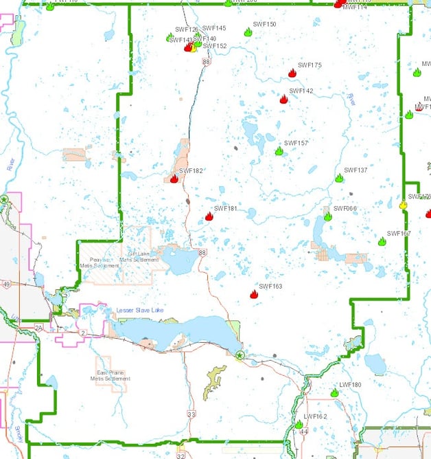

Photo of SWF 140 at 6:15 pm July 3
Slave Lake Wildfire number 140 was caused by lightning on June 30th and is located 60 kilometres north of Red Earth Creek. This wildfire did grow under the windy conditions today and is estimated to be 3500 hectares. At this time, the wildfire is not threatening highway 88 and the highway is now open from north of Red Earth Creek to South Tallcree. Check 511 for road conditions.
Slave Lake Wildfire number 142 was caused by lightning on June 30th and is located 26 kilometres northeast of Peerless Lake. Under the windy conditions this wildfire grew yesterday and is estimated to be 53 hectares. 16 firefighters and two helicopters are fighting this wildfire.

Photo of SLW 163 at 4:50 pm July 3
Slave Lake Wildfire number 163 started on June 30 and is located north of kilometre 20 on highway 754. This wildfire did grow today under the windy conditions. The wildfire has been measured and it is 750 hectares. Highway 754 has been closed. Check 511 frequently. 511 Alberta's Official Road Reports
Slave Lake Wildfire number 175 was a holdover lightning wildfire which was discovered on July 1st and is located 36 kilometres northeast of Peerless Lake. Under the windy conditions this wildfire grew and is estimated to be 1200 hectares. We are constantly monitoring this wildfire with aircraft.
Slave Lake Wildfire number 181 started late in the afternoon of July 2nd and is located 49 kilometres southeast of Red Earth Creek. This wildfire is estimated to be 15 hectares.16 firefighters and two helicopters are fighting this wildfire.
Slave Lake Wildfire number 182 started on July 2nd and is located south of Swampy Lake approximately 23 kilometers south of Loon River First Nation. A dozer guard has been completed around the wildfire and it did not spread outside of it today.There are 16 firefighters and two helicopters working on this wildfire. The wildfire was accurately measure and is 75 hectares.
Check the Alberta Wildfire App or click here for the location and status of these wildfires. Download the free Alberta Wildfire app for Apple and Android devices.
Since April 1, in the Slave Lake Wildfire Management Area there have been 184 wildfires that have burned a total of 6,922.53 hectares.
For information on the wildfires burning in Alberta visit the Wildfire Status Map at www.wildfire.alberta.ca or download the Alberta Wildfire App.

A FIRE ADVISORY for the Slave Lake Wildfire Management Area is in effect as of 10:00 am July 2. Existing permits are suspended and no new permits will be issued. Exceptions are burn barrels, smudges, sweat lodges and smokehouses.These will be allowed. A valid permit is required and conditions must be followed. Safe campfires are allowed in backyards, campgrounds, backcountry and random camping areas.
Fire works in the Forest Protection Area are not allowed at this time.
Check www.albertafirebans.ca for up to date information on the fire advisory.
We thank you for your cooperation. Abiding by the fire advisory you help keep our firefighters free to fight existing wildfires any new wildfires that may start.

Soak it, Stir it up and Soak it Again
Make sure your campfire is out. Soak it thoroughly, stir it up and soak it thoroughly again. Hold your hand above the ashes to check for heat. Click here to learn how you can make sure your campfire is out.
Help prevent wildfires while riding your off-highway vehicle
When riding your off-highway vehicle be sure to stop often and clean any debris from the hotspots. Unchecked, the debris can build up, begin to smolder and fall away sparking a wildfire. Click here to learn how you can prevent wildfires while riding your off-highway vehicle.
Thanks for doing your part to prevent wildfires.
Unless conditions change, you can expect your next wildfire update July 4th.
Leah Lovequist- Wildfire Information Officer
Slave Lake Wildfire Management Area
Office: 780.849.7412
Mobile: 780.849.0945
Leah.Lovequist@gov.ab.ca
To report wildfires call 310-FIRE
For information about wildfires in Alberta follow us on Twitter @ABGovWildfire or Facebook. Download the free Alberta Wildfire app for Apple and Android devices.