

The fire danger in the Peace River Forest Area (PRFA) remains VERY HIGH.
A fire restriction is in effect for the PRFA. All outdoor wood fires are banned on public lands, including backcountry and random camping. The use of fireworks and exploding targets are also prohibited. Please visit AlbertaFiresbans.ca for more information. For further information and maps on smoke please go to Smoke Forecast - FireSmoke.ca
To see the forecasted fire danger, click here, updates daily at 3:00 PM
Please do not report smoke or flame from within an active wildfire area. Firefighters are diverted from essential tasks to respond to fires reported by the public. You may see smoke or flame within the existing boundary of a wildfire; this is normal.
Since January 1, there have been 101 wildfires in the Peace River Forest Area (PRFA) burning a total of 19,596 hectares (ha).
PWF094 was discovered July 10 and is estimated to be 1.62 hectares in size. It is classified as being held (BH).
PWF091 was discovered July 8. It is classified as out of control (OC) at 184.7 hectares. Two helicopters are bucketing water on this fire, and a 20-person crew of Australian firefighters is now working on this fire.
PWF093 was discovered July 8. It is classified as out of control (OC) at 538 hectares.
PWF090 was discovered July 6 and is estimated to be 49 hectares in size. It is currently classified as being held (BH).
PWF082 was discovered on June 30. It is approximately 7,104.5 hectares in size and classified as out of control (OC). It is located south of Chinchaga Wildland Provincial Park. Operational plans for this wildfire are in development and the fire is being monitored.
PWF074 was discovered June 28 and is estimated to be 101 hectares in size. It is located approximately two kilometers northwest of Little Buffalo and is classified as being held (BH). Firefighters are working to put out spot fires and extinguish the fire's interior. Some flaring in the fire's interior is being bucketed with water by helicopters. Preventative structural protection is in place for threatened structures. It is currently 100 per cent contained.
An evacuation order for the community of Little Buffalo has been lifted and a re-entry plan is being implemented. For information, residents can call Joe Auger at 780-625-1503, or visit Northern Sunrise County. Residents are asked to be cautious of ongoing firefighting activities.
GWF018 is currently classified as being held (BH). It is now estimated to be 49,327 ha in size. Firefighters and helicopters continue to work on this wildfire and monitor the area. Pockets of vegetation within the interior of the fire perimeter continue to show active fire behaviour, however they are not likely to escape the containment lines.
PWF034 is located approximately 21 kilometers east and northeast of Worsley and 21 kilometers North of Cleardale. It is classified as under control (UC) at 587 ha. Firefighters continue to patrol this wildfire and work on any hotspots found.
Continue to stay informed by subscribing to Alberta Wildfire updates by entering your email. To view wildfires on a map, download the AB Wildfire App or visit the Wildfire Status page.
Caution is advised when travelling on area highways due to smoke conditions, especially in low lying areas. For road closures, visit 511 Alberta.
All wildfires in Alberta are investigated and these wildfires remain under investigation. To learn more about wildfire classifications, click here.
The Kimiwan Complex
Fire behaviour on the Kimiwan Complex is expected to be HIGH.
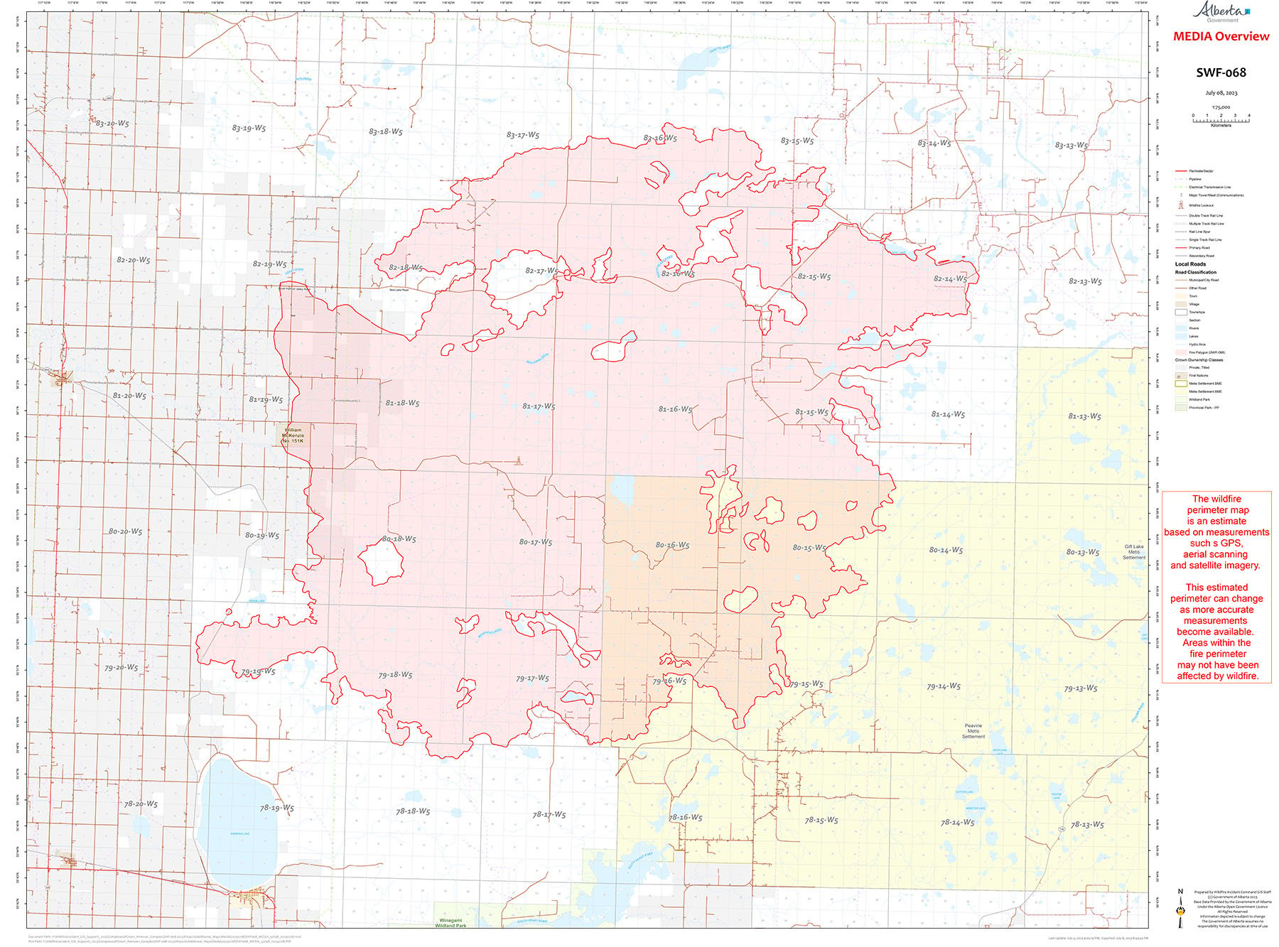
SWF068 is classified as Out of Control (OC) and is 143,039 hectares.
A few days of cooler temperatures and higher humidity resulted in decreased fire behaviour and allowed firefighters to complete various sections of containment lines and assisted in suppression efforts. The fire is being assessed today to assist in prioritizing areas where firefighters will have the most benefit.
Firefighters continue to prioritize containment lines in areas of potential concern, continuing with patrols near communities and infrastructure. Heavy equipment is being utilized across the fire, with dozer lines being followed up with ground crews to reduce possible future flare ups. There are currently 244 firefighters and support personnel working on this fire.
PWF038 is classified as Under Control (UC) and is 6,533 hectares.
For more information about wildfire in or near municipalities impacted by SWF068, please go to Northern Sunrise County or the MD of Smoky River
THE BASSET FIRE | HWF058, PWF067, PWF079 |
This fire is being managed by an Incident Management Team.
For more information please visit the High Level Forest Area Update.
Colby Lachance
Wildfire Information Officer| Alberta Wildfire
Basset Wildfire (HWF058)
Ministry of Forestry and Parks
Government of Alberta
Cell: 780-404-9186
wf.hwf0582023-iof.i@gov.ab.ca (Basset Email)
colby.lachance@gov.ab.ca (Lac La Biche Email)
Stay away from active wildfire areas for your safety and to ensure firefighters can do their job safely, please stay away from active wildfire areas. Your cooperation is essential.
Dangerous trees Be extra cautious near burnt areas and avoid forested areas that have been recently affected by wildfire. Hazards remain from falling trees or branches, especially if windy, deep ash pits and burning peat.
Reporting wildfires Please do not report smoke or flame from within an active wildfire area. Firefighters are diverted from essential tasks to respond to fires reported by the public. You may see smoke or flame within the existing boundary of a wildfire, this is normal.
Smoke Lingering smoke may still be visible in some areas and in affected communities. Smoke inversions can trap air near the ground causing dangerous driving conditions and poor air quality. Please use extra caution when driving in smoky conditions, and take necessary precautions if you have smoke-related health concerns.
Drones The use of recreational drones over wildfires in Alberta is dangerous, illegal and could result in a fine of up to $15,000* for putting aircraft and people at risk. Please give Alberta firefighters the space they need to do their jobs safely.
Prohibited:
- All outdoor wood fires in backcountry and random camping areas on public land
- Charcoal briquettes in backcountry and random camping areas on public land
- The use of fireworks and exploding targets is also prohibited.
Allowed:
- Wood campfires on private land and in designated campgrounds
- Charcoal briquettes on private land and in designated campgrounds
- Propane/natural gas-powered appliances
- Open flame oil devices (e.g., turkey deep fryers, tiki torches)
- Indoor wood fires contained within a device with a chimney and spark arrestor
- All appliances must be CSA approved and used per manufacturer’s standards
Be advised that Alberta Parks has it's own set of fire ban levels, please visit their website for more information.
![]()
Using FireSmart principles is becoming a way of life for many communities in North America. With so many neighborhoods threatened by wildfire each year, residents are taking action and reducing the risk to their homes, cabins and properties.
To learn more on how you can protect your home and structures from wildfire, visit firesmartcanada.ca or click here to watch videos.
For those that have farm or acreages, this publication may be helpful to keep you FireSmart. Click on the link for the Farm and Acreage FireSmart Magazine.
FOR MORE INFORMATION
- Bookmark the Peace River Wildfire Update and check for updates anytime or subscribe to have it emailed to you.
- You can also find us on Facebook, Twitter and Instagram or visit www.wildfire.alberta.ca
CONTACT
Provincial Information Officer
Wildfire Information Officer
780-420-1968
wildfireinfo@gov.ab.ca
HELPFUL LINKS
Alberta Wildfire StatusAlberta Fire Bans
Air Quality Health Index
Alberta Emergency Alerts
511 Road Reports
Emergency Preparation