

Visit AB 511 for up-to-date information on road closures in the forest area.
A fire ban remains in effect for the Lac La Biche Forest Area.
If you see smoke or flame in the forest area please call 310-FIRE (3473) to report it.
The Kettle River Complex (LCX001) includes 17 wildfires: LWF101, LWF123, LWF124, LWF126, LWF136, LWF139, LWF140, LWF141, LWF142, LWF143, LWF152, LWF155, LWF156, LWF159, LWF162, LWF164, LWF168 and LWF175.
A new Ontario Incident Management Team (IMT) transitioned with an outgoing IMT from Ontario on the afternoon of July 25 and is now committed to managing personnel and resources assigned to the Kettle River Complex of wildfires.
The Kettle River Complex is forecasted to receive a possible 10-20mm of rain throughout the day Friday, July 26. Helicopters were unable to fly, July 25 due to weather conditions.

Weather conditions have limited flight operations at the Kettle River Complex over the past several days.
Visit 511 Alberta for the most up-to-date information on highway closures.
LWF136 – The status of this wildfire has changed to BEING HELD. Fire behaviour on LWF-136 was reported as minimal near the fire’s perimeter yesterday. The fire remains located approximately 12 km northwest of the community of Janvier at a size of 765 ha. Resources committed to this wildfire include 12 pieces of heavy equipment and 63 wildland firefighters.
Heavy equipment has completed construction of the guard around the fire’s perimeter and firefighters continue to work hose lines, working to 100 feet (30m) inside the fire’s perimeter. Helicopters equipped with buckets are available to support ground crews and heavy equipment if weather or visibility conditions permit.
The Regional Municipality of Wood Buffalo (RMWB) has lifted the evacuation alert for the hamlet of Janvier.
LWF164 – The status of this wildfire is OUT OF CONTROL, and it is located approximately 12km northeast of Conklin and south of Highway 881. This is approximately 1400 ha.
Operations staff on LWF-164 reported minimal fire behaviour throughout the day with burning conditions improving slightly in the later afternoon.
There are 12 pieces of heavy equipment and eight wildland firefighters assigned to this wildfire. Firefighters will continue to establish and consolidate hoselines on the dozer guard north of the highway and have established a relay tank. Heavy equipment will work to establish a dozer guard along the west side of the fire. The area of highway impacted by fire has since been contained.

LWF141 – The status of this wildfire is UNDER CONTROL. Good progress was made yesterday on this 36 ha fire, approximately three kilometres north of Chard. A dozer guard was completed on the southern perimeter of the fire, tying in the fire with the water body along its northern perimeter.
LWF152 - The status of this wildfire is OUT OF CONTROL, and it is located approximately 22km northeast of Conklin and 10km southeast of Highway 881. It is currently 475 ha. This wildfire is in close proximity (10 km radius) to industrial facilities. This wildfire is being monitored for growth and fire activity.
LWF159 – The status of this wildfire is OUT OF CONTROL, and it is located in Dillon River Wildland Provincial Park about 12km east of Winefred Lake No. 194B. This wildfire is approximately 4,432 ha.
LWF165 - (Lac La Biche Forest Area) - started on July 17. It is located 20 km south of Crow Lake. This fire is now being managed by the Algar Lake Complex (since July 23). It is classified as OUT OF CONTROL and is currently estimated at 1,883 ha.
Heavy equipment operators have completed containment lines around the portion of LWF165 located on the west side of Highway 63. They have moved over to the portion of the fire located on the east side of the highway along the southern flank, where they will continue to establish containment lines, working eastward away from Highway 63.
For up to date information about road conditions, visit 511 Alberta.
Infrared scans that had been planned for both MWF086 and LWF165 last Wednesday evening were not completed due to unfavorable weather conditions.
There are currently 16 wildfires burning out of control in the Lac La Biche Forest Area. View other active wildfires, their locations and stats on the interactive map on our Wildfire Status page.
LWF173- This wildfire was detected on July 23. It is classified as OUT OF CONTROL at 6 ha. There is currently one helitack crew on this fire. We are conducting early morning tanker operations weather permitting.
LWF171 - This wildfire was detected on July 22. It is classified as BEING HELD at 34 ha. Crews will continue to monitor this fire.
LWF169 - This wildfire was detected on July 21. It is classified as OUT OF CONTROL at 217 ha. This fire is located 6 km east of industry facility. We have had some bucketing suppression, however, visibility is limited. There has been minimal growth on this fire today.
LWF147 - This wildfire was detected July 16. It is classified as OUT OF CONTROL at 6,569 ha. The fire is located approximately 16 km northeast of Heart Lake in the Cold Lake Air Weapons Range. This fire is under investigation.
LWF154 - This wildfire was detected July 16. It is classified as OUT OF CONTROL at 1,290 ha. This wildfire is located within the Cold Lake Air Weapons Range.

A fire ban is in effect as of July 10 in the entire Forest Protection Area of Alberta, including the Lac La Biche Forest Area, due to hot and dry conditions.
Cities, towns, villages and summer villages, as well as federal lands (such as national parks), are exempt from this ban. These jurisdictions have the authority to issue their own bans and may have complementary bans in place.
Visit Alberta Fire Bans to see if a fire ban or restriction is in place in your area.
Under this fire ban:
- All fire permits are suspended or cancelled.
- No new fire permits will be issued.
- Some allowances can be made for essential agricultural and industrial burning, if approved by a forest officer.
Prohibited:
- All outdoor wood fires, including wood campfires on public land, private land, designated campgrounds, and backyard firepits
- Barbeque charcoal briquettes
- Fireworks and exploding targets
Allowed:
- Propane/ natural gas-powered appliances
- Indoor wood fires inside a structure (such as a facility, building, tent or RV) and contained within a device with a chimney and spark arrestor
- Open flame oil devices (such as deep fryers and tiki torches). All devices must be CSA approved and used per manufacturer’s standards.
If you see a wildfire, report it immediately by calling 310-FIRE.
The fire ban will remain in effect until conditions improve.

DRONES are not allowed to be flown within 5 nautical miles (or 9.3 kilometers) of a wildfire.
If you fly a drone within this distance of a wildfire, it immediately halts firefighting operations because it is not safe to be flying with drones in the air. The penalty for interfering with wildfire control operations can land you a court appearance, go to the Government of Alberta website.
For more information from Transport Canada about drones near wildfires, visit Transport Canada's website.
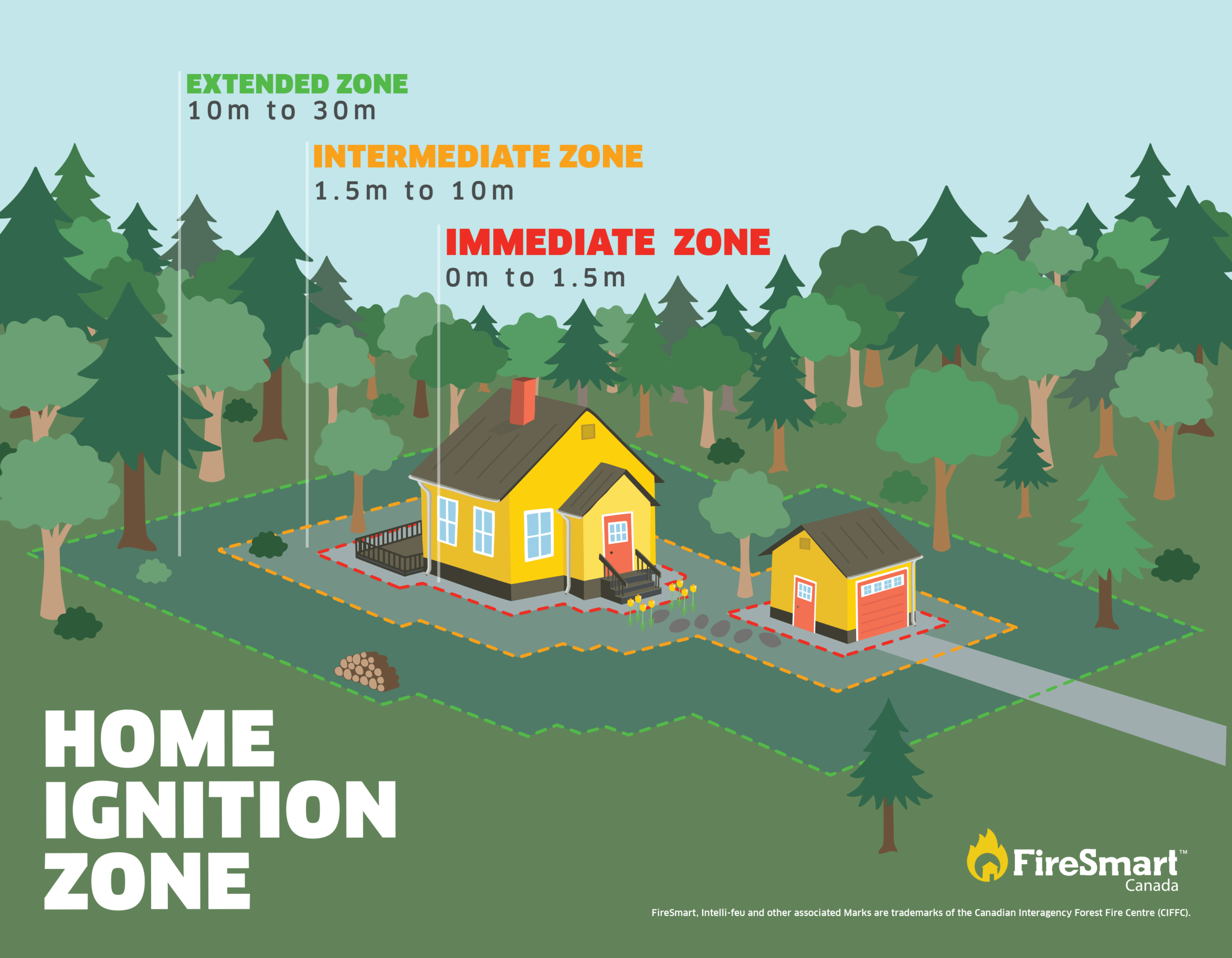
FIRESMART
Your actions today can minimize wildfire damage to your home and property tomorrow. Visit FireSmart Alberta to learn how taking proactive FireSmart measures around your house and yard can increase your property's resistance to wildfire.
Download the Farm and Acreage Guide to Reducing the Risk From Wildfire for additional information.
WILDFIRE INFORMATION
Subscribe to forest area updates to receive them in your inbox.
Download the AB Wildfire Status app, and select the "i" at the bottom to see the most recent update. Sign up to be notified when a new update is published.
Visit Alberta Wildfire for more information on the current wildfire situation.
Visit Alberta Fire Bans to see if there are any fire advisories, fire restrictions or fire bans in effect in your area.
For more information, please contact:


Isabelle Chenard
Ontario Wildfire Information Officer
Phone: 587-919-7419
Email: isabelle.chenard@ontario.ca

LCX001 Information:
Chris Marchand
PH: 1-807-323-1851
Ontario Fire Information Officer
wf.lcx0012024-iof.i@gov.ab.ca
RELATED INFORMATION
Websites:
- Alberta Wildfire
- Alberta Fire Bans
- FireSmart Alberta
- Alberta Emergency Alerts
- Air Quality Health Index
- Wildfire Smoke and Your Health
- 511 Road Reports
- Emergency Preparation
Social media:
Apps: