

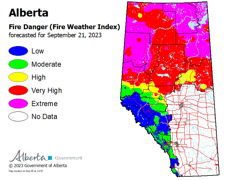
The wildfire danger in the High Level Forest Area is EXTREME which means some of the wildfires have seen more active fire behaviour. There has been increased smoke throughout the day which affects visibility and can cause health concerns. If you are experiencing any respiratory concerns please call Alberta Heath Link at 811.
Temperatures are forecasted to remain warm over the coming days with winds of 20 gusting to 45 over the next few days becoming light on Saturday. Crews are expecting to see more wildfire activity and are monitoring the situation closely. Please stay informed and listen to your local authority for alerts.
FIRE RESTRICTION IN EFFECT | SEPTEMBER 1, 2023
A fire restriction is in effect for the High Level Forest Area, due to warm, dry and windy conditions. The fire restriction will remain in effect until conditions improve.
Under this restriction:
- Existing fire permits are restricted, suspended or cancelled and no new fire permits will be issued.
Prohibited:
- All outdoor wood fires are banned on public lands, including backcountry and random camping areas.
- Fireworks and exploding targets.
Allowed:
- Safe wood campfires on private lands and in designated campgrounds.
- Backyard fire pits
- Charcoal briquette barbeques.
- Propane/ natural gas-powered appliances.
- Indoor wood fires contained within a device with a chimney and spark arrestor.
- Cooking, warming and lighting devices that are CSA approved and used as per manufacturer’s standards.
Never leave a campfire unattended. Soak it, stir it and soak it again until cool to the touch to ensure it is extinguished. If you see a wildfire, report it immediately by calling 310-FIRE.
WEATHER |
The forecast for today is a temperature of 21 degrees a relative humidity of 40 percent with winds south/southwest 20 km/h gusting up to 45 km/h. Gusty winds are expected to continue into the weekend and therefore fire activity is expected to increase. There is no significant precipitation in the forecast.
HIGH LEVEL FOREST AREA | WILDFIRE SITUATION | SEPTEMBER 21, 2023 AS OF 12:00 PM
There are 23 wildfires in the High Level Forest Area. Of these fires, three are classified as out of control (OC), 14 are being held (BH) and six are under control (UC). To see a map of the wildfires in the High Level Forest Area and across the province please click here.
wildfires of interest;
HTZ001 | A wildfire from the Northwest Territories has entered the High Level Forest Area, northwest of Indian Cabins. The wildfire is classified as out of control (OC) and is approximately 14 km west of highway 35. This wildfire has a last recorded size of 215,632 hectares. Airtankers have established retardant lines to protect nearby infrastructure and crews have established structure protection at Indian Cabins. Due to poor visibility and difficult terrain crews have had limited access to the area. For more information on this wildfire north of the Alberta border, visit the NWT Fire Info Facebook page or website. For any road closures please visit 511.alberta.ca
HBZ001 | A wildfire from British Columbia has entered the High Level Forest Area, southwest of Rainbow Lake. The wildfire is classified as out of control and has a last recorded size of 32,984 hectares.
HWF030 | The Paskwa fire (HWF030) was detected on May 2, 2023. It extends along the south side of the Peace River from the community of Fox Lake into Wood Buffalo National Park and is approximately 8 km south of the community of Garden River. The wildfire is 96,582 hectares in size and is classified as under control (UC). Be extra cautious near burnt areas and avoid forested areas that have been recently affected by wildfire. Hazards remain from deep ash pits, burning peat and falling trees or branches, especially if windy.
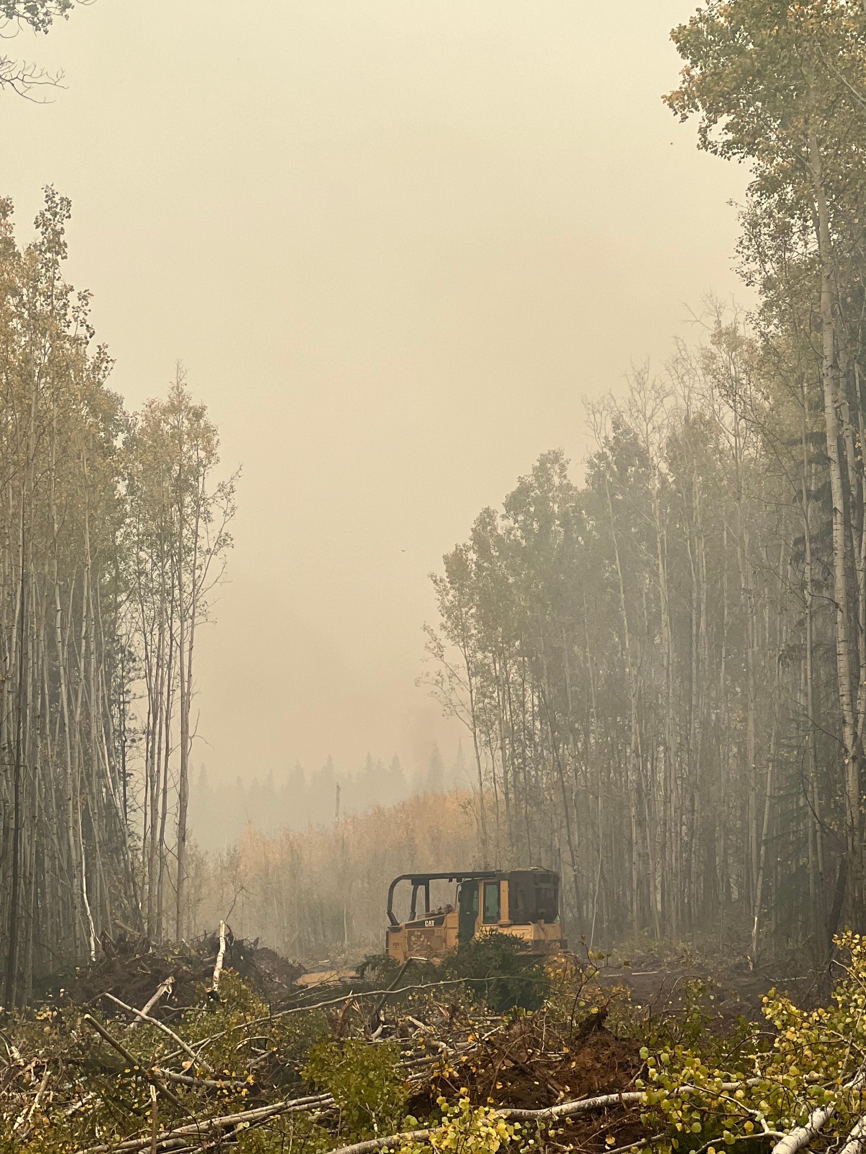
Heavy equipment is working to establish a contingency guard, southwest of High Level. September 21, 2023.
THE BASSET FIRE (HWF058) | SEPTEMBER 21, 2023 AS OF 12:00 PM
An Incident Management Team (IMT) is managing this wildfire.
HWF058 | This wildfire is classified as out of control (OC) at 126,178 hectares in size. This wildfire is approximately 44km southwest of the Town of High Level and is 15 km from the northwest corner boundary of the Paddle Prairie Metis Settlement, approximately 10 kilometers south of highway 58 and 38 kilometers west of highway 35.
There was no significant growth reported from yesterday or overnight however, with the return of strong gusty winds fire activity is expected to increase today.
The forecast for today is calling for gusty winds, south/southwest 20 km/h gusting up to 45 km/h. In addition, the gusty winds are expected to persist until Saturday.
The guards in place on the south end of the wildfire continue to hold and there is no threat to Paddle Prairie Metis Settlement at this time. Drought conditions continue to challenge firefighting efforts with no significant rain in the forecast. The smoky conditions on the north side continue to challenge firefighter and aircraft access into this area of the fire.
Heavy equipment continues to establish control lines around the east side of the fire working from the Chingaga River, east towards the Chain Ponds. Heavy equipment is also working to establish a contingency line, southwest of the Town of High Level. Working west off of highway 35 near West Fraser and then heading north towards highway 58.
Heavy equipment worked throughout the night and will continue today to establish a fire guard along highway 58. In conjunction Atco is working to protect the powerlines.
There is no immediate threat to any communities but as the situation can change quickly please stay informed and listen to your local authority for alerts.
There are 60 firefighters, support staff, 18 helicopters and 34 pieces of heavy equipment working on this fire. Additional resources have been requested.
Message from ATCO Electric
Proactively, ATCO is taking the following measures to protect the transmission line along highway 58;
- Removing dry vegetation surrounding the poles/assets.
- Adding resiliency measures like fire mesh on wood utility poles.
ATCO continues to monitor the situation and work with Alberta Wildfire. They will advise communities if the fire risk to the powerlines becomes more imminent.
ATCO would also like to remind everyone to take caution and stay clear of any downed power lines. Downed power lines can be extremely dangerous and contacting an energized line can seriously injure or kill you. If you see a downed power line, please stay at least 10 metres away, call our Emergency outage line 1-800-668-5506 and keep everyone safe from the area.
THE LONG LAKE FIRE (HWF036) | SEPTEMBER 21, 2023 AS OF 12:00 PM
An Incident Management Team (IMT) is managing this fire.
HWF036 | This wildfire is classified as being held (BH) at 188,333 hectares. Being held means that given current weather conditions and resources, the wildfire is not anticipated to grow past expected boundaries.
Crews continue to work on hotspots along the eastern perimeter and heavy equipment continues to strengthen and extend the containment lines in key areas. The northeast guard protecting the community of Chateh continues to hold.
The west and southwest side is where the most activity has been reported and therefore access restrictions have been put in place.
The Town of Rainbow Lake in consultation with the Dene Tha' First Nation, Mackenzie County and Alberta Wildfire have restricted access to areas southwest and west of the Town of Rainbow Lake. There are barricades placed to restrict access both west and south of the Town of Rainbow Lake due to safety concerns. South of Baseline (Bivouac) Road up to the BC boarder, and south of the Town of Rainbow Lake including the lake itself including areas further south. This area is seeing intense wildfire behaviour and is dangerous to the public. The Town of Rainbow Lake is working closely with partners to monitor the situation and will inform the public once the area is safe to travel in again.
There are 34 firefighters, support staff, 7 helicopters and 30 pieces of heavy equipment working on this fire.
Stay away from active wildfire areas | For your safety and to ensure firefighters can do their job safely, please stay away from active wildfire areas. Your cooperation is essential.
Dangerous trees | Be extra cautious near burnt areas and avoid forested areas that have been recently affected by wildfire. Hazards remain from deep ash pits, burning peat and falling trees or branches, especially if windy.
Reporting wildfires | Please do not report smoke or flame from within an active wildfire area. Firefighters are diverted from essential tasks to respond to fires reported by the public. You may see smoke or flame within the existing boundary of a wildfire, this is normal.
Smoke | Lingering smoke may still be visible in some areas and in affected communities. Smoke inversions can trap air near the ground causing dangerous driving conditions and poor air quality. Please use extra caution when driving in smoky conditions, and take necessary precautions if you have smoke-related health concerns.
Drones | The use of recreational drones over wildfires in Alberta is dangerous, illegal and could result in a fine of up to $15,000* for putting aircraft and people at risk. Please give Alberta firefighters the space they need to do their jobs safely. *Transport Canada
.png?width=659&height=371&name=wildfire%20app%20(2).png)
WILDFIRE INFORMATION
Download the Alberta Wildfire app today and get access to accurate, real-time information on wildfires in your area. You can also find information on fire advisories, restrictions and bans across the province and much more all on your mobile device. Available for Apple and Android.
Before heading out, please check albertafirebans.ca to determine whether there are any fire advisories, fire restrictions or fire bans in effect for your destination.
Subscribe to the High Level Forest Area Update to receive an email when new information is posted. Join the conversation on Facebook, Twitter or Instagram.
WILDFIRE LINKS AND TOOLS
Volunteers, equipment owners/operators or firefighters looking to assist with these wildfires or any of the wildfires within the province can contact EmergencySupportOffers@gov.ab.ca.
There are multiple EVACUATION ORDERS & ALERTS in the Province. Please visit Alberta Emergency Alerts or your community webpage for more information.
To see all the wildfires burning in Alberta click here.
WILDFIRE PREPAREDNESS | Learn how you can prepare yourself for a wildfire by clicking here.