

FIRE RESTRICTION IN EFFECT | SEPTEMBER 1, 2023
A fire restriction is in effect for the High Level Forest Area, due to warm, dry and windy conditions. The fire restriction will remain in effect until conditions improve.
Under this restriction:
- Existing fire permits are restricted, suspended or cancelled and no new fire permits will be issued.
Prohibited:
- All outdoor wood fires are banned on public lands, including backcountry and random camping areas.
- Fireworks and exploding targets.
Allowed:
- Safe wood campfires on private lands and in designated campgrounds.
- Backyard fire pits
- Charcoal briquette barbeques.
- Propane/ natural gas-powered appliances.
- Indoor wood fires contained within a device with a chimney and spark arrestor.
- Cooking, warming and lighting devices that are CSA approved and used as per manufacturer’s standards.
Never leave a campfire unattended. Soak it, stir it and soak it again until cool to the touch to ensure it is extinguished. If you see a wildfire, report it immediately by calling 310-FIRE.
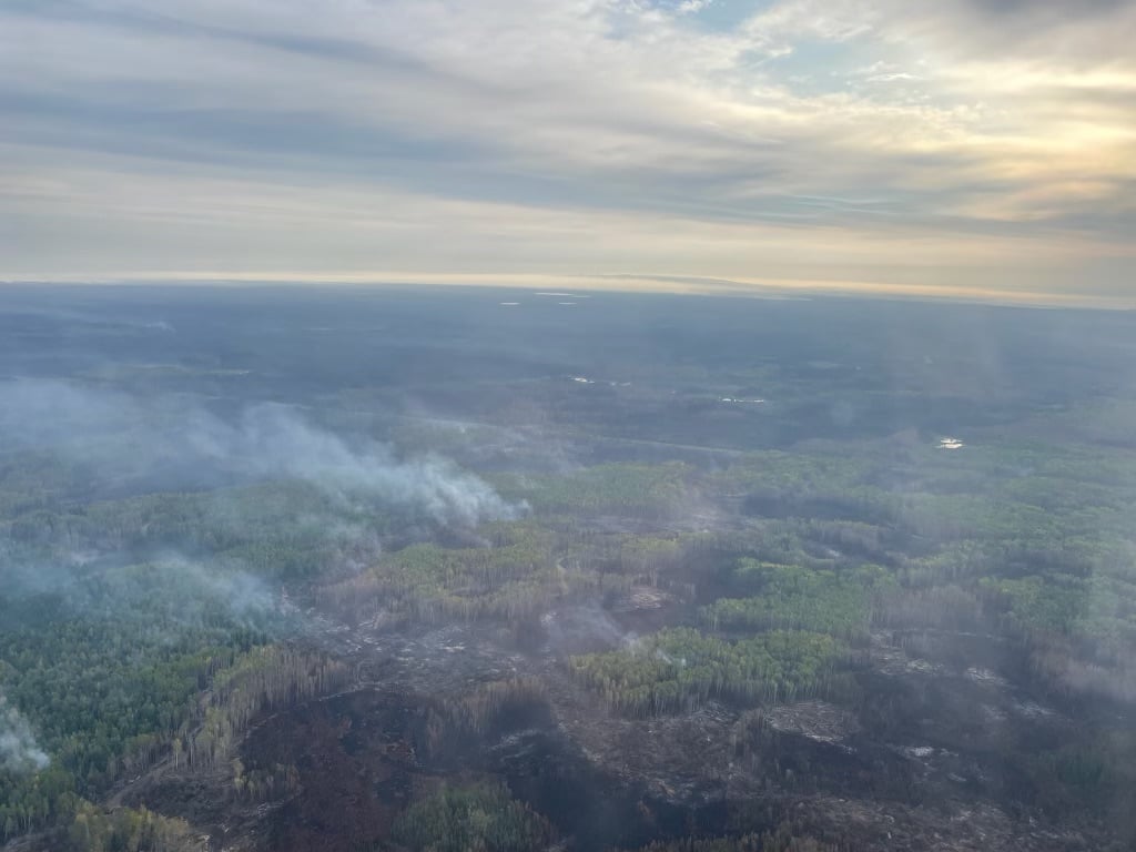
The Basset fire (HWF058) is being held at 43,432 hectares. September 5, 2023.
HIGH LEVEL FOREST AREA | WILDFIRE SITUATION | SEPTEMBER 8, 2023 AS OF 3:30 PM
There are 20 wildfires in the High Level Forest Area. Of these fires, two are classified as out of control (OC), 11 are being held (BH) and seven are under control (UC). To see a map of the wildfires in the High Level Forest Area and across the province please click here.
Wildfires of interest;
HTZ001 | A wildfire from the Northwest Territories has entered the High Level Forest Area, northwest of Indian Cabins. The wildfire is classified as out of control and is approximately 14 km west of highway 35. This wildfire has a last recorded size of 215,632 hectares. Airtankers have established retardant lines to protect nearby infrastructure as well crews have established structure protection at Indian Cabins. Due to poor visibility and difficult terrain crews have had limited access to the area. This fire has seen an increase in fire activity and is expected to continue due to the expected gusty winds. For more information on this wildfire north of the Alberta border, visit the NWT Fire Info Facebook page or website. For any road closures please visit 511.alberta.ca
HWF030 | The Paskwa fire (HWF030) was detected on May 2, 2023. It extends along the south side of the Peace River from the community of Fox Lake into Wood Buffalo National Park and is approximately 8 km south of the community of Garden River. The wildfire is 96,582 hectares in size and is classified as under control (UC). Be extra cautious near burnt areas and avoid forested areas that have been recently affected by wildfire. Hazards remain from deep ash pits, burning peat and falling trees or branches, especially if windy.
THE BASSET COMPLEX | SEPTEMBER 8, 2023 AS OF 3:30 PM
An Incident Management Team (IMT) is managing this wildfire.
HWF058 | This wildfire is located about 12 km northwest of the Paddle Prairie Metis Settlement boundary marker, where the Haig River meets the Chinchaga River. It is classified as being held (BH) at 43,432 hectares. With the continued hot weather there has been an increase in activity reported on the west and northwest sides of this fire. Airtankers have worked to create containment lines by dropping retardant on the west side as there is difficult terrain for wildfire crews to extinguish hotspots in this area.
Work continues along the southwest side, bucketing operations will continue to cool the area as crews work on hotspots. Dozer guard is being established on this side as heavy equipment moves north.
THE LONG LAKE FIRE | SEPTEMBER 8, 2023 AS OF 3:30 PM
An Incident Management Team (IMT) is managing this fire.
HWF036 | This wildfire is classified as being held (BH) at 188,333 hectares. Being held means that given current weather conditions and resources, the wildfire is not anticipated to grow past expected boundaries.
Firefighters and heavy equipment continue to strengthen and extend the containment lines in key areas to prevent the spread of the wildfire. Helicopters and crews continue to work to protect critical infrastructure on the west side. The northeast guard protecting the community of Chateh continues to hold. Crews are working around the community to patrol and respond to hotspots.
Crews continue to work along the east side of the perimeter and patrol the containment lines to prevent the spread of wildfire. Helicopters will work alongside the crews to monitor and report smoke columns that continue to pop-up and will direct crews to that location for extinguishment.
We are asking the public, residents and industry to use extra caution around areas impacted by wildfire and to not walk near or into burnt areas. There are many hazards that are difficult to see, like deep burning ash pits, unstable trees that can fall because their roots have been burnt away, as well as other unknown dangers. Fallen trees on various roads have been reported. If travelling along these burnt areas, be aware and prepared in case these trees fall onto the road, as your vehicle could become entrapped.
Stay away from active wildfire areas | For your safety and to ensure firefighters can do their job safely, please stay away from active wildfire areas. Your cooperation is essential.
Dangerous trees | Be extra cautious near burnt areas and avoid forested areas that have been recently affected by wildfire. Hazards remain from deep ash pits, burning peat and falling trees or branches, especially if windy.
Reporting wildfires | Please do not report smoke or flame from within an active wildfire area. Firefighters are diverted from essential tasks to respond to fires reported by the public. You may see smoke or flame within the existing boundary of a wildfire, this is normal.
Smoke | Lingering smoke may still be visible in some areas and in affected communities. Smoke inversions can trap air near the ground causing dangerous driving conditions and poor air quality. Please use extra caution when driving in smoky conditions, and take necessary precautions if you have smoke-related health concerns.
Drones | The use of recreational drones over wildfires in Alberta is dangerous, illegal and could result in a fine of up to $15,000* for putting aircraft and people at risk. Please give Alberta firefighters the space they need to do their jobs safely. *Transport Canada
.png?width=1201&height=629&name=WF_Social-images%20(8).png)
WILDFIRE INFORMATION
Download the Alberta Wildfire app today and get access to accurate, real-time information on wildfires in your area. You can also find information on fire advisories, restrictions and bans across the province and much more all on your mobile device. Available for Apple and Android.
Before heading out, please check albertafirebans.ca to determine whether there are any fire advisories, fire restrictions or fire bans in effect for your destination.
Subscribe to the High Level Forest Area Update to receive an email when new information is posted. Join the conversation on Facebook, Twitter or Instagram.
WILDFIRE LINKS AND TOOLS
Volunteers, equipment owners/operators or firefighters looking to assist with these wildfires or any of the wildfires within the province can contact EmergencySupportOffers@gov.ab.ca.
There are multiple EVACUATION ORDERS & ALERTS in the Province. Please visit Alberta Emergency Alerts or your community webpage for more information.
To see all the wildfires burning in Alberta click here.
WILDFIRE PREPAREDNESS | Learn how you can prepare yourself for a wildfire by clicking here.