

The wildfire danger is very high in the High Level Forest Area. With the return of hot and windy conditions new wildfire starts have the potential to spread quickly. Please do your part and respect the Fire Ban and OHV Restriction. Help firefighters respond to new wildfires by calling 310-FIRE(3473).

Under this fire ban:
•All existing Fire Permits are suspended (or cancelled)
•No new Fire Permits will be issued
Prohibited:
•All outdoor wood fires are banned, including wood campfires on public lands, wood campfires on private land and provincial campgrounds
•Backyard firepits
•BBQ charcoal briquettes
•The use of fireworks and exploding targets
•The recreational use of off-highway vehicles (OHV) on public lands, including designated OHV trails
Allowed:
•Propane/natural gas-powered appliances
•Open flame oil devices (e.g., turkey deep fryers, tiki torches)
•Indoor wood fires contained within a device with a chimney and spark arrestor
•All appliances must be CSA approved and used per manufacturer’s standards
•Indigenous people when using an OHV for traditional purposes. Traditional purposes are hunting, fishing, and trapping – including the use of an OHV to travel to the location(s) for these purposes.
•Essential industry-related activities requiring the use of OHVs.
•Off-highway vehicle use is still permitted on private lands.
Stay away from active wildfire areas | For your safety and to ensure firefighters can do their job safely, please stay away from active wildfire areas. Your cooperation is essential.
Danger trees | Be extra cautious near burnt areas and avoid forested areas that have been recently affected by wildfire. Hazards remain from deep ash pits, burning peat and falling trees or branches, especially if windy.
Reporting wildfires | Please do not report smoke or flame from within an active wildfire area. Firefighters are diverted from essential tasks to respond to fires reported by the public. You may see smoke or flame within the existing boundary of a wildfire, this is normal.
Smoke | Lingering smoke may still be visible in some areas and in affected communities. Smoke inversions can trap air near the ground causing dangerous driving conditions and poor air quality. Please use extra caution when driving in smoky conditions, and take necessary precautions if you have smoke-related health concerns.
Drones | The use of recreational drones over wildfires in Alberta is dangerous, illegal and could result in a fine of up to $15,000* for putting aircraft and people at risk. Please give Alberta firefighters the space they need to do their jobs safely. *Transport Canada
There are eight wildfires in the High Level Forest Area. Of these fires, four are classified as out of control (OC), one is being held (BH) and three are under control (UC). Firefighters have responded to one new wildfire today. Please see the updates below regarding the Paskwa fire and the Long Lake fire. To see a map of the wildfires in the High Level Forest Area and across the province please click here.
Wildfires of interest;
HWF064 | This fire is located approximately 24 km northwest of the community of Zama City. This fire is classified as out of control (OC) at 25 hectares. This fire has 20 firefighters, 3 helicopters and airtankers working on this fire. There is no threat to any communities at this time.
HWF058 | This fire is now being managed by the Incident Management Team (IMT) on the Long Lake fire. The Long Lake fire is now the Long Lake Complex. For information regarding fire HWF058, please see the Long Lake Complex update below.
THE LONG LAKE COMPLEX | HWF036, HWF058 | JUNE 9, 2023 AS OF 8:30 PM
HWF036 | This fire was detected on May 3, 2023. This fire is classified as Out of Control (OC) with a last recorded size of 155,325 hectares.
The northeast guard protecting the community of Chateh continues to hold with limited active fire along this edge. Firefighters continue to build containment lines with dozers along Silvertip Road to the gas plant. Cenovus has been working with the Incident Management Team (IMT) to determine a safe return to work plan.
Aircraft is working on hot spots along Baseline Road and north of Baseline Road. Putting out hot spots as they arise. Crews are patrolling and are using hand ignition to burn out unburnt areas to further contain the area. Recent weather conditions have seen reduced fire activity along the power easement and gas plant area. Crews have been working with dozers along the fire edge from Winter Road to the power line easement.
The fire continues to be active west of the Town of Rainbow Lake moving towards the British Columbia border. The Incident Management Team are in daily contact with the IMT in Fort Nelson. Crews are monitoring the fire by air and bucketing priority hot spots.
Please be aware that there is still active fire burning in the area. Residents are reminded not to enter the fire area due to large number of firefighters, and equipment working. Burnt trees continue to fall which are dangerous.
Incident Management Teams from Canada, America and Australia and a large number of helicopters are currently working at the Incident Command Post located at the Town of Rainbow Lake airport to support this fire.
There are 220 personnel supporting fire HWF036. Including wildland and structural firefighters, Incident Management staff and heavy equipment operators. There are 10 helicopters and heavy equipment working this fire.
HWF058 |This fire is located approximately 80 km southwest of the Town of High Level and approximately 23 km northwest of the of Paddle Prairie Metis Settlement boundary marker, where the Haig River meets the Chinchaga River. This fire is classified as out of control (OC) with a last recorded size of 3,596 hectares. There are 25 firefighters, and 3 helicopters dedicated to this fire. Additional resources have been requested.
Due to smoky conditions this morning, crews were unable to access the area safely on the ground however airtankers and helicopters with water buckets worked to cool hotspots where safe to do so. There fire has been very active with growth reported to the west and northwest. There are no communities at risk at this time.
Weather Forecast | Long Lake Complex
Tomorrows forecast is as follow, a temperature of 29 degrees, a relative humidity of 25 percent, with west winds 20-25 km/h gusting 40 km/h. These conditions are expected to challenge firefighters and aircraft.
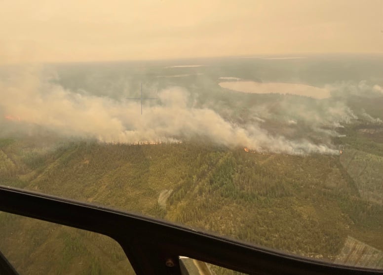
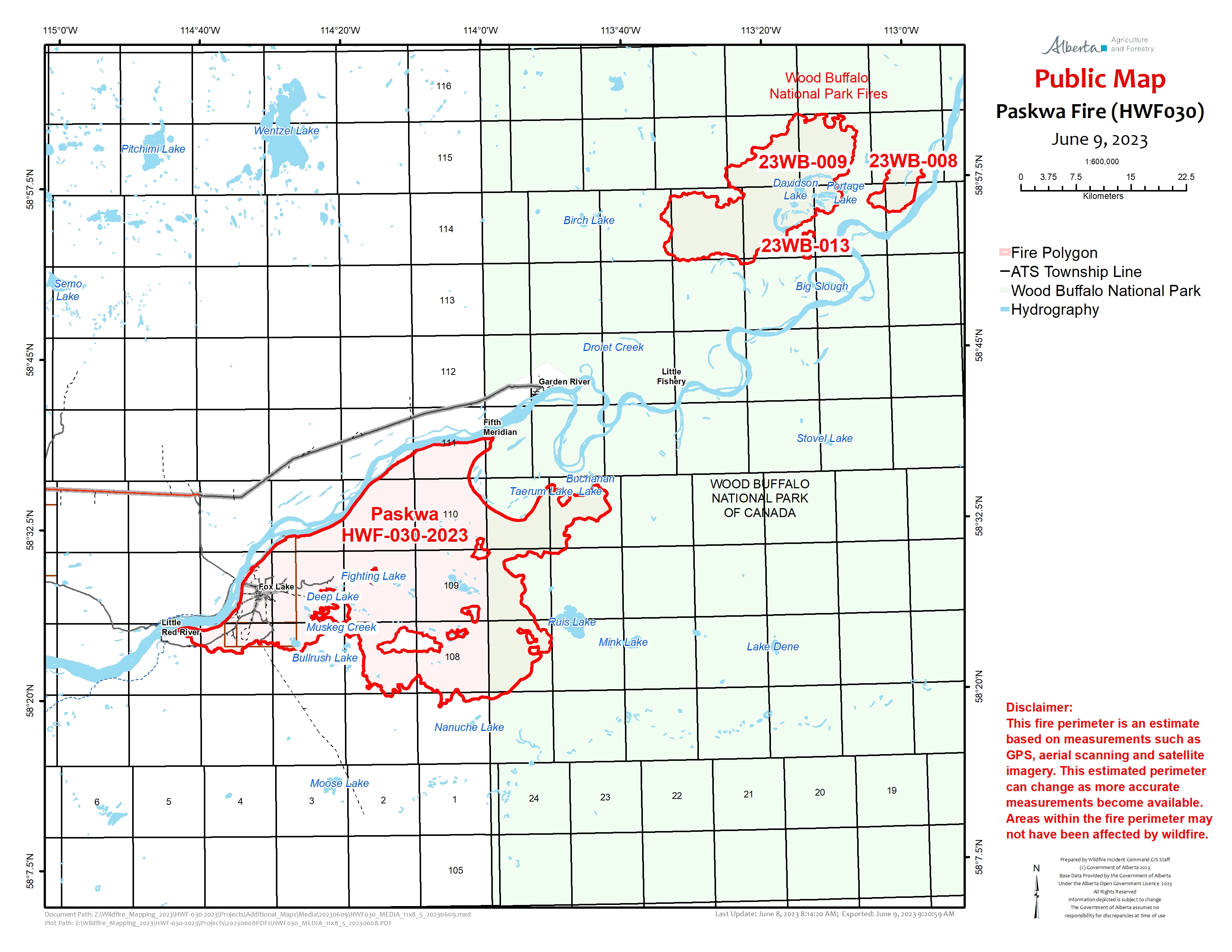
THE PASKWA FIRE | HWF030 | JUNE 9, 2023 AS OF 8:30 PM
The Paskwa fire was detected on May 2, 2023. It extends along the south side of the Peace River from the community of Fox Lake into Wood Buffalo National Park and is approximately 8 km south of the community of Garden River. This fire is classified as out of control (OC) with a last recorded size of 94,172 hectares.
Wildfire behaviour is moderate with lots of smouldering ground fire within the fire perimeter. There are still many areas of smouldering fire that is burning deep into the ground. The top priorities for managing the Paskwa Fire are still full extinguishment of fire in Fox Lake, protecting Garden River, and working toward securing the fire perimeter to prevent significant fire spread.
Today, helicopters continued to bucket along the southeastern perimeter as that area is still very hot but they are making progress. Crews had difficulty working on the southeast side as smoke was heavy in the area but were utilized on the southwest.
Work continues along the entire north-northeast perimeter to extinguish hot spots, keeping the fire south of the Peace River. Today, fire crews continued their work near the Fifth Meridian along the perimeter to extinguish hotspots. Helicopters were also bucketing in the area and actioning any flare-ups that occurred.
Work continues in Fox Lake to extinguish 75m perimeters around all structures and to remove danger trees that are a hazard. Heavy equipment is clearing around some larger fire areas to remove forest fuels and help contain the fire while crews work to extinguish it.
Today, crews worked along Ribbonleg Road to extinguish hotspots and this section has been completed. Crews are also in Prairie Road and Laboucan Road and are working to extinguish hotspots and remove danger trees. Smoke is heavy in the area and it is from a combination of wildfires in Alberta and other provinces.
The high-volume water system, water lines, and sprinkler systems on structures are in place in the community of Garden River and structural firefighters will be available as needed. These are proactive measures to ensure the community is prepared should the fires move closer to Garden River.
There are 113 personnel supporting the Paskwa Fire response consisting of wildland and structural firefighters, incident management staff, and Paskwa Fire Base support staff. There are 12 helicopters and 22 pieces of heavy equipment dedicated to the Paskwa fire.
Weather Forecast | Paskwa Fire
Tomorrow, the forecast is as follows a temperature of 31 degrees with southwest winds of 20-25 km/h gusting 45 km/h. There is an expected cold front to move through which will shift the winds out of the west at 20 km/h gusting 35 km/h.
Evacuation Information and Alerts
Little Red River Cree Nation has an evacuation order in place for the community of Fox Lake. The community of Garden River remains on an evacuation alert. For information regarding the evacuation, please stay informed by visiting the Little Red River Cree Nation’s Facebook page.
The community of Garden River is under an evacuation alert.
Wood Buffalo National Park Fire Update| Davidson Complex
The fires in the Davidson Lake area are approximately 32,909 hectares combined and located 26 km northeast of Garden River. Yesterday was not a big growth day and the same is expected for today. Fire 14 grew about 300 metres toward Trident Creek.
Four bulldozers and two excavators almost completed the first fire guard along the boundary of Wood Buffalo National Park yesterday. They will finish this guard today and add four more bulldozers to the operation. Personnel scouted the second dozer line yesterday and will begin that work in the coming days.
Fire specialists will keep monitoring Fire 14 today for ignition opportunities to tie the fire into Trident Creek to try and limit the fire’s spread. Yesterday, crews continued to assess cabins in the area and maintained sprinkler systems already in place.
Three fire personnel are based in the Garden River area, with one fire crew and a helicopter expected to be stationed out of the Paskwa base in next few days. Incident Management Team members are working on options to move more personnel to the Garden River area as work continues managing the Davidson Lake Fires.
This information has been provided by the Wood Buffalo National Park, Fire Information Officer. For more information regarding fires burning within the Wood Buffalo National Park, please click here.
DO NOT FLY DRONES NEAR WILDFIRES!
The use of recreational drones over wildfires in Alberta is dangerous, illegal and could result in a fine of up to $15,000* for putting aircraft and people at risk. Please give Alberta firefighters the space they need to do their jobs safely.
*Transport Canada
ALBERTA STATE OF EMERGENCY
A provincial state of emergency has been declared. Albertans who require assistance can call 310-4455 for wildfire related information.
WILDFIRE INFORMATION
Download the Alberta Wildfire app today and get access to accurate, real-time information on wildfires in your area. You can also find information on fire advisories, restrictions and bans across the province and much more all on your mobile device. Available for Apple and Android.
Before heading out, please check albertafirebans.ca to determine whether there are any fire advisories, fire restrictions or fire bans in effect for your destination.
Subscribe to the High Level Forest Area Update to receive an email when new information is posted. Join the conversation on Facebook, Twitter or Instagram.
WILDFIRE LINKS AND TOOLS
Volunteers, equipment owners/operators or firefighters looking to assist with these wildfires or any of the wildfires within the province can contact EmergencySupportOffers@gov.ab.ca.
There are multiple EVACUATION ORDERS & ALERTS in the Province. Please visit Alberta Emergency Alerts or your community webpage for more information.
For road closure information, please visit: 511.alberta.ca
Wildfire smoke is a tool used for the location of smoke firesmoke.ca
To see all the wildfires burning in Alberta click here.
.png?width=1200&name=wildfire%20app%20(2).png)
Victoria Ostendorf
Wildfire Information Officer
High Level Forest Area
Mobile: 780-841-9387
Email: victoria.ostendorf@gov.ab.ca