

A Fire Advisory remains in effect for the High Level Forest Area:
Use caution within the Forest Protection Area.
To report a wildfire, call 310-FIRE (3473)
HIGH LEVEL FOREST AREA UPDATE | JULY 6, 2019 AT 11:00 A.M.
There are currently 5 active wildfires in the High Level Area. Of these fires, 1 is Out of Control (OC), 2 are Being Held (BH) and 2 are Under Control (UC). (See below for details on the Chuckegg Creek wildfire).
Click here for a map of all fire locations and their status within the High Level Forest Area.
Wildfires of note:
- Fire number HWF-066 (Jackpot Creek) is classified as Being Held (BH), is located north of Lutose. The fire is approximately 79,834 hectares in size. There are 217 firefighters and support staff, 10 helicopters and 2 pieces of heavy equipment working on this wildfire.
- Fire number HWF-088, is classified as Under Control (UC) and is located 10 km northwest of Hutch Lake. This fire is 216 hectares in size. There are 25 firefighters, 2 helicopters and heavy equipment working on this fire.
NOTE: The next update will be by 7:00 p.m., or if conditions warrant.
Firefighters, helicopters, airtankers and heavy equipment are positioned throughout the High Level Forest Area to respond to any new wildfire starts.
CHUCKEGG CREEK WILDFIRE UPDATE | JULY 6, 2019 AT 11:00 A.M.
Today’s forecasted weather is calling for a temperature of 25 degrees, a relative humidity of 30% and winds out of the southwest at 10-15 km/h. With the return of warmer temperatures and the lower humidity levels, the fire has a potential to see an increase in activity today. Also due to the winds out of the southwest the La Crete and Fort Vermilion area may see an increase in smoky conditions.
On the east side of the fire, west of La Crete, this area of the fire is burning very deep as it is burning in areas of peat moss which has created some challenges for firefighters. Firefighters along with heavy equipment continue to make progress in establishing guard in this area. Helicopters also continue to aid firefighting efforts by continuing to drop retardant and water on the fire perimeter in priority areas.
The dozer guard along the fire perimeter, located on the west side of the Peace River and northwest of Moose Island is complete and firefighters today will be working to establish a water delivery system using large water tanks, pumps, sprinklers and hose line as water access has challenged firefighters. Residents may see many trucks bring in equipment to support this operation, in the La Crete area.
As part of pre-planning for the potential for increased fire behaviour a staging area for wildfire and structure protection resources has been set up at the La Crete Mennonite Heritage Centre ready to respond if there is a need for firefighting efforts east of the Peace River. Structural protection remains in place and is being monitored.
Firefighters are planning to do a controlled ignition operation to the northeast of the Boyer River Cell Tower, if the right weather conditions allow. Other operations are being planed in the area between the fire perimeter and the large spot fire, south of Surette Lake.
Great progress continues to be made by firefighters on the north, west, south, and southeast side by Tompkins Landing as fire activity has been minimal in these areas. Infrared scanning from helicopters will continue. This process identifies thermal infrared radiation from areas that are still smoldering which are also known as hot spots. This process helps firefighters to ensure that these areas are cold and no fire continues to burn. Some of the areas to be scanned are close to residential areas and helicopters may be in the area early in the mornings.
The northern end of the wildfire is fully guarded and mop-up is complete. An infrared scan was conducted on the north perimeter down the west side to Highway 58 and a small number of hot spots were identified. Firefighters are extinguishing remaining hot spots.
On the west side, the guard is complete and firefighters continue with direct attack extinguishing hot spots and mopping-up 100 feet inward, south of Highway 58. The mop-up of this area is expected to be complete in the next few days. In the southwest, hose lay, mop-up and extinguishing hot spots is ongoing.
In the southern end of the wildfire, infrared scanning has identified some hot spots in the Paddle Prairie area and firefighters continue to extinguish hot spots in priority areas. In the southeast side near Tompkins Landing, firefighters continue to extinguish hot spots identified by infrared scanning as well.
- The fire remains 331,988 hectares in size; remains classified as Out of Control (OC)
- There are 1,056 firefighters and support staff, 46 helicopters and 158 pieces of heavy equipment working on this fire.
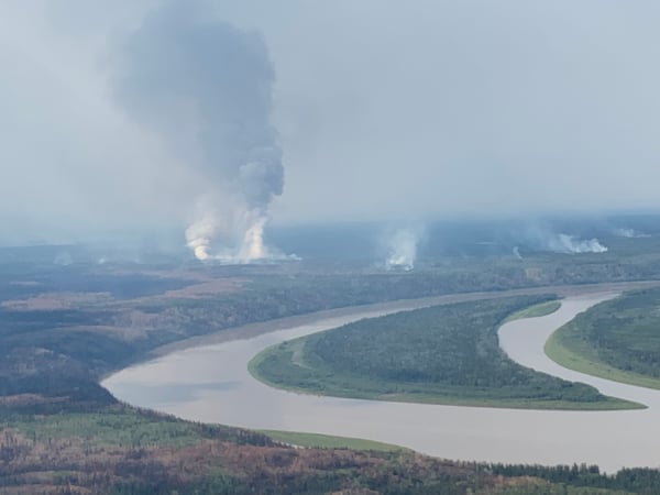
Wildfire activity along the east side of Chuckegg (West side of the Peace River) - July 5


FIRE ADVISORY IN EFFECT FOR THE HIGH LEVEL FOREST AREA
A Fire Advisory remains in effect due to ongoing wildfire activity within the High Level Forest Area.
- Safe Campfires are currently allowed
- Current seasonal permits issued until October 31, 2019 remain valid
- New permits will only be issued for:
- smudges
- burn barrels
- light yard debris
- root piles/rows
To get a fire permit please call 780-926-5407 and leave a detailed message including your home address, burn location and what you plan to burn. A patrolman will contact you to arrange a site visit.
Visit albertafirebans.ca for more information or download the new Alberta Fire Bans mobile app.
PROVINCIAL SUMMARY (JULY 6)
There are currently 14 wildfires in the Forest Protection Area: 1 is Out of Control, 2 are Being Held, 8 are Under Control and 3 have been Turned Over to the responsible parties.
Since March 1, there have been 700 wildfires that have burned 805,813.16 hectares in the Forest Protection Area.
ALERTS AND EVACUATIONS | BE PREPARED, STAY INFORMED
Download the Alberta Emergency Alert App or visit their website by Clicking Here. You can also check with the County, the Town or your local community to see if new alerts or evacuation orders have been issued.
ROAD CLOSURE INFORMATION
To stay informed on all road closure info visit the Alberta Transportation website or download the mobile app.
SMOKE ISSUES
Smoke from wildfires in northern Alberta has caused poor air quality and reducing visibility at times. Winds will continue to shift bringing smoky conditions. For health related smoke issues, please visit Alberta Health Services.
PUBLIC SAFETY - WILDFIRE OPERATIONS
During an active wildfire, the highest priority is the safety of the public and wildfire personnel. Please refrain from entering areas of active wildfire suppression. If you encounter aircraft or helicopter bucketing operations on a water body please move your boat to shore.
The airspace around a wildfire is restricted via NOTAM in a radius of 9 kilometres to an altitude of 3,000 feet above ground level. It is illegal to operate any aircraft not associated with wildfire suppression within the restricted area, including drones. Do not fly drones or UAVs near or within the perimeter of an active wildfire. When a drone is near a wildfire it endangers firefighting personnel and important aerial firefighting operations will be grounded. Those caught in violation can be subject to an automatic court appearance and a fine of up to $100,000.

Matthew Anderson | Wildfire Information Officer | High Level Forest Area
1-866-FYI-FIRE
Victoria Ostendorf | Wildfire Information Officer | Chuckegg Creek Wildfire
Phone: 780-841-9387
1-866-FYI-FIRE
RELATED INFORMATION
- Alberta Wildfire Status
- Alberta Fire Bans
- Air Quality Health Index
- Alberta Emergency Alerts
- 511 Road Reports
- Emergency Preparation