

The High Level Forest Area fire danger is very high throughout the forest area due to increasing temperatures and no significant rainfall. If you see smoke or flame in the forest and suspect it's a wildfire, call 310-FIRE.

- New heavy fuel fire permits may be requested and will be evaluated on a case-by-case basis.
- Burn barrel permits can be requested and burn barrel permits that were issued in 2023 are active again.
- Backyard fire pits
- Portable propane fire pits
- Gas or propane stoves and barbecues
- Catalytic or infrared-style heaters
With the very high fire danger in the High level Forest Area and hunting season around the corner firefighters are reminding everyone to use extreme caution when recreating in the forested areas.
If you have a campfire, ensure you place it in an area away from vegetation and out of the wind. It's always best to have your campfire in a metal ring but if that's not possible, place it on bare minimal soil.
Be sure to never leave your campfire unattended and keep a sufficient amount of water nearby in case sparks land in nearby vegetation or your campfire escapes it's ring.
Before you leave, you must soak your campfire, stir the ashes and soak it again until it's cool to the touch. Campfires can burn into the ground and resurface at a later date which could cause a wildfire.
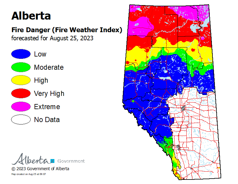
Above seasonal average temperatures continue. Please use caution in the the forested areas.
WEATHER
The forecasted temperature today is 27 degrees, a relative humidity of 30 percent with winds southwest 20 gusting 35 km/h.
HIGH LEVEL FOREST AREA | WILDFIRE SITUATION | AUGUST 25, 2023 AS OF 11:30 AM
There are 18 wildfires in the High Level Forest Area. Of these fires, one is classified as out of control (OC), 11 are being held (BH) and six are under control (UC). To see a map of the wildfires in the High Level Forest Area and across the province please click here.
Wildfires of interest;
HTZ001 | A wildfire from the Northwest Territories has entered the High Level Forest Area, northwest of Indian Cabins. The wildfire is classified as out of control and is approximately 20 km west of highway 35. This wildfire is approximately 33,280 hectares in size. Airtankers have established retardant lines to protect nearby infrastructure. There are four helicopters bucketing on this wildfire to extinguish hotspots. Due to poor visibility and difficult terrain crews have had limited access to the area.
There has been no significant movement of this wildfire in the last few days and there are no communities at risk at this time. For more information on this wildfire north of the Alberta border, visit the NWT Fire Info Facebook page or website. For any road closures please visit 511.alberta.ca
HWF030 | The Paskwa fire (HWF030) was detected on May 2, 2023. It extends along the south side of the Peace River from the community of Fox Lake into Wood Buffalo National Park and is approximately 8 km south of the community of Garden River. The wildfire is 96,582 hectares in size and is classified as under control (UC). Be extra cautious near burnt areas and avoid forested areas that have been recently affected by wildfire. Hazards remain from deep ash pits, burning peat and falling trees or branches, especially if windy.
THE BASSET COMPLEX | AUGUST 25, 2023 AS OF 11:30 AM
An Incident Management Team (IMT) is managing wildfires HWF058 within the High Level Forest Area.
HWF058 | This wildfire is located about 12 km northwest of the Paddle Prairie Metis Settlement boundary marker, where the Haig River meets the Chinchaga River. It is classified as out of control (OC) at 39,953 hectares.
In the past few days, activity has been reported on the west and northwest sides. Airtankers have worked to create containment lines by dropping retardant on the west side as there is difficult terrain for wildfire crews to extinguish hotspots in this area. Bucketing operations will continue on this flank as they work to extinguish a large hotspot.
Work continues along the southwest side, bucketing operations will continue to cool the area as crews work on hotspots. Dozer guard is being established on this side as heavy equipment moves north. The dozers have reached the halfway point and will continue to push north.
Resources
There are 88 firefighters working on the Basset Complex with 14 helicopters and heavy equipment.
Weather
Today the forecasted temperature is 28 degrees, a relative humidity of 25 percent with winds southwest 20 gusting 35 km/h.
THE LONG LAKE FIRE | AUGUST 25, 2023 AS OF 11:30 AM
An Incident Management Team (IMT) is managing fires HWF036 and HBZ003.
HWF036 | This wildfire is classified as being held (BH) at 188,333 hectares. Being held means that given current weather conditions and resources, the wildfire is not anticipated to grow past expected boundaries.
Firefighters and heavy equipment continue to strengthen and extend the containment lines in key areas to prevent the spread of the wildfire. Helicopters and crews continue to work to protect critical infrastructure on the west side. The northeast guard protecting the community of Chateh continues to hold.
Crews are working along the southwest edge of the perimeter as wildfire activity picked up in that area in the past few days. Helicopters will work alongside the crews to monitor and report smoke columns that continue to pop-up and will direct crews to that location for extinguishment.
We are asking the public, residents and industry to use extra caution around areas impacted by wildfire and to not walk near or into burnt areas. There are many hazards that are difficult to see, like deep burning ash pits, unstable trees that can fall because their roots have been burnt away, as well as other unknown dangers. Fallen trees on various roads have been reported. If travelling along these burnt areas, be aware and prepared in case these trees fall onto the road, as your vehicle could become entrapped.
HBZ003 | This fire continues to be active on the east and northeast sides with spread on the southeast flank. It has been confirmed that on the southeast side this fire has joined fire HWF036. Helicopters have been working the northeast and southeast side to slow the spread towards critical infrastructure in the area.
Resources
There are 38 firefighters and support staff working on this wildfire. Eight helicopters and heavy equipment are also supporting these operations. Additional helicopters and airtankers are available if required.
Weather
Today the forecasted temperature is 28 degrees, a relative humidity of 25 percent with winds southwest 20 gusting 35 km/h.
Stay away from active wildfire areas | For your safety and to ensure firefighters can do their job safely, please stay away from active wildfire areas. Your cooperation is essential.
Dangerous trees | Be extra cautious near burnt areas and avoid forested areas that have been recently affected by wildfire. Hazards remain from deep ash pits, burning peat and falling trees or branches, especially if windy.
Reporting wildfires | Please do not report smoke or flame from within an active wildfire area. Firefighters are diverted from essential tasks to respond to fires reported by the public. You may see smoke or flame within the existing boundary of a wildfire, this is normal.
Smoke | Lingering smoke may still be visible in some areas and in affected communities. Smoke inversions can trap air near the ground causing dangerous driving conditions and poor air quality. Please use extra caution when driving in smoky conditions, and take necessary precautions if you have smoke-related health concerns.
Drones | The use of recreational drones over wildfires in Alberta is dangerous, illegal and could result in a fine of up to $15,000* for putting aircraft and people at risk. Please give Alberta firefighters the space they need to do their jobs safely. *Transport Canada
.png?width=1201&height=629&name=WF_Social-images%20(8).png)
WILDFIRE INFORMATION
Download the Alberta Wildfire app today and get access to accurate, real-time information on wildfires in your area. You can also find information on fire advisories, restrictions and bans across the province and much more all on your mobile device. Available for Apple and Android.
Before heading out, please check albertafirebans.ca to determine whether there are any fire advisories, fire restrictions or fire bans in effect for your destination.
Subscribe to the High Level Forest Area Update to receive an email when new information is posted. Join the conversation on Facebook, Twitter or Instagram.
WILDFIRE LINKS AND TOOLS
Volunteers, equipment owners/operators or firefighters looking to assist with these wildfires or any of the wildfires within the province can contact EmergencySupportOffers@gov.ab.ca.
There are multiple EVACUATION ORDERS & ALERTS in the Province. Please visit Alberta Emergency Alerts or your community webpage for more information.
To see all the wildfires burning in Alberta click here.
WILDFIRE PREPAREDNESS | Learn how you can prepare yourself for a wildfire by clicking here.
High Level Forest Area | Information officer
Mobile: 780-841-9387
Email: victoria.ostendorf@gov.ab.ca