

NASA FIRMS fire information is an estimate and can often make a wildfire appear larger than it actually is — or appear to impact areas that it does not.
A fire ban remains in effect for the forest protection area of Alberta, including the High Level Forest Area.
The forest area may experience heavy smoke over communities at times. Contact 811 for wildfire and smoke-related health concerns.
If you see smoke or flame and suspect it's a wildfire, call 310-FIRE (3473).
This update is best viewed on a web browser or the AB Wildfire Status App | View previous High Level Forest Area Updates. Bold indicates new or important information.
-jpg.jpeg?width=900&height=1200&name=Conditions%20on%20Foggy%20Tower%20Rd%20while%20maritime%20crew%20did%20danger%20tree%20assessments%20July%2021_Melodie%20Roy%20(002)-jpg.jpeg)
Firefighters from PEI and New Brunswick conduct danger tree assessments during smoky conditions along Foggy Lookout Road on HWF061, which is part of the Semo Wildfire Complex (July 21, 2024). Fire crews, which include firefighters and a heavy equipment group from the Little Red River Cree Nation (LRRCN), continue to face tough working conditions on this complex.
EVACUATION ALERTS AND ORDERS
EVACUATION ORDERS are now in effect for all three LRRCN communities: John D'Or Prairie, Fox Lake and Garden River (July 20).
The Alberta Emergency Management Agency (AEMA) advises that Garden River is under an evacuation order, as of July 10. For more details, please visit https://www.alberta.ca/alberta-emergency-alert.aspx.
AEMA advises that the communities of John D'Or Prairie and Fox Lake are now also under an evacuation order (effective July 20). For more details, please visit https://www.alberta.ca/alberta-emergency-alert.aspx.
You can also follow Little Red River Cree Nation’s (LRRCN) Facebook page for updates at https://www.facebook.com/lrrcn or their website at https://lrrcn.ab.ca/
HIGH LEVEL FOREST AREA | WILDFIRE SITUATION
The wildfire danger in the High Level Forest Area is EXTREME. This means that forest fuels are extremely dry and pose a serious fire risk. Fast-spreading, high-intensity fires are likely, which are very difficult to control.
There are currently 35 wildfires burning in the High Level Forest Area. Of these, 11 are out of control, 12 are being held, and 12 are classified as under control. Two of these wildfires are carry-over fires from the 2023 season. There are also two wildfires along borders: one shared with B.C. and one with the N.W.T.
Since January 1, 2024, there have been 143 wildfires in the High Level Forest Area, burning a total of 237,951 hectares (ha).
NASA FIRMS Fire Information website is a great resource to give an approximate location of hotspots in an area, but cannot always be used to determine specifically where a wildfire is burning. The heat from smoke columns, reflections from water and other heat signatures will appear on the map. It's important to note that the data is based on a mathematical estimate (interpolation) and can often make a wildfire appear larger than it actually is.
You can view the location and statistics of these wildfires on our interactive map by following the active wildfire link. Visit our website to learn more about wildfire classifications.
HIGH LEVEL FOREST AREA | ACTIVE WILDFIRES OF INTEREST
WEATHER FORECAST
Today, a high of 30C and 40% relative humidity is expected in the forest area. Winds from the east at 15-20 km/h, gusting to 35 km/h, could move the wildfires towards the west. Thunder and rain showers with no significant rain are forecasted in the coming days.
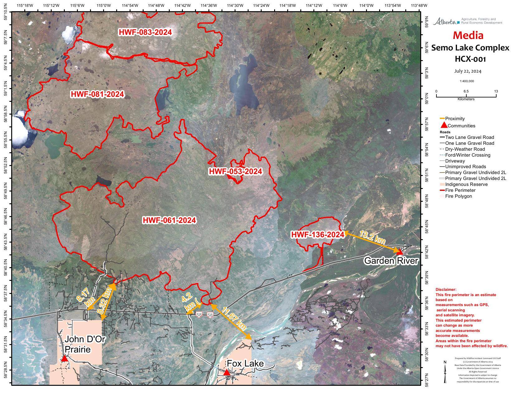
HCX001 – SEMO COMPLEX (HWF053, HWF061, HWF081, HWF083, HWF136, HWF141)
The Semo Wildfire Complex is located north of John D'Or Prairie, Garden River and Fox Lake. A few of the wildfires in this complex are located within Caribou Mountains Provincial Park, between the Ponton and the Wentzel River. An incident management team is in place on this wildfire complex, and response efforts of Alberta crews are being aided by firefighters from Alaska, Ontario, P.E.I. and New Brunswick.

A mobile water truck assists Little Red River Cree Nation (LRRCN) firefighters in holding HWF136, which is part of the Semo Wildfire Complex, to the north side of Highway 58 (July 22, 2024).
Heavy smoke in the area continues to shade wildfires from the sun, leading to higher relative humidity than predicted and allowing some good progress to be made. Conditions like this make air access to wildfires extremely difficult and impact fire operations, but they also contribute to a decrease in fire activity, which is why minimal growth continues to be observed on wildfires in the area. When smoke clears, we can expect to see increased and significant fire behaviour due to anticipated continuing hot, dry weather.
The structure protection unit was successful in running a test of the systems in place in Garden River earlier today and have joined other structure protection team members in John D’or Prairie. Installation of high-volume water lines and sprinklers began throughout John D’or yesterday and will continue today, which also includes FireSmart and community assessments.
To reinforce and increase the resilience of cabins north of Highway 58, a heavy equipment crew from Little Red River Cree Nation is creating dozer guards around each cabin. They began this work on Friday and will continue until the mission is completed.
HWF061 is a lightning-caused wildfire currently burning OUT OF CONTROL and was last estimated to be 96,217 hectares (ha). This wildfire is approximately 19 km northeast of John D'Or Prairie’s main community and approximately 12 km north of Fox Lake.
Crews yesterday completed the clearing work being done to danger trees along Foggy Tower Road and will start directly actioning the S-SW fire perimeter from the road today.
Heavy equipment operators keep up their work to remove fuel (trees, shrubs, vegetation, etc.) from the northern side of Highway 58, which will help increase the effectiveness of the highway as a containment line. Yesterday, they completed more than 5 km of line and, during night operations, they were able to finish another 3.5 km. This work will continue today.
HWF136 is currently burning OUT OF CONTROL at 4,763 ha in size. The wildfire is approximately 13 km northwest of Garden River and now reaches Highway 58. Optimal conditions were met for several unit crews and fire specialists to use hand ignition to complete tying this wildfire into Highway 58 and up along Fritz Creek. This ignition work removes available vegetation that a fire could have consumed as fuel, and, therefore, improves containment lines and reduces the likelihood of fire growth. Crews worked until late in the evening on this operation, which was then patrolled overnight by two teams from the structure protection unit.
Cabins in the area have been reinforced to increase protection against potential encroaching fire. More than 70 firefighters, including five Little Red River Cree Nation fire crews, will return to this wildfire today to begin extinguishing hot spots along the perimeter of the ignition lines.
Heavy equipment operators pushed in 5km of dozer guard yesterday along the southeast side of the wildfire. They’ll continue to work on this containment line tomorrow, with the goal of stopping at a wet feature east of the current fire perimeter. This containment line will be followed up with firefighters when completed.
HWF053 is currently burning OUT OF CONTROL. It's located directly above HWF061 and is estimated to be 709 ha in size. This wildfire was determined to have been caused by lightning.
Other fires on this complex are within or nearby Caribou Mountain Wildland Provincial Park. Most of these wildfires have been determined to be caused by lightning, but the newer ones’ causes remain under investigation. These fires will be monitored by fire personnel, with aircraft and further support as required. These wildfires include: HWF141, which is currently burning OUT OF CONTROL north of HWF061 and east of HWF081, covering approximately 2,038 ha; HWF081, which is OUT OF CONTROL and last estimated at 48,190 ha; and HWF083, which is OUT OF CONTROL at 32,840 ha.
Weather Forecast | Semo Complex
Today we can expect a high of 28 C, with a relative humidity (RH) of 30. Winds will be NE-SE at 15 km/hr, with occasional gusts of up to 30 km/hr. Tomorrow is predicted to reach a high of 26, with a RH of 40. A different weather system is expected to move in starting tomorrow, with larger, more variable winds anticipated. Winds will primarily be 10-15 km/hr tomorrow afternoon, with gusts between 35-45 km/hr. With the large increases in wind, we may see higher levels of fire behaviour and could expect to see significant fire growth tomorrow evening and into Wednesday.
There is a downtrend coming toward the end of the week with the forecast calling for cooler temperatures and some precipitation, which would help firefighting efforts.

Expand (click) to view the full public map of the Semo wildfire complex.
HCX002 - MELVIN RIVER COMPLEX | BISTCHO LAKE (part of HTZ001), HWF030, HWF047, HWF065, HWF072, HWF075 and HWF091
*The Amber River Complex has been blended into the Melvin River Complex.
An incident management team is responsible for the personnel and resources assigned to the Amber River Complex and its eight wildfires: Bistcho Lake (HTZ001), HWF030, HWF047, HWF065, HWF072, HWF074, HWF075 and HWF091). There are currently 69 personnel, 12 helicopters and five pieces of heavy equipment working on the wildfires within the Amber Complex. The wildfires in this complex do not currently threaten any communities.
HTZ001 is a mutual aid wildfire that originated in the border zone with the Northwest Territories (N.W.T.) in 2023. The BISTCHO LAKE section of HTZ001, which is estimated to cover an area of 95,000 ha, is actively burning on the NE and SE sides of Bistcho Lake, and its is currently burning OUT OF CONTROL. Some reassessments of structural protection are ongoing.
Please see NWT Wildfire Update Map and the South Slave SS009-24 Update for more information on their activities and wildfire status in the N.W.T. area.
HWF091, which is located NW of HWF065, is BEING HELD and is estimated to cover an area 1,602 ha. Monitoring continues on this wildfire for potential threats.
HWF072, which is approximately 60 km northwest of Chateh, is burning OUT OF CONTROL and is estimated to cover an area 7,282 ha in size. Some heli-bucketing is planned for today on west side of this wildfire (visibility permitting),
HWF065 is currently BEING HELD and is estimated to cover an area 23,092 ha in size. This wildfire is about 2 km southwest of Bistcho Lake and was determined to have been caused by lightning.
HWF047 is burning OUT OF CONTROL and is estimated to cover an area of 1,400 ha in size. This wildfire was determined to have been caused by lightning. Helicopters are assisting firefighters to contain this wildfire.
HWF030 is BEING HELD and is estimated to cover an area 3,221 ha in size. The cause of this fire is under investigation. Heavy equipment work continues on perimeter areas of this wildfire. Fire crews are set to be on the ground today working on expanding containment lines to 100 feet, which is aimed at moving areas from containment to controlled.
OTHER WILDFIRES IN THE HIGH LEVEL FOREST AREA
HWF133 is burning OUT OF CONTROL and estimated to be 336 ha in size. The cause of this fire is under investigation.
HWF121 is burning OUT OF CONTROL and estimated to be 6,790 ha in size. The cause of this fire is under investigation.
HWF115 is classified as BEING HELD, which means that given current weather conditions and resources, the wildfire is not anticipated to grow past expected boundaries. It's now estimated to be 15 ha in size. There are eight firefighters actioning this wildfire and reporting low intensity burning. Yesterday, six pieces of heavy equipment will began building contain line around the fire.
HWF102 is being held and estimated to be 6,958 ha in size. The fire was determined to have been caused by lightning.
To view these and other wildfires in the province, view our interactive map by following the active wildfire link.
PROVINCIAL WILDFIRE SITUATION (as of 10 a.m., July 22)
The fire danger is extreme throughout most of the province.
Since January 1, 2024 in the Forest Protection Area of Alberta, there have been 925 wildfires burning a total of 488,513 hectares (ha).
Last year, on this date, there were 885 wildfires that burnt a total of 2,160,124 ha. In the past five years on this date, an average of 742 wildfires had burnt an average of 624,448 ha.

Cities, towns, villages and summer villages, as well as federal lands (such as national parks), are exempt from this ban. These jurisdictions have the authority to issue their own bans and may have complementary bans in place.
Visit Alberta Fire Bans to see if a fire ban or restriction is in place in your area and learn what is prohibited and allowed under this ban.
The fire ban will remain in effect until conditions improve.
FIRE PERMITS REQUIRED
At this time, the High Level Forest Area is not issuing any permits. All existing permits are currently suspended.
High Level Forest Area | Permit Line: 780-926-5407. Stay informed of fire restrictions and fire bans in your area by checking Alberta Fire Bans.
DANGEROUS TREES | Be extra cautious near burnt areas and avoid forested areas that have been recently affected by wildfire. Hazards remain from deep ash pits, burning peat and falling trees or branches, especially if windy.
SMOKE | Lingering smoke may still be visible in some areas and in affected communities. Smoke inversions can trap air near the ground causing dangerous driving conditions and poor air quality. Please use extra caution when driving in smoky conditions. To see forecasted smoke, please visit FireSmoke.ca. If you have smoke related health concerns, please visit or contact Alberta 811.
ALBERTA HEALTH WILDFIRE RESOURCES | You can visit Alberta Health Services for information on how you or your loved ones can access resources related to wildfire impacts and smoke concerns.
DRONES | The use of recreational drones over wildfires in Alberta is dangerous, illegal and could result in a fine of up to $15,000* for putting aircraft and people at risk. Please give firefighters the space they need to do their jobs safely. *Transport Canada.
FireSmart is a national program that helps Canadians increase their resilience to wildfire. Whether you are a homeowner, resident, business, local government, or Indigenous community, you can take small steps with lasting impacts.
Vegetation management is the modification of wildland fuels for the purpose of mitigating the potential intensities and impact of wildfire. Vegetation management as a strategy for reducing wildfire hazard makes a lot of sense: wildfire requires fuel, in the form of vegetation, to burn. If we can change the fuel, we can change the wildfire's behaviour. For suggestions on landscaping tips, you can view the FireSmart Guide to Landscaping.
To learn more on how you can protect your home, visit FireSmart Alberta. For farm or acreages, you can download the Farm and Acreage FireSmart magazine.
WILDFIRE INFORMATION
- Visit firesmoke.ca to view smoke drifts in the area
- Call 811 for smoke related health concerns
- For evacuation information please visit https://www.alberta.ca/alberta-emergency-alert.aspx
- Download the Alberta Wildfire app today and get access to accurate, real-time information on wildfires in your area. You can also find information on fire advisories, restrictions and bans across the province and much more all on your mobile device. Available for Apple and Android.
- Before heading out, check the fire bans website or download the app to determine if there are any fire advisories, fire restrictions or fire bans in effect for your destination.
- Subscribe to the High Level Forest Area Update to receive an email when new information is posted. Join the conversation on Facebook, Twitter or Instagram.
- Missed an issue of the High Level Forest area Wildfire Update? You can find previous updates on our website.
- For evacuation orders and alerts in the Province visit Alberta Emergency Alerts or your community webpage for more information.
- For road closure information, visit Alberta 511 or download the app.
- To see all the wildfires burning in Alberta click here.
- Learn how you can prepare yourself for a wildfire with some tips and tricks on wildfire preparedness.


