

EVACUATION ORDERS are now in effect for all three LRRCN communities: John D'Or, Fox Lake and Garden River (July 20)
See below for links to the community (LRRCN) and AEMA web and Facebook pages.
A FIRE BAN remains in effect for the High Level River Area (see below for more information regarding fire bans — what is prohibited and what is allowed).
The forest area may experience heavy smoke over communities at times. Contact 811 for wildfire and smoke-related health concerns. If you see smoke or flame in the forest and suspect it's a wildfire, please call 310-FIRE (3473) immediately.
This update is best viewed on a web browser or the AB Wildfire Status App | View previous High Level Forest Area Updates. Bold indicates new or important information.
EVACUATION ALERTS AND ORDERS
The Alberta Emergency Management Agency (AEMA) advises that Garden River is under an evacuation order, as of July 10. For more details, please visit https://www.alberta.ca/alberta-emergency-alert.aspx.
AEMA advises that the communities of John D'Or Prairie and Fox Lake are now also under an evacuation order (effective July 20). For more details, please visit https://www.alberta.ca/alberta-emergency-alert.aspx.
You can also follow Little Red River Cree Nation’s (LRRCN) Facebook page for updates at https://www.facebook.com/lrrcn or their website at https://lrrcn.ab.ca/
HIGH LEVEL FOREST AREA | WILDFIRE SITUATION
The wildfire danger in the High Level Forest Area is EXTREME. This means that forest fuels are extremely dry and pose a serious fire risk. Fast-spreading, high-intensity fires are likely, which are very difficult to control.
There are currently 39 wildfires burning in the High Level Forest Area. Of these, 11 are out of control, 12 are being held, and 16 are classified as under control. Two of these wildfires are carry-over fires from the 2023 season. There are also two wildfires along borders: one shared with B.C. and one with the N.W.T.
Since January 1, 2024, there have been 143 wildfires in the High Level Forest Area, burning a total of 211,452 hectares (ha).
You can view the location and statistics of these wildfires on our interactive map by following the active wildfire link. Visit our website to learn more about wildfire classifications.
HIGH LEVEL FOREST AREA | ACTIVE WILDFIRES OF INTEREST
WEATHER FORECAST
The forecast calls for a high of 30 C with a relative humidity of 35 percent and winds from the East at 15 km/h. Little-to-no precipitation is in the forecast.
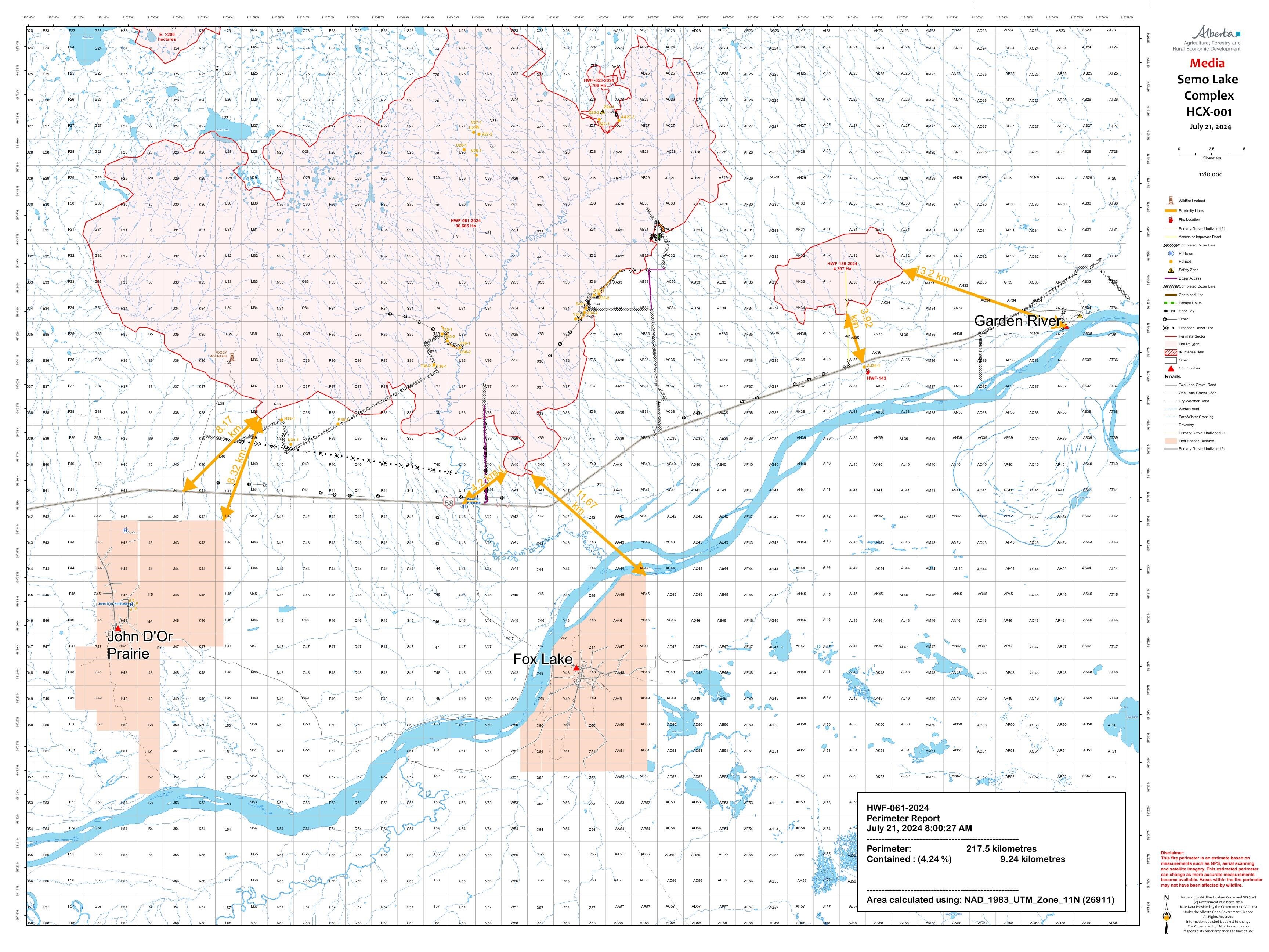
HCX001 – Semo Complex (HWF053, HWF061, HWF081, HWF083, HWF136, HWF141, HWF143)
The Semo Wildfire Complex is located north of John D'Or Prairie, Garden River and Fox Lake. A few of the wildfires in this complex are located within Caribou Mountains Provincial Park, between the Ponton and the Wentzel River. An incident management team is in place on this wildfire complex, and response efforts are being aided by firefighters from Alaska, Ontario, P.E.I. and New Brunswick.

Pioneer Peak Hotshots from Alaska and an Alberta Wildfire crew from Calgary conduct ignition operations along a containment line to secure a side of HWF136 in the Semo Wildfire Complex on July 21, 2024. These operations are conducted very carefully to burn specifically targeted fuel sources in designated areas, aimed at enhancing a containment line's effectiveness in limiting and containing a wildfire's growth.
A low ceiling yesterday, caused by heavy smoke in the area, led to cooler temperatures and higher relative humidity than predicted and allowed some progress to be made on a few wildfires within the Semo Complex. Conditions like this make air access to wildfires extremely difficult and impact fire operations, but they also contribute to a decrease in fire activity – this is why minimal growth was observed yesterday and overnight on wildfires in the area. Air operations are again limited this morning due to smoky conditions in the area. If smoke clears today, we can expect to see increased and significant fire behaviour due to hot, dry weather.
The structure protection unit on this complex will be running a test of the systems in place in Garden River today. As well, structure protection efforts continue in John D’or Prairie today, with high-volume water lines and sprinklers starting to be installed throughout the community.
HWF061 is a lightning-caused wildfire currently burning OUT OF CONTROL and was last estimated to be 96,217 hectares (ha). This wildfire is approximately 19 km northeast of John D'Or Prairie’s main community and approximately 15 km north of Fox Lake.
Firefighters travelled to Foggy Mountain Tower Lookout yesterday to do mop-up work and trying to establish a perimeter of extinguishment. This work includes finding and extinguishing hot spots and limit spread from any future encroaching fire. Other firefighters spent their day working along Foggy Tower Road to assess and fall danger trees to increase safety levels for future direct work.
By end of day yesterday, heavy equipment operators were successful at completing widening work to Foggy Tower Road, which will allow the road to be used as a containment line. Today, they will start working to remove fuel (trees, shrubs, vegetation, etc.) from the northern side of Highway 58, which will help increase the effectiveness of the highway as a containment line.
Fire specialists were able to fly late in the day yesterday and assess a couple areas of this wildfire from the air. The information gathered from the flights helped confirm and build on current strategies for managing HWF061.
HWF136 is currently burning OUT OF CONTROL at 3,397 ha in size. It is approximately 13 km northwest of Garden River and 3.9 km north of Highway 58. Fire specialists, along with a crew from Alaska, were able to complete some ignition yesterday, to assist in the eventual goal of tying this wildfire into Highway 58 and nearby water features. Ignition is carefully planned in advance and is only carried out if specific criteria and conditions are met. If optimal, ignition work will continue today. Cabins in the area are being reinforced to increase protection against any encroaching fire.
Heavy equipment operators are pushing a containment line in along the south-east side of the wildfire, working to tie the fire into a wet area east of the current fire perimeter.
Once these two tactics are complete, firefighters will work in from the perimeter of this wildfire to put out hot spots. This work will help strengthen and repurpose the area as a containment line for both this wildfire and HWF061.
HWF143 is now classified as UNDER CONTROL at approximately 3 ha.
HWF053 is currently burning OUT OF CONTROL. It's estimated to be 709 ha in size. This wildfire was determined to have been caused by lightning.
Other fires on this complex are within or nearby Caribou Mountain Wildland Provincial Park. Most of these wildfires have been determined to be caused by lightning, but the newer ones’ causes remain under investigation. These fires will be monitored by fire personnel, with aircraft and further support as required. These wildfires include: HWF141, which is currently burning OUT OF CONTROL north of HWF061 and east of HWF081, covering approximately 2,038 ha; HWF081, which is OUT OF CONTROL and last estimated at 48,190 ha; and HWF083, which is OUT OF CONTROL at 32,840 ha.
Weather Forecast | Semo Complex
Today, the temperature will be a high of 30 C, with relative humidity of 30. The wind is forecast to be SE-NE at 10-15 km/hr. There is again a very small chance of a trace amount of precipitation today. Hot and dry weather is still expected to continue for today and coming days, if smoke clears.

Firefighters work to enhance a containment line in the Semo Wildfire Complex (July 21, 2024)

Expand (click) to view the full public map of the Semo wildfire complex.
HCX002 - AMBER RIVER COMPLEX | BISTCHO LAKE (HTZ001), HWF030, HWF065, HWF072, HWF075 and HWF091
An incident management team is responsible for the personnel and resources assigned to the Amber River Complex and its seven wildfires: Bistcho Lake (HTZ001), HWF030, HWF065, HWF072, HWF074, HWF075 and HWF091). There are currently 69 personnel, 12 helicopters and five pieces of heavy equipment working on the wildfires within the Amber Complex. The wildfires in this complex do not currently threaten any communities.
Smoke
Smoke columns may be visible for residents in nearby communities into the afternoon and evening as these times are usually peak burning periods. Intense fire behaviour can be expected over the next several days due to dry conditions. Smoke drift may be seen in communities where it hasn’t previously been seen due to shifting wind directions.
HTZ001 is a mutual aid wildfire that originated in the border zone with the Northwest Territories (N.W.T.) in 2023. The BISTCHO LAKE section of HTZ001, which is estimated to cover an area of 95,000 ha, is actively burning on the NE and SE sides of Bistcho Lake, and its is currently burning OUT OF CONTROL. Some reassessments of structural protection are ongoing.
Please see NWT Wildfire Update Map and the South Slave SS009-24 Update for more information on their activities and wildfire status in the N.W.T. area.
HWF030 is BEING HELD and is estimated to cover an area 3,221 ha in size. The cause of this fire is under investigation. Firefighters continue their work along the fires edge and in priority areas to improve containment lines.
HWF065 is currently BEING HELD and is estimated to cover an area 23,092 ha in size. This wildfire is about 2 km southwest of Bistcho Lake and was determined to have been caused by lightning.
HWF072, which is approximately 60 km northwest of Chateh, is burning OUT OF CONTROL and is estimated to cover an area 7282 ha in size.
HWF075 is UNDER CONTROL and is estimated to cover an area 3 ha in size. This wildfire was determined to have been caused by lightning.
HWF091, which is located NW of HWF065, is BEING HELD and is estimated to cover an area 1602 ha. Monitoring continues on this wildfire for potential threats.
OTHER FIRES IN THE HIGH LEVEL FOREST AREA
HWF133 is burning OUT OF CONTROL and is estimated to cover an area 336 ha in size. The cause of this fire is under investigation.
HWF047 is burning OUT OF CONTROL and is estimated to cover an area of 1400 ha in size. This wildfire was determined to have been caused by lightning. Helicopters are assisting firefighters to contain this wildfire.
To view these and other wildfires in the province, view our interactive map by following the active wildfire link.
PROVINCIAL WILDFIRE SITUATION (as of 10 a.m., July 21)
The fire danger is very high to extreme throughout most of the province.
Since January 1, 2024 in the Forest Protection Area of Alberta, there have been 911 wildfires burning a total of 452,313 hectares (ha).
Last year, on this date, there were 875 wildfires that burnt a total of 2,160,119 ha. In the past five years on this date, an average of 739 wildfires had burnt an average of 624,444 ha.
A fire ban is in effect, as of July 10, in the entire Forest Protection Area of Alberta, including the High Level Forest Area, due to hot and dry conditions.
Cities, towns, villages and summer villages, as well as federal lands (such as national parks), are exempt from this ban. These jurisdictions have the authority to issue their own bans and may have complementary bans in place.
Visit Alberta Fire Bans to see if a fire ban or restriction is in place in your area.
Under this fire ban:
- All fire permits are suspended or cancelled.
- No new fire permits will be issued.
- Some allowances can be made for essential agricultural and industrial burning, if approved by a forest officer.
Prohibited:
- All outdoor wood fires, including wood campfires on public land, private land, designated campgrounds, and backyard firepits
- Barbeque charcoal briquettes
- Fireworks and exploding targets
Allowed:
- Propane/ natural gas-powered appliances
- Indoor wood fires inside a structure (such as a facility, building, tent or RV) and contained within a device with a chimney and spark arrestor
- Open flame oil devices (such as deep fryers and tiki torches). All devices must be CSA approved and used per manufacturer’s standards.
If you see a wildfire, report it immediately by calling 310-FIRE.
The fire ban will remain in effect until conditions improve.
FIRE PERMITS REQUIRED
At this time, the High Level Forest Area is not issuing any permits. All existing permits are currently suspended.
High Level Forest Area | Permit Line: 780-926-5407. Stay informed of fire restrictions and fire bans in your area by checking Alberta Fire Bans.
DANGEROUS TREES | Be extra cautious near burnt areas and avoid forested areas that have been recently affected by wildfire. Hazards remain from deep ash pits, burning peat and falling trees or branches, especially if windy.
SMOKE | Lingering smoke may still be visible in some areas and in affected communities. Smoke inversions can trap air near the ground causing dangerous driving conditions and poor air quality. Please use extra caution when driving in smoky conditions. To see forecasted smoke, please visit FireSmoke.ca. If you have smoke related health concerns, please visit or contact Alberta 811.
ALBERTA HEALTH WILDFIRE RESOURCES | You can visit Alberta Health Services for information on how you or your loved ones can access resources related to wildfire impacts and smoke concerns.
DRONES | The use of recreational drones over wildfires in Alberta is dangerous, illegal and could result in a fine of up to $15,000* for putting aircraft and people at risk. Please give firefighters the space they need to do their jobs safely. *Transport Canada.
FireSmart is a national program that helps Canadians increase their resilience to wildfire. Whether you are a homeowner, resident, business, local government, or Indigenous community, you can take small steps with lasting impacts.
Vegetation management is the modification of wildland fuels for the purpose of mitigating the potential intensities and impact of wildfire. Vegetation management as a strategy for reducing wildfire hazard makes a lot of sense: wildfire requires fuel, in the form of vegetation, to burn. If we can change the fuel, we can change the wildfire's behaviour. For suggestions on landscaping tips, you can view the FireSmart Guide to Landscaping.
To learn more on how you can protect your home, visit FireSmart Alberta. For farm or acreages, you can download the Farm and Acreage FireSmart magazine.
WILDFIRE INFORMATION
- Visit firesmoke.ca to view smoke drifts in the area
- Call 811 for smoke related health concerns
- For evacuation information please visit https://www.alberta.ca/alberta-emergency-alert.aspx
- Download the Alberta Wildfire app today and get access to accurate, real-time information on wildfires in your area. You can also find information on fire advisories, restrictions and bans across the province and much more all on your mobile device. Available for Apple and Android.
- Before heading out, check the fire bans website or download the app to determine if there are any fire advisories, fire restrictions or fire bans in effect for your destination.
- Subscribe to the High Level Forest Area Update to receive an email when new information is posted. Join the conversation on Facebook, Twitter or Instagram.
- Missed an issue of the High Level Forest area Wildfire Update? You can find previous updates on our website.
- For evacuation orders and alerts in the Province visit Alberta Emergency Alerts or your community webpage for more information.
- For road closure information, visit Alberta 511 or download the app.
- To see all the wildfires burning in Alberta click here.
- Learn how you can prepare yourself for a wildfire with some tips and tricks on wildfire preparedness.

