A FIRE BAN IS NOW IN EFFECT FOR THE HIGH LEVEL FOREST AREA.
Garden River is under an evacuation order as of July 10, 2024.
The forest area may experience heavy smoke over communities at times. Contact 811 for wildfire and smoke-related health concerns.
If you see smoke or flame in the forest and suspect it's a wildfire, call 310-FIRE (3473) immediately.

A fire ban is in effect as of July 10 in the entire Forest Protection Area of Alberta, including the High Level Forest Area, due to hot and dry conditions.
Cities, towns, villages and summer villages, as well as federal lands (such as national parks), are exempt from this ban. These jurisdictions have the authority to issue their own bans and may have complementary bans in place.
Visit Alberta Fire Bans to see if a fire ban or restriction is in place in your area.
Under this fire ban:
- All fire permits are suspended or cancelled.
- No new fire permits will be issued.
- Some allowances can be made for essential agricultural and industrial burning, if approved by a forest officer.
Prohibited:
- All outdoor wood fires, including wood campfires on public land, private land, designated campgrounds, and backyard firepits
- Barbeque charcoal briquettes
- Fireworks and exploding targets
Allowed:
- Propane/ natural gas-powered appliances
- Indoor wood fires inside a structure (such as a facility, building, tent or RV) and contained within a device with a chimney and spark arrestor
- Open flame oil devices (such as deep fryers and tiki torches). All devices must be CSA approved and used per manufacturer’s standards.
If you see a wildfire, report it immediately by calling 310-FIRE.
The fire ban will remain in effect until conditions improve.
HIGH LEVEL FOREST AREA | WILDFIRE SITUATION
The wildfire danger in the High Level Forest Area is now EXTREME. This means that forest fuels are extremely dry and pose a very serious fire risk. Fast-spreading, high-intensity fires are likely, which are very difficult to control.
There are currently 34 wildfires burning in the High Level Forest Area. Of these, 10 are out of control, 12 are being held, and 12 are classified as under control. Two of these wildfires are carry-over fires from the 2023 season. There are also two wildfires along borders: one shared with B.C. and one with the N.W.T.
Since January 1, 2024, there have been 120 wildfires in the High Level Forest Area, burning a total of 138,107 hectares (ha).
You can view the location and statistics of these wildfires on our interactive map by following the active wildfire link. Visit our website to learn more about wildfire classifications.
HIGH LEVEL FOREST AREA | ACTIVE WILDFIRES OF INTEREST
WEATHER FORECAST Today, we expect a high of 23C with 30 percent relative humidity (RH) and winds from the northwest at 15 km/h.
Tomorrow, we expect a high of 24C with 30-50 percent RH and winds from the northwest at 15-20 km/h.
HWF102 is currently burning OUT OF CONTROL and is estimated to be 5,882 ha in size. The wildfire is located 34 km southeast of Tall Cree South and 38 km east of Wadlin Lake. It was caused by lightning.
HWF121 is currently burning OUT OF CONTROL and is estimated to be 300 ha. The wildfire is located 17 km east of highway 88 and 56 km south-southeast of Tall Cree.
HWF123 is currently burning OUT OF CONTROL and is estimated to be 0.5 ha. Three helicopters are working to contain and extinguish the fire.
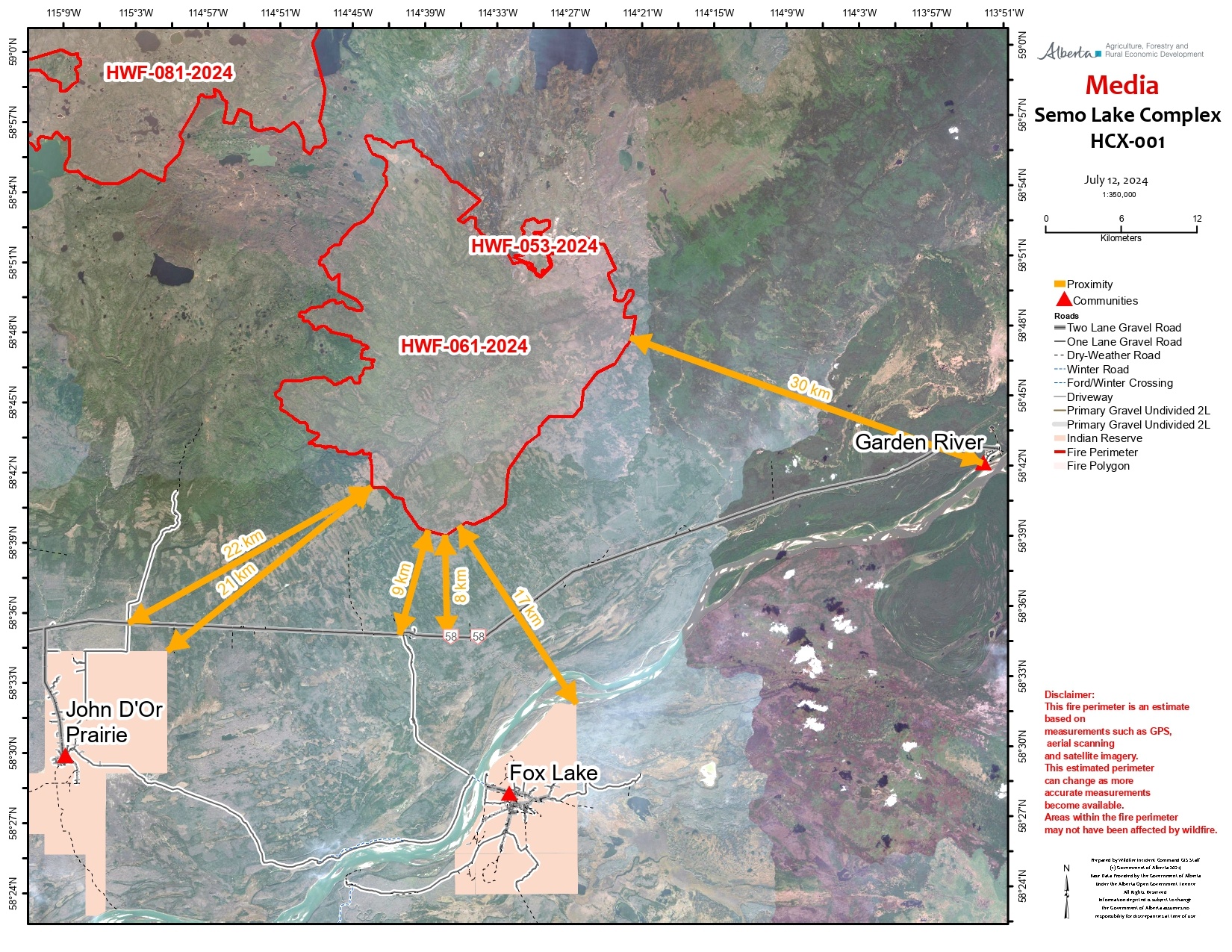
HCX001 - SEMO WILDFIRE COMPLEX | HWF053, HWF061, HWF081, HWF083
The Semo Wildfire Complex is located north of John D'Or Prairie, Garden River and Fox Lake. It includes the Caribou Mountains P.P, between the Ponton and the Wentzel River. This wildfire is currently being overseen by an incident management team. Additional resources have been requested and will be arriving in the coming days.
Today, the weather forecast is calling for temperatures of 20C with a relative humidity of 40% with winds out of the west at 20 km/h gusting 40 km/h. These lower temperatures are due to the cold front moving through the area yesterday afternoon.

Early morning smoke activity on the Semo Complex (July 12, 2024).
HWF053 is currently burning OUT OF CONTROL and is estimated to be 641 ha in size. The wildfire remains under investigation.
HWF061 is currently burning OUT OF CONTROL 21 km northeast of Jon D'or, 17 km north of Fox Lake and 30 km northwest of Garden River. The closest part of the wildfire is approximately 8 km to highway 58.
The wildfire is now estimated to be 46,039 ha in size and caused by lightning. Most of the activity on this fire was on the west side yesterday. The cooler weather observed this morning will allow firefighters some time to establish containment lines when the fire behaviour is low.
Heavy equipment is working on the southeast side to build containment lines and crews will support the operators by extinguishing hotspots as they move north. Operators on the west side are building extra dozer guard lines and will move to priority areas when complete. Crews are seeing deep burning in some areas, and they will have to use pumps and hose along with hand tools to dig deep and extinguish the hotspots. Additional dozer guards are being created for firefighters and equipment for safety as needed. Helicopters will continue to bucket along priority areas along the south perimeter to support ground crews.
Smoke columns will likely be visible from communities when hot, dry and windy conditions are present. Today's cooler temperatures will give some relief to fire intensity in the morning.
HWF081 is OUT OF CONTROL at 40,828 ha. The wildfire was most active on the west side yesterday. Firefighters and aircraft will monitor this fire and provide support when needed.
HWF083 is OUT OF CONTROL at 29,930 ha continues to grow under current conditions. At this time, no significant growth has been observed. Firefighters will continue to monitor this wildfire and provide support when needed. All of these wildfires are within the Caribou Mountain Wildland P.P. and have been caused by lightning. These wildfires are located approximately 35-40 km north of John D'Or Prairie.
There are 210 firefighters and support staff, eight helicopters and 24 pieces of heavy equipment assigned to the Semo Complex. Additional resources are on their way to support firefighting activities.
EVACUATION ALERTS AND ORDERS
Garden River is under an evacuation order as of 12:00 p.m. July 10, 2024. For further information related to evacuations, please visit Alberta Emergency Alert webpage or download the app.
You can also follow Little Red River Cree Nation’s Facebook page or their website.
HCX002 - AMBER RIVER COMPLEX | HWF030, HWF072, HWF075, HWF076, HWF089, HWF101
An incident management team is responsible for the personnel and resources assigned to the Amber River Complex and its six wildfires. There are currently 110 firefighters, nine helicopters and eight pieces of heavy equipment working on the wildfires within the Amber Complex. The wildfires in this complex do not currently threaten any communities.
HWF072 is burning OUT OF CONTROL and is now estimated to cover an area 3,700 ha in size after moderate growth overnight. This wildfire, which is approximately 78 km northwest of Chateh and about 60 km west of Zama City, does not currently pose a threat to any communities. This wildfire was caused by lightning.
Airtankers are being used when conditions permit and as opportunities arise. Heavy equipment, which has been delayed by the difficulty in reaching this wildfire on the ground, is expected to arrive on site today. Once there, heavy equipment operators will support aerial fire suppression activities and firefighters on the ground.
Smoke has impacted visibility and the use of aircraft has been limited. Poor visibility has also led to reduced on-the-ground firefighter activity at times.
HTZ001 is a mutual aid wildfire that originated in the border zone with the Northwest Territories (N.W.T.) in 2023. The Alberta portion of this fire, south of the border, is now classified as OUT OF CONTROL.
BISTCHO LAKE section of HTZ001 is actively burning on the northeast and southeast of Bistcho Lake. Firefighters and heavy equipment are working to build containment line to reduce the spread towards the east. Structure protection crews are working in the area, maintaining equipment and assessing the situation. The wildfire showed little fire activity overnight and received precipitation this morning.
Please see NWT Wildfire Update Map and the South Slave SS009-24 Update for more information on their activities and wildfire status in the N.W.T. area.
To view these and other wildfires in the province, view our interactive map by following the active wildfire link.
PROVINCIAL WILDFIRE SITUATION (as of 10 a.m., July 12)
The fire danger is very high to extreme throughout most of the province and moderate to high in the far north.
Since January 1, 2024 in the Forest Protection Area of Alberta, there have been 732 wildfires burning a total of 254,327 hectares (ha).
Last year, on this date, there were 844 wildfires that burnt a total of 2,153,851 ha. In the past five years on this date, an average of 675 wildfires had burnt an average of 225,575 ha.
DANGEROUS TREES | Be extra cautious near burnt areas and avoid forested areas that have been recently affected by wildfire. Hazards remain from deep ash pits, burning peat and falling trees or branches, especially if windy.
SMOKE | Lingering smoke may still be visible in some areas and in affected communities. Smoke inversions can trap air near the ground causing dangerous driving conditions and poor air quality. Please use extra caution when driving in smoky conditions. To see forecasted smoke, please visit FireSmoke.ca. If you have smoke related health concerns, please visit or contact Alberta 811.
ALBERTA HEALTH WILDFIRE RESOURCES | You can visit Alberta Health Services for information on how you or your loved ones can access resources related to wildfire impacts and smoke concerns.
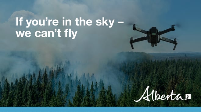
DRONES | The use of recreational drones over wildfires in Alberta is dangerous, illegal and could result in a fine of up to $15,000* for putting aircraft and people at risk. Please give firefighters the space they need to do their jobs safely. *Transport Canada.
FIRE PERMITS REQUIRED
At this time, the High Level Forest Area is not issuing any permits. All existing permits are currently suspended.
High Level Forest Area | Permit Line: 780-926-5407. Stay informed of fire restrictions and fire bans in your area by checking Alberta Fire Bans.
FireSmart is a national program that helps Canadians increase their resilience to wildfire. Whether you are a homeowner, resident, business, local government, or Indigenous community, you can take small steps with lasting impacts.
Vegetation management is the modification of wildland fuels for the purpose of mitigating the potential intensities and impact of wildfire. Vegetation management as a strategy for reducing wildfire hazard makes a lot of sense: wildfire requires fuel, in the form of vegetation, to burn. If we can change the fuel, we can change the wildfire's behaviour. For suggestions on landscaping tips, you can view the FireSmart Guide to Landscaping.
To learn more on how you can protect your home, visit FireSmart Alberta. For farm or acreages, you can download the Farm and Acreage FireSmart magazine.
WILDFIRE INFORMATION
- Download the Alberta Wildfire app today and get access to accurate, real-time information on wildfires in your area. You can also find information on fire advisories, restrictions and bans across the province and much more all on your mobile device. Available for Apple and Android.
- Before heading out, check the fire bans website or download the app to determine if there are any fire advisories, fire restrictions or fire bans in effect for your destination.
- Subscribe to the High Level Forest Area Update to receive an email when new information is posted. Join the conversation on Facebook, Twitter or Instagram.
- Missed an issue of the High Level Forest area Wildfire Update? You can find previous updates on our website.
- For evacuation orders and alerts in the Province visit Alberta Emergency Alerts or your community webpage for more information.
- For road closure information, visit Alberta 511 or download the app.
- For smoke forecasts and locations tools, visit the Fire Smoke website.
- To see all the wildfires burning in Alberta click here.
- Learn how you can prepare yourself for a wildfire with some tips and tricks on wildfire preparedness.