The wildfire danger in the High Level Forest Area remains VERY HIGH.
Ensure you fully extinguish your campfire until the ashes are cool to the touch and never leave it unattended. Sparks from your campfire could land in nearby dry vegetation and start a wildfire.
If you see smoke or flame in the forest and suspect it's a wildfire, call 310-FIRE (3473) to report it.

Bertie Beaver had the opportunity to stop by and visit folks at the High Level Canada Day celebration. (July 1, 2024)
A fire advisory is in effect for the High Level Forest Area. Under this advisory:
- Existing fire permits are valid but extension requests may not be granted. Permit holders must follow the safe burning conditions outlined on the fire permit; and
- New fire permits will be issued on a case-by-case basis, for essential burning only.
Permitted:
- Safe wood campfires
- Backyard fire pits
- Portable propane fire pits
- Gas or propane stoves and barbecues
- Catalytic or infrared style heaters
Prohibited:
- Any burning without a valid fire permit, other than a campfire, is prohibited.
To learn more about the Alberta Fire Ban System, check out our video or visit Alberta Fire Bans.
HIGH LEVEL FOREST AREA | WILDFIRE SITUATION
The wildfire danger in the High Level Forest Area remains VERY HIGH. This means that high-intensity fire is expected and likely to spread to treetops. Fire is expected to start easily and to challenge suppression efforts.
There are currently 16 wildfires burning in the High Level Forest Area. Six are out of control, four are being held, four are classified as under control. Two of these wildfires are carry-over fires from the 2023 season. Additionally, there are two wildfires along borders: one shared with B.C. and one with the N.W.T.
Since January 1, 2024, there have been 62 wildfires in the High Level Forest Area, burning a total of 6,367 hectares (ha).
Visit our website to learn more about wildfire classifications.
You can view the location and statistics of these wildfires on our interactive map by following the active wildfire link.
HIGH LEVEL FOREST AREA | ACTIVE WILDFIRES OF INTEREST
WEATHER FORECAST | The wildfires in the High Level Forest Area received some precipitation last night and again this evening, giving some relief in certain areas.
Today, the area experienced max temperatures of near 30 C and low relative humidity. Smoke settled over some of the wildfires and the forest area. The smoke fortunately shades the sun from the wildfire and reduces its activity however this can make additional challenges for firefighters and aircraft.
Tomorrow, max temps of 24 C and relative humidity of 65% are forecasted for the area. Winds from the northwest 10-15 km/h are expected to shift early in the afternoon to north northeast 15-20 km/h gusting to 35. Near 8 p.m., the winds are expected to shift again from the northwest 10 km/h. An expected 4-8 mm of rain would help dampen fire behaviour in the forest area. These storm cells could also bring lightning and start new wildfires.
HWF030 (Amber River - Near Zama) is currently BEING HELD which means that given current weather conditions and resources, this wildfire is not anticipated to grow past its expected boundaries. The wildfire is located approximately 8.5 km southwest of Zama City and estimated to be 3,200 hectares (ha). The wildfire remains under investigation.
There are 155 firefighters and support staff working on this wildfire, along with nine helicopters and heavy equipment operators. Airtankers remain available, if required. Firefighters, aircraft and heavy equipment are searching for and extinguishing hotspots.
Firefighters will continue our use of night-vision equipped (NVIS) helicopters overnight when available. They have the capacity to use infrared technology to monitor fire behavior and support operational planning with their assessments.
HWF044 is currently OUT OF CONTROL. The wildfire is located approximately 40 km north east of the Town of High Level (near Ponton) and estimated to be 275 ha. The wildfire does not pose a threat to any community at this time. The cause is under investigation. There are 33 firefighters and five helicopters associated to this wildfire.
Firefighters assisted with helicopters continue to build containment line on the north side of the wildfire. Airtankers were not able to assist today due to smoke and visibly issues.
HWF047 (Melvin River) is currently burning OUT OF CONTROL approximately 40 km north-northeast of the town of High Level and 25 km east of Highway 35. The wildfire is now estimated to be 1,300 ha in size. The wildfire does not pose a threat to any community at this time and the cause is under investigation.
There are 81 firefighters, five helicopters along with heavy equipment associated to this wildfire. An incident management team has arrived in the forest area and has taken over the management of this wildfire today. Airtankers are available to assist firefighters when possible and night-vision helicopters are assisting.
Today, firefighters continued to work on the south side, supported by aircraft and airtankers. They've be working on key areas of the wildfire to prevent the spread towards communities. Heavy equipment are being established, the wet ground is making it challenging for them to reach the fire perimeter.
HWF053 is currently burning OUT OF CONTROL approximately 40 km north east of John D'or Prairie and 155 km east northeast of the Town of High Level. It's estimated to be 525 ha in size. There is no threat to any community at this time, the wildfire remains under investigation.
Airtankers worked on the south side of the wildfire again today, making good progress on suppressing fire activity. The wildfire will be receiving heavy equipment and firefighters to begin building containment lines. A night-vision helicopter is planned to assist this wildfire again tonight.
HWF061 is currently burning OUT OF CONTROL 40 km northeast of Jon D'or and 40 km north of Fox Lake. The fire does not pose a threat to any community. The wildfire is estimated to be 300 ha in size and caused by lightning. No significant growth was observed this evening as fire behaviour has been suppressed by smoke.

HTZ001 (Cameron Hills) is a mutual aid wildfire that originated in the border zone with the Northwest Territories (N.W.T.) in 2023. The Alberta portion of this fire, south of the border, is now classified as BEING HELD, which means that the wildfire is not expected to grow past its current boundaries.
On the Alberta side, this wildfire (HTZ001) is located near Indian Cabins, just south of the N.W.T. border. This recent burn within the High Level Forest Area covers an estimated 30,520 hectares ha.
Given our success in managing this wildfire to date, the assigned Alberta Wildfire incident management team (IMT), which had been in place for about a month, has departed — leaving a reduced number of firefighters, support staff and aircraft on scene (along with some heavy equipment), as we continue to monitor this wildfire, extinguishing any hot spots found along the perimeters.
The aim of protecting critical infrastructure along Highway 35, including utilities and Indian Cabins, remains, and we will continue to work closely with our industry partners and N.W.T. counterparts to contain and control this wildfire (HTZ001).
Please see NWT Wildfire Update Map and the South Slave SS009-24 Update for more information on their activities and wildfire status in the N.W.T. area.
This wildfire may cause highway closures, visit Alberta 511 or download the app for up-to-date information.
While supporting other wildfires in the forest area, the night-vision helicopter spotted HWF060 last night and was about to contain the spread (July 1, 2024). **This video can only be viewed on a web browser.
PROVINCIAL WILDFIRE SITUATION (as of 10 a.m., July 1)
The fire danger is high to extreme in the northern part of the province. It is moderate to high in the central boreal and the agricultural zone, with pockets of low fire danger. The fire danger is low along the Rocky Mountains.
Since January 1, 2024 in the Forest Protection Area of Alberta, there have been 511 wildfires burning a total of 33,183 ha.
Last year, on this date, there was 769 wildfires that burnt a total of 1,988,237 ha. In the past 5 years on this date, an average of 594 wildfires had burnt an average of 569,309 ha.
DANGEROUS TREES | Be extra cautious near burnt areas and avoid forested areas that have been recently affected by wildfire. Hazards remain from deep ash pits, burning peat and falling trees or branches, especially if windy.
SMOKE | Lingering smoke may still be visible in some areas and in affected communities. Smoke inversions can trap air near the ground causing dangerous driving conditions and poor air quality. Please use extra caution when driving in smoky conditions. To see forecasted smoke, please visit FireSmoke.ca. If you have smoke related health concerns, please visit or contact Alberta 811.
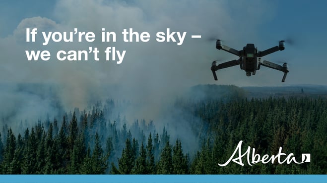
DRONES | The use of recreational drones over wildfires in Alberta is dangerous, illegal and could result in a fine of up to $15,000* for putting aircraft and people at risk. Please give firefighters the space they need to do their jobs safely. *Transport Canada.
FIRE PERMITS REQUIRED
All burning within the Forest Protection Area of Alberta requires a burn permit, with the exception of a campfire. At this time, the High Level Forest Area is issuing burn permits on a case-by-case basis.
High Level Forest Area | Permit Line: 780-926-5407. Stay informed of fire restrictions and fire bans in your area by checking Alberta Firebans.
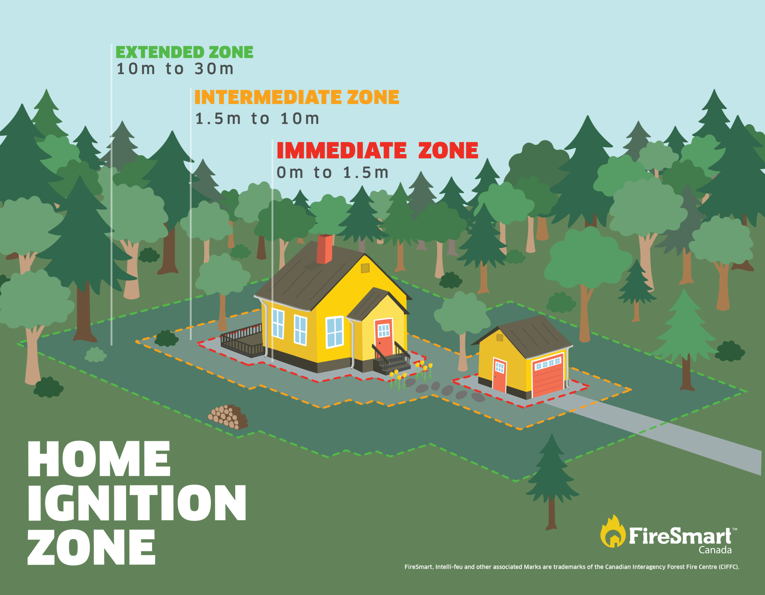
FireSmart is a national program that helps Canadians increase their resilience to wildfire. Whether you are a homeowner, resident, business, local government, or Indigenous community, you can take small steps with lasting impacts.
Homes and buildings ignite because of the materials, condition, and everything that surrounds them. The area within 30 m of the home is called the Home Ignition Zone. Within it are three priority areas, each requiring specific actions. Start by reducing your risk in the Immediate Zone and work your way outward.
To learn more on how you can protect your home, visit FireSmart Alberta. For farm or acreages, you can download the Farm and Acreage FireSmart magazine.
WILDFIRE INFORMATION
Download the Alberta Wildfire app today and get access to accurate, real-time information on wildfires in your area. You can also find information on fire advisories, restrictions and bans across the province and much more all on your mobile device. Available for Apple and Android.
Before heading out, check the fire bans website or download the app to determine if there are any fire advisories, fire restrictions or fire bans in effect for your destination.
Subscribe to the High Level Forest Area Update to receive an email when new information is posted. Join the conversation on Facebook, Twitter or Instagram.
Missed an issue of the High Level Forest area Wildfire Update? You can find previous updates on our website.
For evacuation orders and alerts in the Province visit Alberta Emergency Alerts or your community webpage for more information.
For road closure information, visit Alberta 511 or download the app.
For smoke forecasts and locations tools, visit the Fire Smoke website.
To see all the wildfires burning in Alberta click here.
Learn how you can prepare yourself for a wildfire with some tips and tricks on wildfire preparedness.