

The High Level Forest Area fire danger remains high due to dry conditions that will not improve until the area receives significant rainfall.
If you see smoke or flame in the forest and suspect it's a wildfire, call 310-FIRE.

- New heavy fuel fire permits may be requested and will be evaluated on a case-by-case basis.
- Burn barrel permits can be requested and burn barrel permits that were issued in 2023 are active again.
- Backyard fire pits
- Portable propane fire pits
- Gas or propane stoves and barbecues
- Catalytic or infrared-style heaters
Stay away from active wildfire areas | For your safety and to ensure firefighters can do their job safely, please stay away from active wildfire areas. Your cooperation is essential.
Dangerous trees | Be extra cautious near burnt areas and avoid forested areas that have been recently affected by wildfire. Hazards remain from deep ash pits, burning peat and falling trees or branches, especially if windy.
Reporting wildfires | Please do not report smoke or flame from within an active wildfire area. Firefighters are diverted from essential tasks to respond to fires reported by the public. You may see smoke or flame within the existing boundary of a wildfire, this is normal.
Smoke | Lingering smoke may still be visible in some areas and in affected communities. Smoke inversions can trap air near the ground causing dangerous driving conditions and poor air quality. Please use extra caution when driving in smoky conditions, and take necessary precautions if you have smoke-related health concerns.
Drones | The use of recreational drones over wildfires in Alberta is dangerous, illegal and could result in a fine of up to $15,000* for putting aircraft and people at risk. Please give Alberta firefighters the space they need to do their jobs safely. *Transport Canada
WEATHER
The forecasted temperature today is 24 degrees, a relative humidity of 40 percent with southwest winds 20 km/h gusting to 40 km/h.
HIGH LEVEL FOREST AREA | WILDFIRE SITUATION | AUGUST 16, 2023 AS OF 2:00 PM
There are 17 wildfires in the High Level Forest Area. Of these fires, one is classified as out of control (OC), 10 are being held (BH) and six are under control (UC). To see a map of the wildfires in the High Level Forest Area and across the province please click here.
WILDFIRES OF INTEREST
HWF112 | This fire is located approximately 32 km north of highway 58, east of Wentzel Lake. This fire is classified as being held (BH) at a last recorded size of 32,158 hectares. This fire is being monitored by firefighters. There are no communities at risk at this time.
HWF064 | This fire was detected June 9, 2023. This fire is classified as under control (UC) with a last recorded size of 6,175 hectares. The fire is located approximately 10 km northwest of Zama City. Firefighters are monitoring this wildfire and will respond as needed.
HWF030 | THE PASKWA FIRE
The Paskwa fire was detected on May 2, 2023. It extends along the south side of the Peace River from the community of Fox Lake into Wood Buffalo National Park and is approximately 8 km south of the community of Garden River. The wildfire is 96,582 hectares in size and is classified as under control (UC).
Be extra cautious near burnt areas and avoid forested areas that have been recently affected by wildfire. Hazards remain from deep ash pits, burning peat and falling trees or branches, especially if windy.
NORTHWEST TERRITORIES WILDFIRE
HTZ001 | A wildfire from the Northwest Territories has entered the High Level Forest Area northwest of Indian Cabins. For more information, visit the NWT Fire Info Facebook page or website.
You can also call the wildfire information line at 1-867-445-5484 to speak with an Information Officer.
For any road closures please visit 511.alberta.ca
THE OWL COMPLEX | AUGUST 16, 2023 AS OF 2:00 PM
The High Level Forest Area is managing wildfires HWF072, HWF138, HWF083, HWF087, HWF092, and HWF142.
HWF072 | This fire is classified as under control (UC) at 30,123 hectares. The fire is approximately 14 km southwest of the South Tall Cree boundary at highway 88.
This week, crews will continue to search for and extinguish hotspots near Wadlin Lake and the northern perimeter of the wildfire. Reclamation of dozer guards in areas where there's no concern for re-ignition is being planned and will begin in the coming weeks when conditions allow.
HWF083 | This fire is classified as being held (BH) at 13,700 hectares. It is located approximately 34 km southeast of the South Tall Cree boundary at the Wabasca River. No communities are currently at risk. Firefighters are monitoring this fire.
HWF087 | This fire is classified as being held (BH) at 12,508 hectares. This fire is located approximately 3 km south of Harper Creek. No communities are currently at risk. Firefighters are monitoring this fire.
HWF142 | This fire is classified as extinguished (EX) at 15 hectares. No communities are currently at risk. Firefighters will continue to monitor this fire.
Resources
There are firefighters and helicopters working on this complex.
THE BASSET COMPLEX | AUGUST 16, 2023 AS OF 2:00 PM
An Incident Management Team (IMT) is managing wildfires HWF058 and HWF138 within the High Level Forest Area, as well as wildfires PWF067, PWF079, and PWF114 within the Peace River Forest Area.
HWF058 | This wildfire is located about 12 km northwest of the Paddle Prairie Metis Settlement boundary marker, where the Haig River meets the Chinchaga River. It is classified as out of control (OC) at 39,097 hectares.
This wildfire did not receive significant enough rainfall to improve the dry forest fuels and firefighters anticipate increased fire behaviour later into the week as warming and drying conditions continue.
The hottest flank of the wildfire is still the southwest side, bucketing operations will continue to cool the area as crews work on hotspots. Dozer guard is being established on this side as heavy equipment moves north. Due to the high winds earlier in the week fire is spotting over the guard. Crews are working with helicopters to extinguish these spots to prevent further spread.
The southeastern part of the wildfire did see some activity and bucket work will continue in the area to extinguish hotspots. Crews were able to create a line of hose for better access to water along this flank of the fire to aid in suppression efforts.
Firefighters continue to build containment line from the northwest to the southeast point to prevent unburnt fuel on the northern portion of the wildfire from igniting and spreading outside of the boundary. The northwest guard is completed with dozer guard but crews are working to strengthen the line by extinguishing hotspots.
PWF067 | This wildfire is located 9 kilometers west of highway 35 and 10 km south of the Keg River. It is classified as under control (UC) at 5,248 hectares. The wildfire will be monitored by helicopters as dry, warm and windy conditions are expected through the week.
PWF079 | This wildfire is classified as under control (UC) at 3 hectares. Firefighters continue to monitor this wildfire.
Resources
There are 128 firefighters and support staff working on the Basset Complex with 13 helicopters and heavy equipment. Firefighters from the United States, South Africa and Alberta are currently working on this wildfire.
Weather
Today the forecasted temperature is 23 degrees, a relative humidity of 35 percent with west-southwest winds 15-20 km/h, gusting up to 35 km/h.
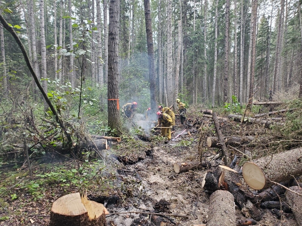
Crews working to extinguish hotspots, August 15, 2023.
THE LONG LAKE FIRE | AUGUST 16, 2023 AS OF 2:00 PM
An Incident Management Team (IMT) is managing fires HWF036 and HBZ003.
HWF036 | This wildfire is classified as being held (BH) at 186,528 hectares. Being held means that given current weather conditions and resources, the wildfire is not anticipated to grow past expected boundaries.
Firefighters and heavy equipment continue to strengthen and extend the containment lines in key areas to prevent the spread of the wildfire. Helicopters and crews continue to work to protect critical infrastructure on the west side. The northeast guard protecting the community of Chateh continues to hold.
Moderate fire behaviour was observed yesterday due to cloud cover with the west flank being the most active. Firefighters are still seeing flaring trees on the western edges. The forest fuels, like needles and branches, are still dry and significant rain will be required to change these conditions. Higher temperatures later into the week will increase fire behaviour which will become challenging for firefighters working along the west flank.
Firefighters were building helicopter pads by clearing trees to allow easier access to the fireline. Crews also continue to search for and extinguish hotspots along the south edge of the wildfire but will be moved according to the wildfire conditions.
We are asking the public, residents and industry to use extra caution around areas impacted by wildfire and to not walk near or into burnt areas. There are many hazards that are difficult to see, like deep burning ash pits, unstable trees that can fall because their roots have been burnt away, as well as other unknown dangers. Fallen trees on various roads have been reported. If travelling along these burnt areas, be aware and prepared in case these trees fall onto the road, as your vehicle could become entrapped.
HBZ003 | This fire continues to be active on the east and northeast sides. Helicopters have been working the northeast side to slow the spread towards critical infrastructure in the area.
Resources
There are 53 firefighters and support staff working on this wildfire from the United States and Alberta. Eight helicopters and heavy equipment are also supporting these operations. Additional helicopters and airtankers are available if required.
Weather
Today the forecasted temperature is 24 degrees, a relative humidity of 30 percent with winds out of the west at 15-20 km/h gusting to 35 km/h.
WILDFIRE INFORMATION
Download the Alberta Wildfire app today and get access to accurate, real-time information on wildfires in your area. You can also find information on fire advisories, restrictions and bans across the province and much more all on your mobile device. Available for Apple and Android.
Before heading out, please check albertafirebans.ca to determine whether there are any fire advisories, fire restrictions or fire bans in effect for your destination.
Subscribe to the High Level Forest Area Update to receive an email when new information is posted. Join the conversation on Facebook, Twitter or Instagram.
WILDFIRE LINKS AND TOOLS
Volunteers, equipment owners/operators or firefighters looking to assist with these wildfires or any of the wildfires within the province can contact EmergencySupportOffers@gov.ab.ca.
There are multiple EVACUATION ORDERS & ALERTS in the Province. Please visit Alberta Emergency Alerts or your community webpage for more information.
To see all the wildfires burning in Alberta click here.
WILDFIRE PREPAREDNESS | Learn how you can prepare yourself for a wildfire by clicking here.
Acting Information Officer - High Level Forest Area