

The fire danger in the Fort McMurray Forest Area is overall VERY HIGH, with the exception of the area north of Lake Athabasca where the fire danger is EXTREME.
Please use caution if you are spending time in forested areas. If you see smoke or fire in the forest call 310-FIRE (3473).
A fire advisory is in effect for the portion of the Fort McMurray Forest Area located north of Lake Athabasca and east of Wood Buffalo National Park.
Under this advisory:
All existing fire permits are suspended and no new permits will be issued.
Prohibited:
Any burning without a valid fire permit, other than a campfire, is prohibited.
Allowed:
Safe wood campfires *
Backyard fire pits
Portable propane fire pits
Gas or propane stoves and barbecues
Catalytic or infrared-style heaters
*Safe wood campfires should be within a metal, brick, or rock fire ring. They are required to:
a) be on rock, gravel, sand, or another non-combustible surface that extends at least one metre around the fire;
b) have a responsible person in attendance to keep fire under control at all times and extinguish before leaving;
c) have on hand enough water on site to extinguish the fire.
Safe wood campfires on private lands include private land campgrounds and private land recreation areas. Municipalities, parks and protected areas may have additional fire safety requirements.
Never leave a campfire unattended. Soak it, stir it and soak it again until cool to the touch to ensure it is extinguished. If you see a wildfire, report it immediately by calling 310-FIRE.
The fire advisory will remain in effect until conditions improve.
.jpg?width=1700&name=Fire_Advisory_2022_zoomed_8x11%20(002).jpg)
FORT MCMURRAY WILDFIRE UPDATE
Since January 1, 2022, there have been 32 wildfires in the Fort McMurray Forest Area burning a total of 11,384 ha.
MWF015 was detected on June 12 and is located 24 km southeast of Fort Fitzgerald, 49 km southeast of Fort Smith and 115 km north of Fort Chipewyan. It is currently estimated to be 1,399 ha in size and classified as being held.
MWF018 was detected on June 13 and is located 28 km south southeast of Fort Fitzgerald, 50 km southeast of Fort Smith and 90 km north of Fort Chipewyan. It is currently estimated to be 2,810 ha in size and classified as being held.
MWF022 was detected on June 13 and is located 65 km southeast of Fort Fitzgerald and 62 km north northeast of Fort Chipewyan. It is currently estimated to be 7,092 ha in size and classified as being held.
MWF031 was detected on June 25 and is located 32 km north of Fort Chipewyan. It is currently estimated to be 33 ha in size and is classified as being held.
Since these wildfires are located in remote areas where they do not threaten communities or resources, we allow the wildfires to play out their natural role onto the landscape under the watchful eye of experienced fire managers. Using this wildfire management strategy has many benefits. It re-introduces fire onto the landscape, creates a break in the continuous fuels, reduces the intensity of the fire, provides safety zones for our firefighting crews to work from and reduces the cost of fighting these wildfires.
All of the above mentioned wildfires were caused by lightning. To learn more about the classification of wildfires, please click here.
To view the wildfires on a map, check out the new wildfire dashboard. It provides up-to-date wildfire information at the click of a button. This interactive tool displays important statistics on the number of active wildfires in the province, sizes, locations, suspected causes and more.
.jpg?width=1604&name=MWF031_JenningsS_20220628%20(3).jpg) Wildfire MWF031 was located on June 25, 2022.
Wildfire MWF031 was located on June 25, 2022.
PROVINCIAL WILDFIRE UPDATE
Since January 1, 2022 in the Forest Protection Area, there have been 490 wildfires burning a total of 24,245.93 ha.
FIRESMART
Using FireSmart principles is becoming a way of life for many communities in North America. With so many neighborhoods threatened by wildfire each year, residents are taking action and reducing the risk to their homes, cabins and properties.
Being FireSmart doesn't have to be complicated and there are many resources to help you get started. You can check out some easy tasks by visiting firesmartcanada.ca, click here to watch a video or you can take the FireSmart Canada FREE one-hour course by clicking here.
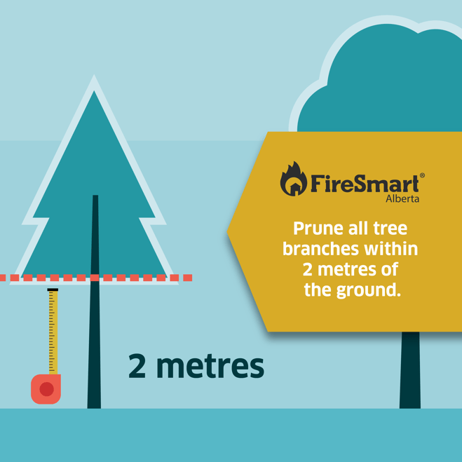
Pruning the tree branches near your home and on your property can prevent a possible ground fire from turning into a crown fire.
OHV SAFETY
Use caution when riding your off-highway vehicle in forested areas.
-
Exhaust systems heat up to temperatures in excess of 204 degrees Celsius; hot enough to fry an egg and start a wildfire.
-
At these temperatures, built up materials and debris on your machine (such as grass, muskeg, moss, or other debris) can heat up, smoulder and ignite.
-
The shouldering debris can drop to the ground as you’re riding, starting a wildfire.
Before you ride, clean any debris that has built up near the exhaust and muffler, under the seat, in wheel wells and around the engine. During your ride, stop regularly to clean your hotspots. Dry grass and vegetation that accumulate near the exhaust, ignite and cause a wildfire when it falls to the ground. Always carry a small fire extinguisher, a collapsible shovel and water. These tools can help extinguish a wildfire and safely dispose of hot debris.
REQUEST A FIRE PERMIT
Wildfire season in Alberta is from March 1 until October 31. During wildfire season, you are required to have a fire permit if you plan on burning in the Forest Protection Area, with the exception of a campfire.
To request a free fire permit online, visit the new portal. You will need a MyAlberta Digital ID to access the portal. Please note that you can still request your permit from the Fort McMurray forest office by calling 780-743-7125.
For more information regarding fire permits, you can view our video by clicking here.
NEW WILDFIRE DASHBOARD
The new wildfire dashboard provides up-to-date wildfire information at the click of a button. This interactive tool displays important statistics on the number of active wildfires in the Forest Protection Area of Alberta, sizes, locations, suspected causes and more.
The dashboard builds on the former wildfire status map by displaying the most frequently accessed information in one convenient location.
.png?width=654&name=WF_Social-images%20(7).png)
For more information, please contact:
RELATED INFORMATION
Websites:
- Alberta Wildfire
- Alberta Fire Bans
- FireSmart in Alberta
- Alberta Emergency Alerts
- Air Quality Health Index
- Wildfire Smoke and Your Health
- 511 Road Reports
- Emergency Preparation
Social Media: