

WILDFIRE DANGER
The wildfire danger is VERY HIGH south of Lake Athabasca and EXTREME north of Lake Athabasca, within the Fort McMurray Forest Area.
A fire advisory remains in effect for the Fort McMurray Forest Area. See details below.
Please be very cautious when spending time outdoors, as conditions are dry and windy. Wildfires can ignite easily and spread quickly.
Report wildfires immediately by calling 310-FIRE (3473).
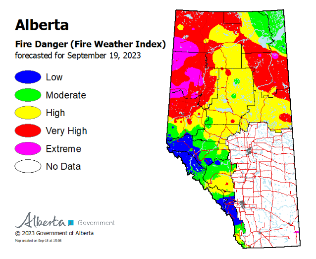
The forecasted fire danger map is updated daily around 3 pm.
SMOKY CONDITIONS
Due to the numerous wildfires in western Canada, smoky conditions will continue. Anyone with health concerns should visit Alberta Health Services or call 811 for health advice from Alberta Health Link. Before travelling check 511 Alberta for information the latest road conditions or closures. Visit Fire Smoke Canada to see where the smoke is coming from. To view wildfires on a map, download the AB Wildfire Status App or visit the Alberta Wildfire Status Dashboard.
WILDFIRE OF NOTE
Wood Buffalo Complex
(Previously Parks Canada Fire 7, Alberta Wildfire MNZ003, and NWT SS069)
Click here to view the most recent map.
Managed under unified command between Alberta Wildfire, the Government of the Northwest Territories, and Parks Canada from the incident command post in Fort Smith.
The Unified Command Team would like to welcome the residents of Fort Smith back to their community. Over the past five weeks, several hundred people have worked towards this goal and we look forward to seeing you in the community again.
Members of the Unified Command Team will be available to answer any of your questions about the incident at the Town of Fort Smith's Welcome Centre located in the recreation and community centre.
.jpg?width=519&height=703&name=A%20firefighter%20puts%20out%20a%20tree%20candling%20fire%20(Sept.%2017%202023).jpg)
A firefighter puts out a tree candling fire (Sept. 17 2023).
The Wood Buffalo Complex was last estimated at 488,300 hectares in size.
The northern perimeter of the fire closest to communities where fire growth has been deemed intolerable is mapped at 146 kilometres in length. 78km of this fire perimeter is now considered controlled, and 39km is considered contained. A controlled fire perimeter is the portion of fire perimeter that has received sufficient suppression action to ensure no further spread of fire. A contained fire perimeter is the portion of the fire perimeter that is not expected to spread given current resource commitments and forecasted weather and fire behavior conditions.
Together, 92 percent of the northern perimeter is now considered contained or controlled.
There are currently 269 personnel responding to the Wood Buffalo Complex, which includes 30 pieces of heavy equipment, 14 helicopters and 139 firefighters and structure protection firefighters. These numbers fluctuate as personnel leave the incident for much needed rest and new personnel and resources arrive.
Conditions:
Warm, dry and windy conditions are forecast to continue today, bringing with them potential for increased fire activity.
Today’s high is forecast to be 22 degrees Celsius and a relative humidity of 25-30 percent. Southwesterly winds are forecast at 15 km/h, gusting to 25-30 km/h. There is a chance of isolated showers this afternoon into the evening however only very minimal precipitation is anticipated.
A modest cooling trend is in the forecast for mid-week, however the warmer temperatures are expected to return by Thursday and continue into the weekend. Daily highs remain approximately 7 degrees Celsius higher than the seasonal average.
What is being done:
Yesterday a member of the public entered the closed area along Foxholes Road while ignition operations were taking place. Unauthorized access to areas where active firefighting operations are occurring can put your life at risk. We know that many people are curious about the status of the fire but it is imperative to respect the closures that are in place for your safety and the safety of firefighters.
.jpg?width=939&height=693&name=A%20crew%20from%20Alberta%20works%20to%20extenguish%20hot%20spots%20%20(Sept.%2017%202023).jpg)
A crew from Alberta works to extenguish hot spots (Sept. 17 2023).
Thebacha: Crews conducted a small-scale ignition to help tie the northern perimeter of the fire into the Slave River. This will shore up control lines in the area and help prevent the fire from spreading west along the river Crews continue to extinguish hotspots along Connie’s Road and Foxholes Road. Structure protection remains in place along the Thebacha Road. Closures for all three roads are being implemented and we ask that you please give our crews the space they need to work safely.
Fort Fitzgerald: Firefighters worked to suppress active fire south of Fort Fitzgerald. Poor flying conditions meant that work was limited to areas accessible by ground. Crews and heavy equipment are working east from the Hay Camp Road along the dozer guard to extinguish hotspots in this area. The fire has burned deeply into the ground here and this work is anticipated to take some time.
Heat-sensing scans continue to be completed on a regular basis to help firefighters find and extinguish hot spots.
Fort Smith: The evacuation order for the Town of Fort Smith has been lifted, effective at 8:00 AM this morning. An Evacuation alert remains in place. For updates on the Town's re-entry plan, visit https://fortsmith.ca/re-entry-updates
Hwy 5: Highway 5 has opened to the public as of 6 a.m. this morning to align with the Town of Fort Smith’s re-entry plan. Crews continue to work on demobilizing equipment. A speed reduction to 50 km/h is in place where firefighters are present in order ensure their safety. Please be mindful of crews who continue to work along the road – slow down and give them space to work as you pass.
Reclamation: Crews have begun working to rehabilitate dozer guards that are no longer needed to protect homes and the community. Yesterday, a 5km-stretch along the Parson’s Lake Road was completed and work will continue along the remaining 20 kilometres of the guard.
.jpg?width=531&height=705&name=A%20firefighter%20from%20Quebec%20conducting%20small-ignition%20operations%20(Sept.%2017%202023).jpg)
A firefighter from Quebec conducting small-ignition operations (Sept. 17 2023)
Closures
- Pine Lake Road from Bordertown to Peace Point has reopened with a speed reduction due to potential for unmarked hazards, possible debris on the road and crews working. The road may close without notice due to smoke or fire conditions anyone travelling the road should be prepared for delays.
- Pine Lake Day Use Area remains closed
- Connie’s Road, Foxholes Road and Thebacha Road remain closed due to active wildfire operations.
- Hay Camp Road remains closed
Additional wildfire information
All other wildfires in Wood Buffalo National Park are being actively monitored and do not pose a risk to public safety at this time. Parks Canada will continue to monitor and action these wildfires as required.
For more information on wildfires, visit:
- Wood Buffalo National Park wildfire updates: https://parks.canada.ca/wbnp-fire
- Northwest Territories fire information: https://www.gov.nt.ca/ecc/en/services/wildfire-update
- Alberta Wildfire Status: https://www.alberta.ca/wildfire-status
- For up-to-date road conditions, visit the NWT Highway Conditions website: https://www.dot.gov.nt.ca/Highways
- Follow Fort Smith Protective Services on Facebook at: https://www.facebook.com/FortSmithProtectiveServices
Report any wildfires or suspicious smoke in Alberta to 310-FIRE, in Northwest Territories to 1-877-NWTFIRE, and in Wood Buffalo National Park to 867-621-0136.

FIRE ADVISORY IN EFFECT
A fire advisory is in effect for the entire Fort McMurray Forest Area due to continued hot and dry conditions which will increase the fire behaviour potential.
Under this advisory:
- Existing fire permits are still valid but may be suspended or cancelled if warm, dry weather continues
- The issuing or suspension of new permits is left to the discretion of a forest officer until conditions change
- Permits for the use of fireworks and exploding targets will not be issued.
Prohibited
Any burning without a valid fire permit, other than a campfire.
Allowed
- Safe wood campfires (including charcoal briquettes) in backcountry or random camping areas
- Safe wood campfires (including charcoal briquettes) on private lands and in provincial campgrounds
- Backyard fire pits
- Charcoal briquette barbeques
- Gas and liquid powered appliances (stoves and lanterns)
- Open flame oil devices (e.g., turkey deep fryers, tiki torches)
- Catalytic or infrared-style heaters
- Indoor wood fires
Remember to check the hot spots on your Off-Highway Vehicle (OHV) and remove debris before and after use.
Never leave a campfire unattended. Soak it, stir it and soak it again until cool to the touch to ensure it is extinguished.
If you see a wildfire, report it immediately by calling 310-FIRE.
The fire advisory will remain in effect until conditions improve.
FORT MCMURRAY WILDFIRE UPDATE
Since January 1, 2023 there have been 59 wildfires in the Fort McMurray Forest Area, burning a total of approximately 364,359 hectares (ha).
MWF021 was detected on May 27 and is located approximately 38 km south of Wood Buffalo National Park. This wildfire is classified as under control (UC) and is 14,760 ha in size. This wildfire was caused by lightning.
MWF023 was detected May 28 and is located near Birch Mountains Wildland Provincial Park. This wildfire is classified as under control (UC) and is 54,639 ha in size. This wildfire was caused by lightning.
MWF024 was detected May 28 and is located east of Marguerite River Wildland Provincial Park. This wildfire is classified as under control (UC) and is approximately 28,454 ha in size. This wildfire was caused by lightning.
MWF025 was detected May 28 and is located approximately 7 km north of Fort Chipewyan. This wildfire is classified as being held and is approximately 105,251 ha in size. This wildfire was caused by lightning.
This wildfire no longer poses a threat to the community of Fort Chipewyan, Allison Bay, Dog Head, or the Fort Chipewyan airport. Eighty per cent of the wildfire perimeter is controlled, which includes the entire south perimeter.
MWF038 was detected on June 29 and is located approximately 6 km north of the Slave Lake/Fort McMurray Forest Area border. This wildfire is classified as under control (UC) and is approximately 569 ha in size. This wildfire was caused by lightning.
MWF039 was detected on June 29 and is located within Birch Mountains Wildland Provincial Park but has crossed over into the Slave Lake Forest Area. This wildfire is classified as under control (UC) and is approximately 15,200 ha in size. This wildfire was caused by lightning.
MWF043 was detected on June 30 and is approximately 20 km southeast of Fort Fitzgerald. This wildfire is classified as being held and is approximately 130,805 ha in size. This wildfire was caused by lightning.
This wildfire is not currently moving any closer to Fort Smith or Fort Fitzgerald.
Mutual-aid wildfires:
MNZ001 is located on the south edge of the Alberta/Wood Buffalo National Park border. This wildfire is classified as being held and is approximately 2,595 ha.
PROVINCIAL WILDFIRE UPDATE
ON ALERT
Fire lookouts are on high alert constantly watching for smoke and firefighters in helicopters are assessing potential wildfire sightings, ready to respond to any new wildfires that may start.
Wildland firefighters urge everyone to be extremely cautious when out in the Forest Protection Area. Check your winter burns, and comply with fire bans and OHV restrictions.
.png?width=658&height=345&name=WF_Social-images%20(8).png)
CAMPFIRE SAFETY
Remember to check Alberta Fire Bans for fire advisories, bans or restrictions in your area or destination. If you are camping in a provincial or national park, check the rules and guidelines and be sure to follow them for your safety and the safety of other campers.
Safe wood campfires - should be within a metal, brick, or rock fire ring.
They are required to:
- be on rock, gravel, sand, or another non-combustible surface that extends at least one metre around the fire
- have a responsible person in attendance to keep fire under control at all times and extinguish before leaving
- have enough water on hand to extinguish the fire. Safe wood campfires on private lands include private land campgrounds and private land recreation areas.
Always let the fire burn down before you plan to extinguish it. Spread the embers within the fire pit, then add water or loose dirt and stir. Repeat until your campfire is cool to the touch. You should not be able to feel any heat from the ashes.
OHV SAFETY
If you plan on riding OHVs in the Forest Protection Area of Alberta, you can reduce the risk of your vehicle causing a wildfire by following these simple steps:
- Before you ride, clean out hot spots and remove debris from your machine.
- After riding through muskeg or tall grass, stop and remove any build-up from your machine.
- Carry firefighting equipment such as a small shovel, collapsible pail or fire extinguisher.
- Wash your OHV and keep it clean; do not wash in streams and creeks.
- Make sure your muffler and spark arrestor are working properly.
- Stop frequently. Take the time to knock debris from your machine’s hot spots. If the debris is smouldering, soak it, stir it, and soak it again to make sure it is extinguished.
For more information, see Off-highway vehicles: Wildfire prevention tips.
EXPLODING TARGETS AND FIREWORKS
The Forest and Prairie Protection Act and associated regulations applies to the shooting, ignition or detonation of exploding targets and fireworks on public lands and private lands located within the FPA.
A Forest Officer from the local forest area office may grant written permission to shoot, ignite or detonate exploding targets or fireworks in the FPA. Written permission of exploding targets and fireworks is based on current wildfire danger and managed on a case-by-case basis.
A fire advisory, restriction, ban or forest closure may prohibit or limit use of exploding targets and fireworks during high wildfire hazard situations within the FPA. Check Alberta Fire Bans or download the Alberta Fire Bans app for the latest information.
WILDFIRE DASHBOARD
The wildfire dashboard provides up-to-date wildfire information at the click of a button. This interactive tool displays important statistics on the number of active wildfires in the Forest Protection Area of Alberta, sizes, locations, suspected causes and more.
CONTACT
Websites:
- Alberta Wildfire
- Alberta Fire Bans
- FireSmart in Alberta
- Alberta Emergency Alerts
- Air Quality Health Index
- Wildfire Smoke and Your Health
- 511 Road Reports
- Emergency Preparation
Social media:
Join the conversation on
![]()
![]()
![]()
Apps:
Alberta Wildfire App for Apple or Android and Alberta Fire Bans App for Apple or Android.