

WILDFIRE DANGER
The wildfire danger is HIGH north of Lake Athabasca and LOW south of Lake Athabasca within the Fort McMurray Forest Area. The fire danger in Fort Smith is VERY HIGH.
A fire advisory remains in effect for the Fort McMurray Forest Area. See details below.
Please be very cautious when spending time outdoors, as conditions are dry and windy. Wildfires can ignite easily and spread quickly.
Report wildfires immediately by calling 310-FIRE (3473).
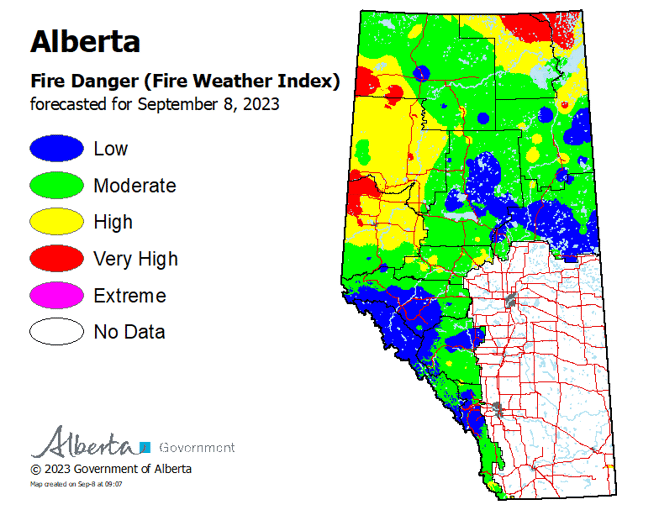
To see the forecasted fire danger click here, updates daily at 3:00 PM.
EVACUATION ORDERS
Highway 5 is currently closed due to wildfire activity. Click here for more highway closure information.
The Regional Municipality of Wood Buffalo (RMWB) has declared a state of local emergency and issued an evacuation order for the community of Fort Fitzgerald. Click here for more information.
The Chief and Council of Smith's Landing First Nation has declared a state of local emergency and issued an evacuation order. Click here for more information.
The Town of Fort Smith has declared a state of local emergency and issued an evacuation order for residents within the municipality and surrounding areas. Click here for more information.
For information on Northwest Territories evacuations click here.
For more information and related links, please see MNZ003 below.
SMOKY CONDITIONS
Due to the numerous wildfires in western Canada, smoky conditions will continue. Anyone with health concerns should visit Alberta Health Services or call 811 for health advice from Alberta Health Link. Before travelling check 511 Alberta for information the latest road conditions or closures. Visit Fire Smoke Canada to see where the smoke is coming from and to view wildfires on a map, download the AB Wildfire Status App or visit the Alberta Wildfire Status Dashboard.
WILDFIRE OF NOTE
Wood Buffalo Complex Wildfire Information Update – September 8, 2023
(Previously Parks Canada Fire 7, Alberta Wildfire MNZ003, and NWT SS069)
To see a map of this wildfire, click here.
Managed under unified command between Alberta Wildfire, the Government of the Northwest Territories, and Parks Canada from the incident command post in Fort Smith.
The Wood Buffalo Complex was last estimated at 473,723* hectares in size and is classified as OUT OF CONTROL, which means that the fire is still burning and is expected to grow.
* When visibility allows, firefighters use multiple tools to measure distances and size. These tools have various accuracies and are subject to change. For up-to-date estimated distances from the fire to each community, please see attached map.
There are currently 362 personnel responding to the Wood Buffalo Complex, which includes 59 pieces of heavy equipment, 18 helicopters and 186 firefighters and structure protection specialists. These numbers fluctuate as personnel leave the incident for much needed rest and new personnel and resources arrive.
Firefighters use tools to expose deep-burning hot spots that will later be extinguished with water. Wood Buffalo Complex (September 7, 2023).
Conditions:
The Fort Smith area continues to be very dry which contributes to challenging firefighting conditions. Above seasonal average temperatures are forecast to return over the weekend and into next week.
In August, the area around Fort Smith usually receives an average of around 64 mm of precipitation – this year the area received 5 mm in total. That is 7.9% of the average monthly precipitation for August.
Today, the forecast calls for a high of 20C and 35% relative humidity. Winds will be southeast turning easterly in the evening at 10 km/hr, gusting 15-20 km/hr. There is no significant precipitation in the short-term forecast.
What is being done:
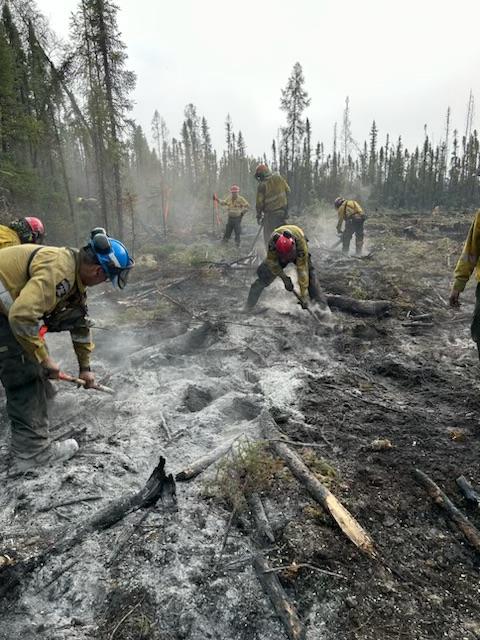
Crews working areas throughout the northeastern perimeter have been reporting 2-3 feet deep hot spots. Putting out spots this deep requires a lot of effort, using different tools, equipment, bucket support from helicopters and lots of water.
Foxholes Road and Thebacha: Firefighters completed work yesterday on spots that crossed the Salt River and continue to do mop-up work along the fire’s edge. No known values in this area have been lost.
Crews continue to work off Foxholes Road in several areas to suppress the fire perimeter and extinguish hot spots. They are also working off a containment line constructed near Grand Detour Road to directly suppress the fire. Yesterday, some ignition was conducted to tie the perimeter of the fire in one place into Foxholes Road. If ideal conditions are met today, a controlled burn may be conducted to tie the perimeter of the fire into on place along Foxholes Road.
Fort Fitzgerald: A 20-pack of firefighters is working along the eastern perimeter lines within and just outside of the Wood Buffalo National Park boundary, extinguishing active hot areas of the fire.
Hwy 5: Firefighters are patrolling the eastern Highway 5 portion of the fire perimeter for any remaining hot spots, but most of the work in this area is done. Good news!
Perimeter line south of Fort Smith: The extra hard work firefighters have been putting into this area is paying off, and remaining hot spots are dwindling. Today, they’ll continue to extinguish the few remaining hot spots here and will begin patrolling and monitoring this line to ensure it is extinguished far enough in.
Heat-sensing scans were completed last night and continue to showcase the great work crews are doing on the ground. The repeated nightly scans help firefighters find and extinguish hot spots. The scans assign each heated area to a GPS coordinate, which crews use to zone in on the spots and take a “seek and destroy” approach, extinguishing them one-by-one.
Helicopters yesterday were unable to fly until the afternoon due to poor visibility. Once skies cleared, they assisted with moving firefighters to more remote areas of the fireline and fire suppression via bucketing, as needed.
Structure protection specialists keep up the work of testing and maintaining high-volume lines and sprinkler systems in communities. Part of their work includes assisting with extinguishing hot spots and securing perimeters around values near the fire.
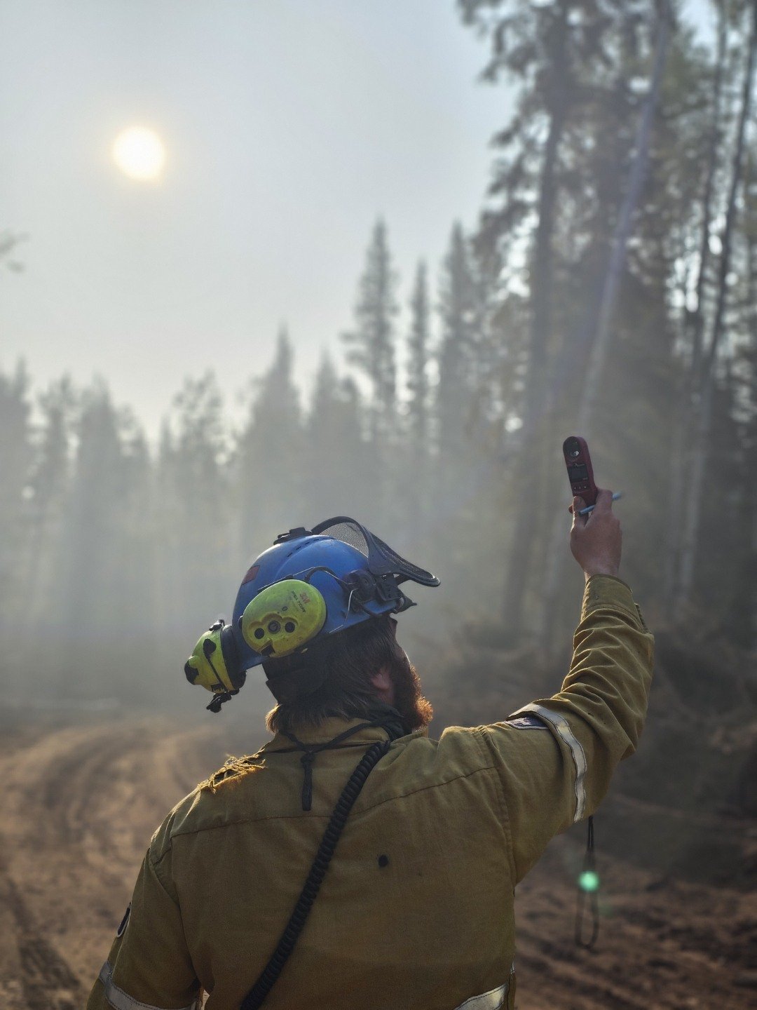 A firefighter takes a weather reading while on the line. The data captured will be reported back to one of the fire behaviour analysts, which will contribute to more accurate weather forecasting and help fire specialists better predict future fire behaviour patterns (September 7, 2023).
Question: What needs to happen before we can come home?
Progress continues and we are getting closer each day. We know you’ve been away from home for a while now, and we’re working with the Town of Fort Smith and doing everything we can to get you back as soon as it is safe to do so.
Before fire personnel can recommend to communities that it’s safe to return, the northeastern perimeter of the fire – stretching from Thebacha down underneath Fort Smith and across to below Fort Fitzgerald – must be free of hot spots and extinguished far enough in that fire will not spread outside the current boundary. Structure protection around communities will also need to be removed.
Communities have been doing re-entry planning, so once the recommendation from fire personnel is made, it will trigger the start of their re-entry plans. For more information on those plans, please reach out to your community.
Until re-entry plans begin, it is still unsafe for members of the public to be here. Large equipment, fire operations and structure protection systems require extra room. There are limited supplies in the community – what remains is needed to ensure first responders are properly equipped to stay here and manage the incident.
Messages from your communities:
The Town of Fort Smith and Fort Fitzgerald are under a STATE OF LOCAL EMERGENCY and remain under an EVACUATION ORDER. The ORDER has been issued for public safety. If you have evacuated, please do not return. If you return, you are directly impeding operations that are working to protect your community.
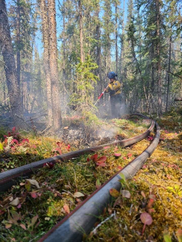
A firefighter works to extinguish a hot spot on an area of the Wood Buffalo Complex fire using water and hose (September 7, 2023).
Closures:
- Highway 5 is currently closed from Hay River to Fort Smith due to safety concerns and limited visibility. Click here for highway closure information.
- Pine Lake Road from Bordertown to Peace Point remains CLOSED due to fire behaviour and active fire operations in the area.
Additional wildfire information
All other wildfires in Wood Buffalo National Park are being actively monitored and do not pose a risk to public safety at this time. Parks Canada will continue to monitor and action these wildfires as required. For more information visit Wood Buffalo National Park wildfire updates.
For information on other wildfires visit the respective webpages:
Wood Buffalo National Park wildfire updates
Northwest Territories fire information
Alberta Wildfire Status Dashboard
Report any wildfires or suspicious smoke in Alberta to 310-FIRE, in Northwest Territories to 1-877-NWTFIRE, and in Wood Buffalo National Park to 867-621-0136.

FIRE ADVISORY IN EFFECT
A fire advisory is in effect for the entire Fort McMurray Forest Area due to continued hot and dry conditions which will increase the fire behaviour potential.
Under this advisory:
- Existing fire permits are still valid but may be suspended or cancelled if warm, dry weather continues
- The issuing or suspension of new permits is left to the discretion of a forest officer until conditions change
- Permits for the use of fireworks and exploding targets will not be issued.
Prohibited
Any burning without a valid fire permit, other than a campfire.
Allowed
- Safe wood campfires (including charcoal briquettes) in backcountry or random camping areas
- Safe wood campfires (including charcoal briquettes) on private lands and in provincial campgrounds
- Backyard fire pits
- Charcoal briquette barbeques
- Gas and liquid powered appliances (stoves and lanterns)
- Open flame oil devices (e.g., turkey deep fryers, tiki torches)
- Catalytic or infrared-style heaters
- Indoor wood fires
Remember to check the hot spots on your Off-Highway Vehicle (OHV) and remove debris before and after use.
Never leave a campfire unattended. Soak it, stir it and soak it again until cool to the touch to ensure it is extinguished.
If you see a wildfire, report it immediately by calling 310-FIRE.
The fire advisory will remain in effect until conditions improve.
FORT MCMURRAY WILDFIRE UPDATE
Since January 1, 2023 there have been 58 wildfires in the Fort McMurray Forest Area, burning a total of approximately 364,359 hectares (ha).
MWF021 was detected on May 27 and is located approximately 38 km south of Wood Buffalo National Park. This wildfire is classified as under control (UC) and is 14,760 ha in size. This wildfire was caused by lightning.
MWF023 was detected May 28 and is located near Birch Mountains Wildland Provincial Park. This wildfire is classified as under control (UC) and is 54,639 ha in size. This wildfire was caused by lightning.
MWF024 was detected May 28 and is located east of Marguerite River Wildland Provincial Park. This wildfire is classified as under control (UC) and is approximately 28,454 ha in size. This wildfire was caused by lightning.
MWF025 was detected May 28 and is located approximately 7 km north of Fort Chipewyan. This wildfire is classified as being held and is approximately 105,251 ha in size. This wildfire was caused by lightning.
This wildfire no longer poses a threat to the community of Fort Chipewyan, Allison Bay, Dog Head, or the Fort Chipewyan airport. Eighty per cent of the entire wildfire perimeter is controlled, which includes the entire south perimeter.
MWF038 was detected on June 29 and is located approximately 6 km north of the Slave Lake/Fort McMurray Forest Area border. This wildfire is classified as under control (UC) and is approximately 569 ha in size. This wildfire was caused by lightning.
MWF039 was detected on June 29 and is located within Birch Mountains Wildland Provincial Park but has crossed over into the Slave Lake Forest Area. This wildfire is classified as under control (UC) and is approximately 15,200 ha in size. This wildfire was caused by lightning.
MWF043 was detected on June 30 and is approximately 20 km southeast of Fort Fitzgerald. This wildfire is classified as being held and is approximately 130,805 ha in size. This wildfire was caused by lightning.
This wildfire is not currently moving any closer to Fort Smith or Fort Fitzgerald.
Mutual-aid wildfires:
MNZ001 is located on the south edge of the Alberta/Wood Buffalo National Park border. This wildfire is classified as being held and is approximately 2,595 ha.
PROVINCIAL WILDFIRE UPDATE
ON ALERT
Fire lookouts are on high alert constantly watching for smoke and firefighters in helicopters are assessing potential sightings of wildfires, ready to respond to any new wildfires that may start.
Wildland firefighters urge everyone to be extremely cautious when out in the Forest Protection Area. Check your winter burns, and comply with fire bans and OHV restrictions.
.png?width=658&height=345&name=WF_Social-images%20(8).png)
CAMPFIRE SAFETY
Remember to check Alberta Fire Bans for fire advisories, bans or restrictions in your area or destination. If you are camping in a provincial or national park, check the rules and guidelines and be sure to follow them for your safety and the safety of other campers.
Safe wood campfires - should be within a metal, brick, or rock fire ring.
They are required to:
- be on rock, gravel, sand, or another non-combustible surface that extends at least one metre around the fire
- have a responsible person in attendance to keep fire under control at all times and extinguish before leaving
- have enough water on hand to extinguish the fire. Safe wood campfires on private lands include private land campgrounds and private land recreation areas.
Always let the fire burn down before you plan to extinguish it. Spread the embers within the fire pit, then add water or loose dirt and stir. Repeat until your campfire is cool to the touch. You should not be able to feel any heat from the ashes.
OHV SAFETY
If you plan on riding OHVs in the Forest Protection Area of Alberta, you can reduce the risk of your vehicle causing a wildfire by following these simple steps:
- Before you ride, clean out hot spots and remove debris from your machine.
- After riding through muskeg or tall grass, stop and remove any build-up from your machine.
- Carry firefighting equipment such as a small shovel, collapsible pail or fire extinguisher.
- Wash your OHV and keep it clean; do not wash in streams and creeks.
- Make sure your muffler and spark arrestor are working properly.
- Stop frequently. Take the time to knock debris from your machine’s hot spots. If the debris is smouldering, soak it, stir it, and soak it again to make sure it is extinguished.
For more information, see Off-highway vehicles: Wildfire prevention tips.
EXPLODING TARGETS AND FIREWORKS
The Forest and Prairie Protection Act and associated regulations applies to the shooting, ignition or detonation of exploding targets and fireworks on public lands and private lands located within the FPA.
A Forest Officer from the local forest area office may grant written permission to shoot, ignite or detonate exploding targets or fireworks in the FPA. Written permission of exploding targets and fireworks is based on current wildfire danger and managed on a case-by-case basis.
A fire advisory, restriction, ban or forest closure may prohibit or limit use of exploding targets and fireworks during high wildfire hazard situations within the FPA. Check Alberta Fire Bans or the mobile phone app for the latest information.
WILDFIRE DASHBOARD
The wildfire dashboard provides up-to-date wildfire information at the click of a button. This interactive tool displays important statistics on the number of active wildfires in the Forest Protection Area of Alberta, sizes, locations, suspected causes and more.
CONTACT
Websites:
- Alberta Wildfire
- Alberta Fire Bans
- FireSmart in Alberta
- Alberta Emergency Alerts
- Air Quality Health Index
- Wildfire Smoke and Your Health
- 511 Road Reports
- Emergency Preparation
Social media:
Join the conversation on
![]()
![]()
![]()
Apps:
Alberta Wildfire App for Apple or Android and Alberta Fire Bans App for Apple or Android.