

WILDFIRE DANGER
The wildfire danger is HIGH within the Fort McMurray Forest Area.
A fire advisory remains in effect for the Fort McMurray Forest Area. See details below.
Please be very cautious when spending time outdoors, as conditions are dry and windy. Wildfires can ignite easily and spread quickly.
Report wildfires immediately by calling 310-FIRE (3473).
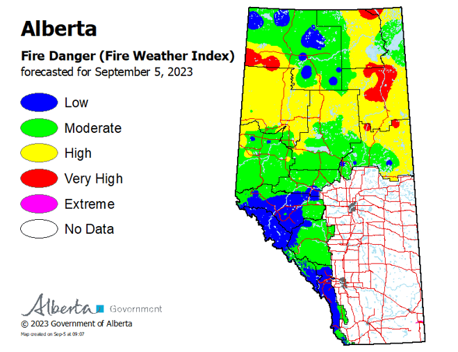
To see the forecasted fire danger click here, updates daily at 3:00 PM.
EVACUATION ORDERS
Highway 5 is currently closed due to wildfire activity. Click here for more highway closure information.
The Regional Municipality of Wood Buffalo (RMWB) has declared a state of local emergency and issued an evacuation order for the community of Fort Fitzgerald. Click here for more information.
The Chief and Council of Smith's Landing First Nation has declared a state of local emergency and issued an evacuation order. Click here for more information.
The Town of Fort Smith has declared a state of local emergency and issued an evacuation order for residents within the municipality and surrounding areas. Click here for more information.
For information on Northwest Territories evacuations click here.
For more information and related links, please see MNZ003 below.
SMOKY CONDITIONS
Due to the numerous wildfires in western Canada, smoky conditions will continue. Anyone with health concerns should visit Alberta Health Services or call 811 for health advice from Alberta Health Link. Before travelling check 511 Alberta for information the latest road conditions or closures. Visit Fire Smoke Canada to see where the smoke is coming from and to view wildfires on a map, download the AB Wildfire Status App or visit the Alberta Wildfire Status Dashboard.
WILDFIRE OF NOTE
Wood Buffalo Complex (previously Parks Canada Fire 7, Alberta Wildfire MNZ003, and NWT SS069)
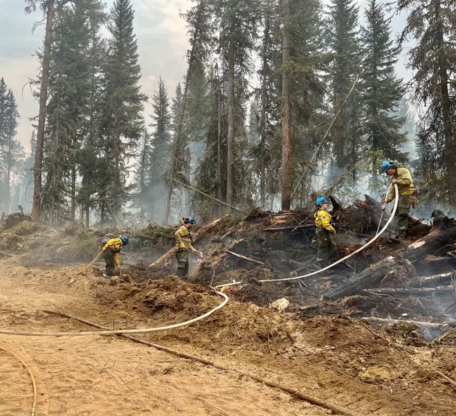 A fire crew works along a containment line to cool the area off and start extinguishing further in (September 4, 2023).
Click here to see the most recent map.
Wood Buffalo Complex (previously Parks Canada Fire 7, Alberta Wildfire MNZ003, and NWT SS069)
Managed under unified command between Alberta Wildfire, the Government of the Northwest Territories, and Parks Canada from the incident command post in Fort Smith.
The Wood Buffalo Complex was last estimated at 476,860* hectares in size and is classified as OUT OF CONTROL, which means that the fire is still burning and is expected to grow. The increase in size is due to more accurate mapping after September 2nd’s large wind event.
*When visibility allows, firefighters use multiple tools to measure distances and size. These tools have various accuracies and are subject to change. For up-to-date estimated distances from the fire to each community, please see attached map.
There are currently 412 personnel, 70 pieces of heavy equipment, 19 helicopters and 202 firefighters and structure protection specialists responding to the Wood Buffalo Complex. These numbers fluctuate as personnel leave the incident for much needed rest and new personnel and resources arrive.
We know you’ve been away from home for awhile now, and we’re doing everything we can to get you back as soon as it is safe to do so. Please do not return to or visit evacuated communities. It is still unsafe for members of the public to be here. Large equipment, fire operations and structure protection systems require extra room and need to focus on fire suppression. There are limited supplies in the community – what remains is needed to ensure first responders are properly equipped to stay here and manage the incident.
Today, a high of 15 C is expected, with a relative humidity of 40 percent. Winds will be from the east at 5-10 km/hr, gusting 15 km/hr. There is no sign of any significant precipitation in the short or long-term forecast.
What happened yesterday, and what we’re expecting today:
Cool temperatures, along with Sunday’s patchy precipitation, led to good firefighting weather yesterday. There have been a few colder days, but lower relative humidity is coming again, which means we will return to a drying trend. The drought code is still over 1,100, which is very very dry. Since records have been kept, this area’s highest recorded drought code was in the 840s before this summer. In August, the area around Fort Smith usually receives an average of around 64 mm of precipitation – this year the area received 5 mm in total. That is 7.9% of the average monthly precipitation for August.
Fires are burning deep this year. Crews and heavy equipment that have been working along the main northeastern flank, just off Highway 5 and working their way east, are finding hot spots and ash pits that are 2-3 feet deep. It takes a lot of intense, precise work to extinguish a hot area of fire burning that deep. The goal on this flank remains – crews are working on each side, with the goal of meeting in the middle and extinguishing all heat at least 50-100ft in along the way.
Technology like low-level, heat-sensing scans are helping fire crews find and action hot spots faster. The scans pinpoint hot spots with GPS coordinates and firefighters are able to zone in and take a “seek and destroy” approach, extinguishing them one-by-one.
An aerial assessment earlier in the week found a few spots off Foxholes Road after Saturday’s wind event and after greater on-the-ground assessing, more spot fires were found in the area. Crews have been working on the spots found earlier and they’ll start to work on the others today. Firefighters will also keep working on areas up the road further to the north, where the fire has met the Salt River. No known values in this area have been lost. There have been a few small spots that jumped the Salt River, but the fire is along the western side of Foxholes Road, held currently at the river.
Values work by both crews and structure protection specialists continues in the Thebacha area. In addition to pre-existing sprinkler systems, cabins and other values nearest the fire edge have been outfitted with a 50-ft wetline (a control line established by wetting down unburned or “green” areas with water), added suppression efforts, and have had danger trees removed.
Heavy equipment connected a new containment line near Grand de tour Road into the Slave River today. Crews will follow this containment line with hose to prepare to directly suppress the fire in this area. An ignition specialist assessed this new line for controlled burning potential today. A controlled burn may be conducted to tie the fire into the containment line, if ideal conditions are met.
Alongside heavy equipment like excavators, crews worked on the containment line to the south of Fort Fitzgerald and along Hay Camp Road. The heavy equipment helps firefighters gain better access to hot spots by pulling apart birms and dirt and make extinguishment easier. In the coming days, a 20-pack of firefighters will start to access and directly attack fire along the perimeter line to the west of Fort Fitzgerald within the Wood Buffalo National Park boundary.
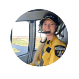
Helicopters continue to support suppression efforts and bucket pockets of higher activity as required, working in close communication with firefighters on the ground.
Structure protection specialists continue to test and maintain high-volume lines and sprinkler systems in communities and across the fire perimeter, as well as support firefighters with extinguishment lines on values near the fire perimeter.
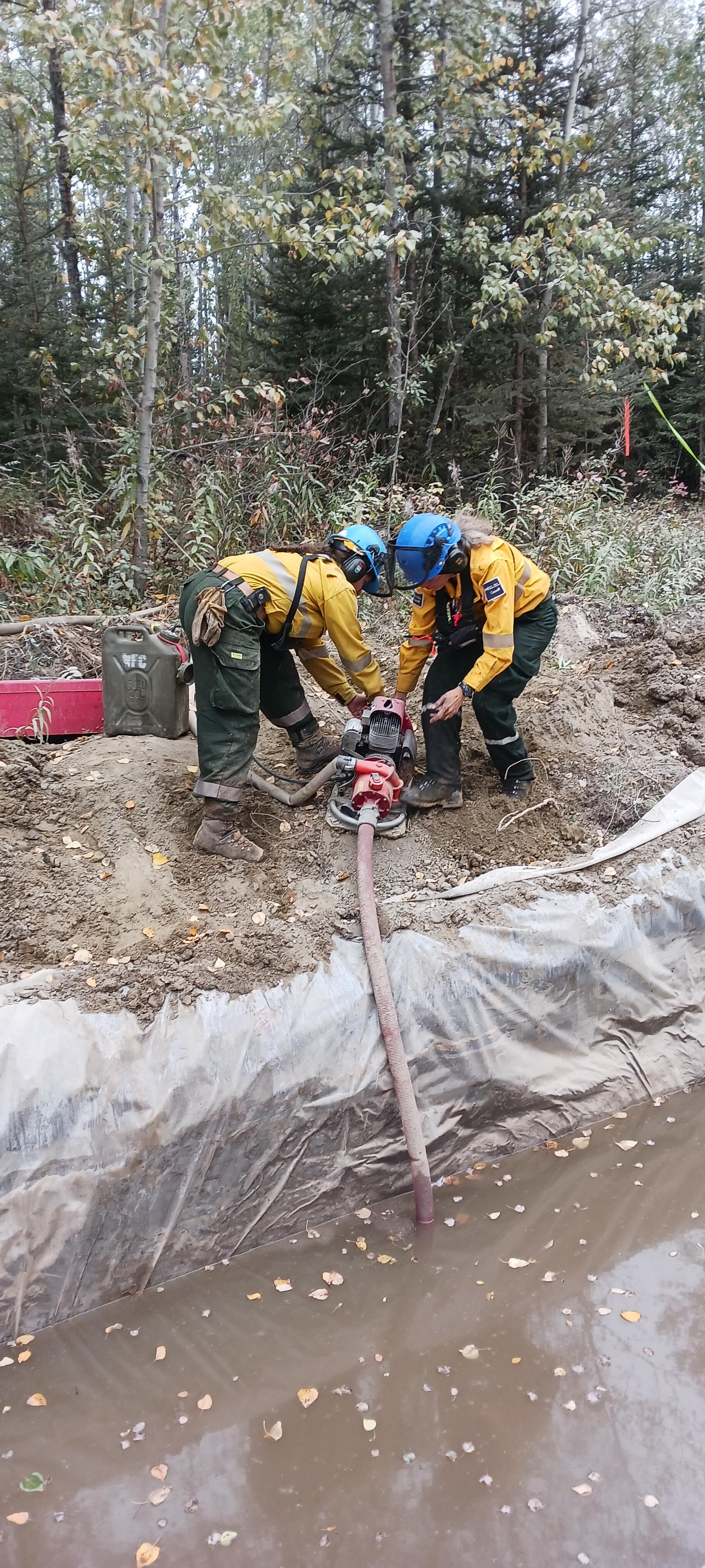 Two firefighters refuel a pump by a bell hole, which is an excavator-dug hole lined with poly and filled by a water tender. Bell holes are used when there is no nearby water source. This pump and hose system is either connected to structure protection systems on values in the area or may be being used for suppression efforts by firefighters working nearby (September 2, 2023).
Frequently Asked Questions (FAQs):
Q: In a previous update, you mentioned wildland-urban interface firefighters. And you talk about structure protection a lot. What does that mean?
Areas where homes and other human-built infrastructure meet or have wildland fire fuels within are referred to as a wildland-urban interface. Essentially, it’s a place where the natural environment (like the boreal forest) meets or intermingles with a town or city.
When there’s a wildfire close to a town or city, wildland-urban interface firefighters/structure protection specialists may need to be brought in to help. If a wildfire spreads into a wildland-urban interface (WUI), ignition and burning of structures may occur. Most crews are trained to fight wildfires and may not be trained or equipped to fight structural fires, which have different hazards and risks.
These structure protection specialists are working closely within the incident and with the Town of Fort Smith to plan and oversee structure protection tactics, set up sprinklers, monitor structures close to fire activity and conduct work like FireSmart, hazard prevention burns and other operations that reduce fire risk. They have helped set up high-volume sprinkler systems around town and have coordinated with the town to create containment lines and guards around communities in the area.
What is structure protection?
A main tactic used in structure protection to limit the impact of an approaching fire on structures includes the use of water through sprinkler systems and other means. Firefighters install and set up sprinklers around the structure using hose and pumps in nearby water sources or water bladders.
The structure protection helps create a wet area and bring up the area’s drought conditions to prevent the wildfire from burning near cabins, residences, and other buildings. The increased moisture levels reduce the chance that embers and burning debris can ignite structures.
When fire activity increases near residences, crews will turn on some of the structure protection as a precautionary measure.
Q: What does it take to control 146 km of fire perimeter?
Containing a wildfire’s perimeter takes a lot of work, especially when there has been little precipitation, drought conditions are severe and there’s 146 km of line to extinguish.
Because of how deep some hot spots burn, extinguishing fire is not as easy as putting water on surface fuels (soil, deadfall, etc) and calling it a day. That’s why there is and will continue to be a lot of focus on putting out hot spots.
Fire can burn deep in the duff layer of soil (underground). “Duff” is a layer of soil between the forest floor and deeper mineral soil made up of decomposing plant materials. Fire can smoulder in this layer of soil in cooler temperatures – sometimes even throughout colder fall and winter months. If not fully extinguished, hot spots can pop up again the following spring or summer if fuel remains and the right conditions are present.
Firefighters are extinguishing fire off the perimeter and off containment lines. They generally start from the line or the fire perimeter, working their way in toward the fire. Once the fire is suppressed, hotspotting begins. This is a very hard and long process where firefighters search for hotspots that’s either provided by a heat scan, or they can also use their senses (sight and smell) to find smoke or fire burning deep in the soil. Once found, they will dig out the hotspot, extinguishing by using hand tools, water pumps and hose or at times, helicopters will assist the firefighters with water buckets.
This is just some of the hard work that firefighters have been doing on the northern perimeter of the fire, closest to the communities.
Q: Who is here helping? Is there anyone from other countries or far off places?
There are a lot of folks here helping. They’re working as heavy equipment operators, fire crew members, incident management team members and many Fort Smith Fire/EMS volunteers stayed behind to help secure the town and install and maintain structure protection systems.
Fire specialists from as far away as New Zealand are working on the Wood Buffalo Complex. We’ve also welcomed support from our neighbours to the South and have fire personnel from Idaho, United States helping us out as well as folks from Nova Scotia, New Brunswick, Ontario, and Quebec.
They join fire personnel from the Northwest Territories, Alberta and Parks Canada (who span many provinces). Many structure protection specialists/ wildland-urban interface firefighters are also here as units from municipalities across Alberta.
Do you have any messages of encouragement for them? If you do, we’ll gladly collect the messages and make sure they feel your appreciation and support. You can send to wbnpfire-feupnwb@pc.gc.ca or message them to us on Facebook.
Message from your communities
The Town of Fort Smith and Fort Fitzgerald are under a STATE OF LOCAL EMERGENCY and remain under an EVACUATION ORDER. The ORDER has been issued for public safety. If you have evacuated, please do not return. This is an active wildfire operation area and is dangerous for residents and first responders. You can visit the Town of Fort Smith webpage for additional information.
Closures:
- Highway 5 is currently closed from Hay River to Fort Smith due to safety concerns and limited visibility. Click here for highway closure information.
- Pine Lake Road from Bordertown to Peace Point remains CLOSED due to fire behaviour and active fire operations in the area.
Additional wildfire information
All other wildfires in Wood Buffalo National Park are being actively monitored and do not pose a risk to public safety at this time. Parks Canada will continue to monitor and action these wildfires as required. For more information visit Wood Buffalo National Park wildfire updates.
For information on other wildfires visit the respective webpages:
Wood Buffalo National Park wildfire updates
Northwest Territories fire information
Alberta Wildfire Status Dashboard
Report any wildfires or suspicious smoke in Alberta to 310-FIRE, in Northwest Territories to 1-877-NWTFIRE, and in Wood Buffalo National Park to 867-621-0136.
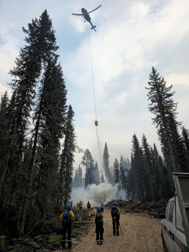
A helicopter supports fire operations by working with crews on-the-ground and bucketing water to cool down a more active area along a containment line. (September 3, 2023).

FIRE ADVISORY IN EFFECT
A fire advisory is in effect for the entire Fort McMurray Forest Area due to continued hot and dry conditions which will increase the fire behaviour potential.
Under this advisory:
- Existing fire permits are still valid but may be suspended or cancelled if warm, dry weather continues
- The issuing or suspension of new permits is left to the discretion of a forest officer until conditions change
- Permits for the use of fireworks and exploding targets will not be issued.
Prohibited
Any burning without a valid fire permit, other than a campfire.
Allowed
- Safe wood campfires (including charcoal briquettes) in backcountry or random camping areas
- Safe wood campfires (including charcoal briquettes) on private lands and in provincial campgrounds
- Backyard fire pits
- Charcoal briquette barbeques
- Gas and liquid powered appliances (stoves and lanterns)
- Open flame oil devices (e.g., turkey deep fryers, tiki torches)
- Catalytic or infrared-style heaters
- Indoor wood fires
Remember to check the hot spots on your Off-Highway Vehicle (OHV) and remove debris before and after use.
Never leave a campfire unattended. Soak it, stir it and soak it again until cool to the touch to ensure it is extinguished.
If you see a wildfire, report it immediately by calling 310-FIRE.
The fire advisory will remain in effect until conditions improve.
FORT MCMURRAY WILDFIRE UPDATE
Since January 1, 2023 there have been 58 wildfires in the Fort McMurray Forest Area, burning a total of approximately 359,554 hectares (ha).
MWF021 was detected on May 27 and is located approximately 38 km south of Wood Buffalo National Park. This wildfire is classified as under control (UC) and is 14,760 ha in size. This wildfire was caused by lightning.
MWF023 was detected May 28 and is located near Birch Mountains Wildland Provincial Park. This wildfire is classified as under control (UC) and is 54,639 ha in size. This wildfire was caused by lightning.
MWF024 was detected May 28 and is located east of Marguerite River Wildland Provincial Park. This wildfire is classified as under control (UC) and is approximately 28,454 ha in size. This wildfire was caused by lightning.
MWF025 was detected May 28 and is located approximately 7 km north of Fort Chipewyan. This wildfire is classified as being held and is approximately 105,251 ha in size. This wildfire was caused by lightning.
This wildfire no longer poses a threat to the community of Fort Chipewyan, Allison Bay, Dog Head, or the Fort Chipewyan airport. Eighty per cent of the entire wildfire perimeter is controlled, which includes the entire south perimeter.
MWF038 was detected on June 29 and is located approximately 6 km north of the Slave Lake/Fort McMurray Forest Area border. This wildfire is classified as under control (UC) and is approximately 569 ha in size. This wildfire was caused by lightning.
MWF039 was detected on June 29 and is located within Birch Mountains Wildland Provincial Park but has crossed over into the Slave Lake Forest Area. This wildfire is classified as under control (UC) and is approximately 15,200 ha in size. This wildfire was caused by lightning.
MWF043 was detected on June 30 and is approximately 20 km southeast of Fort Fitzgerald. This wildfire is classified as being held and is approximately 130,805 ha in size. This wildfire was caused by lightning.
This wildfire is not currently moving any closer to Fort Smith or Fort Fitzgerald.
Mutual-aid wildfires:
MNZ001 is located on the south edge of the Alberta/Wood Buffalo National Park border. This wildfire is classified as being held and is approximately 2,595 ha.
PROVINCIAL WILDFIRE UPDATE
ON ALERT
Fire lookouts are on high alert constantly watching for smoke and firefighters in helicopters are assessing potential sightings of wildfires, ready to respond to any new wildfires that may start.
Wildland firefighters urge everyone to be extremely cautious when out in the Forest Protection Area. Check your winter burns, and comply with fire bans and OHV restrictions.
.png?width=658&height=345&name=WF_Social-images%20(3).png)
CAMPFIRE SAFETY
Remember to check Alberta Fire Bans for fire advisories, bans or restrictions in your area or destination. If you are camping in a provincial or national park, check the rules and guidelines and be sure to follow them for your safety and the safety of other campers.
Safe wood campfires - should be within a metal, brick, or rock fire ring.
They are required to:
- be on rock, gravel, sand, or another non-combustible surface that extends at least one metre around the fire
- have a responsible person in attendance to keep fire under control at all times and extinguish before leaving
- have enough water on hand to extinguish the fire. Safe wood campfires on private lands include private land campgrounds and private land recreation areas.
Always let the fire burn down before you plan to extinguish it. Spread the embers within the fire pit, then add water or loose dirt and stir. Repeat until your campfire is cool to the touch. You should not be able to feel any heat from the ashes.
OHV SAFETY
If you plan on riding OHVs in the Forest Protection Area of Alberta, you can reduce the risk of your vehicle causing a wildfire by following these simple steps:
- Before you ride, clean out hot spots and remove debris from your machine.
- After riding through muskeg or tall grass, stop and remove any build-up from your machine.
- Carry firefighting equipment such as a small shovel, collapsible pail or fire extinguisher.
- Wash your OHV and keep it clean; do not wash in streams and creeks.
- Make sure your muffler and spark arrestor are working properly.
- Stop frequently. Take the time to knock debris from your machine’s hot spots. If the debris is smouldering, soak it, stir it, and soak it again to make sure it is extinguished.
For more information, see Off-highway vehicles: Wildfire prevention tips.
EXPLODING TARGETS AND FIREWORKS
The Forest and Prairie Protection Act and associated regulations applies to the shooting, ignition or detonation of exploding targets and fireworks on public lands and private lands located within the FPA.
A Forest Officer from the local forest area office may grant written permission to shoot, ignite or detonate exploding targets or fireworks in the FPA. Written permission of exploding targets and fireworks is based on current wildfire danger and managed on a case-by-case basis.
A fire advisory, restriction, ban or forest closure may prohibit or limit use of exploding targets and fireworks during high wildfire hazard situations within the FPA. Check Alberta Fire Bans or the mobile phone app for the latest information.
WILDFIRE DASHBOARD
The wildfire dashboard provides up-to-date wildfire information at the click of a button. This interactive tool displays important statistics on the number of active wildfires in the Forest Protection Area of Alberta, sizes, locations, suspected causes and more.
CONTACT
Websites:
- Alberta Wildfire
- Alberta Fire Bans
- FireSmart in Alberta
- Alberta Emergency Alerts
- Air Quality Health Index
- Wildfire Smoke and Your Health
- 511 Road Reports
- Emergency Preparation
Social media:
Join the conversation on
![]()
![]()
![]()
Apps:
Alberta Wildfire App for Apple or Android and Alberta Fire Bans App for Apple or Android.