

WILDFIRE DANGER
The wildfire danger is MODERATE in the Fort McMurray Forest Area. Firefighters urge everyone to continue to use caution as a wildfire will ignite easily and spread quickly. There is a FIRE BAN and OHV RESTRICTION in effect, visit Alberta Fire Bans for more information.
Report wildfires immediately by calling 310-FIRE (3473).
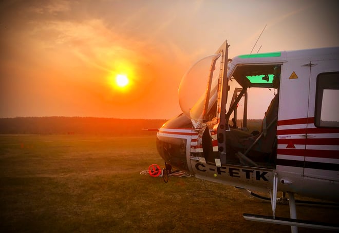
(Helicopters with bucketing mechanisms are vital to our wildland firefighting operations, June 18, 2023.)
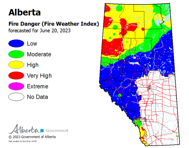
To see the forecasted fire danger click here, updates daily at 3:00 PM.
ON ALERT
Fire lookouts are on high alert constantly watching for smoke and firefighters in helicopters are assessing potential sightings of wildfires, ready to respond to any new wildfires that may start.
Wildland firefighters urge everyone to be extremely cautious when out in the Forest Protection Area. Check your winter burns, and comply with fire bans and OHV restrictions.
SMOKY CONDITIONS
Due to the numerous wildfires in Alberta and other parts of Canada, smoky conditions will continue. Anyone with health concerns should visit Alberta Health Services or call 811 for health advice from Alberta Health Link. Before travelling check www.511.Alberta.ca for information the latest road conditions or closures. Visit www.firesmoke.ca to see where the smoke is coming from and to view wildfires on a map, download the AB Wildfire App or visit the Alberta Wildfire Status Dashboard.
FORT MCMURRAY WILDFIRE UPDATE
Since January 1, 2023 there have been 33 wildfires in the Fort McMurray Forest Area, burning a total of 161,486 hectares (ha).
SWF081 was detected on May 14 and is located near Chipewyan Lakes. This wildfire is classified as out of control and is estimated to be 34,357 hectares in size. This wildfire was caused by lightning.
MWF021 was detected on May 27 and is located near Birch Mountains Wildland Provincial Park. This wildfire is classified as being held and is 14,760 ha in size. This wildfire was caused by lightning.
MWF023 was detected May 28 and is located near Birch Mountains Wildland Provincial Park. This wildfire is classified as being held and is 54,639 ha in size. This wildfire was caused by lightning.
MWF024 was detected May 28 and is located east of Marguerite River Wildland Provincial Park. This wildfire is classified as being held and is approximately 28,204 ha in size. This wildfire was caused by lightning.
MWF025 was detected May 28 and is located approximately 7 km north of Fort Chipewyan. This wildfire is classified as being held and is approximately 60,568 ha in size. This wildfire was caused by lightning.
As of 6 pm last night, we were able to get the southern flank of the wildfire 100 per cent controlled. This means that this wildfire no longer poses a threat to the community of Fort Chipewyan, Allison Bay, Dog Head, or the Fort Chipewyan airport.
Currently, there is a total of 160 people working on this wildfire, which includes firefighters, structure protection personnel and contractors. They are supported by helicopters conducting bucketing operations and heavy equipment. We also have firefighting personnel from Australia and America that are assisting in operations. We are so thankful and appreciate all the assistance we have received from the local community, across Alberta and internationally.
The Firetack training course was completed for seven Fort Chipewyan locals and they will start working on the fireline over the next few days. A trainer was brought into Fort Chipewyan so that locals who wanted to get certified or re-certified could do so and help with this wildfire.
A phased re-entry has begun for Fort Chipewyan, click here for more information.
For the most recent map of MWF025, click here.
MWF026 was detected May 28 and is located northeast of Marguerite River Wildland Provincial Park. This wildfire is classified as being held and is approximately 1,705 ha in size. This wildfire was caused by lightning.
MWF030 was detected on June 4 and is located near La Butte Creek. This wildfire is classified as being held and is 7.4 ha in size. This wildfire was caused by lightning.
MWF031 was detected on June 4 and is located northeast of Fort Fitzgerald. This wildfire is classified as under control and is approximately 3 ha in size. This wildfire was caused by lightning.
Mutual-aid wildfires:
MSZ001 is located on the Alberta/Saskatchewan border, just south of Lake Athabasca. This wildfire is classified as being held and is approximately 75 ha in size.
MNZ001 is located on the south edge of the Alberta/Wood Buffalo National Park border. This wildfire is classified as being held and is approximately 2,595 ha.
To view active wildfires across Alberta, click here.
Check out the RMWB website for additional information.
FIRE BAN AND OHV RESTRICTION IN EFFECT
A fire ban and OHV restriction is in effect within the Fort McMurray Forest Area due to extreme fire danger.
Under this fire ban:
- All existing Fire Permits are suspended (or cancelled)
- No new Fire Permits will be issued
Prohibited:
- All outdoor wood fires are banned, including wood campfires on public lands, wood campfires on private land and provincial campgrounds
- Backyard firepits
- BBQ charcoal briquettes
- The use of fireworks and exploding targets
- The recreational use of off-highway vehicles (OHV) on public lands, including designated OHV trails
Allowed:
- Propane/natural gas-powered appliances
- Open flame oil devices (e.g., turkey deep fryers, tiki torches)
- Indoor wood fires contained within a device with a chimney and spark arrestor
- All appliances must be CSA approved and used per manufacturer’s standards
- Indigenous people when using an OHV for traditional purposes. Traditional purposes are hunting, fishing, and trapping – including the use of an OHV to travel to the location(s) for these purposes.
- Essential industry-related activities requiring the use of OHVs.
- Off-highway vehicle use is still permitted on private lands.
If you see a wildfire, report it immediately by calling 310-FIRE.
The fire ban and OHV restriction will remain in effect until conditions improve.
PROVINCIAL WILDFIRE UPDATE
Since January 1, 2023 in the Forest Protection Area, there have been 645 wildfires burning a total of 1,445,987 ha.
WILDFIRE DASHBOARD
The wildfire dashboard provides up-to-date wildfire information at the click of a button. This interactive tool displays important statistics on the number of active wildfires in the Forest Protection Area of Alberta, sizes, locations, suspected causes and more.
The dashboard builds on the former wildfire status map by displaying the most frequently accessed information in one convenient location.
CONTACT

Websites:
Alberta Wildfire, Alberta Fire Bans, FireSmart in Alberta, Alberta Emergency Alerts, Air Quality Health Index
Wildfire Smoke and Your Health, 511 Road Reports, and Emergency Preparation.
Social Media:
Join the conversation on
![]()
![]()
![]()
Apps:
Alberta Wildfire App for Apple or Android and Alberta Fire Bans App for Apple or Android.