

WILDFIRE DANGER
The wildfire danger is EXTREME in the Fort McMurray Forest Area north of Lake Athabasca. The wildfire danger is HIGH in the Fort McMurray Forest Area south of Lake Athabasca. Please be very cautious when recreating outdoors as we are entering an uptrend where wildfires can ignite easily and spread quickly.
A FIRE RESTRICTION is in effect for the Fort McMurray Forest Area north of Lake Athabasca to the Northwest Territories border.
The FIRE ADVISORY for the Fort McMurray Forest Area south of Lake Athabasca has now been cancelled, visit Alberta Fire Bans for more information.
To view a map of Fire Restrictions across the Forest Protection Area, click here.
Report wildfires immediately by calling 310-FIRE (3473).
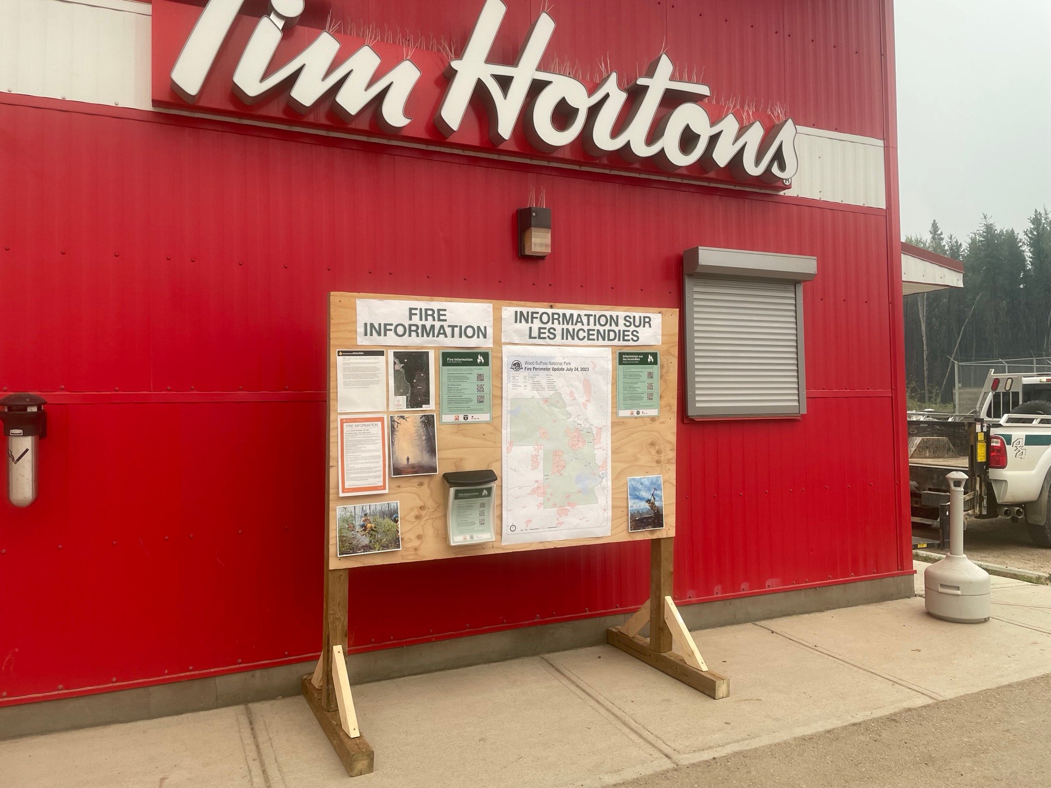
Wildfire information boards have been set up at various locations throughout Fort Smith. Go check out the boards at the Petro-Canada, the Recreation and Community Centre and Kaeser's for updates. To view a digital map of all fires around Fort Smith and Fort Fitzgerald, click here. (July 27, 2023).
FORT MCMURRAY WILDFIRE UPDATE
Since January 1, 2023 there have been 56 wildfires in the Fort McMurray Forest Area, burning a total of approximately 263,315 hectares (ha).
MWF021 was detected on May 27 and is located approximate 38 km south of Wood Buffalo National Park. This wildfire is classified as being held and is 14,760 ha in size. This wildfire was caused by lightning.
MWF023 was detected May 28 and is located near Birch Mountains Wildland Provincial Park. This wildfire is classified as being held and is 54,639 ha in size. This wildfire was caused by lightning.
MWF024 was detected May 28 and is located east of Marguerite River Wildland Provincial Park. This wildfire is classified as being held and is approximately 28,454 ha in size. This wildfire was caused by lightning.
MWF025 was detected May 28 and is located approximately 7 km north of Fort Chipewyan. This wildfire is classified as being held and is approximately 79,364 ha in size. This wildfire was caused by lightning.
This wildfire no longer poses a threat to the community of Fort Chipewyan, Allison Bay, Dog Head, or the Fort Chipewyan airport. 80 per cent of the entire wildfire perimeter is controlled, which includes the entire south perimeter.
For the most recent map of MWF025, click here.
MWF026 was detected May 28 and is located northeast of Marguerite River Wildland Provincial Park. This wildfire is classified as being held and is approximately 1,705 ha in size. This wildfire was caused by lightning.
MWF030 was detected on June 4 and is located near La Butte Creek. This wildfire is classified as being held and is 7.4 ha in size. This wildfire was caused by lightning.
MWF034 was detected on June 24 and is classified as under control at 15 hectares. This wildfire was caused by lightning.
MWF035 was detected on June 24 and is classified as under control at 4.5 hectares. This wildfire was caused by lightning.
MWF039 was detected on June 29 and is located within Birch Mountains Wildland Provincial Park but has crossed over into the Slave Lake Forest Area. This wildfire is classified as being held and is approximately 15,200 ha in size. This wildfire was caused by lightning.
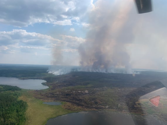
MWF043 was detected on June 30 and is approximately 20 km southeast of Fort Fitzgerald. This wildfire is classified as out of control and is approximately 105,530 ha in size. This wildfire was caused by lightning. To view actual locations of the wildfire, visit the wildfire dashboard. To view a digital map of this fire click here, or to see all fires around Fort Smith and Fort Fitzgerald, click here.
Today, we have a total of 138 personnel, which is comprised of 75 firefighters, 16 overhead staff, and 31 support staff. Additionally, we have eight helicopters. A fire camp and incident command post is established in Smith's Landing First Nation to support this wildfire. Airtankers are available if required.
We saw extreme fire activity yesterday and fire growth was significant, however; the wildfire did not come any closer to Fort Fitzgerald or Fort Smith. Today, there was a significant amount of smoke around the incident command post.
Similar to yesterday, we have helicopters bucketing on key locations along the wildfire perimeter. We have our 20-person Alberta unit crew continuing their work along the west side of the perimeter just southwest of Myers Lake. They are working to remove the fuel between Myers Lake and an old burn from last year with the intent to stop the wildfire from spreading towards the northwest. We have another crew working along a north portion of the perimeter, which they are also working to connect to an old burn from last year.
A structure protection unit (SPU) crew is continuing to set up sprinkler systems in the event that SPU is needed in surrounding communities. Crews are also setting up and maintaining structural protection on values identified to be at risk on the east side of the fire as well as around Fort Fitzgerald and along the Slave River. These systems can be set up in advance and then activated if the wildfire starts to get close to the structures being protected. Sprinklers are only activated when wildfire managers believe the structures could be in immediate risk. This limits the amount of time and effort required by SPU to go back in and refuel the pumps, which needs to happen approximately every 12 hours to ensure they continue to function properly.
Once a wildfire burns around a structure that has been protected, a crew will go out to the value at risk and ensure that all hotspots are extinguished several meters into the burned area. Once they are confident that the structure is safe, they will demobilize and reallocate that equipment to another value to protect.
Tomorrow, we expect similar conditions as today, with a high of 27 degrees Celsius with 30 per cent relative humidity. Winds are forecasted to come from the southeast-south at 10-15 km/h. Only a 40 per cent chance of 1-2 mm of precipitation tomorrow. Based on the forecast, we should not be entering crossover conditions, which would suggest moderate fire behaviour. There's a greater chance of rain on Tuesday and we continue to have additional resources and airtankers available if required.
To find more information on wildfires in Wood Buffalo National Park, click here. To view wildfires in Northwest Territories, visit their interactive map and website by clicking here.
For wildfire smoke forecasts and see where it's originating from, you can visit firesmoke.ca and click on the interactive map.
MWF050 was detected on July 6 and is located approximately 5 km east of the Slave Lake Forest Area border and approximately 28 km south of Birch Mountains Wildland Provincial Park. This wildfire is classified as under control at approximately 60.80 ha in size. This wildfire was caused by lightning.
Mutual-aid wildfires:
ANT003 (SS022) was discovered on July 5, 2023 and is located approximately 25 km north of the Northwest Territories/Alberta border. It is approximately 68,535 hectares in size and is classified as out of control. To view a digital map of this fire click here, or to see all fires around Fort Smith and Fort Fitzgerald, click here.
ANT003 (SS022) is a wildfire in Northwest Territories that is approximately 25 km from the NWT/Alberta border. (July 29, 2023)
We experienced significant fire growth yesterday but this growth not towards Fort Smith or Fort Fitzgerald. Additionally, some of this fire growth was from a successful ignition operation that was completed last night. This operation was to connect a portion of the west flank of the wildfire to the Slave River. This work should decrease the chance that the wildfire could jump the Slave River.
Similar to yesterday, there is one structure protection crew who is assessing the area looking for structures to be protected and developing a plan for what equipment may be required. There are also two ignition specialists that are looking for additional ignition opportunities if conditions and resources permit a controlled burn. To assist those resources, we have a total of four helicopters: three helicopters are used for the assessments and one heavy helicopter is bucketing along the southwest flank of the wildfire.
Experienced wildfire managers will keep their eye on smoke and visibility, as that can impact operations if it is too thick to safely fly. Today, as expected, heavy smoke is in the air around the incident command post that is impacting visibility.
To view more information, visit the Town of Fort Smith website.
A precautionary evacuation notice has been issued for the Town of Fort Smith, click here for more info.
MSZ001 is located on the Alberta/Saskatchewan border, just south of Lake Athabasca. This wildfire is classified as being held and is approximately 75 ha in size.
MNZ001 is located on the south edge of the Alberta/Wood Buffalo National Park border. This wildfire is classified as being held and is approximately 2,595 ha.
To view active wildfires across Alberta, click here.
PROVINCIAL WILDFIRE UPDATE
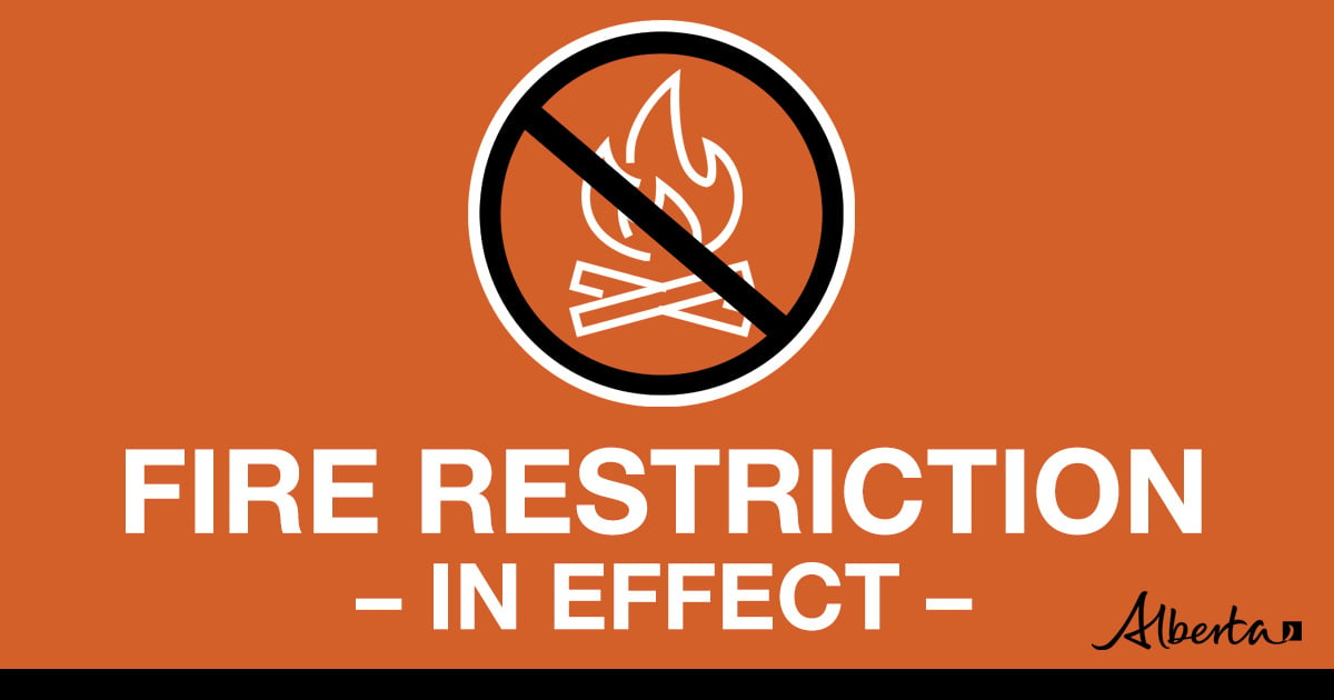
FIRE RESTRICTION IN EFFECT
A Fire Restriction remains in effect for the Fort McMurray Forest Area north of Lake Athabasca to the Northwest Territories border.
Under this restriction:
- Existing fire permits are restricted, suspended or cancelled and no new fire permits will be issued.
- Safe wood campfires within fire rings in campgrounds are allowed.
Prohibited:
- All outdoor wood fires are banned on public lands, including backcountry and random camping areas.
- The use of fireworks and exploding targets is also prohibited.
Allowed:
- Safe wood campfires on private lands and in provincial campgrounds.
- Backyard fire pits, charcoal briquette barbeques.
- Propane/ natural gas-powered appliances.
- Indoor wood fires contained within a device with a chimney and spark arrestor.
- Cooking, warming and lighting devices – all devices must be CSA approved and used as per manufacturer’s standards.
Click here, for the Fire Restriction factsheet.
If you see a wildfire, report it immediately by calling 310-FIRE.
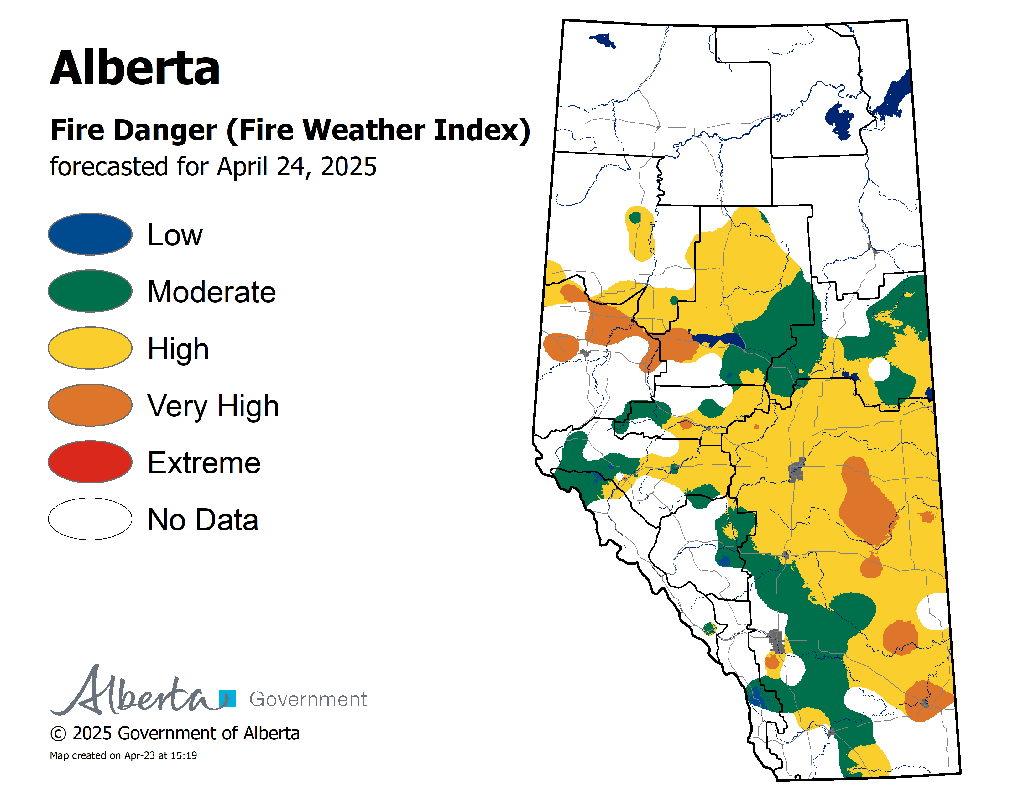
To see the forecasted fire danger click here, updates daily at 3:00 PM.
ON ALERT
Fire lookouts are on high alert constantly watching for smoke and firefighters in helicopters are assessing potential sightings of wildfires, ready to respond to any new wildfires that may start.
Wildland firefighters urge everyone to be extremely cautious when out in the Forest Protection Area. Check your winter burns, and comply with fire bans and OHV restrictions.
.png?width=570&height=299&name=WF_Social-images%20(5).png)
CAMPFIRE SAFETY
Remember to check www.albertafirebans.ca for fire advisories, bans or restrictions in your area or destination. If you are camping in a provincial or national park, check the rules and guidelines and be sure to follow them for your safety and the safety of other campers.
Safe wood campfires - should be within a metal, brick, or rock fire ring.
They are required to:
- be on rock, gravel, sand, or another non-combustible surface that extends at least one metre around the fire
- have a responsible person in attendance to keep fire under control at all times and extinguish before leaving
- have enough water on hand to extinguish the fire. Safe wood campfires on private lands include private land campgrounds and private land recreation areas.
Always let the fire burn down before you plan to extinguish it. Spread the embers within the fire pit, then add water or loose dirt and stir. Repeat until your campfire is cool to the touch. You should not be able to feel any heat from the ashes.
OHV SAFETY
If you plan on riding OHVs in the Forest Protection Area of Alberta, you can reduce the risk of your vehicle causing a wildfire by following these simple steps:
- Before you ride, clean out hot spots and remove debris from your machine.
- After riding through muskeg or tall grass, stop and remove any build-up from your machine.
- Carry firefighting equipment such as a small shovel, collapsible pail or fire extinguisher.
- Wash your OHV and keep it clean; do not wash in streams and creeks.
- Make sure your muffler and spark arrestor are working properly.
- Stop frequently. Take the time to knock debris from your machine’s hot spots. If the debris is smouldering, soak it, stir it, and soak it again to make sure it is extinguished.
For more information, see Off-highway vehicles: Wildfire prevention tips.
EXPLODING TARGETS AND FIREWORKS
The Forest and Prairie Protection Act and associated regulations applies to the shooting, ignition or detonation of exploding targets and fireworks on public lands and private lands located within the FPA.
A Forest Officer from the local forest area office may grant written permission to shoot, ignite or detonate exploding targets or fireworks in the FPA. Written permission of exploding targets and fireworks is based on current wildfire danger and managed on a case-by-case basis.
A fire advisory, restriction, ban or forest closure may prohibit or limit use of exploding targets and fireworks during high wildfire hazard situations within the FPA. Check Alberta Fire Bans or the mobile phone app for the latest information.
WILDFIRE DASHBOARD
The wildfire dashboard provides up-to-date wildfire information at the click of a button. This interactive tool displays important statistics on the number of active wildfires in the Forest Protection Area of Alberta, sizes, locations, suspected causes and more.
The dashboard builds on the former wildfire status map by displaying the most frequently accessed information in one convenient location.
CONTACT

Websites:
Alberta Wildfire, Alberta Fire Bans, FireSmart in Alberta, Alberta Emergency Alerts, Air Quality Health Index
Wildfire Smoke and Your Health, 511 Road Reports, and Emergency Preparation.
Social Media:
Join the conversation on
![]()
![]()
![]()
Apps:
Alberta Wildfire App for Apple or Android and Alberta Fire Bans App for Apple or Android.