

WILDFIRE DANGER
The wildfire danger is VERY HIGH for south of Lake Athabasca and EXTREME for north of Lake Athabasca within the Fort McMurray Forest Area. Fort Smith's fire danger is considered EXTREME.
A Fire Advisory remains in effect for the Fort McMurray Forest Area. See details below.
Please be very cautious when recreating outdoors as we are entering a drying trend where wildfires can ignite easily and spread quickly.
Report wildfires immediately by calling 310-FIRE (3473).
EVACUATION ORDERS
Highway 5 is currently closed due to wildfire activity. Click here, for more highway closure information.
The Regional Municipality of Wood Buffalo (RMWB) has declared a state of local emergency and issued an evacuation order for the community of Fort Fitzgerald. Click here for more information.
The Chief and Council of Smith's Landing First Nation has declared a state of local emergency and issued an evacuation order. Click here, for more information.
The Town of Fort Smith has declared a state of local emergency and issued an evacuation order for residents within the municipality and surrounding areas. Click here, for more information.
For information on Northwest Territories evacuations click here.
For more information and related links, please see MNZ003 below.
SMOKY CONDITIONS
Due to the numerous wildfires in Alberta and other parts of Canada, smoky conditions will continue. Anyone with health concerns should visit Alberta Health Services or call 811 for health advice from Alberta Health Link. Before travelling check www.511.Alberta.ca for information the latest road conditions or closures. Visit www.firesmoke.ca to see where the smoke is coming from and to view wildfires on a map, download the AB Wildfire App or visit the Alberta Wildfire Status Dashboard.
WILDFIRE OF NOTE
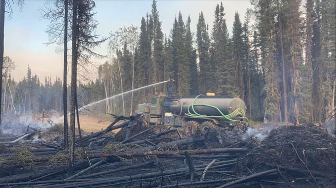
Heavy equipment including water trucks support firefighters to search for and extinguish hotspots on the Wood Buffalo Complex (August 24, 2023).
Wood Buffalo Complex (previously Parks Canada Fire 7, Alberta Wildfire MNZ003, and NWT SS069):
For the most recent map, click here.
UPDATE: No significant growth was observed today and no evening update will be available. We'll provide a new update before noon tomorrow.
If you have evacuated, DO NOT return. This is an active wildfire operation area and is dangerous for residents and first responders if people start coming back before it’s safe. The Wood Buffalo Complex is managed under Unified Command with the Government of Northwest Territories, Parks Canada, and Alberta Wildfire.
The Wood Buffalo Complex is currently 471,217 hectares in size and is classified as OUT OF CONTROL.
The complex continued to see active fire behaviour yesterday primarily along the east and southern edges. With today’s forecast we are expecting fire growth towards the north northwest.
The low laying smoke kept the relative humidity higher again yesterday by shading the sun from the wildfire. This helped keep the temperature from rising and drying out the burnable fuels like branches, needles, and other vegetation. Firefighters observe increased fire behaviour in the afternoon due to increased winds and when some of the smoke lifted, which caused the wildfire to spot over some of the containment lines. These areas include along the Foxholes Road, an area east of Connie’s road near Highway 5 and on the south side of Highway 5 between Thebacha Road and Bell Rock. Firefighters, heavy equipment, and helicopters with buckets continue to work on containing these areas.
There are 376 personnel which includes 86 pieces of heavy equipment, 24 helicopters and 150 firefighters and structure protection personnel responding to the Wood Buffalo Complex today. Firefighters continue to work in priority areas, assisted by helicopters and heavy equipment to prevent the spread towards communities.
Weather:
Today, the forecast calls for 26 C and a relative humidity of 33 per cent with winds from south southeast 15 km/h, gusting up to 35 km/h.
Tomorrow, the forecasted high is 30 C and a relative humidity of 30 per cent. Winds from the south 10 km/h, gusting to 25 km/h.
The forecast for early next week calls for hot dry conditions with mostly easterly winds, which is conducive to extreme fire behaviour.
Today’s Objectives:
The team will work to contain the north and east sides of the wildfire using firefighters, equipment and aerial resources, as long as safe working conditions allow.
Helicopters continue to bucket in key locations along the wildfire perimeter where fire activity starts to pick up if visibility allows.
Ignition Operations:
Ignition specialists continue to look for opportunities for planned ignition operations. Conducting controlled burns are a great tool that firefighters use to remove the available fuel, bringing the wildfire to a containment line like a dozer guard or natural break like a river or a road. This removes the likelihood of the wildfire spreading further.
Work Completed and Yesterday’s Fire Activity:
Distance Disclaimer* These distances may have changed because there are several different ways of measuring and sometimes visibility and smoke can impact the accuracy of a distance measurement. Because this wildfire is such a dynamic incident, these distances are subject to change at any time, and we will do our best to update it as often as possible to keep everyone informed. Our distances are measured from the point on the fire line that is closest to the nearest residence within the cluster of houses the community.
Thebacha
- After receiving an updated fire perimeter map, the wildfire is approximately 3.3 km from Thebacha.*
- Yesterday when smoky skies cleared in the late afternoon, we saw extreme fire behaviour in the area of the fire closest to Thebacha. Structure protection was turned on as a precautionary measure.
- With yesterday afternoon’s cleared skies and gusty winds the fire jumped an area of Connie’s Road. Helicopters worked to bucket the area to contain the spread.
- Approximately 10 km of dozer guard has been completed along the fire line south of the Thebacha Road and Highway 5 junction, working east towards Pine Lake Road.
- Heavy equipment has tied the fire guard along Thebacha Road into the river at the north end.
- Heavy equipment widened the east side of the south end of Thebacha road and tied it into the river as an extra layer of protection for communities to the east.
Bell Rock Subdivision
- After receiving an updated fire perimeter map, the wildfire is approximately 2.4 km away from Bell Rock.*
- A dozer guard was established around the subdivision of Bell Rock on the south side of Highway 5.
- An additional dozer guard was established on the west side of Bell Rock, north of Highway 5.
- Crews also strengthened the containment line that is currently south of Highway 5 and south of Bell Rock. They are continuing to do this work east towards Fort Smith.
Fort Smith
- After receiving an updated fire perimeter map, the wildfire is approximately 3.4 km from Fort Smith.*
- Dozer crews continue to work west from Pine Lake Road strengthening dozer guards towards the wildfire perimeter, moving towards Fort Smith. Heavy equipment will continue to work to complete this guard.
- Structural protection crews continue to check the equipment installed around town.
- Upgrading of the old Fort Smith community guard has been completed and is now a 15 blade wide (100 m) guard that has been scraped down to mineral soil. This community guard extends from West 40 (on Highway 5) to Pine Lake Road, just south of Border Town.
- Airport Guards - Dozer guards have been constructed extending south, north, and west of the airport. The western guard connects to the nuisance grounds. The southern guard is connected into Fort Smith community guard.
- Structure protection has been installed at the airport fire camp.
Extensive additional work has been done around town for sprinkler systems and FireSmart work. For more information on these efforts, see the Fort Smith Protective Services Facebook page.
Border Town
- After receiving an updated fire perimeter map, the wildfire is approximately 5.3 km away from Border Town.*
- A fire guard was established along the powerline and along Kaeser’s Canal.
- Sprinkler lines have been set up along Kaeser’s Canal.
- An additional dozer guard was established from the edge of the Fort Smith community guard to Highway 5 towards the golf course.
- Structure protection has been installed at the field of dreams fire camp.
- After receiving an updated fire perimeter map, the wildfire is approximately 6.4 km away from the closest residence in Halfway.*
- Structure protection has been installed on all known residences in Halfway.
- The wildfire is approximately 3.1 km from the closest residence in town.*
- The north flank of the fire closest to Fort Fitzgerald showed active fire behaviour yesterday. Helicopters and firefighters were working in this area to contain the spread.
- A dozer crew continued to work to finish securing the southerly fire guard that had been breached on August 21.
- The wildfire crossed over Pine Lake Road and was burning on either side of the bridge near Salt River Day use area and Fish Camp. Structural protection sprinklers were turned on prior to the fire entering the area.
- Crews are still working the area today to put out spot fires.
- After receiving an updated fire perimeter map, the wildfire is approximately 7 km away from Hay Camp.*
- Crews are monitoring the proximity of the wildfire to Hay Camp and are assessing the need and developing a plan for structure protection.
State of Emergency:
The Town of Fort Smith and Fort Fitzgerald have declared a STATE OF LOCAL EMERGENCY and it remains under an EVACUATION ORDER. The ORDER has been issued for public safety.
Highway 5 is currently closed from Hay River to Fort Smith due to safety concerns and limited visibility. Click here for highway closure information.
Additional Information:
Other Fires in Wood Buffalo National Park.
All other fires in Wood Buffalo National Park are being actively monitored and do not pose a risk to public safety at this time. Parks Canada will continue to monitor and action fires as required. For more information visit Wood Buffalo National Park wildfire updates.
For additional information on the efforts being done in the Town of Fort Smith visit their protective services facebook page or the Town of Fort Smith webpage.
For information on all other wildfires visit the respective webpages:
- Wood Buffalo National Park wildfire updates
- Northwest Territories fire information
- Alberta Wildfire Status Dashboard
For up-to-date road conditions, visit GNWT Highway Conditions
Report any wildfires or suspicious smoke in Alberta to 310-FIRE, in Northwest Territories to 1-877-NWTFIRE, and in Wood Buffalo National Park to 867-621-0136.

FIRE ADVISORY IN EFFECT
A fire advisory is in effect for the entire Fort McMurray Forest Area due to continued hot and dry conditions which will increase the fire behaviour potential.
Under this advisory:
- Existing fire permits are still valid but may be suspended or cancelled if warm, dry weather continues
- The issuing or suspension of new permits is left to the discretion of a forest officer until conditions change
- Permits for the use of fireworks and exploding targets will not be issued.
Prohibited
Any burning without a valid fire permit, other than a campfire.
Allowed
- Safe wood campfires (including charcoal briquettes) in backcountry or random camping areas
- Safe wood campfires (including charcoal briquettes) on private lands and in provincial campgrounds
- Backyard fire pits
- Charcoal briquette barbeques
- Gas and liquid powered appliances (stoves and lanterns)
- Open flame oil devices (e.g., turkey deep fryers, tiki torches)
- Catalytic or infrared-style heaters
- Indoor wood fires
Remember to check the hot spots on your Off-Highway Vehicle (OHV) and remove debris before and after use.
Never leave a campfire unattended. Soak it, stir it and soak it again until cool to the touch to ensure it is extinguished.
If you see a wildfire, report it immediately by calling 310-FIRE.
The fire advisory will remain in effect until conditions improve.
FORT MCMURRAY WILDFIRE UPDATE
Since January 1, 2023 there have been 58 wildfires in the Fort McMurray Forest Area, burning a total of approximately 327,492 hectares (ha).
MWF021 was detected on May 27 and is located approximately 38 km south of Wood Buffalo National Park. This wildfire is classified as under control (UC) and is 14,760 ha in size. This wildfire was caused by lightning.
MWF023 was detected May 28 and is located near Birch Mountains Wildland Provincial Park. This wildfire is classified as under control (UC) and is 54,639 ha in size. This wildfire was caused by lightning.
MWF024 was detected May 28 and is located east of Marguerite River Wildland Provincial Park. This wildfire is classified as under control (UC) and is approximately 28,454 ha in size. This wildfire was caused by lightning.
MWF025 was detected May 28 and is located approximately 7 km north of Fort Chipewyan. This wildfire is classified as being held and is approximately 95,491 ha in size. This wildfire was caused by lightning.
This wildfire no longer poses a threat to the community of Fort Chipewyan, Allison Bay, Dog Head, or the Fort Chipewyan airport. Eighty per cent of the entire wildfire perimeter is controlled, which includes the entire south perimeter.
MWF038 was detected on June 29 and is located approximately 6 km north of the Slave Lake/Fort McMurray Forest Area border. This wildfire is classified as under control (UC) and is approximately 569 ha in size. This wildfire was caused by lightning.
MWF039 was detected on June 29 and is located within Birch Mountains Wildland Provincial Park but has crossed over into the Slave Lake Forest Area. This wildfire is classified as under control (UC) and is approximately 15,200 ha in size. This wildfire was caused by lightning.
MWF043 was detected on June 30 and is approximately 20 km southeast of Fort Fitzgerald. This wildfire is classified as being held and is approximately 108,555 ha in size. This wildfire was caused by lightning. To view actual locations of the wildfire, visit the wildfire dashboard.
This wildfire is experiencing decreased fire growth and is not currently moving any closer to Fort Smith or Fort Fitzgerald.
Mutual-aid wildfires:
MNZ001 is located on the south edge of the Alberta/Wood Buffalo National Park border. This wildfire is classified as being held and is approximately 2,595 ha.
PROVINCIAL WILDFIRE UPDATE
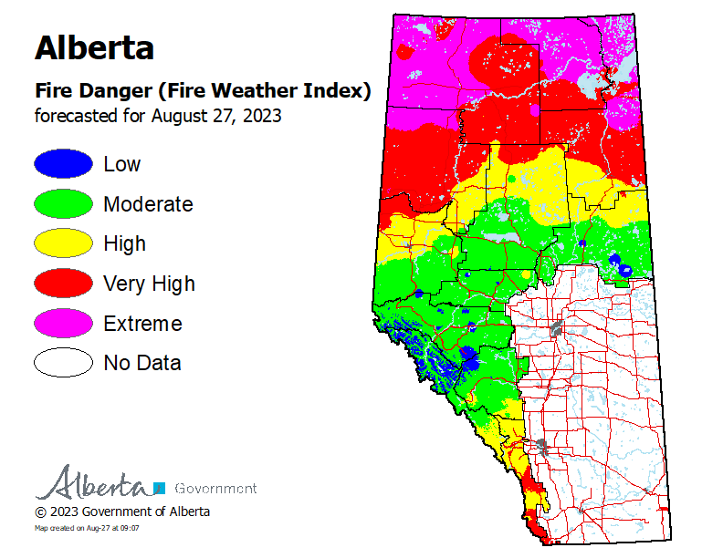 To see the forecasted fire danger click here, updates daily at 3:00 PM.
ON ALERT
Fire lookouts are on high alert constantly watching for smoke and firefighters in helicopters are assessing potential sightings of wildfires, ready to respond to any new wildfires that may start.
Wildland firefighters urge everyone to be extremely cautious when out in the Forest Protection Area. Check your winter burns, and comply with fire bans and OHV restrictions.
.png?width=658&height=345&name=WF_Social-images%20(3).png)
CAMPFIRE SAFETY
Remember to check www.albertafirebans.ca for fire advisories, bans or restrictions in your area or destination. If you are camping in a provincial or national park, check the rules and guidelines and be sure to follow them for your safety and the safety of other campers.
Safe wood campfires - should be within a metal, brick, or rock fire ring.
They are required to:
- be on rock, gravel, sand, or another non-combustible surface that extends at least one metre around the fire
- have a responsible person in attendance to keep fire under control at all times and extinguish before leaving
- have enough water on hand to extinguish the fire. Safe wood campfires on private lands include private land campgrounds and private land recreation areas.
Always let the fire burn down before you plan to extinguish it. Spread the embers within the fire pit, then add water or loose dirt and stir. Repeat until your campfire is cool to the touch. You should not be able to feel any heat from the ashes.
OHV SAFETY
If you plan on riding OHVs in the Forest Protection Area of Alberta, you can reduce the risk of your vehicle causing a wildfire by following these simple steps:
- Before you ride, clean out hot spots and remove debris from your machine.
- After riding through muskeg or tall grass, stop and remove any build-up from your machine.
- Carry firefighting equipment such as a small shovel, collapsible pail or fire extinguisher.
- Wash your OHV and keep it clean; do not wash in streams and creeks.
- Make sure your muffler and spark arrestor are working properly.
- Stop frequently. Take the time to knock debris from your machine’s hot spots. If the debris is smouldering, soak it, stir it, and soak it again to make sure it is extinguished.
For more information, see Off-highway vehicles: Wildfire prevention tips.
EXPLODING TARGETS AND FIREWORKS
The Forest and Prairie Protection Act and associated regulations applies to the shooting, ignition or detonation of exploding targets and fireworks on public lands and private lands located within the FPA.
A Forest Officer from the local forest area office may grant written permission to shoot, ignite or detonate exploding targets or fireworks in the FPA. Written permission of exploding targets and fireworks is based on current wildfire danger and managed on a case-by-case basis.
A fire advisory, restriction, ban or forest closure may prohibit or limit use of exploding targets and fireworks during high wildfire hazard situations within the FPA. Check Alberta Fire Bans or the mobile phone app for the latest information.
WILDFIRE DASHBOARD
The wildfire dashboard provides up-to-date wildfire information at the click of a button. This interactive tool displays important statistics on the number of active wildfires in the Forest Protection Area of Alberta, sizes, locations, suspected causes and more.
The dashboard builds on the former wildfire status map by displaying the most frequently accessed information in one convenient location.
CONTACT
Websites:
Alberta Wildfire, Alberta Fire Bans, FireSmart in Alberta, Alberta Emergency Alerts, Air Quality Health Index
Wildfire Smoke and Your Health, 511 Road Reports, and Emergency Preparation.
Social Media:
Join the conversation on
![]()
![]()
![]()
Apps:
Alberta Wildfire App for Apple or Android and Alberta Fire Bans App for Apple or Android.