

WILDFIRE DANGER
The wildfire danger is VERY HIGH for the Fort McMurray Forest Area north of Lake Athabasca and MODERATE south of Lake Athabasca. The fire restriction for the area north of Lake Athabasca has been removed. Please be very cautious when recreating outdoors as we are entering a drying trend where wildfires can ignite easily and spread quickly.
Report wildfires immediately by calling 310-FIRE (3473).
EVACUATION ORDERS
Highway 5 is currently closed due to wildfire activity. Click here, for more highway closure information.
For more information on the wildfire situation in Wood Buffalo National Park, click here
The Regional Municipality of Wood Buffalo (RMWB) has declared a state of local emergency and issued an evacuation order for the community of Fort Fitzgerald. Click here for more information.
The Chief and Council of Smith's Landing First Nation has declared a state of local emergency and issued an evacuation order. Click here, for more information.
The Town of Fort Smith has declared a state of local emergency and issued an evacuation order for residents within the municipality and surrounding areas. Click here, for more information.
For information on Northwest Territories evacuations click here.
For more information and related links, please see MNZ003 below.
SMOKY CONDITIONS
Due to the numerous wildfires in Alberta and other parts of Canada, smoky conditions will continue. Anyone with health concerns should visit Alberta Health Services or call 811 for health advice from Alberta Health Link. Before travelling check www.511.Alberta.ca for information the latest road conditions or closures. Visit www.firesmoke.ca to see where the smoke is coming from and to view wildfires on a map, download the AB Wildfire App or visit the Alberta Wildfire Status Dashboard.
WILDFIRE OF NOTE
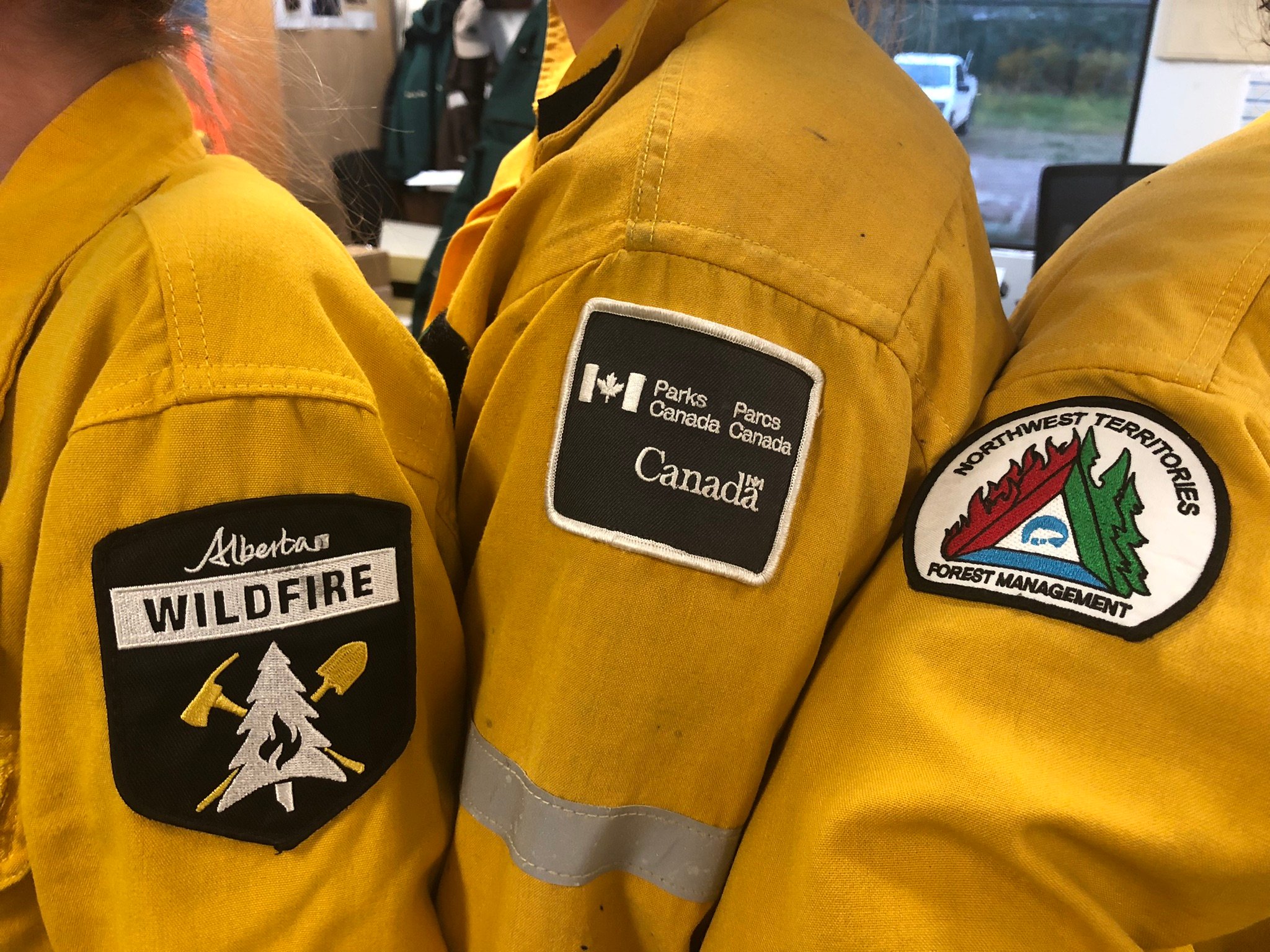
Patches representing each agency that is now under Unified Command for the Wood Buffalo Complex (August 16, 2023).
Fire Information Update – Aug 19, 2023 @ 1000 hrs
Wood Buffalo Complex (previously Parks Canada Fire 7, Alberta Wildfire MNZ003, and NWT SS069):
As of the evening of August 16, the Government of Northwest Territories, Parks Canada, and Alberta Wildfire have made the decision to enter Unified Command. Unified Command means that there is shared responsibility of command among all agency Incident Commanders.
This decision was made because the wildfire that was originally in Wood Buffalo National Park breached the border to the Northwest Territories and Alberta. Once the wildfire crossed jurisdictional boundaries, multiple agencies started working in close quarters and establishing Unified Command will help keep objectives and communications clear. This creates a safer environment to work on the wildfire as all agencies know where all resources are working. This also allows for better utilization of resources so that operations can work in tandem, rather than working around each other.
Wood Buffalo Complex is currently 408,803 hectares in size. At its closest, it is approximately 4km south of Fort Smith, NWT and 6km south of Fort Fitzgerald, AB. Thanks to the increased humidity, light rain and a change in wind direction, the Wood Buffalo Complex wildfire has had minimal growth over the past four days and has given us the opportunity to make progress on the wildfire.
Collectively, there are 250 personnel, 55 pieces of heavy equipment and 25 helicopters responding to the Wood Buffalo Complex today. These essential first responders remain in Fort Smith to work on the wildfire.
Over the coming days, crews will work to complete a continuous control line using mechanical guards, sprinkler lines and natural features that runs south of Highway 5 from Salt River all the way to Fort Fitzgerald. Structural protection personnel will finish work in the Bell Rock area today and will begin setting up in the Tamarack area. In the coming days, teams will work towards having all structural protection or natural control lines around all values at risk between Salt River and Fort Fitzgerald.
Crews tested the opportunity to conduct a strategic micro-ignition yesterday near Highway 5 and Salt River, however relative humidity and cooler temperatures did not provide the necessary conditions to conduct this work. The team will continue to look for opportunities to gently bring the fire to natural fire break features. Removing fuel prior to an approaching fire can slow down the spread of fire once it joins up with the burned area.
It remains unsafe for residents to return to Fort Smith and Fort Fitzgerald. The Town of Fort Smith and Fort Fitzgerald have declared a STATE OF LOCAL EMERGENCY and it remains under an EVACUATION ORDER. The ORDER has been issued for public safety. Highway 5 is currently closed from Hay River to Fort Smith due to safety concerns from fire activity and limited visibility. Click here for highway closure information.
Please visit the Smith’s Landing First Nation’s Facebook for EVACUATION information: Smith's Landing First Nation.
Please visit the Fort Smith website for up-to-date emergency planning information: Town of Fort Smith.
Frequently Asked Questions:
Does Fort Smith have power?
The critical infrastructure in town continues to have power, supplied by the auxiliary system as the main plant has been shut down. Power has been shut off west of Trout Street. Yesterday cell phone service was restored after lines had been damaged near Enterprise. Other critical resources such as potable water and emergency health services are in place.
When will you be able to return home?
We understand that this is a difficult time for all of you. Being evacuated from your homes and the ongoing threat from wildfires is extremely stressful. The goal of Parks Canada, the Government of the NWT, Alberta Wildfire and the Town of Fort Smith is to do our best to make it possible for you to safely return to your community.
We want to thank everyone who has taken the difficult step to leave their homes. We also want you to know how important it is that you and your families remain in the safe places that have been provided for you. Knowing you and your families are out of harm’s way allows us to direct our focus and efforts to protecting the communities, homes and cabins that mean so much to you.
We appreciate your desire to return home is very strong, but please be aware that the current crisis has not passed, and the situation remains critical, not just in the Fort Smith area but throughout the South Slave Region. The area will remain under evacuation order until the threat from fire has passed.
Weather:
Today’s forecasted high is 20 degrees Celsius with relative humidity of 45 percent, with winds coming from the west-northwest at 15km/h gusting 30 to 35 km/h.
Additional Information
For information on all wildfires within Wood Buffalo National Park, visit https://parks.canada.ca/wbnp-fire.
For information on all wildfire within Northwest Territories, visit Northwest Territories fire information.
For information on all wildfires within Alberta, visit Alberta Wildfire Status Dashboard.
For up-to-date road conditions, visit the GNWT Highway Conditions website: https://www.dot.gov.nt.ca/Highways.
08182023.jpg?width=570&height=1013&name=55c8baec-2363-417f-8b58-a8a0b414d536%20(003)08182023.jpg)
Helicopters and crews continue to work along eastern flanks to limit fire growth on the Wood Buffalo Complex (August 17, 2023).
FORT MCMURRAY WILDFIRE UPDATE
Since January 1, 2023 there have been 58 wildfires in the Fort McMurray Forest Area, burning a total of approximately 326,072 hectares (ha).
MWF021 was detected on May 27 and is located approximately 38 km south of Wood Buffalo National Park. This wildfire is classified as under control (UC) and is 14,760 ha in size. This wildfire was caused by lightning.
MWF023 was detected May 28 and is located near Birch Mountains Wildland Provincial Park. This wildfire is classified as under control (UC) and is 54,639 ha in size. This wildfire was caused by lightning.
MWF024 was detected May 28 and is located east of Marguerite River Wildland Provincial Park. This wildfire is classified as under control (UC) and is approximately 28,454 ha in size. This wildfire was caused by lightning.
MWF025 was detected May 28 and is located approximately 7 km north of Fort Chipewyan. This wildfire is classified as being held and is approximately 95,491 ha in size. This wildfire was caused by lightning.
This wildfire no longer poses a threat to the community of Fort Chipewyan, Allison Bay, Dog Head, or the Fort Chipewyan airport. Eighty per cent of the entire wildfire perimeter is controlled, which includes the entire south perimeter.
MWF026 was detected May 28 and is located northeast of Marguerite River Wildland Provincial Park. This wildfire is classified as under control (UC) and is approximately 1,705 ha in size. This wildfire was caused by lightning.
MWF030 was detected on June 4 and is located near La Butte Creek. This wildfire is classified as being held and is 7.4 ha in size. This wildfire was caused by lightning.
MWF038 was detected on June 29 and is located approximately 6 km north of the Slave Lake/Fort McMurray Forest Area border. This wildfire is classified as under control (UC) and is approximately 569 ha in size. This wildfire was caused by lightning.
MWF039 was detected on June 29 and is located within Birch Mountains Wildland Provincial Park but has crossed over into the Slave Lake Forest Area. This wildfire is classified as under control (UC) and is approximately 15,200 ha in size. This wildfire was caused by lightning.
MWF043 was detected on June 30 and is approximately 20 km southeast of Fort Fitzgerald. This wildfire is classified as being held and is approximately 108,555 ha in size. This wildfire was caused by lightning. To view actual locations of the wildfire, visit the wildfire dashboard.
This wildfire is experiencing decreased fire growth and is not currently moving any closer to Fort Smith or Fort Fitzgerald.
Mutual-aid wildfires:
ANT003 (SS022) was discovered on July 5, 2023 and is located approximately 25 km north of Fort Smith. It is approximately 85,584 ha in size and is classified as out of control. To view a digital map of this fire click here, or to see all fires around Fort Smith and Fort Fitzgerald, click here.
This wildfire is experiencing decreased fire growth and is not currently moving any closer to Fort Smith or Fort Fitzgerald.
Currently, all resources have been pulled from this wildfire to assist with MNZ003 (please see more information below).
MSZ001 is located on the Alberta/Saskatchewan border, just south of Lake Athabasca. This wildfire is classified as being held and is approximately 75 ha in size.
MNZ001 is located on the south edge of the Alberta/Wood Buffalo National Park border. This wildfire is classified as being held and is approximately 2,595 ha.
PROVINCIAL WILDFIRE UPDATE
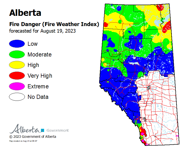
To see the forecasted fire danger click here, updates daily at 3:00 PM.
ON ALERT
Fire lookouts are on high alert constantly watching for smoke and firefighters in helicopters are assessing potential sightings of wildfires, ready to respond to any new wildfires that may start.
Wildland firefighters urge everyone to be extremely cautious when out in the Forest Protection Area. Check your winter burns, and comply with fire bans and OHV restrictions.
CAMPFIRE SAFETY
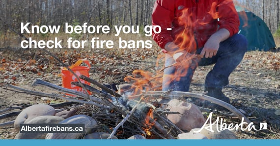
Remember to check www.albertafirebans.ca for fire advisories, bans or restrictions in your area or destination. If you are camping in a provincial or national park, check the rules and guidelines and be sure to follow them for your safety and the safety of other campers.
Safe wood campfires - should be within a metal, brick, or rock fire ring.
They are required to:
- be on rock, gravel, sand, or another non-combustible surface that extends at least one metre around the fire
- have a responsible person in attendance to keep fire under control at all times and extinguish before leaving
- have enough water on hand to extinguish the fire. Safe wood campfires on private lands include private land campgrounds and private land recreation areas.
Always let the fire burn down before you plan to extinguish it. Spread the embers within the fire pit, then add water or loose dirt and stir. Repeat until your campfire is cool to the touch. You should not be able to feel any heat from the ashes.
OHV SAFETY
If you plan on riding OHVs in the Forest Protection Area of Alberta, you can reduce the risk of your vehicle causing a wildfire by following these simple steps:
- Before you ride, clean out hot spots and remove debris from your machine.
- After riding through muskeg or tall grass, stop and remove any build-up from your machine.
- Carry firefighting equipment such as a small shovel, collapsible pail or fire extinguisher.
- Wash your OHV and keep it clean; do not wash in streams and creeks.
- Make sure your muffler and spark arrestor are working properly.
- Stop frequently. Take the time to knock debris from your machine’s hot spots. If the debris is smouldering, soak it, stir it, and soak it again to make sure it is extinguished.
For more information, see Off-highway vehicles: Wildfire prevention tips.
EXPLODING TARGETS AND FIREWORKS
The Forest and Prairie Protection Act and associated regulations applies to the shooting, ignition or detonation of exploding targets and fireworks on public lands and private lands located within the FPA.
A Forest Officer from the local forest area office may grant written permission to shoot, ignite or detonate exploding targets or fireworks in the FPA. Written permission of exploding targets and fireworks is based on current wildfire danger and managed on a case-by-case basis.
A fire advisory, restriction, ban or forest closure may prohibit or limit use of exploding targets and fireworks during high wildfire hazard situations within the FPA. Check Alberta Fire Bans or the mobile phone app for the latest information.
WILDFIRE DASHBOARD
The wildfire dashboard provides up-to-date wildfire information at the click of a button. This interactive tool displays important statistics on the number of active wildfires in the Forest Protection Area of Alberta, sizes, locations, suspected causes and more.
The dashboard builds on the former wildfire status map by displaying the most frequently accessed information in one convenient location.
CONTACT
Websites:
Alberta Wildfire, Alberta Fire Bans, FireSmart in Alberta, Alberta Emergency Alerts, Air Quality Health Index
Wildfire Smoke and Your Health, 511 Road Reports, and Emergency Preparation.
Social Media:
Join the conversation on
![]()
![]()
![]()
Apps:
Alberta Wildfire App for Apple or Android and Alberta Fire Bans App for Apple or Android.