Please ensure you fully extinguish your campfire. Soak it, stir it and soak it again until the ashes are cool to the touch. Never leave your campfire unattended.
If you plan to burn it, get your free fire permit. Apply online or contact your local forestry office.
If you see smoke or flame in the forest and suspect it's a wildfire, call 310-FIRE.
The smoke lingering in our forest area is not caused by local wildfires. If you want to know where the smoke is being produced, you can visit FireSmoke.ca and click on the interactive map. (August 26, 2023).
Bold indicates new or important information.
This update is best viewed on a web browser or the AB Wildfire Status App.
Previous Edson Forest Area Updates - Click here.
EDSON FOREST AREA WILDFIRE UPDATE
The wildfire danger in the Edson Forest Area remains LOW. This means that fire can ignite but would have difficulty spreading to deeper vegetation layers or larger fuels, such as trees. Creeping ground fires would not travel very fast as the grass is green and there's sufficient moisture in the fine fuels. This is due to the the lower temperatures, higher relative humidity and recent precipitation. You can view the provincial wildfire danger map and learn more about how to interpret fire danger by clicking here.
Since January 1, 2023, there have been 79 wildfires in the Edson Forest Area burning a total of 234,558 ha. The last reported wildfire was on August 11. There are currently six active wildfires, all are classified as under control. One is human-caused, four are caused by lightning and one remains under investigation.
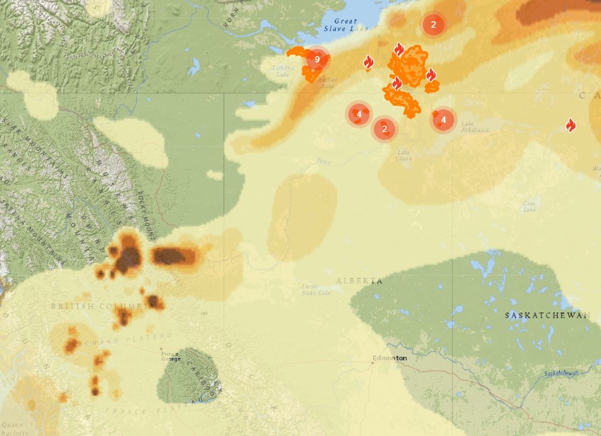
Visit our website and click on the interactive map to view active wildfires, their locations and stats on the wildfire dashboard.
PROVINCIAL WILDFIRE UPDATE
Since January 1, 2023 in the Forest Protection Area, there have been 983 wildfires burning a total of 1,701,434 ha. Last year, there were 997 wildfires by this date with a total of 128,384 ha burnt. The 5 year average on this date is 969 wildfires with a total of 205,826 ha burned.
FULLY EXTINGUISH YOUR CAMPFIRE & NEVER LEAVE IT UNATTENDED
If you have a campfire, ensure you place it in an area away from vegetation and out of the wind. It's always best to have your campfire in a metal ring but if that's not possible, place it on bare minimal soil.
Be sure to never leave your campfire unattended and keep a sufficient amount of water nearby in case sparks land in nearby vegetation or your campfire escapes it's ring.
Before you leave, you must soak your campfire, stir the ashes and soak it again until it's cool to the touch. Campfires can burn into the ground and resurface at a later date which could cause a wildfire.
FARM AND ACREAGE | WILDFIRE PREVENTION
FIELDS AND PASTURELAND | FEED STORAGE AREAS
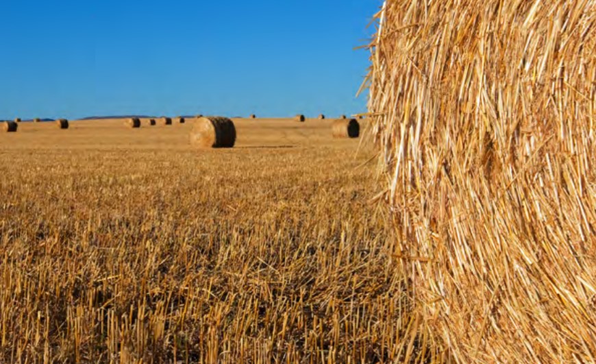
Dry bales are a magnet for sparks and embers and are usually one of the first things to ignite as a wildfire approaches. No matter how you store bales, once they ignite, the fire spreads quickly and is difficult to control or extinguish.
Fires can start in stored hay from radiant heat or spontaneous combustion. Spontaneous combustion usually occurs within six weeks of baling, but can occur in old hay and straw as well. Fire can occur in loose or baled hay and straw and is most often caused by excessive moisture. One of the best ways to prevent this is to ensure that the hay is cured to the proper moisture content before baling.
To minimize the spread of fire from straw and hay bales to the house or outbuildings, store bales a good distance away from any structures. The area between the bales and buildings should be maintained by reducing the amount of vegetation, preferably down to mineral soil or gravel. If you have grass in this area, it’s critical that it be kept mowed as short as possible. It is a good idea to store your winter supply of bales in a couple of different locations to minimize loss in the event of a fire. Use the bales closest to the house and outbuildings during the feeding season. That way when spring comes, you have a larger buffer between the house, outbuildings and the bales.
It’s important to clean up all the old hay and straw that accumulates in storage areas from broken bales and bale bottoms freezing down over the winter. Haul it out on the pasture for the livestock to pick through, spread it over the field like manure, or let your livestock graze on it.
For more information, visit the Farm and Acreage Magazine online by clicking here.
 Plan ahead in the fall for wildfire safety this coming spring.
BEFORE YOU BURN IT, GET YOUR FIRE PERMIT
Wildfire season in Alberta is from March 1 until October 31. During wildfire season, you are required to have a fire permit if you plan on burning in the Forest Protection Area, with the exception of a campfire. To request your free fire permit, contact the local forest area: (780) 723-8527 or you can request your permit using the new, convenient online fire permit portal. To view the video, click here.
PEMBINA WILDFIRE COMPLEX | EWF031, EWF039
EWF031 was detected on May 4, is 201,913 ha in size and determined to be caused by lightning.
EWF039 was detected on May 5, is 165 ha in size and determined to be human-caused.
DEEP CREEK COMPLEX | WCU001, WCU002, EWF035
WCU001 was detected on April 29 and 6,284 ha in size.
WCU002 was detected on April 29 and 2,478 ha in size.
EWF035 was detected on May 5, is 19,672 ha in size and remains under investigation.
WILDHAY WILDFIRE COMPLEX | EWF037, EWF040
EWF037 was detected on May 6, is 12,073 ha in size and determined to be caused by lightning.
EWF040 was detected on May 6, is 578 ha in size and determined to be caused by lightning.
The wildfires will continue to be monitored for activity and be actioned by local wildland firefighting crews when needed. A reclamation plan has begun and equipment have started working on identified areas. This work is anticipated to continue into the winter months.
All of these wildfires are now classified as under control which means that firefighters have this fire fully contained and it is not expected to grow. None of these wildfires pose a threat to any communities or properties, including the Town of Edson. To learn more about wildfire classifications, click here. To view actual locations of the wildfires, visit the wildfire dashboard.
GENERAL INFORMATION ON WILDFIRES IN OUR AREA
WORK OR RECREATE NEAR WILDFIRE AREAS | We urge residents and members of the public to use extra caution near burnt areas. There are many hazards that may not be visible, like deep burning ash pits and falling trees. Burnt trees are a serious hazard, and trees that may look healthy with green needles or leaves could have burnt out roots under the ground and fall unexpectedly.
UNDERSTANDING WILDFIRE BEHAVIOUR | There are many factors that affect a wildfire and its growth, such as the wind, temperature and the forest fuel moisture conditions. You may have seen the Forestry fire danger signs that are posted around your communities, along highway 16, in Grande Cache on highway 40 and the Edson Forestry warehouse. We set the fire danger based on a number of factors, including the Fire Weather Index (FWI). The FWI is derived from data collected daily at various weather and includes observations of temperature, relative humidity, wind speed, and 24-hour precipitation. The FWI is a system used across Canada to quantify the fire hazard based on forest fuel moisture, temperature, relative humidity and forecasted winds.
Wildfires generally smoulder on and in the ground with very little open flame on low to moderate fire activity days. Creeping surface fire with open flame and the occasional torching tree is typical fire behaviour on moderate days. The days where the fire "picked up" and "took off" were on days when the fire danger was very high to extreme.
UNDERSTANDING WILDFIRE CLASSIFICATIONS | When firefighters classify a wildfire as OUT OF CONTROL, it means that the wildfire is burning and is expected to continue to grow within and possibly outside of its present boundary. The classification of BEING HELD means that under the current weather conditions and the resources available, there will be no unexpected growth, however firefighters anticipate the possibility of a small amount of spread which would be normal on a wildfire of this size. UNDER CONTROL means that the fire is fully contained, firefighters don't except any growth and the next stage would be extinguished. To learn more about wildfire classifications, click here.
Albertans are always asked to use caution when working or recreating in the outdoors:
- Before you burn it, get your fire permit. Fire permits in Alberta.
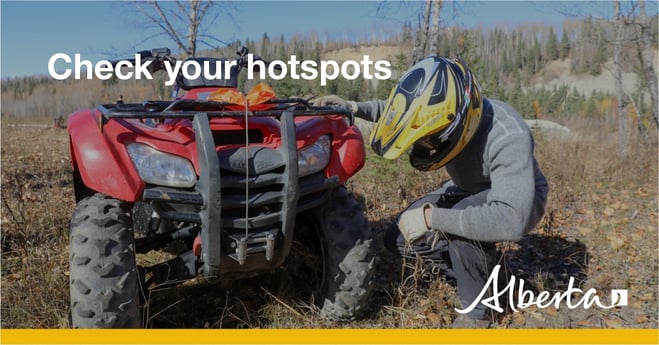
- Clear debris from hot spots on your off-highway vehicle.
- Ensure your campfire is out - soak it, stir it, soak it again.
- Before you head out this weekend, check out the albertafirebans.ca website or download the app to stay informed.
- For road closure information, please visit 511.alberta.ca
- For information regarding smoke in the area, you can visit firesmoke.ca
- NASA FIRMS Fire Information website is a great resource to give an idea of the location of wildfires in the area, but note that the data is based on interpolation and often can make the wildfire look larger then it actually is.
- To view the provincial wildfire danger map, click here.
ALBERTA WILDFIRE INFORMATION
- Subscribe to the Edson Forest Area wildfire update to receive an email when new information is posted.
- Download the Alberta Wildfire App for Apple and Android device.
- Join the conversation on Facebook, Twitter or Instagram.
For more information, please contact: