We urge residents and members of the public to use extra caution near burnt areas. There are many hazards that may not be visible, like deep burning ash pits and falling trees.
Firefighters continue to build containment lines and extinguish hotspots in key areas near communities.
Previous Edson Forest Area Updates - Click here.
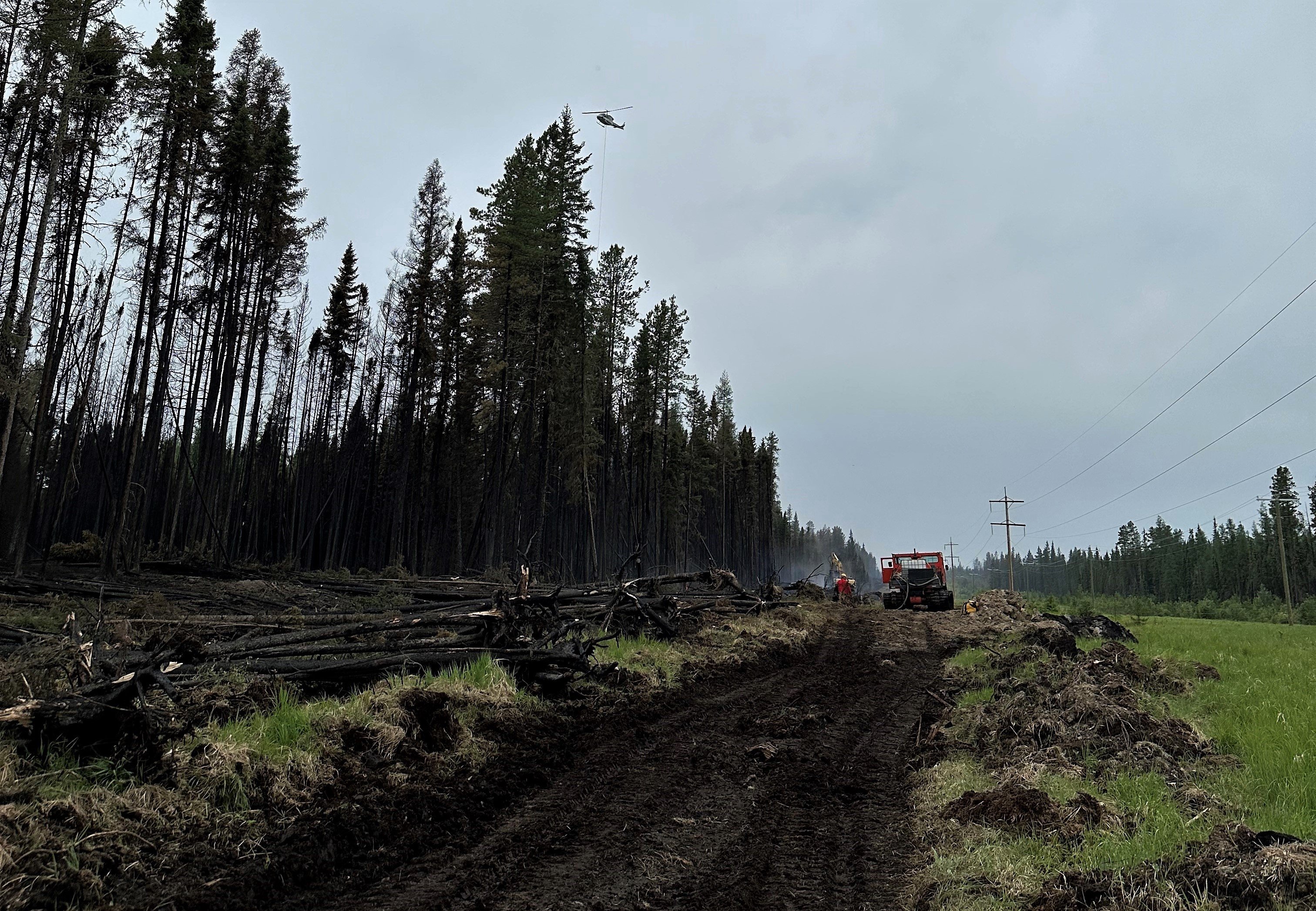
 Firefighters from all over the country and around the world are assisting AB Wildfire with extinguishing hotspots in key locations. There is over 1,000 km of fire perimeter in the Edson Forest Area and firefighters are focused on communities and critical infrastructure. (June 16, 2023).
TO SUBSCRIBE TO THE UPDATES
For those that aren't aware, you can subscribe to these updates (or any other forest area's update) and they'll come directly to your email or as a notification on your phone. You can visit our website, enter your email address and click Instant then Subscribe. You can also download the AB Wildfire Status App, click the "i" at the bottom left, click the bell for notficiations and toggle the Edson Forest Area Update.
NEW WILDFIRE STARTS
Visit our wildfire dashboard to view active wildfires and their stats.
EDSON FOERST AREA | PEMBINA WILDFIRE COMPLEX | EWF031, EWF039
EWF031 was detected on May 4 and is located 18 km west of Lodgepole, 5 km northwest of Brazeau Dam and 1.5 km south of Edson. The fire is classified as out of control and is estimated to be 211, 247 ha in size. Visit our wildfire dashboard to view the perimeter of these wildfires and their stats.
There are 247 firefighters and 65 support staff being shared between the Pembina Complex of fires. There are 72 pieces of heavy equipment, and 19 helicopters assigned to the complex. In addition, 160 structure protection personnel from the Town of Edson and Yellowhead County have integrated with the complex as a structure protection branch to allow for seamless coordination between Alberta Wildfire and the County.
The international contingent of personnel dedicated to the Pembina Complex includes professionals from Australia, New Zealand, South Africa, United States, Alberta, British Columbia and the Yukon. Over the coming days, additional support and resources are expected to arrive in support of these ongoing incidents. An Incident Management Team from Australia has now taken over the Pembina Complex.
Goals at the Pembina Complex remain first responder and public safety. Crews and support staff continue to work diligently and maintain awareness despite the downturn in weather.
Fire Behaviour
Yesterday, the fire received a less than 1 mm of rain. Today’s forecast shows north-westerly winds at 15-20 km/hr with gusts up to 35 km/hr. Heavy amounts of rain and cooler temperatures are forecasted for the next few days. With gusty wind conditions, falling trees remain a risk. Although the fire has received heavy amounts of rain, there is still signs of heat and smoke.
Wet conditions may impact road access to the fireline and safety assessments are ongoing. Yesterday, helicopters bucketed on hotspots within the burn area. Personnel and heavy machinery will be working to create a fire guard around critical areas on the northern parts of the fire. With heavy rain amounts forecasted, fire behaviour continues to be subdued.
Fickle Lake Finger – This area of the fire is approximately 2.5 km east of Fickle Lake and approximately 5 km south of Marlboro.
Personnel are continuing to work closely with structure protection staff from the Yellowhead County to assess and protect values within the Fickle Lake and Marlboro area. Personnel are focusing on assessments triaging, and sprinkler set-up plans. Crews have been patrolling the area to monitor for any hotpots or potential areas of concern. Highway 47 has opened to local traffic only.
Willmore Park Finger – This area of the fire is approximately 1.5 km south of Edson.
Machine guard has been established ahead of the most northern edge of this finger to limit any further growth in this area under current conditions. Crews have extinguished up to 100 feet into the fire perimeter around the fire that crossed over the McLeod River. Crews continue to patrol this area to monitor for hotspots.
Carrot Creek Area – This area of the fire is approximately 6 km south of Highway 16 and approximately 10 km southwest of Carrot Creek.
Planned controlled burn operations in this area will be reevaluated over the coming days when favourable conditions are present. The Carrot Creek lookout tower is now operational. Heavy equipment and personnel are being used to reinforce a dozer guard in the Carrot Creek area.
East side – This area of the fire is approximately 18 km west of Cynthia.
On June 13, increased fire behavior was observed along the east side of the fire, west of Highway 753 and caused approximately 350-hectares of new fire growth to the east, approximately 10 km south of Eta Lake. Aerial resources are responding to hotspots as weather conditions allow. Heavy equipment and personnel continue to build and reinforce dozer guard on the east side of the fire over the next two days. The fire edge remains approximately 18 km to the west of Cynthia.
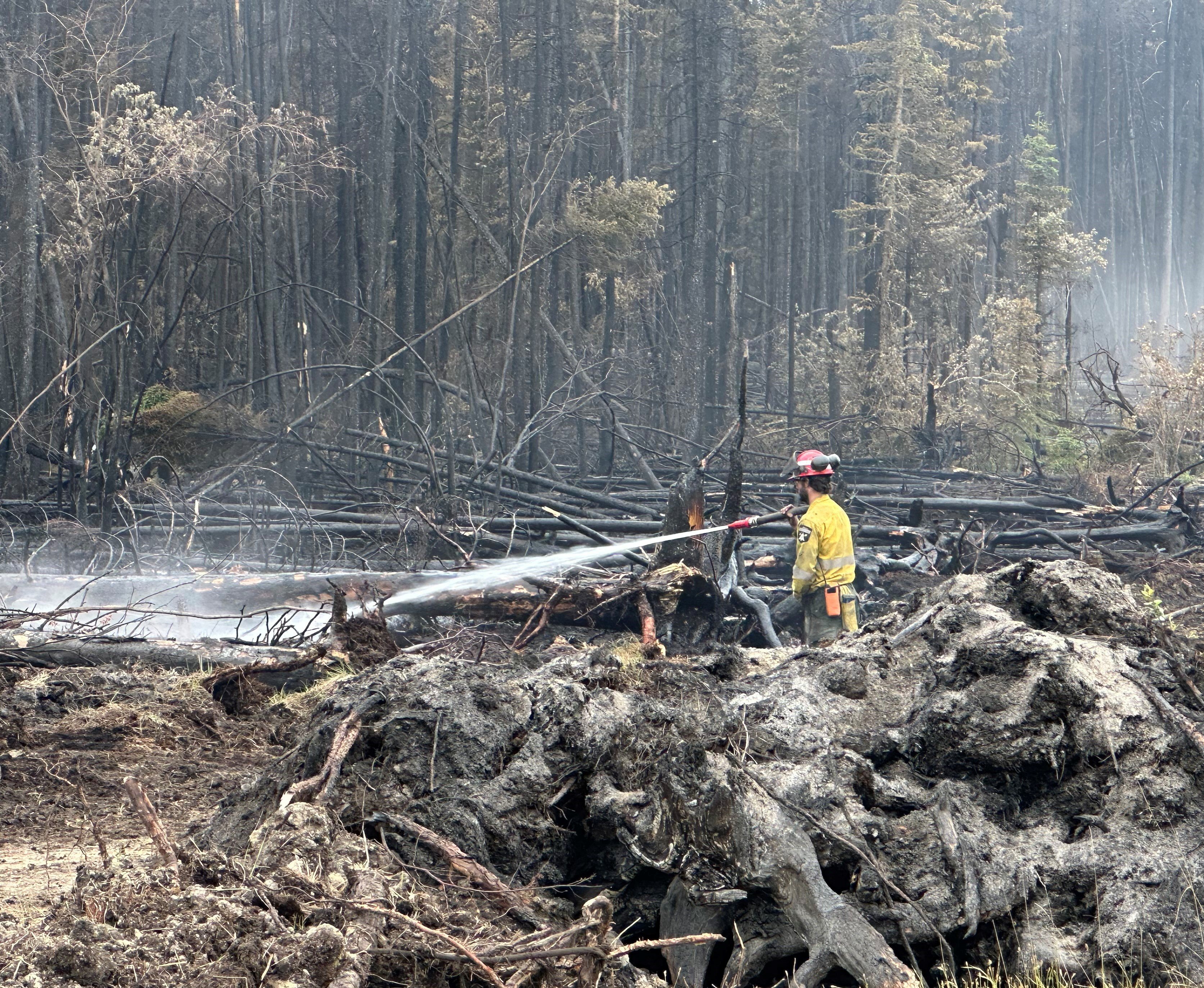
 Wildfire firefighters are starting from fire perimeters and working their way in, searching for and extinguishing hotspots to prevent the spread of the wildfire (June 17, 2023).
ROCKY MOUNTAIN HOUSE FOERST AREA | PEMBINA WILDFIRE COMPLEX | RWF034, RWF040
RWF034 is located near the O'Chiese Reserve and classified as out of control. The fire is currently estimated at 87,492 ha in size.
Personnel and heavy equipment are continuing to put out hotspots along the western side of this fire.
Crews will be making use of the cool temperatures and rainfall to continue reinforcing control lines and identifying concerns within the perimeter. Smoke may still be visible despite rainfall. The perimeter on the west side of the Brazeau Reservoir has remained quiet.
RWF040 is being actively monitored by firefighters and support staff assigned to the complex who can respond if necessary. Personnel continue to work on putting out hotspots within the perimeter. The fire is currently estimated to be 5,089 ha in size and remains classified as out of control.

By: Emma MacDonald, Pembina Complex. Wildfire Information Officer. Yukon Wildland Fire Management. For information related to the Pembina Wildfire Complex please contact: 780-728-5843. Emma MacDonald and Haley Ritchie are part of the Information Team on the Pembina Complex.
EDSON FOREST AREA | DEEP CREEK COMPLEX | WCU001, WCU002, EWF035
WCU001 was detected on April 29, and is now BEING HELD and estimated to be 6,284 ha in size. WCU002 was detected on the evening of April 29, and is now BEING HELD and estimated to be 2,478 ha in size. EWF035 was detected on May 5 and remains classified as out of control and is 19,672 ha in size. To view actual locations of the wildfires, visit the wildfire dashboard.
UNDERSTANDING WILDFIRE CLASSIFICATIONS | When firefighters classify a wildfire as OUT OF CONTROL, it means that the wildfire is burning and is expected to continue to grow within and possibly outside of its present boundary. The classification of BEING HELD means that under the current weather conditions and the resources available, there will be no unexpected growth, however firefighters anticipate the possibility of a small amount of spread.There are 204 firefighters assigned to the Deep Creek Complex, five helicopters, 37 pieces of heavy equipment, and 59 support staff who are part of the incident management team, equipment maintenance and crew supervision (to name a few positions). Additional helicopters and heavy equipment groups are available from the Pembina Complex should they be required on any of the fires within the Deep Creek Complex.
The wildfire complex is expecting a possible 50-75 mm of rain in the next 72 hours. Very high humidity, low temperatures will keep wildfire behaviour low in the coming days, allowing firefighters to make good progress on the fire line. The weather moving in will also unfortunately bring strong gusty winds of up to 55 km/h, kicking up some possible flare ups within the fire perimeter.
WCU001 remains fairly quiet. Members of the Canadian Armed Forces are working alongside AB Wildfire firefighters near highway 16 and the train tracks. They're searching for and extinguishing hotspots with water pumps, hose and hand tools. Their goal is to fully extinguish this wildfire. AB Wildfire firefighters will monitor and respond to any flare ups as needed. Residents and the public may see smoke or flame within the perimeter and this is normal as we work our way around and into the fire.
WCU002 also remains fairly quiet thanks to the work from our various firefighters and the cooler, wet weather we're experiencing. Approximately 16 Alberta Wildfire firetack crew members are working near the Lobstick river on the northwest side of the wildfire. Crews will continue to work in key areas, including in peat farms and cattle fields.
EWF035 is showing some flare ups which will continue to occur within the perimeter of the fire until sufficient precipitation falls on the wildfire. These flare ups will be monitored and actioned accordingly by firefighters.
Firefighting crews and heavy equipment are currently working on the middle section of the western boundary of the wildfire. They're busy building containment line and tying in some of the unburnt areas west of East Bank Road, south of Twp 560. This is to prevent a larger burn from occurring due to the forest fuel types that the wildfire would have available if it took off in that section again.
Crews are also working along the southwest side of the wildfire, searching for and extinguishing hotspots. Same for the southern portion, east of Rg Rd 131 and west of Rg Rd 130.
Heavy equipment has begun reclamation on the northwestern section of the wildfire, removing creek crossings and rolling back disturbed soil. All disturbed containment lines will need to be reclaimed and this work is expected to continue into the fall and possibly into the winter months.
Previous Edson Forest Area Updates - Click here.
By Caroline Charbonneau, Deep Creek Complex. Wildfire Information Officer, AB Wildfire - Edson Forest Area. For information related to the Deep Creek Complex please contact: 780-740-1341.
There are 60 of the 400 South Africans located at our Deep Creek Camp. Singing and dancing keeps up morale and brings them closer together as a team (June 16, 2023).
EDSON FOREST AREA | WILD HAY WILDFIRE COMPLEX | EWF037, EWF040
The Wild Hay Complex is comprised of two wildfires, EWF037 and EWF040. They are both located south of the Little Smoky River, north of the Wild Hay River and east of Hwy 40 north. The complex is 63 km north of Hinton. EWF040 is producing a lot of smoke that can be seen from far away, including from Hinton.
EWF040 remains out of control and was estimated to be 12,073 ha. It escaped its wildfire boundary on June 7 and is burning mostly to north-northwest from its original area and has crossed the the Berland River and is now burning in both our forest area and the Whitecourt Forest Area. Today, firefighters anticipate that the cold front will shift the winds sometime this afternoon and push the fire towards the south.
EWF037 continues to be classified as being held at 578 ha.
GENERAL INFORMATION ON WILDFIRES IN OUR AREA
AREA CHALLENGES | This has been an unprecedented wildfire season; one that has resulted in many challenges for wildfire staff across the province. In response Alberta has been working with our partners to meet the demands for personnel and equipment needed to fight the numerous wildfires we have seen this spring. In the Edson Forest Area we currently have crews and support staff from all over Canada and the world, including U.S.A., Australia, New Zealand and South Africa, B.C., P.E.I., Newfoundland and Ontario.
WORK OR RECREATE NEAR WILDFIRE AREAS | We urge residents and members of the public to use extra caution near burnt areas. There are many hazards that may not be visible, like deep burning ash pits and falling trees. Burnt trees are a serious hazard, and trees that may look healthy that have green needles or leaves could have burnt out roots under the ground and fall unexpectedly. Keep in mind that trees and powerlines could also fall on the road and block your vehicle. Do not approach powerlines as they could be energized.
SMOKE | Lingering smoke can still be visible in some areas and in affected communities. Smoke inversions can trap air near the ground causing dangerous driving conditions and impacting nearby communities. If you have smoke related health concerns, please contact Alberta 811 or visit Alberta Health Services . Visit firesmoke.ca for current and forecasted smoke.
REPORTING WILDFIRES | We always appreciate people calling in to report wildfires but the large volume of calls we are receiving could be diverting our resources away from other essential tasks. As always, call 310-FIRE if you see smoke or flame that looks new and potentially unreported, but assume that large columns of smoke and burned over areas have already been detected and reported. If you or your property are in immediate danger, call 911.
AIRCRAFT NEAR WATER | Depending on the location of a wildfire, firefighting aircraft may need to use water from nearby lakes as a source of water to help fight wildfires. Often, these aircraft arrive without advanced warning. If you are in the water and see an aircraft coming in to collect water, please move within 30 m from the shore so these aircraft can safely resume firefighting efforts. Aircraft are large and require space to collect water, without interference from people and boats. Help us by staying out of the way when aircraft are around. Click here to learn more.
DRONES | The use of recreational drones over wildfires in Alberta is dangerous, illegal and could result in a fine of up to $15,000* for putting aircraft and people at risk. Please give Alberta firefighters the space they need to do their jobs safely. *Transport Canada
WILDFIRE PREPARDNESS | Learn how you can prepare yourself for a wildfire by clicking here.
WILDFIRE INVESTIGATIONS | Wildfires in Alberta are either human-caused or caused by lightning. Every wildfire in Alberta is investigated and the wildfires mentioned remain under investigation.
WILDFIRE CLASSIFICATIONS | To learn more about wildfire classifications, click here.
WILDFIRE MAPS AND BOUNDARIES | Note that wildfire perimeter maps are an estimate based on measurements such as GPS, aerial scanning and satellite imagery. This estimated perimeter can change as more accurate measurements become available. Areas within the fire perimeter may not have been affected by wildfire. Visit our Wildfire Dashboard to view active wildfires and their stats on the wildfire dashboard. Click on "view interactive map". You can choose different basemaps by selecting the four squares icon, or layers by clicking on the three sheets of paper on the top right corner.
**Bold indicates new or important information.

We encourage the public and industry to download the AB Fire Bans app or visit the website to learn more about prohibited and allowed actives under this restriction. If you are looking for information regarding crown land, click on the area you plan to visit and not the nearest town. Be advised that Alberta Parks has it's own set of fire ban levels, please visit their website for more information.
The fire restriction will remain in effect until conditions improve. To view the Alberta Wildfire Fire Ban video, click here.
Albertans are always asked to use caution when working or recreating in the outdoors:
- Before you burn it, get your fire permit. Fire permits in Alberta.
- Clear debris from hot spots on your off-highway vehicle.
- Ensure your campfire is out - soak it, stir it, soak it again.
- Before you head out this weekend, check out the albertafirebans.ca website or download the app to stay informed.
- For road closure information, please visit 511.alberta.ca
- For information regarding smoke in the area, you can visit firesmoke.ca
- NASA FIRMS Fire Information website is a great resource to give an idea of the location of wildfires in the area, but note that the data is based on interpolation and often can make the wildfire look larger then it actually is.
- To view the provincial wildfire danger map, click here.
ALBERTA WILDFIRE INFORMATION
- Subscribe to the Edson Forest Area wildfire update to receive an email when new information is posted.
- Download the Alberta Wildfire App for Apple and Android device.
- Join the conversation on Facebook, Twitter or Instagram.
For more information, please contact: