EVACUATION ORDERS AND ALERTS ARE IN EFFECT WITHIN THE EDSON FOREST AREA. VISIT YOUR COMMUNITY WEBPAGE, SOCIAL MEDIA AND ALBERTA EMERGENCY ALERT FOR MORE INFORMATION.
If you see smoke or flame outside of an active fire area, report it to 310-FIRE. If you or your property is in immediate danger, call 911.
For road closure information, visit Alberta511 or download the app.
Previous Edson Forest Area Updates - Click here
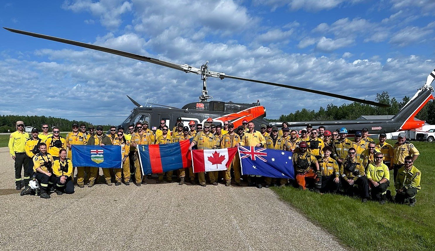
We want to thank all of the many out of province and country resources assisting AB Wildfire in the Edson Forest Area. (June 11, 2023 at 2:00 p.m.).
BE PREPARED & PAY ATTENTION
MESSAGE FROM YOUR COMMUNITIES
For information on evacuation alerts and orders, please visit Alberta Emergency Alert or visit your communities websites and and their social media pages for updates. For evacuation information for Yellowhead County and Town of Edson, contact the info line: 1-833-334-4630.
NEW WILDFIRE STARTS
Visit our wildfire dashboard to view active wildfires and their stats.
PEMBINA WILDFIRE COMPLEX | EWF031, EWF039, RWF034, RWF040
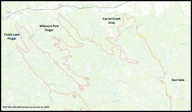
EWF031 was detected on May 4 and is located 18 km west of Lodgepole, 5 km northwest of Brazeau Dam and 1.5 km south of Edson. The fire is classified as out of control and is estimated to be 204,284 ha in size.
There are 224 firefighters and 65 support staff being shared between the Pembina Complex of fires. There are 67 pieces of heavy equipment, and 22 helicopters assigned to the complex.
The international contingent of personnel dedicated to the Pembina Complex includes professionals from Australia, South Africa, United States, Alberta and B.C. Over the coming days, additional support and resources are expected to arrive in support of these ongoing incidents.
Primary objectives at the Pembina Complex remain first responder and public safety. The onsite incident management team continues to work with impacted communities and partners to coordinate response in areas where the wildfire is encroaching on values. Yellowhead County has integrated their structure protection branch to allow for seamless coordination between Alberta Wildfire and the County.
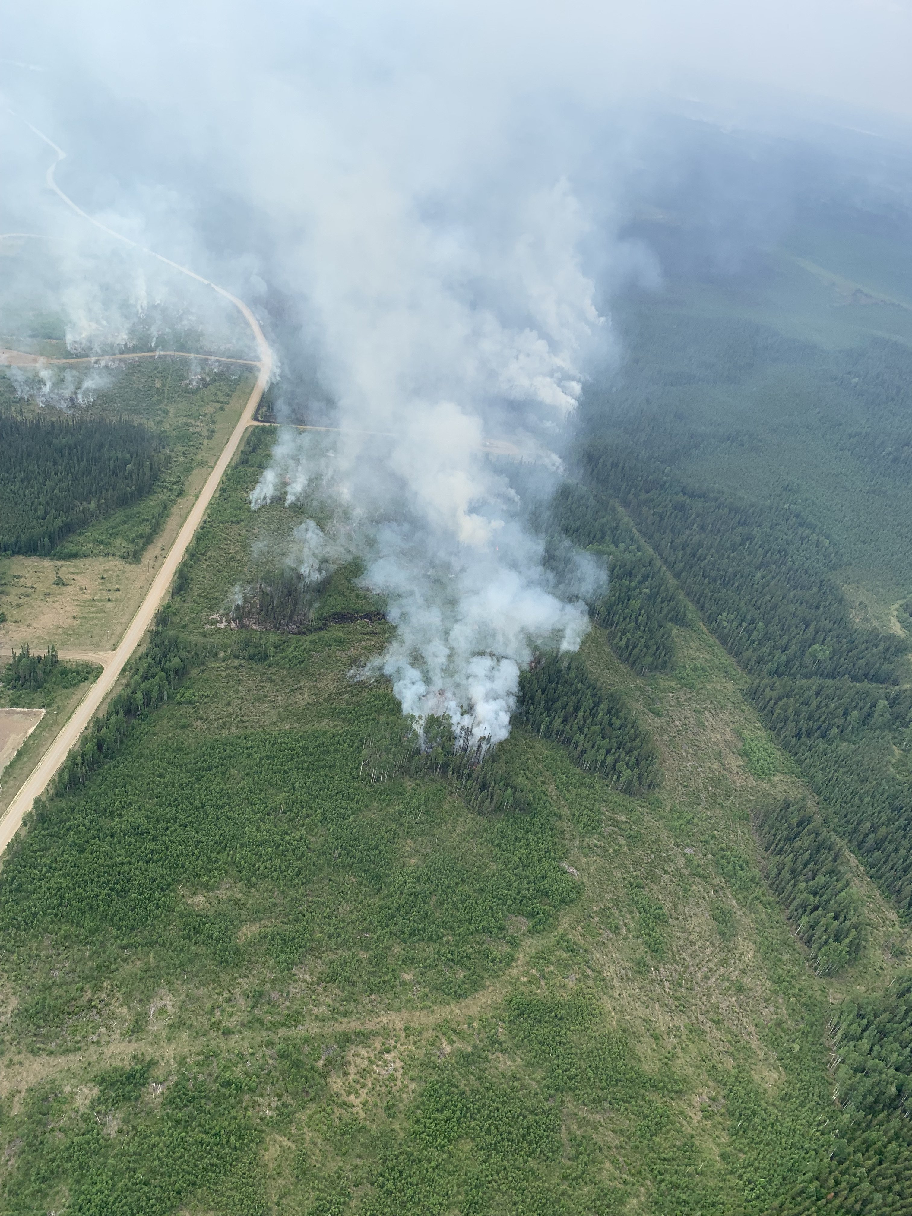
Fire behavior on the east side of EWF031. (June 11).
Fire Behaviour
Yesterday on-site, higher humidity around 45% and temperatures in the low-to-mid 20s provided reduced rates of spread. This allowed an opportunity for ground personnel to re-establish their situational awareness in new areas of the fire where growth occurred over the past 72-hours. Today, temperatures up to 27 degrees are expected and relative humidity will be back down to around 25-35%. Winds today are expected 10-15 km/hr from the southeast shifting to 10-15 km/hr from the northeast into the evening. Tuesday will again be hot and dry until a low develops over Alberta into the evening bringing potentially 15-30 mm of rain through Tuesday night and into Wednesday.
Resources
Crew swing shifts have been established to allow for longer operational coverage on the fireline. Crews will now be working shifts from 6am to 8pm and from 12pm to 2am. This allows crews to work late into the evening when the fire is less aggressive. Beginning Tuesday, a night contingent will begin working through the night allowing for 24/7 suppression activities.
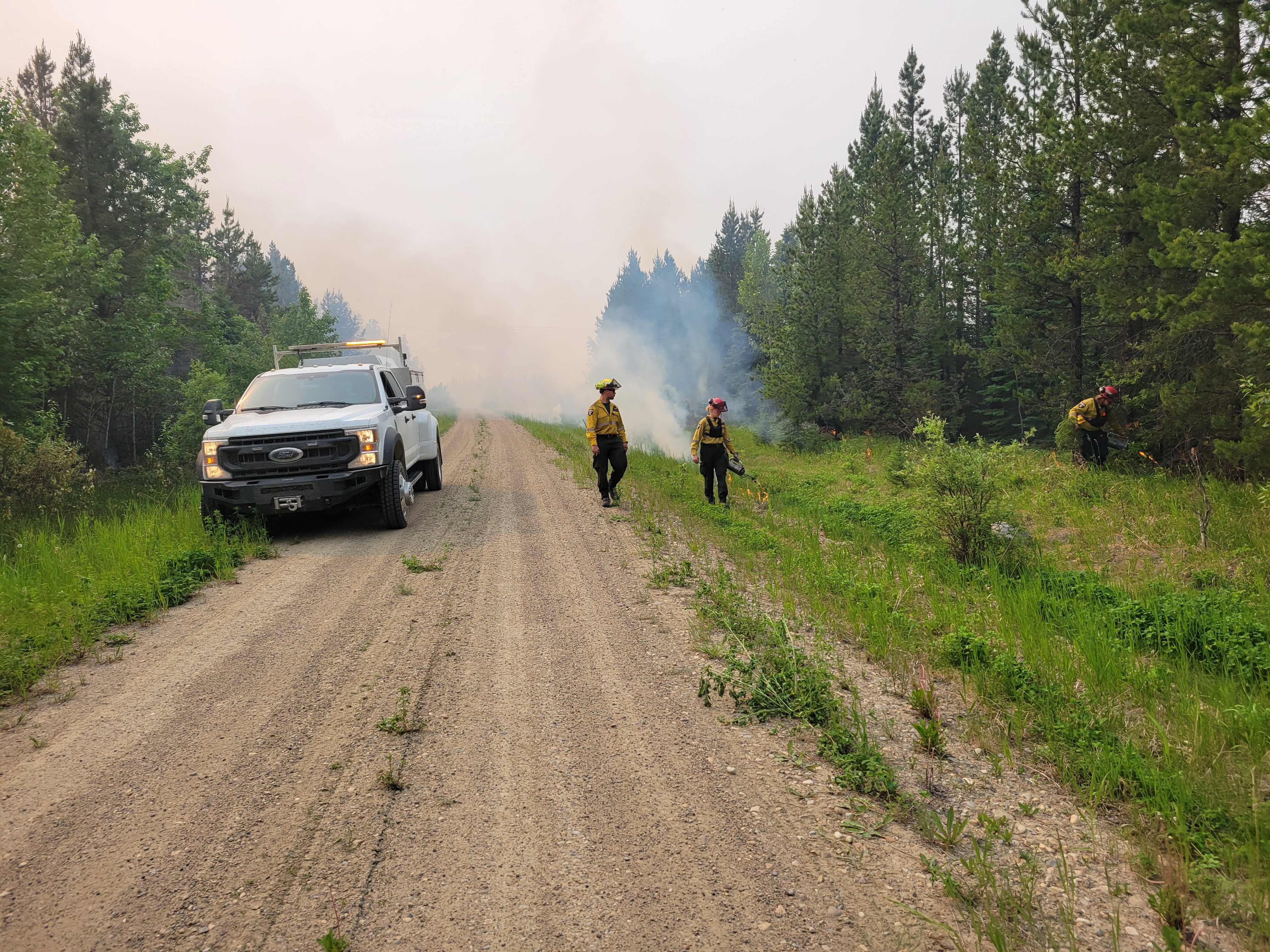
Crews conducting planned ignition operations on EWF031 (June 11).
Fickle Lake Finger – This area of the fire is approximately 2.5 km east of Fickle Lake and approximately 5 km south of Marlboro.
Through the day and into the evening of June 9, this area of the finger grew in the northwest direction, crossing Sundance Road and then progressing across Highway 47. From there, the fire continued to progress parallel and south of the McLeod River on the west side of Highway 47. In a 24-hour timespan on June 9 and through the night, this area of the fire grew by 31 km.
Yesterday, a heavy equipment task force completed guard construction along the west side of this finger from Highway 47 towards the McLeod River. Taking advantage of light northwest winds on-site yesterday, the American hot shot crew carried out planned ignition operations to remove unburned fuels between the west flank and the newly built guard. This ignition operation will allow crews to further secure this area of the fire. Crews will continue to mop up and patrol this flank today to further secure it. On the east side of the finger, fixed-wing retardant airtankers slowed the spread of the fire in anticipation for a heavy equipment task force to build a control line in this area today.
Crews are continuing to work along both Highway 16 and Highway 47 corridors to protect values adjacent to the fire. This includes the protection of power poles and working with local industry to ensure critical infrastructure is maintained.
Further south along this finger, where the fire crossed over Sundance Road, aerial ignition operations will help to contain 12 kms of the fires edge on this western side of the fire. Once the ignitions are completed, crews will be able to safely access the fire’s edge and further secure this area of the fire. This operation will only take place today should conditions be favourable.
Willmore Park Finger – This area of the fire is approximately 1.5 km south of Edson.
On June 9, this finger of the fire progressed 18 km in the northwest direction. Late in the evening, the fire spotted across McLeod River and into Willmore Park. Crews are continuing to work with Yellowhead County and the Town of Edson to patrol and set up structure protection as required ahead of the fire in this area.
Fire that grew north of the McLeod River covers an area of approximately 250 hectares. Machine guard has been established ahead of the most northern edge of this finger to limit any further growth in this area under current conditions. Yesterday, crews extinguished to 100 feet into the fire perimeter around the fire that crossed over the McLeod River. Crews will continue to work in this area today to ensure 100% extinguishment.
Carrot Creek Area – This area of the fire is approximately 6 km south of Highway 16 and approximately 10 km southwest of Carrot Creek.
Yesterday, a heavy equipment group began to work west of Penn West Road to establish guard in anticipation for planned ignition operations along the east flank in this area, north of Kwaz Road. Planned ignition operations in this area will only take place should conditions be favourable over the coming days.
East side – This area of the fire is approximately 18 km west of Cynthia.
Heavy equipment has established control lines west of Highway 753, east of the fire. Crews will continue to work with heavy equipment to further construct a containment line from Tidewater Road moving south towards Rat Creek. A heavy equipment task force also completed a new containment line adjacent to the Brazeau Reservoir where 50 ha had previously grown beyond control lines. This southeast area of the fire, adjacent to the Brazeau Reservoir is anticipated to be secured by the end of the day on June 13.
This area of the fire is approximately 1.5 km south of Edson. (June 12.).
RWF034 is located near the O'Chiese Reserve and classified as out of control. The fire is currently estimated at 87,108 ha in size.
On Friday, approximately 150-hectares of fire crossed the control line on the east side of the Brazeau Reservoir adjacent to Sunchild Road. Heavy equipment was constructed to contain the escaped fire and a water skimmer group was utilized to slow the spread. There is no threat to values at this time and crews will continue to work in this area today. This area of the fire has remained secure over the past 24-hours and work is continuing to positively progress towards containment. Small hot spots continue to be present well within the fire perimeter and do not pose a threat to nearby communities. The perimeter on the west side of the Brazeau Reservoir has remained quiet.
RWF040 is being actively monitored by firefighters and support staff assigned to the complex who can respond if necessary. The fire is currently estimated to be 5,089 ha in size and remains classified as out of control. Infrared scans continue to be completed to help identify residual heat and help crews identify areas to target to ensure full extinguishment to 100 ft into the fire beyond the control lines.
DEEP CREEK WILDFIRE COMPLEX | EWF035, WCU001, WCU002
WCU001 was detected on April 29, remains classified as out of control and is estimated to be 6,284 ha in size. WCU002 was detected on the evening of April 29 and is a mutual aid wildfire located on both sides of Highway 22, north of Highway 16. It is estimated to be 2,478 ha in size and remains classified as out of control. EWF035 was detected on May 5 and is located approximately 8 km north of the Niton Junction. It remains classified as out of control and is 19,672 ha in size.
There are 123 firefighters assigned to the Deep Creek Complex, two helicopters, 33 pieces of heavy equipment, nine water tenders, and 20 overhead staff that are part of the incident management team and crew supervision. Additional helicopters and heavy equipment groups are available from the Pembina Complex should they be required on any of the fires within the Deep Creek Complex. As of yesterday afternoon, the B.C. incident management team who has been managing the Pembina Complex for the past 10-days has assumed command of the Deep Creek Complex.
WCU001 has had no new growth recorded outside the fire perimeter since the last size update. The wildfire zone is located southeast of Entwistle and west over the Pembina River where it spread north and travelled over Highway 16. The wildfire is parallel with Highway 16 and moved further west where it spread just north of Wildwood and now rests at Chip Lake.
WCU002 has had relatively more hot spots than earlier this week. Activity on WCU001 and WCU002 increased yesterday, but firefighters actively worked alongside bucketing helicopters to promptly action them. Work continued to be done north of Wildwood west of highway 22. Firefighters wrapped up the work they were doing alongside the high-volume pump at the cattle field in this area yesterday. Fire crews and heavy equipment were also working near Range Road 91 on WCU001. They began working on the north end of Range Road 91 earlier this week and continue moving southward, making good progress.
A reminder that deep ash pits and burning peat are dangerous. We continue to ask residents to be extra cautious near burnt areas.
We also ask residents to avoid venturing into forested areas that have been recently affected by wildfire as they can present other hazards such as falling trees, as a result of root systems being compromised by fire.
EWF035: The northern portion of the fire is located 2 km east of Shining Bank Lake, reaching north and east across Township Road 560 and as far south as approximately 2 km north of the Niton Junction railway.
The wildfire is south of Township Road 570, has burnt down to the south and continues to a site two kilometers north of the railroad track in Niton Junction. The fire moved across the Range Road 123 and burnt up to the Lobstick River.
Moderate to high winds with significant gusts pushed smoke and fire spread towards the northwest for the last few days. As a result, we have seen some growth on the southwest side of the perimeter, including one very small area that has made its way northwest across McLeod River. This spot can be seen on the new perimeter available for viewing on the dashboard, and is located west of the junction of East Bank Road and Range Road 132. Firefighters have worked in this area over the previous days and there is no concern at this time of the spot growing any further.
Woodlands County Fire Department continues to install structural protection on properties within the alert area as a precautionary measure.
Yellowhead County Fire Department with Alberta Wildfire continues to triage residences with regard to the need for structural protection and are continuing to install sprinklers on some residences north of Niton Junction. Firefighters continue to actively work on areas of the fire that are seeing increased activity while helicopters can be seen dropping water where smoke and flames are most prominent.
Previous Edson Forest Area Updates - Click here.
By: Sarah Hall, Pembina Complex. Wildfire Information Officer, BC Wildfire Service. For information related to the Pembina Wildfire Complex and the Deep Creek Wildfire Complex please contact: 780-728-5843.

WILD HAY WILDFIRE COMPLEX | EWF037 and EWF040
The Wild Hay Complex is comprised of two wildfires, EWF037 and EWF040. They are both located south of the Little Smoky River, north of the Wild Hay River and east of Hwy 40 north. The complex is 63 km north of Hinton. EWF040 is producing a lot of smoke that can be seen from far away, including from Hinton.
EWF040 remains out of control and was estimated to be 12,073 ha. It escaped its wildfire boundary on June 7 and is burning mostly to north-northwest from its original area and has crossed the the Berland River and is now burning in both our forest area and the Whitecourt Forest Area. Today, firefighters anticipate that the cold front will shift the winds sometime this afternoon and push the fire towards the south.
EWF037 continues to be classified as being held at 578 ha.
GENERAL INFORMATION ON WILDFIRES IN OUR AREA
AREA CHALLENGES | This has been an unprecedented wildfire season; one that has resulted in many challenges for wildfire staff across the province. In response Alberta has been working with our partners to meet the demands for personnel and equipment needed to fight the numerous wildfires we have seen this spring. In the Edson Forest Area we currently have crews and support staff from all over Canada and the world, including U.S.A., Australia, New Zealand and South Africa, B.C., P.E.I., Newfoundland and Ontario.
WORK OR RECREATE NEAR WILDFIRE AREAS | We urge residents and members of the public to use extra caution near burnt areas. There are many hazards that may not be visible, like deep burning ash pits and falling trees. Burnt trees are a serious hazard, and trees that may look healthy that have green needles or leaves could have burnt out roots under the ground and fall unexpectedly. Keep in mind that trees and powerlines could also fall on the road and block your vehicle. Do not approach powerlines as they could be energized.
SMOKE | Lingering smoke can still be visible in some areas and in affected communities. Smoke inversions can trap air near the ground causing dangerous driving conditions and impacting nearby communities. If you have smoke related health concerns, please contact Alberta 811 or visit Alberta Health Services . Visit firesmoke.ca for current and forecasted smoke.
REPORTING WILDFIRES | We always appreciate people calling in to report wildfires but the large volume of calls we are receiving could be diverting our resources away from other essential tasks. As always, call 310-FIRE if you see smoke or flame that looks new and potentially unreported, but assume that large columns of smoke and burned over areas have already been detected and reported. If you or your property are in immediate danger, call 911.
AIRCRAFT NEAR WATER | Depending on the location of a wildfire, firefighting aircraft may need to use water from nearby lakes as a source of water to help fight wildfires. Often, these aircraft arrive without advanced warning. If you are in the water and see an aircraft coming in to collect water, please move within 30 m from the shore so these aircraft can safely resume firefighting efforts. Aircraft are large and require space to collect water, without interference from people and boats. Help us by staying out of the way when aircraft are around. Click here to learn more.
DRONES | The use of recreational drones over wildfires in Alberta is dangerous, illegal and could result in a fine of up to $15,000* for putting aircraft and people at risk. Please give Alberta firefighters the space they need to do their jobs safely. *Transport Canada
WILDFIRE PREPARDNESS | Learn how you can prepare yourself for a wildfire by clicking here.
WILDFIRE INVESTIGATIONS | Wildfires in Alberta are either human-caused or caused by lightning. Every wildfire in Alberta is investigated and the wildfires mentioned remain under investigation.
WILDFIRE CLASSIFICATIONS | To learn more about wildfire classifications, click here.
WILDFIRE MAPS AND BOUNDARIES | Note that wildfire perimeter maps are an estimate based on measurements such as GPS, aerial scanning and satellite imagery. This estimated perimeter can change as more accurate measurements become available. Areas within the fire perimeter may not have been affected by wildfire. Visit our Wildfire Dashboard to view active wildfires and their stats on the wildfire dashboard. Click on "view interactive map". You can choose different basemaps by selecting the four squares icon, or layers by clicking on the three sheets of paper on the top right corner.
**Bold indicates new or important information.

We encourage the public and industry to download the AB Fire Bans app or visit the website to learn more about prohibited and allowed actives under this restriction. If you are looking for information regarding crown land, click on the area you plan to visit and not the nearest town. Be advised that Alberta Parks has it's own set of fire ban levels, please visit their website for more information.
The fire restriction will remain in effect until conditions improve. To view the Alberta Wildfire Fire Ban video, click here.
Albertans are always asked to use caution when working or recreating in the outdoors:
- Before you burn it, get your fire permit. Fire permits in Alberta.
- Clear debris from hot spots on your off-highway vehicle.
- Ensure your campfire is out - soak it, stir it, soak it again.
- Before you head out this weekend, check out the albertafirebans.ca website or download the app to stay informed.
- For road closure information, please visit 511.alberta.ca
- For information regarding smoke in the area, you can visit firesmoke.ca
- NASA FIRMS Fire Information website is a great resource to give an idea of the location of wildfires in the area, but note that the data is based on interpolation and often can make the wildfire look larger then it actually is.
ALBERTA WILDFIRE INFORMATION
- Subscribe to the Edson Forest Area wildfire update to receive an email when new information is posted.
- Download the Alberta Wildfire App for Apple and Android device.
- Join the conversation on Facebook, Twitter or Instagram.
For more information, please contact: