
Due to very hot and dry conditions, there is increased wildfire activity on many wildfires in our area. Community leaders are advising residents to BE PREPARED AND PAY ATTENTION.
If you see smoke or flame outside of an active fire area, report it to 310-FIRE. If you or your property is in immediate danger, call 911.
Previous Edson Forest Area Updates - Click here
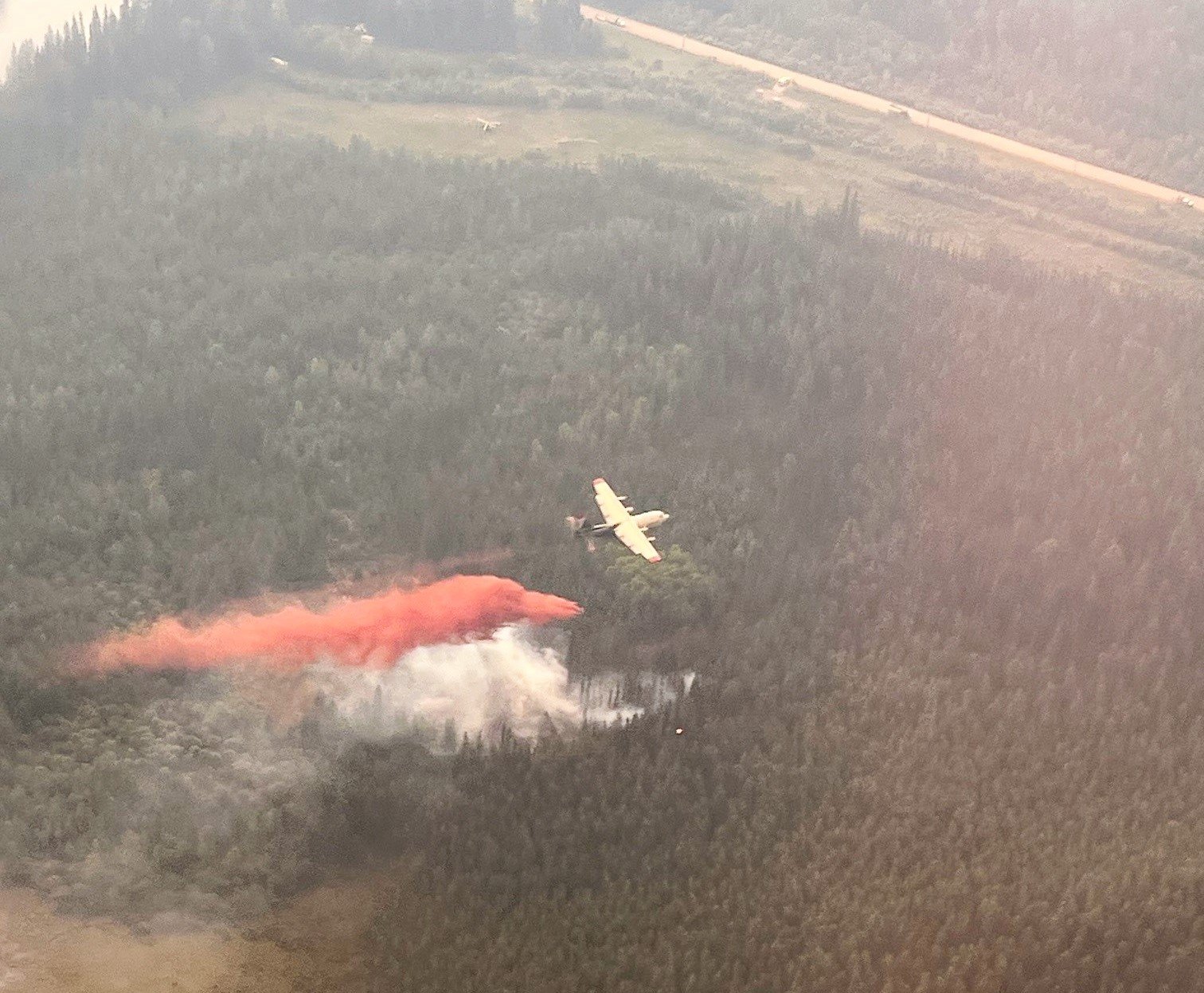 Airtankers are actioning EWF066 located 6 km west of Edson. The fire is moving towards the northwest headed for the McLeod River (June 9, 2023 at 2:00 p.m.).
BE PREPARED & PAY ATTENTION
MESSAGE FROM YOUR COMMUNITIES
Monitor www.edson.ca and www.yhcounty.ca and their social media pages for updates.
All residents are encouraged to download the Alberta Emergency Alert app.
Wildfire prep checklist www.alberta.ca/emergency-preparedness.aspx
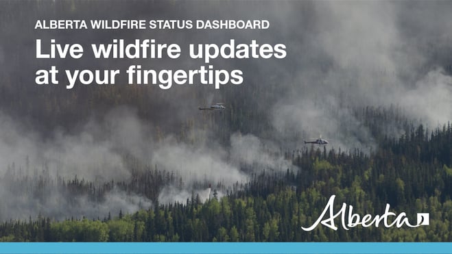
Visit our wildfire dashboard to view active wildfires and their stats.
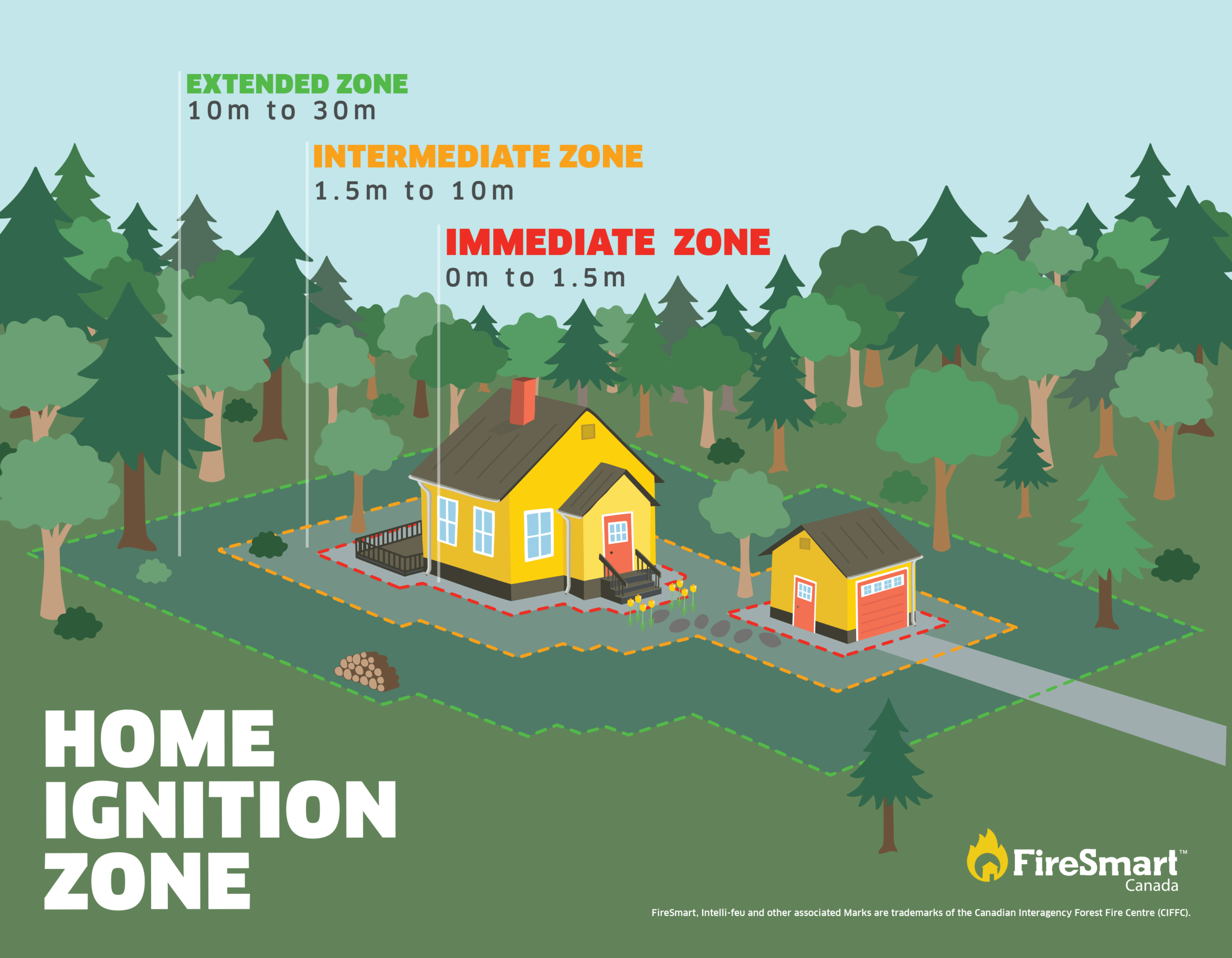
FIRESMART BEGINS AT HOME
Now is as good a time as ever to start thinking about FireSmart, or improving your property to protect it from possible wildfire.
We strongly encourage those with homes, cabins and other structures to FireSmart their properties to limit the impacts of a potential wildfire reaching your door step. To learn more on how you can protect your home and structures from wildfire, visit firesmartcanada.ca or click here to watch videos. FireSmart Canada has also developed a FREE one-hour course for those who are getting started with FireSmart. Click here to learn more.
For those that have farm or acreages, this publication may be helpful to keep you FireSmart. Click on the link for the Farm and Acreage FireSmart Magazine.
You can also check out this handy Last-Minute Wildfire Checklist.
NEW WILDFIRE DETECTIONS
EWF066 was detected today and is currently burning out of control 6 km west-southwest of Edson, on the south side of the McLeod River, west of the Ansell Tower. It's estimated to be 0.5 ha in size and currently burning towards the northwest moving towards the river. There are airtankers acting this wildfire with eight firefighters and two helicopters.
Visit our wildfire dashboard to view active wildfires and their stats (see below for more instructions on wildfire mapping).
PEMBINA WILDFIRE COMPLEX | EWF031, EWF039, RWF034, RWF040
Today on the Pembina Complex, fire behaviour on EWF031 has increased significantly as a result of steady and sustained winds from the southeast, pushing the fire in a northwest direction. Very extreme fire behaviour is being observed, firefighters are observing crown fire, meaning that the wildfire is burning in the tree tops. The wildfire is also producing long-range spotting and independent spot fire which are growing. Firefighting under these conditions is extremely dangerous, we ask that you stay out of these areas and give our firefighters room to work.
Activity along the north and northwest side is extreme and fire has crossed and passed the containment lines. Firefighters, equipment and aircraft have been repositioned to prioritize the fire section that crossed the containment line burning north of Coyote Road approximately 18.5 km from the Town of Edson, as well as the other section of the wildfire east of Rat Creek that crossed the containment line, which is approximately 40 km further east from the Town of Edson.
On the west side of the fire, planned controlled burning operations using aircraft are being utilized to prevent the fire from crossing the Sundance Road. This method is often used under the careful eye of a certified ignition specialist and very successful in removing available fuel that the fire could consume. Bringing the fire to the containment line will prevent the fire from processing further into other stands of trees.
On the east side of the fire, wildfire firefighters have been pulled from areas of high wildfire activity due to the potential for safety reasons and to reposting on areas where ground crews would be more effective. Aerial operations will need to be re-prioritized as some areas have very poor visibility. You may see many of our aircraft at the airport not being used, that's due to them not being able to fly in some of these very smoky conditions.
There are 238 firefighters and support staff being shared between the Pembina Complex. There are 65 pieces of heavy equipment, and 21 helicopters assigned to the complex. An airtanker group is available and will be utilized if visibility in the area improves. In addition, a 20 person Australian crew has arrived at camp and will be to joining operations on the fireline immediately.
EWF031 is burning outside of its containment line due to hot, dry and windy conditions. This video was taken east of Rat Creek and the fire is moving towards the northwest. This is located approximately 20 km west north-west of Cynthia Highway (753) (June 9, 2023 at 2:30 p.m.). **To view this video, open it in the app or the website.
The onsite Incident Management Team is continuing to collaborate with all partners and communities within the vicinity of this wildfire to ensure public safety.
New information on this complex will be available this evening. To view previous Edson Forest Area Updates - Click here.
By: Sarah Hall, Pembina Complex. Wildfire Information Officer, BC Wildfire Service.

DEEP CREEK WILDFIRE COMPLEX | EWF035, WCU001, WCU002
WCU001 was detected on April 29 and remains classified as out of control. The wildfire is estimated to be 6,284 hectares, no new growth has been recorded outside the fire perimeter. The wildfire zone is located southeast of Entwistle and west over the Pembina River where it spread north and travelled over Highway 16. The wildfire is parallel with Highway 16 and moved further west where it spread just north of Wildwood and now rests at Chip Lake.
WCU002 was detected on the evening of April 29 and is a mutual aid wildfire located on both sides of Highway 22, north of Highway 16. The wildfire’s status remains out of control. It is estimated to be 2,478 hectares.
EWF035 was detected on May 5. The northern portion of the fire is located 2 km east of Shining Bank Lake, reaching north and east across Township Road 560 and as far south as approximately 2 km north of the Niton Junction railway. This wildfire is classified as out of control and is estimated to be 19,567 ha. The wildfire is south of Township Road 570, has burnt down to the south and continues to a site two kilometers north of the railroad track in Niton Junction. The fire moved across the Range Road 123 and burnt up to the Lobstick River.
Winds and hot dry weather in the area of the Deep Creek Complex fires have created conditions that are leading to high fire activity on EWF035 this afternoon. Columns of smoke were visible around 1400 near the west flank south of the Township Road 560, and near the east flank, though less prominent. Significant smoke is expected to be seen in the area all afternoon and into the evening. Moderate to high southeasterly winds are pushing smoke and flames towards the northwest. Gusts of around 40 km/h are frequent.
Fire suppression aircraft were on site this morning dropping long term retardant around the areas of the fire that were the most active yesterday. Firefighters are actively working on areas of the fire that are seeing increased activity while helicopters can be seen dropping water where smoke and flames are most prominent. Hot dry weather is expected to continue into tomorrow, and a cold front will be moving into the area Saturday evening. We are expecting a wind shift from southeast to northwest as a result. There is no precipitation in the forecast until late Saturday evening.
As a precautionary measure, Yellowhead County Fire Department with Alberta Wildfire continue to triage residences with regard to the need for structural protection and are continuing to install sprinklers on some residences north of Niton.
Work continues to be done north of Wildwood west of highway 22 to flood heavily peated areas on fires WCU001/002. A high-volume pump is set up at the Cattle Farm on the west side of highway 22, working to flood peat areas. Firefighters are working in conjunction with the high-volume pump using 1.5” hose to nozzle water deep into the peat as they work with handtools, pumps and hose at this location. Firefighters and heavy equipment working near Range Road 91 where they are making good progress.
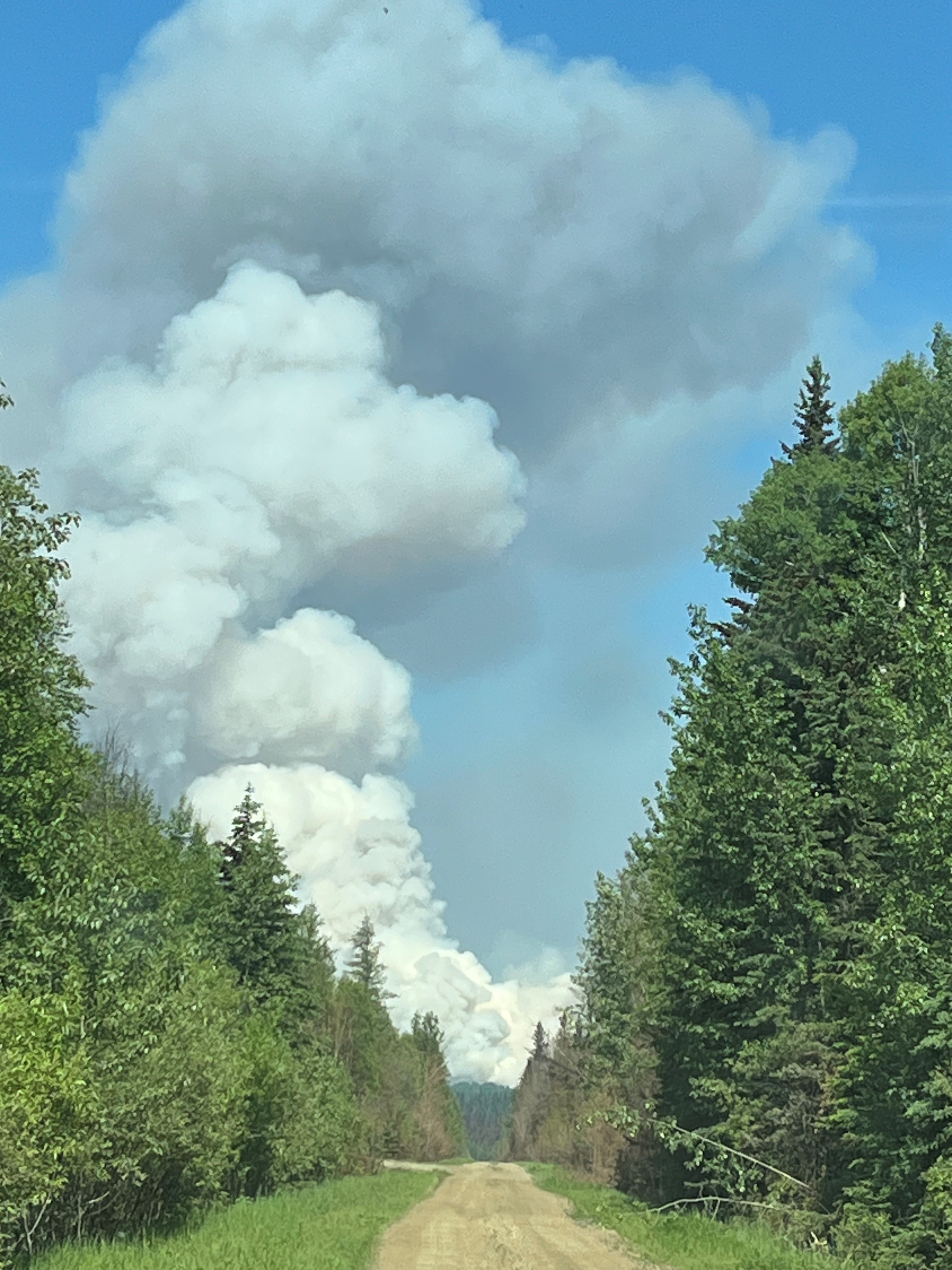 EWF035 is producing a large column of smoke (June 9, 2023)
There are 110 firefighters assigned to the Deep Creek Complex, six helicopters, 40 pieces of heavy equipment and 36 overhead staff that are part of the incident management team and crew supervision. An incident management team from Ontario with members from Alberta is working alongside overhead staff and firefighters from Prince Edward Island, Australia, British Columbia, South Africa and dedicated Alberta Wildfire staff on the Deep Creek Complex.
New information will be available again this evening. Previous Edson Forest Area Updates - Click here.
By: Isabelle Chenard. Wildfire Information Officer, Ontario Ministry of Natural Resources and Forestry. Contact: 780-728-5843.

WILD HAY WILDFIRE COMPLEX | EWF037 and EWF040
The Wild Hay Complex is comprised of two wildfires, EWF037 and EWF040. They are both located south of the Little Smoky River, north of the Wild Hay River and east of Hwy 40 north. The complex is 63 km north of Hinton. EWF040 is producing a lot of smoke that can be seen from far away, including from Hinton.
EWF040 is now out of control and now estimated to be 2,389 ha and growing, it escaped its wildfire boundary on June 7 and is burning mostly to north-northwest from its original area and has crossed the the Berland River and is now burning in both our forest area and the Whitecourt Forest Area.
EWF037 continues to be classified as being held at 578 ha.
GENERAL INFORMATION ON WILDFIRES IN OUR AREA
AREA CHALLENGES | This has been an unprecedented wildfire season; one that has resulted in many challenges for wildfire staff across the province. In response Alberta has been working with our partners to meet the demands for personnel and equipment needed to fight the numerous wildfires we have seen this spring. In the Edson Forest Area we currently have crews and support staff from all over Canada and the world, including U.S.A., Australia, New Zealand and South Africa, B.C., P.E.I., Newfoundland and Ontario.
WORK OR RECREATE NEAR WILDFIRE AREAS | We urge residents and members of the public to use extra caution near burnt areas. There are many hazards that may not be visible, like deep burning ash pits and falling trees. Burnt trees are a serious hazard, and trees that may look healthy that have green needles or leaves could have burnt out roots under the ground and fall unexpectedly. Keep in mind that trees and powerlines could also fall on the road and block your vehicle. Do not approach powerlines as they could be energized.
SMOKE | Lingering smoke can still be visible in some areas and in affected communities. Smoke inversions can trap air near the ground causing dangerous driving conditions and impacting nearby communities. If you have smoke related health concerns, please contact Alberta 811 or visit Alberta Health Services . Visit firesmoke.ca for current and forecasted smoke.
REPORTING WILDFIRES | We always appreciate people calling in to report wildfires but the large volume of calls we are receiving could be diverting our resources away from other essential tasks. As always, call 310-FIRE if you see smoke or flame that looks new and potentially unreported, but assume that large columns of smoke and burned over areas have already been detected and reported. If you or your property are in immediate danger, call 911.
AIRCRAFT NEAR WATER | Depending on the location of a wildfire, firefighting aircraft may need to use water from nearby lakes as a source of water to help fight wildfires. Often, these aircraft arrive without advanced warning. If you are in the water and see an aircraft coming in to collect water, please move within 30 m from the shore so these aircraft can safely resume firefighting efforts. Aircraft are large and require space to collect water, without interference from people and boats. Help us by staying out of the way when aircraft are around. Click here to learn more.
DRONES | The use of recreational drones over wildfires in Alberta is dangerous, illegal and could result in a fine of up to $15,000* for putting aircraft and people at risk. Please give Alberta firefighters the space they need to do their jobs safely. *Transport Canada
WILDFIRE PREPARDNESS | Learn how you can prepare yourself for a wildfire by clicking here.
WILDFIRE INVESTIGATIONS | Wildfires in Alberta are either human-caused or caused by lightning. Every wildfire in Alberta is investigated and the wildfires mentioned remain under investigation.
WILDFIRE CLASSIFICATIONS | To learn more about wildfire classifications, click here.
WILDFIRE MAPS AND BOUNDARIES | Note that wildfire perimeter maps are an estimate based on measurements such as GPS, aerial scanning and satellite imagery. This estimated perimeter can change as more accurate measurements become available. Areas within the fire perimeter may not have been affected by wildfire. Visit our Wildfire Dashboard to view active wildfires and their stats on the wildfire dashboard. Click on "view interactive map". You can choose different basemaps by selecting the four squares icon, or layers by clicking on the three sheets of paper on the top right corner.
**Bold indicates new or important information.

We encourage the public and industry to download the AB Fire Bans app or visit the website to learn more about prohibited and allowed actives under this restriction. If you are looking for information regarding crown land, click on the area you plan to visit and not the nearest town. Be advised that Alberta Parks has it's own set of fire ban levels, please visit their website for more information.
The fire restriction will remain in effect until conditions improve. To view the Alberta Wildfire Fire Ban video, click here.
Albertans are always asked to use caution when working or recreating in the outdoors:
- Before you burn it, get your fire permit. Fire permits in Alberta.
- Clear debris from hot spots on your off-highway vehicle.
- Ensure your campfire is out - soak it, stir it, soak it again.
- Before you head out this weekend, check out the albertafirebans.ca website or download the app to stay informed.
- For road closure information, please visit 511.alberta.ca
- For information regarding smoke in the area, you can visit firesmoke.ca
- NASA FIRMS Fire Information website is a great resource to give an idea of the location of wildfires in the area, but note that the data is based on interpolation and often can make the wildfire look larger then it actually is.
ALBERTA WILDFIRE INFORMATION
- Subscribe to the Edson Forest Area wildfire update to receive an email when new information is posted.
- Download the Alberta Wildfire App for Apple and Android device.
- Join the conversation on Facebook, Twitter or Instagram.
For more information, please contact: