
Please do not report smoke or flame from within an active wildfire area. Firefighters are being diverted from essential tasks when responding to existing fires reported by the public. You may see smoke or flame within the existing boundary of a wildfire, this is normal.
If you see smoke or flame outside of an active fire area, report it to 310-FIRE. If you or your property is in immediate danger, call 911.
Previous Edson Forest Area Updates - Click here
NEW WILDFIRE DETECTIONS
There are currently no new wildfires detected.
Initial attack crews are put on standby to action any new wildfire starts, especially when the fire danger increases. The wildfire firefighters were busy yesterday evening, actioning three new wildfires which are now extinguished. They are often assisted by helicopters with buckets to extinguish them quickly.
In the past few days, the area has actioned five new wildfires which burnt a total of 1.04 ha. The wildfires were determined to be caused by lightning.
Visit our Wildfire Dashboard to view active wildfires and their stats on the wildfire dashboard.
GENERAL INFORMATION ON WILDFIRES IN OUR AREA
AREA CHALLENGES | This has been an unprecedented wildfire season; one that has resulted in many challenges for wildfire staff across the province. In response Alberta has been working with our partners to meet the demands for personnel and equipment needed to fight the numerous wildfires we have seen this spring. In the Edson Forest Area we currently have crews and support staff from all over Canada and the world, including U.S.A., Australia, New Zealand and South Africa, B.C., P.E.I., Newfoundland and Ontario.
WORK OR RECREATE NEAR WILDFIRE AREAS | We urge residents and members of the public to use extra caution near burnt areas. There are many hazards that may not be visible, like deep burning ash pits and falling trees. Burnt trees are a serious hazard, and trees that may look healthy that have green needles or leaves could have burnt out roots under the ground and fall unexpectedly. Keep in mind that trees and powerlines could also fall on the road and block your vehicle. Do not approach powerlines as they could be energized.
SMOKE | Lingering smoke can still be visible in some areas and in affected communities. Smoke inversions can trap air near the ground causing dangerous driving conditions and impacting nearby communities. If you have smoke related health concerns, please contact Alberta 811 or visit Alberta Health Services . Visit firesmoke.ca for current and forecasted smoke.
REPORTING WILDFIRES | We always appreciate people calling in to report wildfires but the large volume of calls we are receiving could be diverting our resources away from other essential tasks. As always, call 310-FIRE if you see smoke or flame that looks new and potentially unreported, but assume that large columns of smoke and burned over areas have already been detected and reported. If you or your property are in immediate danger, call 911.
AIRCRAFT NEAR WATER | Depending on the location of a wildfire, firefighting aircraft may need to use water from nearby lakes as a source of water to help fight wildfires. Often, these aircraft arrive without advanced warning. If you are in the water and see an aircraft coming in to collect water, please move within 30 m from the shore so these aircraft can safely resume firefighting efforts. Aircraft are large and require space to collect water, without interference from people and boats. Help us by staying out of the way when aircraft are around. Click here to learn more.
DRONES | The use of recreational drones over wildfires in Alberta is dangerous, illegal and could result in a fine of up to $15,000* for putting aircraft and people at risk. Please give Alberta firefighters the space they need to do their jobs safely. *Transport Canada
WILDFIRE PREPARDNESS | Learn how you can prepare yourself for a wildfire by clicking here.
WILDFIRE INVESTIGATIONS | Wildfires in Alberta are either human-caused or caused by lightning. Every wildfire in Alberta is investigated and the wildfires mentioned remain under investigation.
WILDFIRE CLASSIFICATIONS | To learn more about wildfire classifications, click here.
WILDFIRE MAPS AND BOUNDARIES | Note that wildfire perimeter maps are an estimate based on measurements such as GPS, aerial scanning and satellite imagery. This estimated perimeter can change as more accurate measurements become available. Areas within the fire perimeter may not have been affected by wildfire. Visit our Wildfire Dashboard to view active wildfires and their stats on the wildfire dashboard. Click on "view interactive map". You can choose different basemaps by selecting the four squares icon, or layers by clicking on the three sheets of paper on the top right corner.
**Bold indicates new or important information.
PEMBINA WILDFIRE COMPLEX | EWF031, EWF039, RWF034, RWF040
Today, there are 89 firefighters and IMT support staff being shared between all fires on the Complex. A BC Wildfire Service IMT has assumed command of the complex after a transitioning with the outgoing American IMT. There are 113 pieces of heavy equipment, and 21 helicopters assigned to the complex. An airtanker group is available to respond if necessary. 140 South African crew members arrived today. They were situationally briefed and will be joining the fireline efforts tomorrow. They will be performing gridding patrols and utilizing direct attack for hotspots in the area.
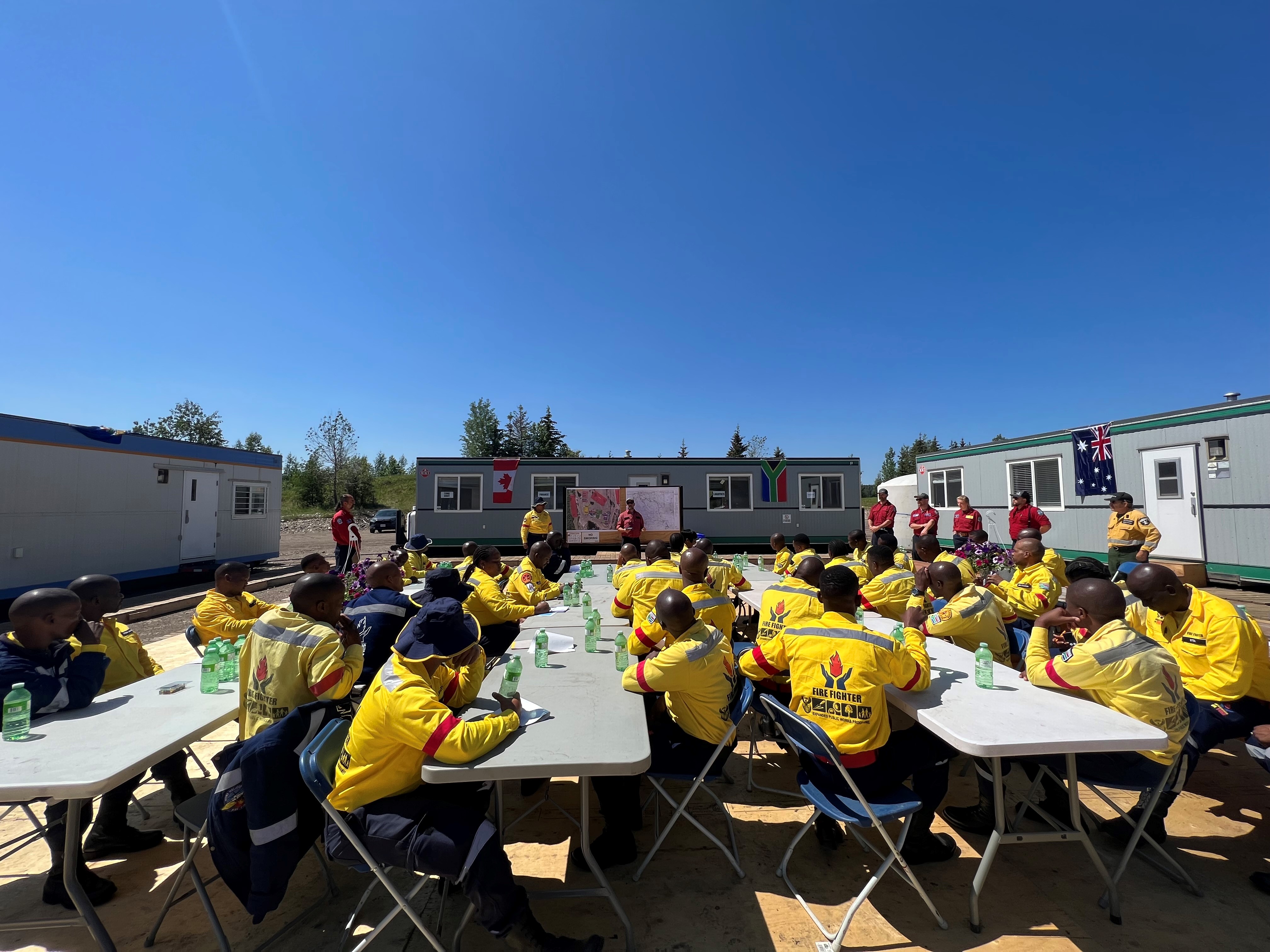
(Today, June 6th, the South African Contingency arrived to fire camp. They will be present on the fireline tomorrow.)
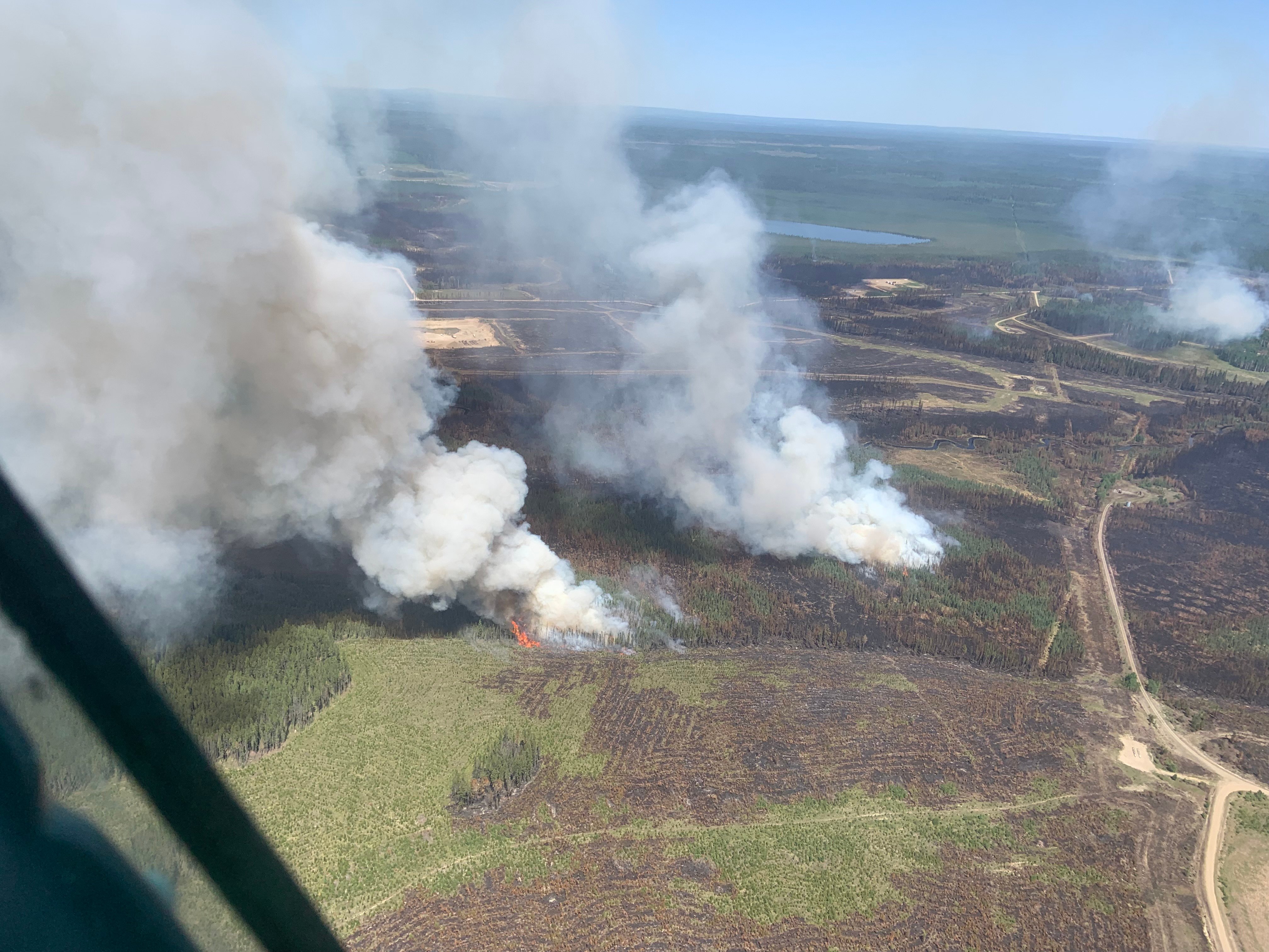
Today at the Pembina Complex, both fire EWF031 and EWF034 are exhibiting increased fire behaviour within the fire perimeter as a result of a current warming and dying trend. When these fires were initially detected, they were extremely aggressive and primarily wind driven. Due to the significant speed the fires traveled a month ago, the fires burnt in mosaic like patterns, causing a patchwork of burned areas with pockets of unburnt fuels within. Unburnt fuel within the fire perimeter can still ignite and will display smoke columns in the area and to nearby communities and commuters on adjacent highways. Resources assigned to the fire are repositioning to areas of increased activity as required with aviation support.
EWF031 was detected on May 4 and is located 25 km west of Lodgepole, 20 km northwest of Brazeau Dam and 14 km southeast of Edson. The fire is classified as out of control and is estimated to be 130,762 ha in size.
(Activity located on fire 31 on the eastern flank, west of rat creek today, June 6.)
Today, personnel were out assessing proposed secondary containment line along the western side of the fire to determine the positioning of staff. This operation commenced today, and the containment line will take approximately three to five days to construct from the northwest side of fire 31 to the southwest side of fire 40. The majority of the containment line will be pre-existing roads.
Crews and heavy equipment have successfully placed containment line around the entire excursion located on the northeast portion of the fire, just west of Rat Creek. Increased activity is continuing to be observed within the perimeter on the eastern flank of the fire, just west of Rat Creek. Aerial support was repositioned today to support this area of the fire. Large columns of smoke were visible today and will continue to be visible over the coming days as pockets of green fuel within the fire perimeter ignite due to the warming and drying conditions.
An Infrared scan was completed again last night, and crews are utilizing direct attack on identified hotspots along the perimeter of the east flank, with aviation support when necessary. Scanning missions will continue every night in order to identify hotspots within the fire perimeter over the coming days. Personnel will continue to monitor and patrol the fire perimeter utilizing the infrared scan results.
EWF039 located near Carrot Creek, is currently being held. The fire is currently estimated to be 165 ha. The fire is fully wrapped in containment line and is a kilometer away from the Carrot Creek lookout tower. The Lookout staff will keep watch over the area.
RWF034 is located near the O'Chiese Reserve and classified as out of control. The fire is currently estimated at 87,108 ha in size.
On the south side of RWF034 along the Brazeau River, dozer guard construction was completed on Sunday. Crews are supporting the guard and monitoring conditions working south along the west flank.
Today, personnel were out assessing proposed secondary containment line along the western side of the fire to determine the positioning of staff. This operation commenced today, and the containment line will take approximately three to five days to construct from the west side of fire 40 to the northwest of fire 31. The majority of the containment line will be pre-existing roads.
An Infrared scan was completed again last night, and crews are utilizing direct attack on identified hotspots along the perimeter of the east flank, with aviation support when necessary. Scanning missions will continue every night in order to identify hotspots within the fire perimeter over the coming days. Personnel will continue to monitor and patrol the fire perimeter utilizing the infrared scan results.
RWF040 The fire is actively monitored by firefighters and support staff assigned to the complex who can respond if necessary. The fire is currently estimated to be 5,089 ha in size and remains classified as out of control. Containment line was completed a couple of days ago around the east, south, and west sides of the fire. Crews will continue working from the Blackstone River clockwise around the fire perimeter. Crews are actively supporting the guard with the installation of water systems which includes hose and pumps.
By: Sarah Hall, Pembina Complex. Wildfire Information Officer, BC Wildfire Service.

DEEP CREEK WILDFIRE COMPLEX | EWF035, WCU001, WCU002
WCU001 was detected on April 29 and remains classified as out of control. The wildfire is estimated to be 6284 hectares, no new growth has been recorded outside the fire perimeter. The wildfire zone is located southeast of Entwistle and west over the Pembina River where it spread north and travelled over Highway 16. The wildfire is parallel with Highway 16 and moved further west where it spread just north of Wildwood and now rests at Chip Lake.
WCU002 was detected on the evening of April 29 and is a mutual aid wildfire located on both sides of Highway 22, north of Highway 16. The wildfire’s status remains out of control. It is estimated to be 2478 hectares.
Despite a cool morning in the area, temperatures rose to the low twenties today with sunny skies over the Deep Creek Complex. A warming trend is forecasted for this week with temperatures expected to reach the high twenties by Friday. No precipitation is in the forecast and fire behavior is expected to increase as the week goes on within the interior of the fire.
There has been no new growth outside of the fire perimeter of either of these wildfires and observed fire behavior continues to be relatively low with some areas generating smoke today. Firefighters continue to make good progress on containing the wildfire and "mopping up", meaning that they are putting out hotspots.
Work continues to be done north of Wildwood west of highway 22 to flood heavily peated areas. Helicopters are bucketing onto hot spots as needed. A high-volume pump has completed work in one area on the west side of highway 22 alongside heavy equipment and has moved to another location to the south along the same road, fire crews are working alongside it and working with hand tools and hose in the peat.
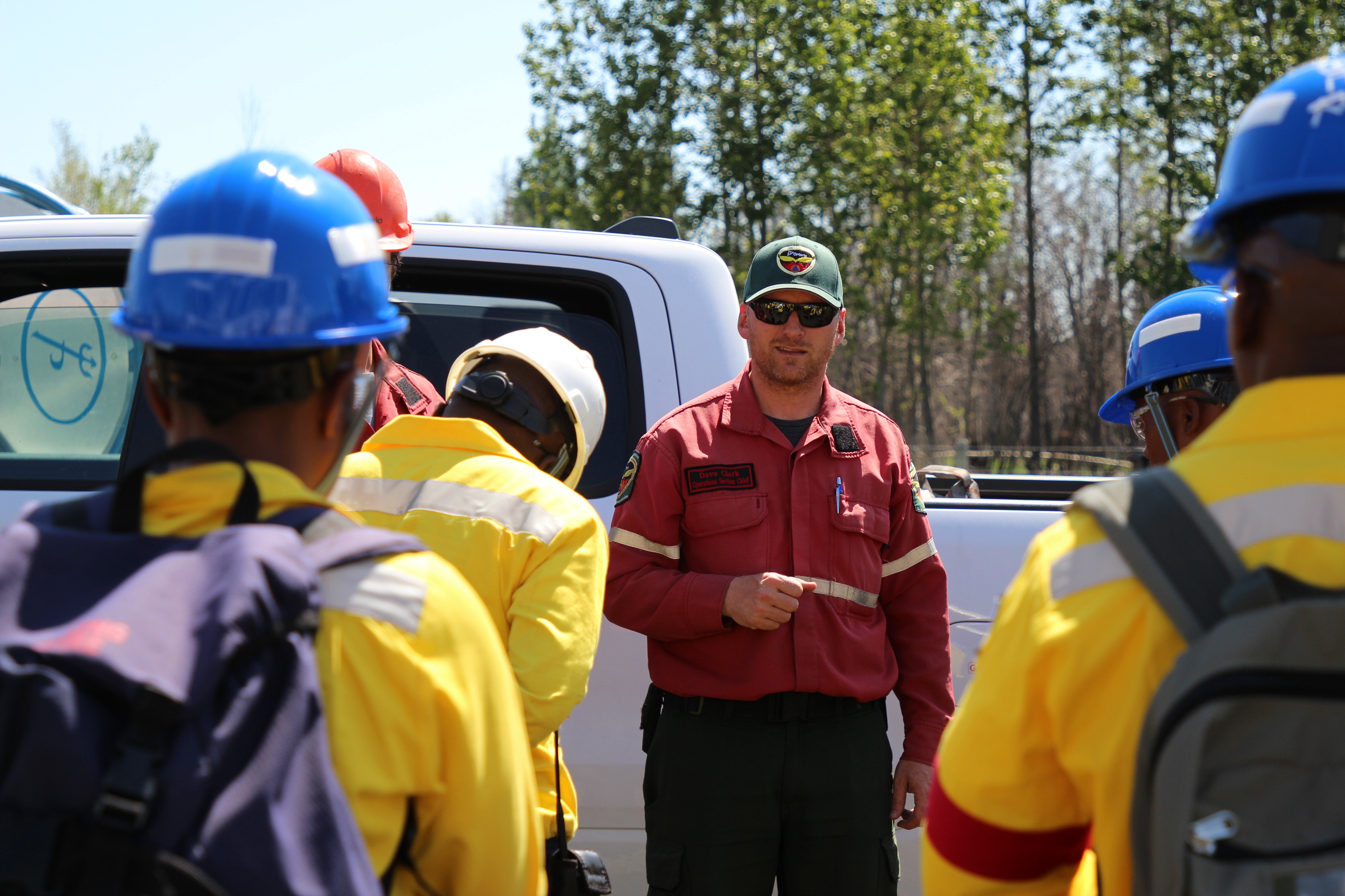
(Operations Chief Dave Clark from Ontario briefs the incoming South African firefighters on fire WCU002 this afternoon, June 6)
Smoke may continue to be seen as flare-ups occur on the interior. This is expected to persist in the peat areas where the fire is burning deep, smouldering under the layers of peat and burning roots and other organic matter.
A reclamation has begun to assess areas of these fire that can be actioned.
Deep ash pits and burning peat are dangerous. We ask residents to be extra cautious near burnt areas.
We also ask residents to avoid venturing into forested areas that have been recently affected by wildfire as they can present other hazards such as falling trees, as a result of root systems being compromised by fire.
EWF035 was detected on May 5. The northern portion of the fire is located 2 km east of Shining Bank Lake, reaching north and east across Township Road 560 and as far south as approximately 2 km north of the Niton Junction railway.
This wildfire is classified as out of control and is estimated to be 19,567 ha. The wildfire is south of township Road 570, has burnt down to the south and continues to a site two kilometers north of the railroad track in Niton Junction. The fire moved across the Range Road 123 and burnt up to the Lobstick River.
Hot and windy conditions did increase fire activity in a few spots within the interior of the fire today, this is expected to continue throughout the week as temperatures rise and the relative humidity drops.
Wildland firefighters continue to work with heavy equipment to contain the wildfire on the south and north sections of the fire (the latter closer to Township Road 560 in the interior).
Some of the hotshot crews from the U.S. continued to work on the east-south-east side of the fire where hotspots were prevalent today. They will be returning home tomorrow and we thank them for their hard work at the Deep Creek Complex. Firefighters continue to work on the southwest side of this fire, continuing to establish containment line along the perimeter. British Columbia crews are working on the southern portion of the interior of the fire, south of Township Road 560 and on the northeastern-most side of the fire. Heavy equipment and firefighters are working in the central portion of he fire south of Township Road 560.
The perimeter from the northeast of the fire towards the northwest was cool again today with little to no fire activity. Firefighters are confident that the whole north and west boundary of the wildfire, down East Bank Road (Range Road 133A) is now contained and expect that the containment line wouldn't be challenged if the winds pushed the wildfire towards that direction again.
A reclamation specialist continues to assess areas of the fire that can be actioned.
Fire behaviour typically increases during the peak burning period. This is normally mid-afternoon, when temperatures are hottest and relative humidity drops. Fire activity tends to slow down in the morning and late evenings when temperatures are cooler and humidity levels are higher.
Wednesday’s forecast shows temperatures in the mid twenties with relative humidity values in the 25% range. Easterly winds are expected to be light at 10 km/h and generally easterly for the next few days. With no precipitation in the forecast and a continuous drying trend, the fire behavior is expected to increase within the interior of the fire this week. Smoke in within the perimeter of the fire is normal.
There are 79 firefighters assigned to the Deep Creek Complex, six helicopters, 39 pieces of heavy equipment and 35 overhead staff that are part of the incident management team and crew supervision. An incident management team from Ontario with members from Alberta is working alongside overhead staff and firefighters from Prince Edward Island, Australia, British Columbia, the United States and dedicated Alberta Wildfire staff on the Deep Creek Complex. 65 South African firefighters have arrived today and joined the fire crews on the fire line this afternoon. Additional resources are expected to arrive in the coming days.
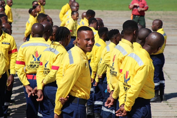
(65 South African firefighters arrived at the Deep Creek Complex today to help with fire suppression efforts.)
By: Isabelle Chenard. Wildfire Information Officer, Ontario Ministry of Natural Resources and Forestry. Contact: 780-728-5843.

WILD HAY WILDFIRE COMPLEX | EWF037 and EWF040
EWF037 continues to be classified as being held at 578 ha and EWF040 is being held at 684 ha. These wildfires are located south of the Little Smoky River, north of the Wild Hay River and east of Hwy 40 north.

We encourage the public and industry to download the AB Fire Bans app or visit the website to learn more about prohibited and allowed actives under this restriction. If you are looking for information regarding crown land, click on the area you plan to visit and not the nearest town. Be advised that Alberta Parks has it's own set of fire ban levels, please visit their website for more information.
The fire restriction will remain in effect until conditions improve. To view the Alberta Wildfire Fire Ban video, click here.
Albertans are always asked to use caution when working or recreating in the outdoors:
- Before you burn it, get your fire permit. Fire permits in Alberta.
- Clear debris from hot spots on your off-highway vehicle.
- Ensure your campfire is out - soak it, stir it, soak it again.
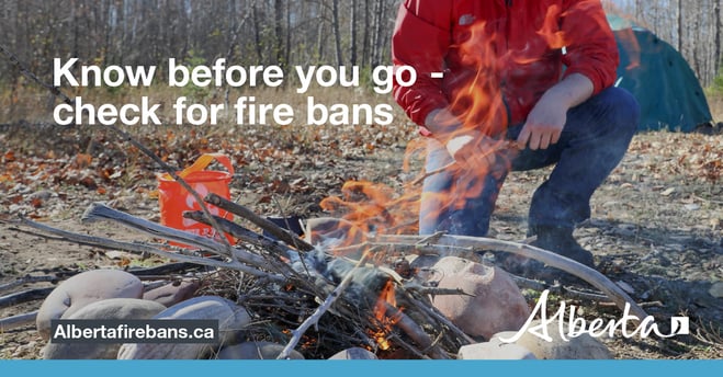
- Before you head out this weekend, check out the albertafirebans.ca website or download the app to stay informed.
- For road closure information, please visit 511.alberta.ca
- For information regarding smoke in the area, you can visit firesmoke.ca
- NASA FIRMS Fire Information website is a great resource to give an idea of the location of wildfires in the area, but note that the data is based on interpolation and often can make the wildfire look larger then it actually is.
ALBERTA WILDFIRE INFORMATION
- Subscribe to the Edson Forest Area wildfire update to receive an email when new information is posted.
- Download the Alberta Wildfire App for Apple and Android device.
- Join the conversation on Facebook, Twitter or Instagram.
For more information, please contact: