
Residents near wildfire RWF040 near the Brazeau River may see columns of smoke due to a controlled burn starting near noon. See information below.
Please do not report smoke or flame from within an active wildfire area. Firefighters are being diverted from essential tasks when responding to existing fires reported by the public. You may see smoke or flame within the existing boundary of a wildfire, this is normal.
If you see smoke or flame outside of an active fire area, report it to 310-FIRE. If you or your property is in immediate danger, call 911.
Previous Edson Forest Area Updates - Click here
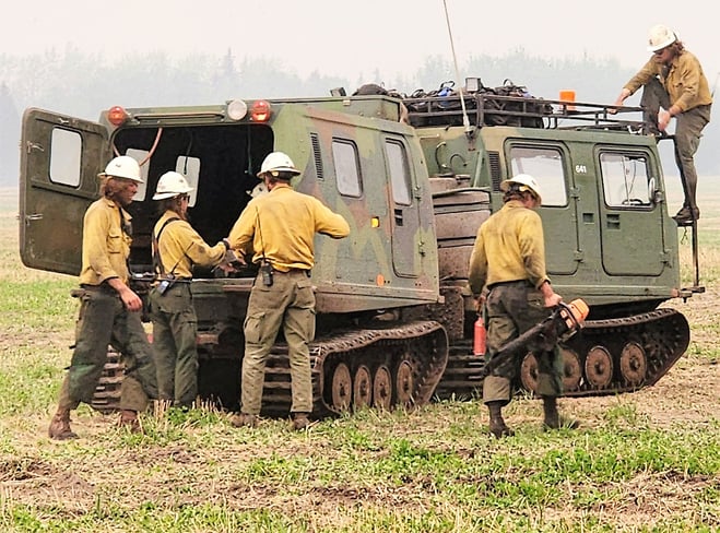
Firefighters benefit from specialized equipment like Nodwells. They can be used to carry firefighters and their equipment over challenging terrain. (May 26, 2023)
After thorough planning, AB Wildfire and U.S. firefighters are considering the use of a controlled burn operation. This will only occur if all weather, wind and other requirements are met. The methods used can include aerial ignition using helicopters between the southern edge of the EWF040 fire and the Brazeau River.
This activity may possibly begin today May 26, 2023 sometime this afternoon and continuing over the next several days as conditions permit safe and controlled burning operations. All safety precautions will be in place prior to start.
The goal of this operation is to remove the available fuel between the fire’s edge and the containment line. This strategy slows down and helps limit the spread of the wildfire by decreasing the amount of fire perimeter that must be managed by firefighters.
Firefighters will closely monitor and evaluate the situation as conditions change. In preparation for these operations, fire suppression equipment and firefighters will be in position to extinguish any flame that may be near the containment line.
Note that increased smoke from this wildfire will be visible from surrounding communities.


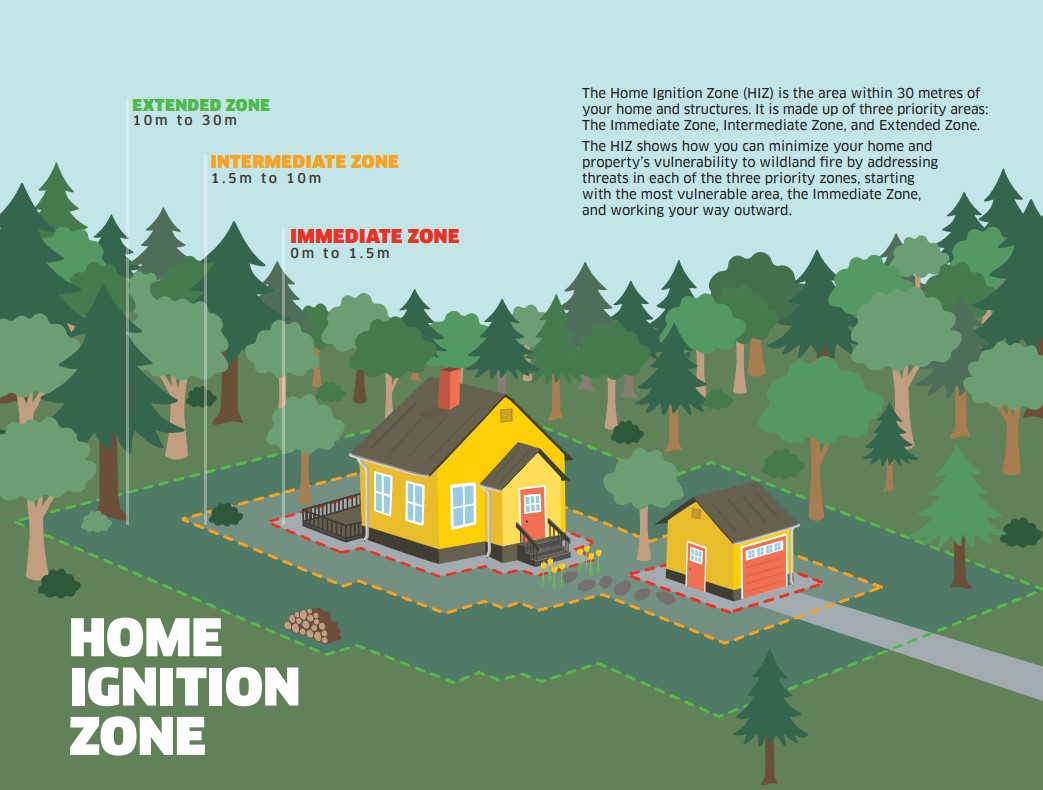
FIRESMART BEGINS AT HOME
Protecting your home starts with simple actions.
There are many factors that may impact your property's risk to wildfire. Check out the FireSmart Begins at Home Guide for an in-depth look at how you can build wildfire resiliency.
Click here to view the FireSmart Begins at Home booklet. You can also request a copy from the Edson Forestry Office!
GENERAL INFORMATION ON WILDFIRES IN OUR AREA
**Bold indicates new or important information.
The area continues to have limited resources due to these exceptional times. We're sharing valuable resources with many other wildfires in the province but continue to work on and monitor the following wildfires in our area: WCU001, WCU002, EWF035, EWF031, EWF039, EWF037, EWF040 and new starts that are detected.
Firefighters, aircraft, and heavy equipment have been working in conjunction with county and municipal firefighting services as aggressively as possible to make progress on these wildfires while the conditions have been favorable. Despite all of this hard work, there are still hundreds of kilometers of uncontained wildfire perimeter and fire behaviour forecasts indicate that there may be growth on some of the wildfires throughout the Edson Forest Area.
Lingering smoke can still be visible in some areas and in affected communities. Smoke inversions can trap air near the ground causing dangerous driving conditions and impacting nearby communities. Please use EXTRA CAUTION WHEN DRIVING IN SMOKY CONDITIONS!
While we always appreciate people calling in to report wildfires, the large volume of calls we are currently receiving is diverting our resources away from other essential tasks. As always, please still call 310-FIRE if you see smoke or flame that looks new and potentially unreported, but assume that large columns of smoke and burned over areas have already been detected and reported.
All wildfires in Alberta are investigated and these wildfires remain under investigation. To learn more about wildfire classifications, click here.
ACTIVE WILDFIRES
PEMBINA WILDFIRE COMPLEX - EWF031/039, RWF034/040
(NO NEW UPDATE UNTIL THIS EVENING)
Today, there were 118 firefighters and IMT support staff being shared between all fires on the Complex. There were 60 pieces of heavy equipment, and 13 helicopters assigned to the complex. An airtanker group was still available to respond if necessary.
Aircraft were been busy today doing reconnaissance on the fire. Two helicopters will arrive this evening and a third one in the next day or so, to support current and future suppression efforts.
Roads in the area are drying and firming up allowing better access to critical areas of the fire. Today all the crews made it out to the line and are engaged. They are working direct on the fire line using tools and water hoses to mop up, secure, and fill in some of the gaps between the fire and the dozer lines. They continue to link containment line and secure the north end of the fire.
Fire behavior today – Minimal areas of smoldering and creeping fire. Some morning rain showers were passing over the west half of the fire. Tomorrow there will be slightly reduced relative humidity resulting slowly drying fuels. The trend is for slow warming and drying through Saturday.
EWF031 was detected on May 4 and is located 25 km west of Lodgepole, 20 km northwest of Brazeau Dam and 14 km southeast of Edson. The fire is classified as out of control and is estimated to be 124,051 ha in size. Increased size is attributed to growth that has been observed over the last couple of days and due to more accurate mapping.
There is a containment line on the north side of the fire working downwards towards 6 Mile Road as well as a containment line located south from Dora’s Corner (completed several days ago). Both lines will have continued air support as visibility allows, and it is safe for aviation resources to operate to perform bucketing.
EWF039 located near Carrot Creek, is currently being held. The fire is currently estimated to be 165 ha. The fire is fully wrapped in containment line and is a kilometer away from the Carrot Creek lookout tower. Crews successfully left the area and have been repositioned on fire EWF031. Personnel are continuing to monitor the area available to respond if necessary.
RWF034 is located near the O'Chiese Reserve and classified as out of control. The fire is currently estimated at 87,108 ha in size. The increased size is attributed to growth that has been observed over the last couple of days and due to more accurate mapping.
Effective May 23, 2023 around 16:00hrs, the evacuation order for the O’Chiese FN was lifted and there are no alerts in place.
RWF034 and RWF040 have connected and will be managed as one fire although they will be tracked individually for the time being.
RWF040 The fire is being monitored by firefighters and support staff assigned to the complex and are able to respond if necessary. The fire is currently estimated to be 5,089 ha in size. The increased size is attributed to growth that has been observed over the last couple of days and due to more accurate mapping. Growth has occurred mostly to the west. The Blackstone Lookout Tower in the area is currently not at risk.
By: Kent Romney, Pembina Complex.
If you have any questions or concerns about the PEMBINA COMPLEX please call the Area Wildfire Information Officer: Caroline Charbonneau at 780-740-1341
DEEP CREEK WILDFIRE COMPLEX – EWF035, WCU001 & WCU002
(NO NEW UPDATE UNTIL THIS EVENING)
DEEP CREEK WILDFIRE COMPLEX – EWF035, WCU001 & WCU002
WCU001 was detected on April 29 and is classified as out of control. The wildfire remains at 7,281 ha in size, no new growth was recorded outside the fire perimeter. The wildfire zone is located southeast of Entwistle and west over the Pembina River where it spread north and travelled over Highway 16. The wildfire is parallel with Highway 16 and moved further west where the wildfire spread just north of Wildwood and now rests at Chip Lake.
WCU002 was detected on the evening of April 29 and is a mutual aid wildfire located on both sides of Highway 22, north of Highway 16. The wildfire is currently burning out of control. The wildfire is estimated to be 2,400 ha in size.
There was no new growth outside on either of these wildfires and very little fire activity was observed.
Please be advised there are 50km/hr construction signs set up on highway 22 North due to heavy equipment and wildland firefighters working along the roadside.
Patches of unburned vegetation may continue to burn inside the perimeter. Firefighters will often use an indirect attack approach to these challenging wildfires, letting them burn up to a natural break such as a road or a river. This ensures that the remaining vegetation within doesn’t continue to burn later in the season. Residents may see smoldering and flare ups at times within the perimeter. This is a normal occurrence until firefighters contain the fire perimeter to ensure it doesn’t grow, then work their way from the outside edge inwards. Firefighters will need to search for these hotspots, sometimes digging into the ground with their hands and feeling for heat. They use hand tools to dig the spots out and water to extinguish them. Simply putting water on a fire does not extinguish it. This process can take a long time and residents can expect that the fire will remain "out of control" until firefighters are confident that the fire is contained. At that time, the status will be changed to "being held" while they work towards extinguishment.
Deep ash pits and burning peat are dangerous. We ask residents to be extra cautious when near burnt areas.
EWF035 was detected on May 5 and is located 3 km east of Shining Bank. This wildfire is classified as out of control and estimated to be 20,996 ha in size. The wildfire is south of Township Road 570, burnt down to the south, two kilometers north of the railroad track in Niton Junction. The fire moved across the Range Rd 123 and burnt up to the Lobstick River.
Firefighters did not observe very much fire activity again today, due to the higher relative humidity and cooler temperatures. More precipitation will be required to significantly improve the dry conditions.
Wildland firefighters continue to work with heavy equipment to contain the wildfire on the south sections of the fire. They also worked on hot areas near the southwest, southeast, and east sections and plan to return tomorrow. A completed containment line made up of dozer guard and natural breaks along the south and east sections of the fire is established. Helicopters assisted on the fire today.
The complex has 67 wildland firefighters, four helicopters, 20 pieces of heavy equipment and 25 overhead staff that are part of the incident management team. These personnel consist of heavy equipment coordinators, aircraft supervisors, task force leaders who work with the crews in the field, information officers who share information with the public and other key stakeholders such as industry. It also consists of logistics, facilities and equipment managers who ensure that firefighters are fed, lodged, and have hot showers and tools to do their job safely. A large team like this also requires a finance team to ensure they track costs and payments. The camp is also prepared to receive many more firefighters in the coming weeks and can support up to 153 personnel. There are three other similar camps supporting the two complexes in our forest area.
By: Tara Stephens.
If you have any questions or concerns about the DEEP CREEK COMPLEX please call the Wildfire Information Officer - Caroline Charbonneau at 780-740-1341
WILD HAY WILDFIRE COMPLEX - EWF037 and EWF040
There are multiple wildfires located south of the Little Smoky River, north of the Wild Hay River and east of Hwy 40 north. These also include the areas near the Willow Haul Road and the Jack Wright Road north of Hinton. These wildfires were formerly reported as five separate fires, but due to more accurate GPS measuring, have been determined to be two larger fires.
EWF037 is being held at 578 ha and EWF040 is being held at 684 ha.
There has been no perimeter growth on this complex is several days. Smoke and flame may still be observed within the interior of both EWF037 and EWF040.
This complex is now being patrolled and monitored.
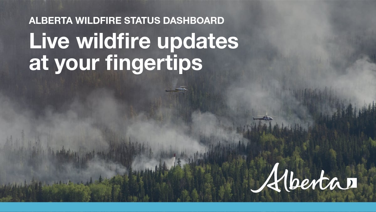
PUBLIC WILDFIRE MAPS
Visit our Wildfire Dashboard to view active wildfires and their stats on the wildfire dashboard.
Deep Creek Wildfire Complex (EWF035, WCU002 and WCU001) May 25, 2023 - public map - Click here.
Pembina Wildfire Complex (EWF031, EWF039, RWF034, RWF040) May 23 , 2023 - public map - Click here. *this map does not show other wildfire nearby.
Edson Forest Area Fires May 23, 2023 - public map - Click here.
Note: The wildfire perimeter map is an estimate based on measurements such as GPS, aerial scanning and satellite imagery. This estimated perimeter can change as more accurate measurements become available. Areas within the fire perimeter may not have been affected by wildfire.
WILDFIRE LINKS AND TOOLS
There are multiple EVACUATION ORDERS & ALERTS in the Province. Please visit Alberta Emergency Alerts or your community webpage for more information.
For road closure information, please visit: 511.alberta.ca
The NASA FIRMS Fire Information website is a great resource to give an idea of the location of wildfires in the area, but it should be noted that this data is based on interpolation and often can make a wildfire appear larger than it actually is.
Wildfire smoke is a tool used for the location of smoke firesmoke.ca
DO NOT FLY DRONES NEAR WILDFIRES!
The use of recreational drones over wildfires in Alberta is dangerous, illegal and could result in a fine of up to $15,000* for putting aircraft and people at risk. Please give Alberta firefighters the space they need to do their jobs safely. *Transport Canada
COMMUNITY EMERGENCY INFORMATION | EVACUATIONS
A MESSAGE FROM THE MUNICIPALITIES
If you are evacuating, gather important documents, medication, and enough food and water to be away from home for at least 3 days. Take pets with you.
For updates from Yellowhead County and Town of Edson, please visit their Facebook page: https://www.facebook.com/yellowheadcounty or www.yhcounty.ca for updates. Evacuees can call 1-833-334-4630 for more information.
For updates from Parkland County, please visit their Facebook page: https://www.facebook.com/ParklandCountyAB. Residents in the affected areas can contact the Emergency Information Line at 1-780-968-8888.
For residents with health concerns related to smoke you can find the air quality map here: https://www.alberta.ca/about-the-air-quality-health-index.aspx. If you have smoke related health concerns, please contact AB 811 and click here for more information.
Albertans are always asked to use caution when working or recreating in the outdoors:
- Before you burn it, get your fire permit. Fire permits in Alberta.
- Clear debris from hot spots on your off-highway vehicle.
- Ensure your campfire is out - soak it, stir it, soak it again.
- Before you head out this weekend, check out the albertafirebans.ca website or download the app to stay informed.
ALBERTA WILDFIRE INFORMATION
- Subscribe to the Edson Forest Area wildfire update to receive an email when new information is posted.
- Download the Alberta Wildfire App for Apple and Android device.
- Join the conversation on Facebook, Twitter or Instagram.
For more information, please contact: