
A DRONE IN THE SKY MEANS WE CAN'T FLY!
NEW Location | Information Stations | Deep Creek Complex | May 19 & 20
Due to the current dry grass, warm weather and possible windy conditions, there is an increased risk of wildfires in the Edson Forest Area. We urge residents and visitors to exercise extra caution when working and recreating.
Previous Edson Forest Area Updates - Click here
DEEP CREEK COMPLEX INFORMATION STATION
Tara will be hosting an information station tomorrow, look for the orange wildfire tent at the following locations:
SATURDAY & SUNDAY MAY 20/21, 2023
Peers Fire Hall | 11:00 a.m. - 1:00 p.m.
Wildwood Fire Hall (across street) | 2:00 p.m. - 4:00 p.m.
Niton Junction Gas Stations (Hwy 16) | 5:00 p.m. - 7:00 p.m.
DEEP CREEK WILDFIRE COMPLEX – EWF035 SPECIAL EDITION
An incident management team from the U.S Forest Service along with many of their firefighters have arrived on May 14 to assist our area with one of the three wildfire complexes in the area. We want to thank our American friends for coming to assist us. A special arrangement has been in place for many years between Canada, the U.S, Australia and other countries that have similar firefighting training standards. We take safety and training very seriously and always seek to improve our operations.
EWF035 was detected on May 5 and is located 3 km east of Shining Bank. This wildfire is classified as out of control and estimated to be 8,791 ha in size. The wildfire is south of Township Road 570, west of Range Road 123, north the fire is now south of Twp 560, it has spotted a few places over East Bank Road but is not active at this time. The fire remains east of Shining Bank Lake.
There was new growth on the fire yesterday which burnt towards the west, but the fire was very spotty, not burning in a continuous pattern through the forest. The fire spotted in multiple places, burning mostly in spruce stands. The fire spotted over East Bank road in a few places, but firefighters were able to work on these spots and reduce the fire behaviour.
SOUTHEAST OF EWF035
The winds have shifted earlier then expected today and the fire started to move towards the east on the southeastern boundary of the fire. The fire is burning very intensely in spruce stands but there are waterbodies in the area, which will hopefully slow the fire down.
The latest report was that the fire had reached the community of Hattenford, near Range Rd 123, south of Twp Rd 555 and moving towards the south-southeast. Firefighters hope that the fire will decrease in fire activity when it reaches treeless areas, as the grass has greened up and should be more difficult for the fire to continue.
The video below was from 11:00 a.m. this morning when the fire was picking up activity in the spruce stands.
EWF035 - Fire actively moving towards the south-southeast on the east side of EWF-035 (11:00 a.m.) (May 19, 2023).
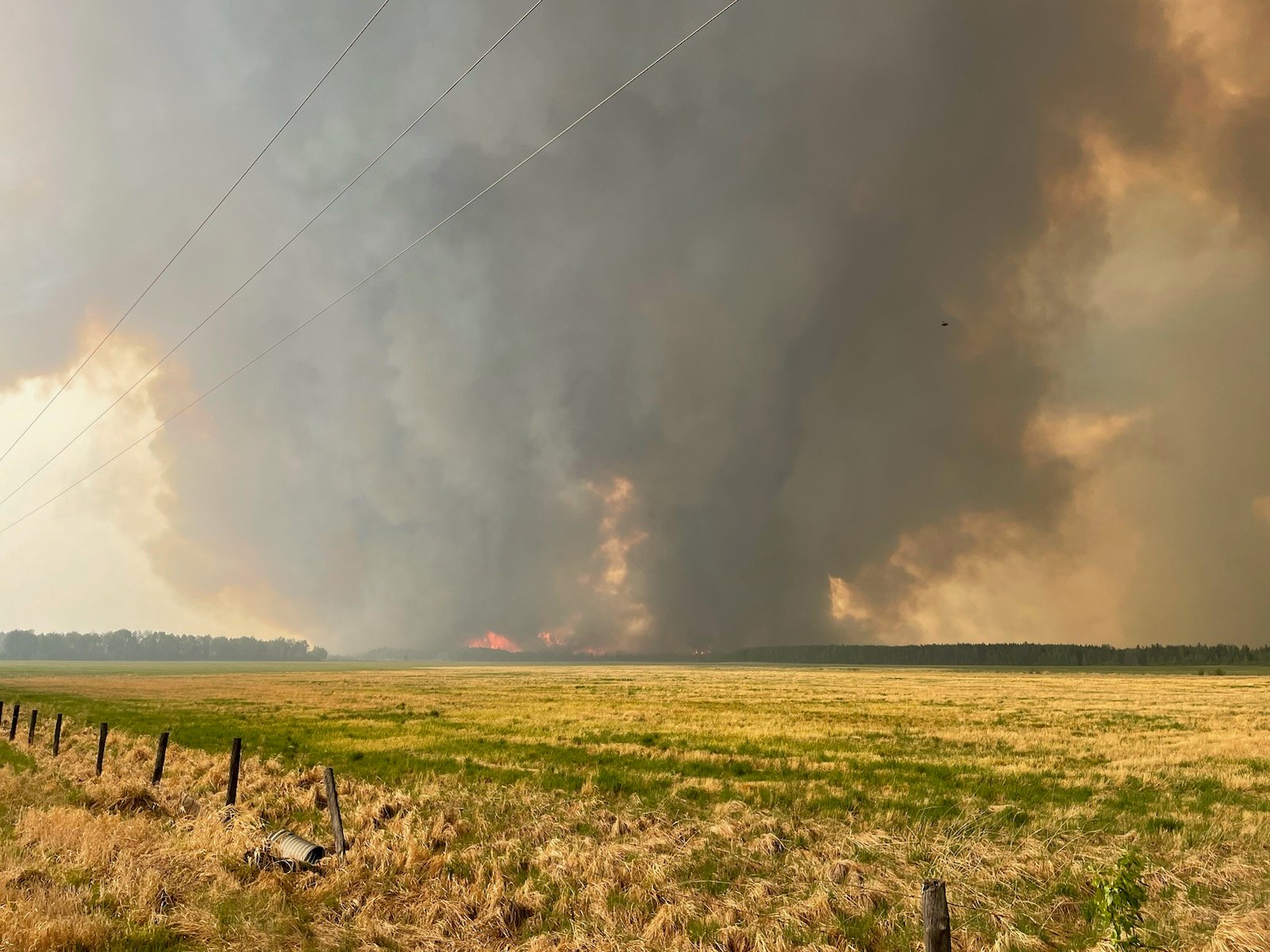 EWF035 from the corner of Range Rd 124 and Twp Rd 550. The fire is moving towards the south-southeast (May 19, 2023 at 3:45 p.m.)
NORTHWEST OF EWF035
Dozer operators and land owners were assisting with a dozer line to help contain the fire from the 560 moving south along East Bank Road, on the east side of the road. Although we appreciate the help from the public where possible, this is a special situation where the land owners are able to work closely with industry in ensuring the safety of the pipelines and the operators.
Today, firefighters began a hand ignition burning operation from East Bank Road and moving into the interior of the fire. This will add protection to nearby properties, removing available fuel for the fire later on, if the winds change direction. The operation is successful, the winds are in favor for firefighters and they'll continue on this road for the rest of the day. Residents will see smoke from this area, but the fire is being managed and monitored.
In the video below, the west side of EWF035 along East Bank and the river was very quiet this morning with just some wisps of smoke coming from hotspots. No concerns for the fire to jump the road, or the river at this time as winds are moving from the northwest to the southeast.
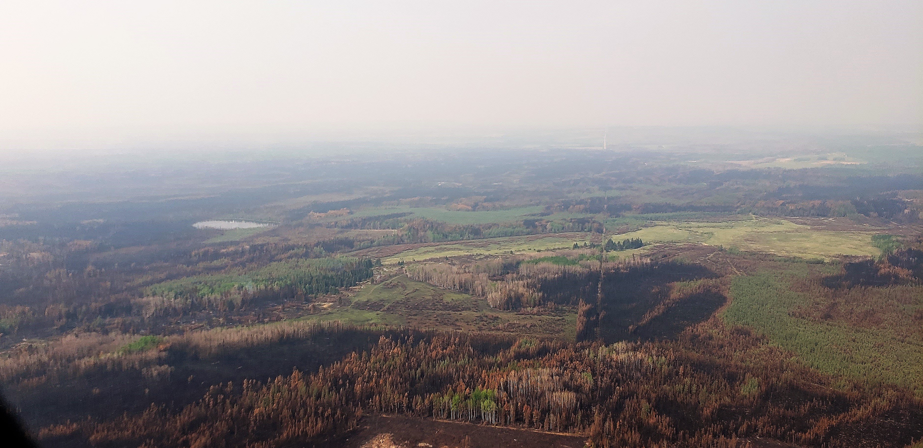
EWF035 - Hovering near Twp Rd 564 on the northwest of the fire looking towards the south. Very little smoke and no flame was visible this morning near the river (11:00 a.m.) (May 19, 2023).
NORTHEAST OF EWF035
The firefighters successfully established a containment line that runs from the 570 down to the 560 on the east side of the wildfire. They nearly completed the hand ignition burn operation, removing as much fuel as possible in the area. Firefighters had to cease their operations as relative humidity and the vegetation was too wet to burn. You can see in the photo below from this morning that most of the vegetation has now been burnt off and the dozer line is well established.
EWF035 dozer line was established on the northeast and firefighters successfully brought the line to the fire, removing available fuel.
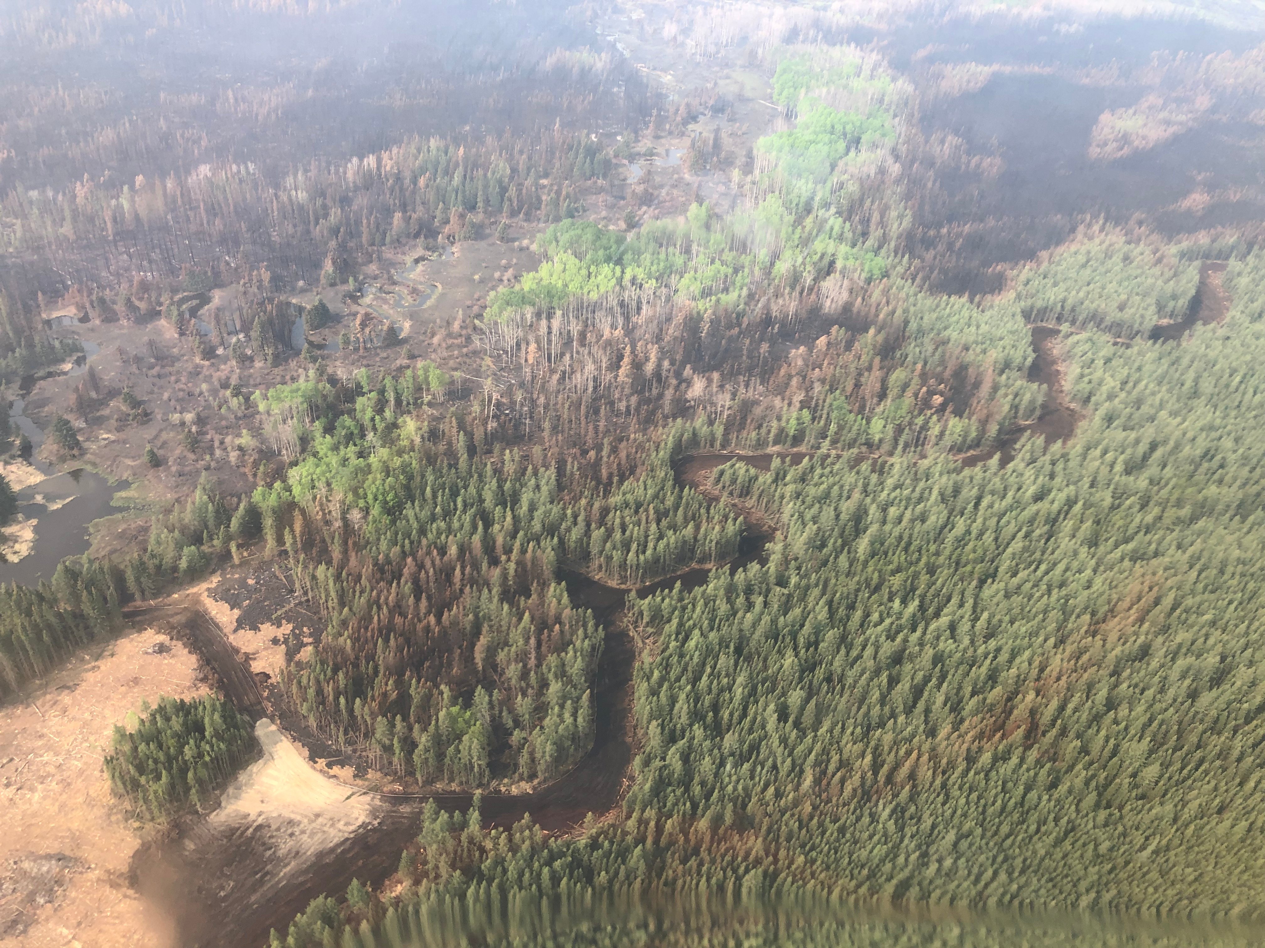
The fire continues to “hop and skip” (see photo below), mostly through spruce stands which are very flammable, especially in these weather conditions. In this area, the fire is burning easily through conifer (spruce) stands but slows down when it reaches deciduous (poplar/aspen) stands, or low, wet and swampy stand. Fortunately, the wildfire slows down when it reaches cut blocks as it has no substantial fuel to burn.
We ask that you stay out of these areas, if aircraft see members of the public near burning areas, they cannot do their job effectively. You may be unintentionally impeding our operations, please give our firefighters the room and time they need to complete their tasks.
A new map is available below. You can also use the NASA Link, which can be a useful tool. Be aware that the system may project ahead of itself, making the wildfire look larger than it is.
Aircraft will continue to report heightened wildfire activity areas to the ground and resources will work on priority areas.
Yellowhead County has reported that structural protection crews have been initiating their system over the last several days and are now prepared to action approximately 100 homes. Special flagging of different colours marked ‘SPU’ are set up on these properties to help firefighters identify operations for that property. This is to identify the placement of pumps and structural protection sprinklers. Please do not remove the flagging. Woodlands County and the Whitecourt Fire Department have also installed sprinkler protection on houses in the immediate area of EWF035 and will continue to monitor the situation as it continues. Woodlands County has strategically placed staff for night watch on EWF-035 to monitor for fire activity after dark. Alberta Wildfire is assisting Yellowhead County and Woodlands County with this wildfire.
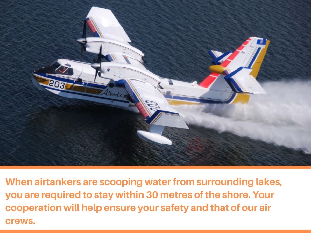
The Deep Creek Complex has a total of 44 firefighters plus 19 incident management firefighters working with 26 pieces of heavy equipment on this complex. Additionally, eight helicopters are assisting the wildfire with aerial assessments and performing bucket operations on the complex.
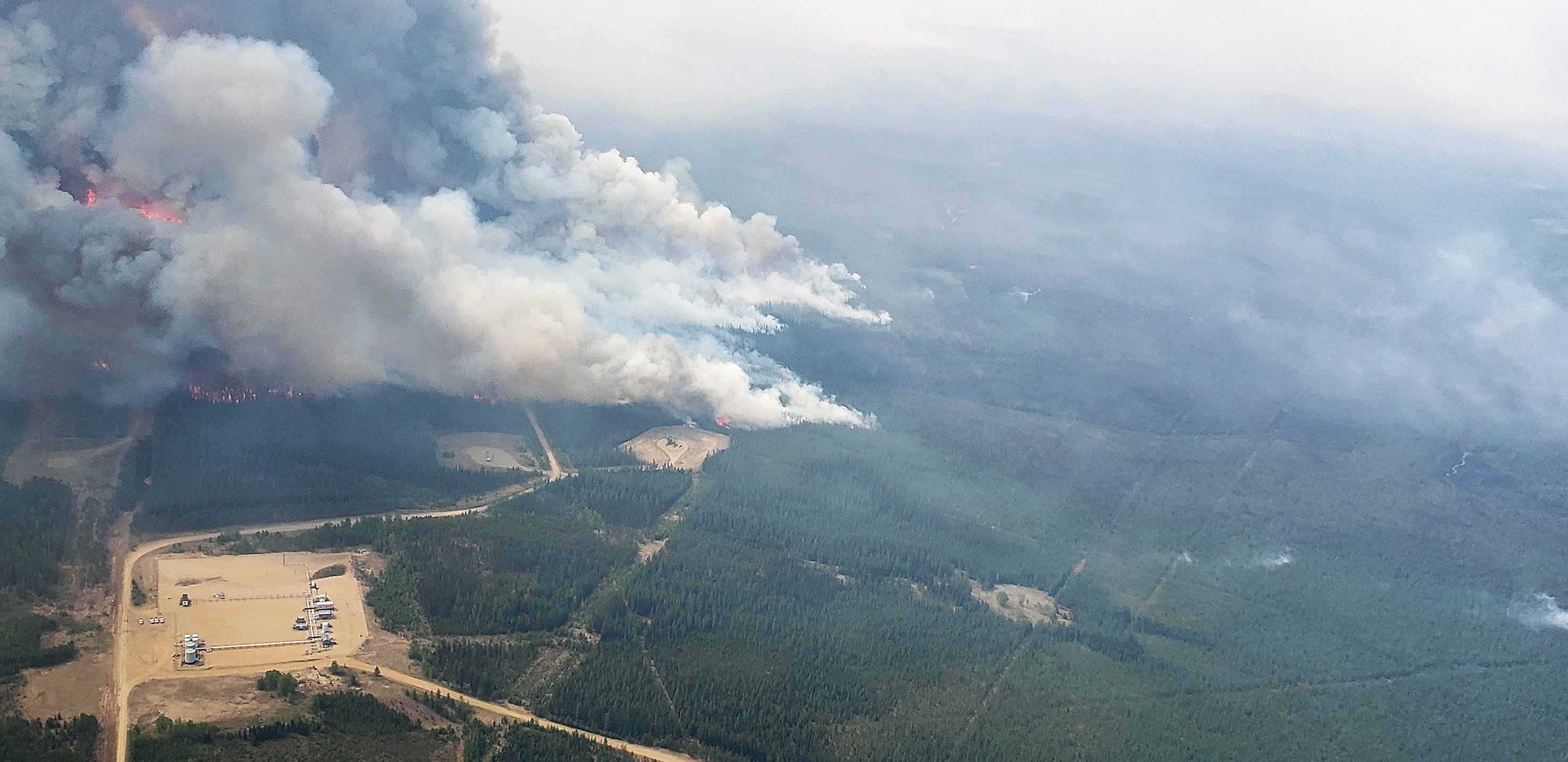
EWF035 is currently burning on the southeast side of the fire, moving east. Significant fire activity is being actioned by helicopters as of 11:30 a.m. (May 19, 2023)
 EWF035 is "hopping and skipping", not burning continuously through the forest. It burns intensely in spruce stands, but slows down in aspen/poplar stands. (May 19, 2023)
By: Caroline Charbonneau.
If you have any questions or concerns about the DEEP CREEK COMPLEX please call the Wildfire Information Officer - Caroline Charbonneau at 780-740-1341.
PUBLIC WILDFIRE MAPS
Edson Forest Area Overview Map - May 17, 2023 - public map - Click here.
Deep Creek Wildfire Complex (EWF-035, WCU002 and WCU001) May 17, 2023 - public map - Click here.
EWF035 Wildfire May 17, 2023 - public map - Click here.
Pembina Wildfire Complex (EWF031, EWF039, RWF034, RWF040) May 17, 2023 - public map - Click here.
EWF031 Wildfire May 17, 2023 - public map - Click here.
Note: The wildfire perimeter map is an estimate based on measurements such as GPS, aerial scanning and satellite imagery. This estimated perimeter can change as more accurate measurements become available. Areas within the fire perimeter may not have been affected by wildfire.
WILDFIRE LINKS AND TOOLS
Visit our Wildfire Dashboard to view active wildfires and their stats on the wildfire dashboard.
There are multiple EVACUATION ORDERS & ALERTS in the Province. Please visit Alberta Emergency Alerts or your community webpage for more information.
For road closure information, please visit: https://511.alberta.ca/#:Alerts
The NASA FIRMS Fire Information website is a great resource to give an idea of the location of wildfires in the area, but it should be noted that this data is based on interpolation and often can make a wildfire appear larger than it actually is.
Wildfire smoke is a tool used for the location of smoke firesmoke.ca
PROVINCIAL STATE OF EMERGENCY
Hot, dry conditions continue in most areas of the province resulting in numerous wildfires. A provincial state of emergency has been declared. Albertans who require assistance can call 310-4455 for wildfire related information - Click here.
DO NOT FLY DRONES NEAR WILDFIRES!
The use of recreational drones over wildfires in Alberta is dangerous, illegal and could result in a fine of up to $15,000* for putting aircraft and people at risk. Please give Alberta firefighters the space they need to do their jobs safely.
*Transport Canada
VOLUNTEER INFORMATION
Volunteers, equipment owners/operators or firefighters looking to assist with these wildfires or any of the wildfires within the province, please contact EmergencySupportOffers@gov.ab.ca. Please do not contact Edson Forest Area logistics directly, as they are extremely busy supporting the wildfire situation in the area. Thank you.
COMMUNITY EMERGENCY INFORMATION | EVACUATIONS
A MESSAGE FROM THE MUNICIPALITIES
If you are evacuating, gather important documents, medication, and enough food and water to be away from home for at least 3 days. Take pets with you.
For updates from Yellowhead County and Town of Edson, please visit their Facebook page: https://www.facebook.com/yellowheadcounty or www.yhcounty.ca for updates. Evacuees can call 1-833-334-4630 for more information.
For updates from Parkland County, please visit their Facebook page: https://www.facebook.com/ParklandCountyAB. Residents in the affected areas can contact the Emergency Information Line at 1-780-968-8888.
For residents with health concerns related to smoke you can find the air quality map here: https://www.alberta.ca/about-the-air-quality-health-index.aspx. If you have smoke related health concerns, please contact AB 811 and click here for more information.


WILDFIRE PREVENTION TIPS
Albertans are always asked to use caution when working or recreating in the outdoors:
- Before you burn it, get your fire permit. Fire permits in Alberta.
- Clear debris from hot spots on your off-highway vehicle.
- Ensure your campfire is out - soak it, stir it, soak it again.
- Before you head out this weekend, check out the albertafirebans.ca website or download the app to stay informed.
ALBERTA WILDFIRE INFORMATION
- Subscribe to the Edson Forest Area wildfire update to receive an email when new information is posted.
- Download the Alberta Wildfire App for Apple and Android device.
- Join the conversation on Facebook, Twitter or Instagram.
For more information, please contact: