

A FIRE BAN and OFF-HIGHWAY VEHICLE RESTRICTION is in effect for the Forest Protection Area of Alberta, including the Edson Forest Area.
Do not fly drones in an area of active wildfire. Drones halt air operations and we will have to wait for the airspace to be clear. Drones can endanger our aircraft and crews that are needed to work on the wildfire.
For previous Edson Forest Area Updates - Click here
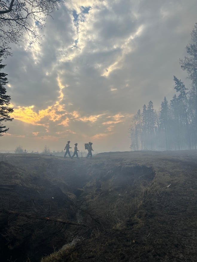 Firefighters walking for more gear on Deep Creek Complex yesterday (May 15, 2023).
GENERAL INFORMATION ON WILDFIRES IN OUR AREA
The forecast is calling for increasing temperatures, high winds, and low relative humidity continuing for the next few days. These conditions are likely to cause elevated wildfire danger and increased wildfire behaviour, which will be challenging to wildfire operations within the Edson Forest Area.
Firefighters, aircraft, and heavy equipment have been working in conjunction with county and municipal firefighting services as aggressively as possible to make progress on these wildfires while the conditions have been favorable. Despite all of this hard work, there are still hundreds of kilometers of uncontained wildfire perimeter and fire behaviour forecasts indicate that there will be growth on many of the wildfires throughout the region.
Smoke will be heavy today in the areas of Wildwood, Lobstick, Hansonville, Evansburg and Entwistle. Lingering smoke will be seen along highway 16 and highway 22 and in affected communities. A smoke inversion happens when cooler air is trapped near the ground by a layer of warmer air above it and the inversion will keep smoke close the ground level. Smoke inversions can cause dangerous driving conditions and impact nearby communities.
While we always appreciate people calling in to report wildfires, the large volume of calls we are currently receiving is diverting our resources away from other essential tasks. As always, please still call 310-FIRE if you see smoke or flame that looks new and potentially unreported, but assume that large columns of smoke and burned over areas have already been detected and reported. Thank you!
These wildfires remain under investigation. To learn more about wildfire classifications, click here.
ACTIVE WILDFIRES
PEMBINA WILDFIRE COMPLEX - EWF031/039, RWF034/040
EWF031 was detected on May 4 and is located 25 km west of Lodgepole, 20 km northwest of Brazeau Dam and 14 km southeast of Edson. The fire is classified as out of control and is estimated to be 82,666 ha in size. No significant growth has been observed since May 7, 2023.
There are 91 firefighters and support staff being shared between this fire and EWF039. An additional 20 personnel hotshot crew (similar to our unit crews) from the United States arrived yesterday and were working on the fireline today. There are 26 pieces of heavy equipment, and eight helicopters assigned to the complex. An airtanker group is still assigned to this fire. This group is composed of one birddog and five skimmers.
Today, crews were still positioned along the northwest area of the fire on both sides of the finger, which is the closest perimeter to the Town of Edson approximately 14 km away. They were working to secure wet line around this section of the fire. Wet line is defined as a line of water, or water and chemical retardant, sprayed along the ground, which serves as a temporary control line from which to ignite or stop a low-intensity fire. Another group of crews were working on south side of the northwest corner and continued working towards the south. Heavy equipment is still making great progress towards the completion of the containment lines from the Repsol Road working east past Wolf Lake Road.
Ground crews were conduction small scale ground ignitions on the far western tip of the south side at 1200 noon today. The purpose of this burn was to remove remaining fuel in between the fire perimeter and the planned containment lines in a controlled manner. The burn was successfully completed today. Future ignition opportunities will occur only if favorable conditions are available. Increased smoke may be visible to the Town of Edson and other surrounding communities.
This afternoon was more active on many parts of the wildfire. There is active burning in some areas such as the southeast side but is considered to be a "backing fire". A backing fire is a fire spreading, or ignited to spread, into (against) the wind or downslope. A fire spreading on level ground in the absence of wind is a backing fire. Some minor fire spread and increased fire behaviour was observed near Minnow Lake, and Wolf Lake, approximately two kilometres north of the Pembina River. Both areas are expected to continue producing large amounts of smoke over the coming days and will be highly visible to nearby communities.
A cold front will be present early Tuesday morning, at approximately 4 a.m., causing a rapid wind shift with sustained 15-20 km/h and gusting of 40-50km/h for the whole day. This shift will change wind direction from the south-southeast to north-northwest. This means the fire will be pushed in the south-southeast direction. The wind shift will also bring in smoke from the northern parts of B.C. and Alberta and potentially impact aviation operations by causing visibility issues. Cooler temperatures arrive tomorrow in the low 20’s and relative humidity in the high 20’s, but intense fire behaviour is expected through the week until Thursday.
EWF039 located near Carrot Creek, is currently being held. The fire is currently estimated to be 216 ha. The fire is fully wrapped in containment line and is a kilometer away from the Carrot Creek lookout tower. Crews have successfully left the area and will be repositioned on fire EWF031. Personnel are available to respond if necessary.
RWF034 Crews are utilizing direct attack along the south flank on established containment line. In addition mop up and hot spotting is occurring near and within the O’Chiese Reserve. On the north flank, crews are hotspotting and gridding to detect any remaining activity in this area in order to establish containment lines.
RWF040 is located 6 km northeast of the Forestry Trunk Road and Brown Creek Provincial Recreational Area and is classified as out of control. There are 76 firefighters and support staff shared between this fire and RWF034. The fire is currently estimated to be 2,200 ha in size.
If you have any questions or concerns about the PEMBINA COMPLEX please call the Wildfire Information Officer Sarah Hall at 250-318-8375.
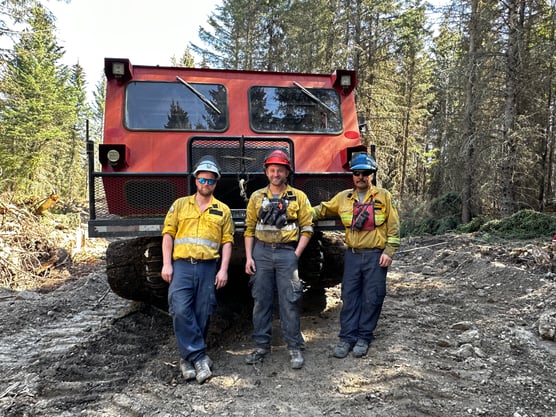
Crews at the start of the day on the Pembina Wildfire Complex (May 15, 2023)
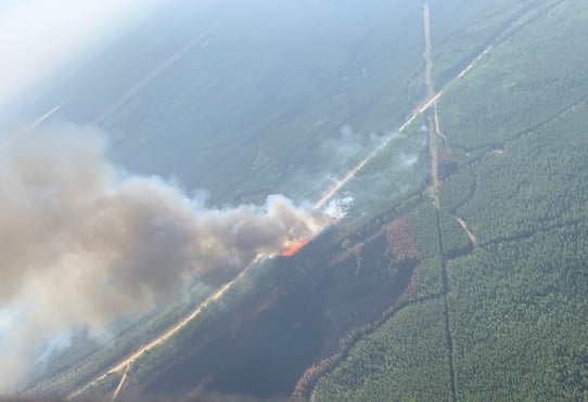
Ignition operations were successfully completed today on the Pembina Complex (May 15, 2023)
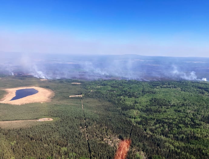
DEEP CREEK WILDFIRE COMPLEX – EWF035, WCU001 & WCU002
WCU001 was detected on April 29 and is classified as out of control. The wildfire remains at 7,281 ha in size, no new growth was recorded today. The wildfire zone is located southeast of Entwistle and west over the Pembina River where it spread north and travelled over Highway 16. The wildfire is parallel with Highway 16 and moved further west where the wildfire spread just north of Wildwood and now rests at Chip Lake.
Tomorrow, crews will work north of Wildwood and work their way east along Highway 16 extinguishing hotspots burning in deep peat. Wildfire crews are working in a heavily peated area just south of WCU001 but it is still within the perimeter. Wildfire intensity will pick-up and increase again tomorrow as temperatures and windy conditions persist. Highway 16 will experience smoke from the active wildfire zone due to the hotspots near the highway. There will be smoke north of Wildwood as crews work to extinguish a major hotspot area.
Tomorrow, we will have aircraft monitoring for flare-ups from above and they will report back to the ground crews to ensure that they stay within the already burned-out area to prevent spread. Many of the fuels that are burning off in the wildfire interior area are green trees within the burnt over zone that didn’t initially burn. Airtankers are available as requested. Alberta Wildfire is assisting Parkland County and Yellowhead County with this wildfire.
WCU002 was detected on the evening of April 29 and is a mutual aid wildfire located on both sides of Highway 22, north of Highway 16. The wildfire is currently burning out of control. The wildfire is estimated to be 2,401 ha in size, no new growth was detected today.
Tomorrow, smoke will be visible to residents in the area and it is from the interior of the fire. These areas of unburnt fuel are surrounded by burned out areas and are within the perimeter boundary. Smoke will linger along Highway 16 as crews work to extinguish hotspots. The wildfire has stayed south of Township Road 550 and east of Range Road 92 and west of Range Road 75. Alberta Wildfire and Yellowhead County are actioning this wildfire.
EWF035 was detected on May 5 and is located 3 km east of Shining Bank. This wildfire is classified as out of control and estimated to be 5,332 ha in size. The wildfire is south of Township Road 570, west of Range Road 123, north of Township Road 560 and east of Shining Bank Lake.
There are crews and heavy equipment allocated to the wildfire and they're working to establish containment lines to prevent further spread into rural properties. Tomorrow, groups of heavy equipment will continue working along the southeast side of the perimeter to create a fire break. Crews and helicopters will work to extinguish larger hotspots on the north boundary line tomorrow as they flare-up and create smoke.
Wildland firefighters expect growth to occur on the south-southeast of the fire perimeter of EWF035 potentially overnight and through the day tomorrow.
Aircraft will continue to report heightened wildfire activity areas to the ground and resources will work on those priority areas.
Yellowhead County has reported that structural protection crews have been initiating their system over the last several days and are now prepared to action approximately 100 homes. Special flagging of different colours marked ‘SPU’ are set up on these properties to help firefighters identify operations for that property. This is to identify the placement of pumps and structural protection sprinklers. Please do not remove the flagging. Woodlands County and the Whitecourt Fire Department have also installed sprinkler protection on houses in the immediate area of EWF035 and will continue to monitor the situation as it continues. Woodlands County has strategically placed staff for night watch on EWF-035 to monitor for fire activity after dark. Alberta Wildfire is assisting Yellowhead County and Woodlands County with this wildfire.
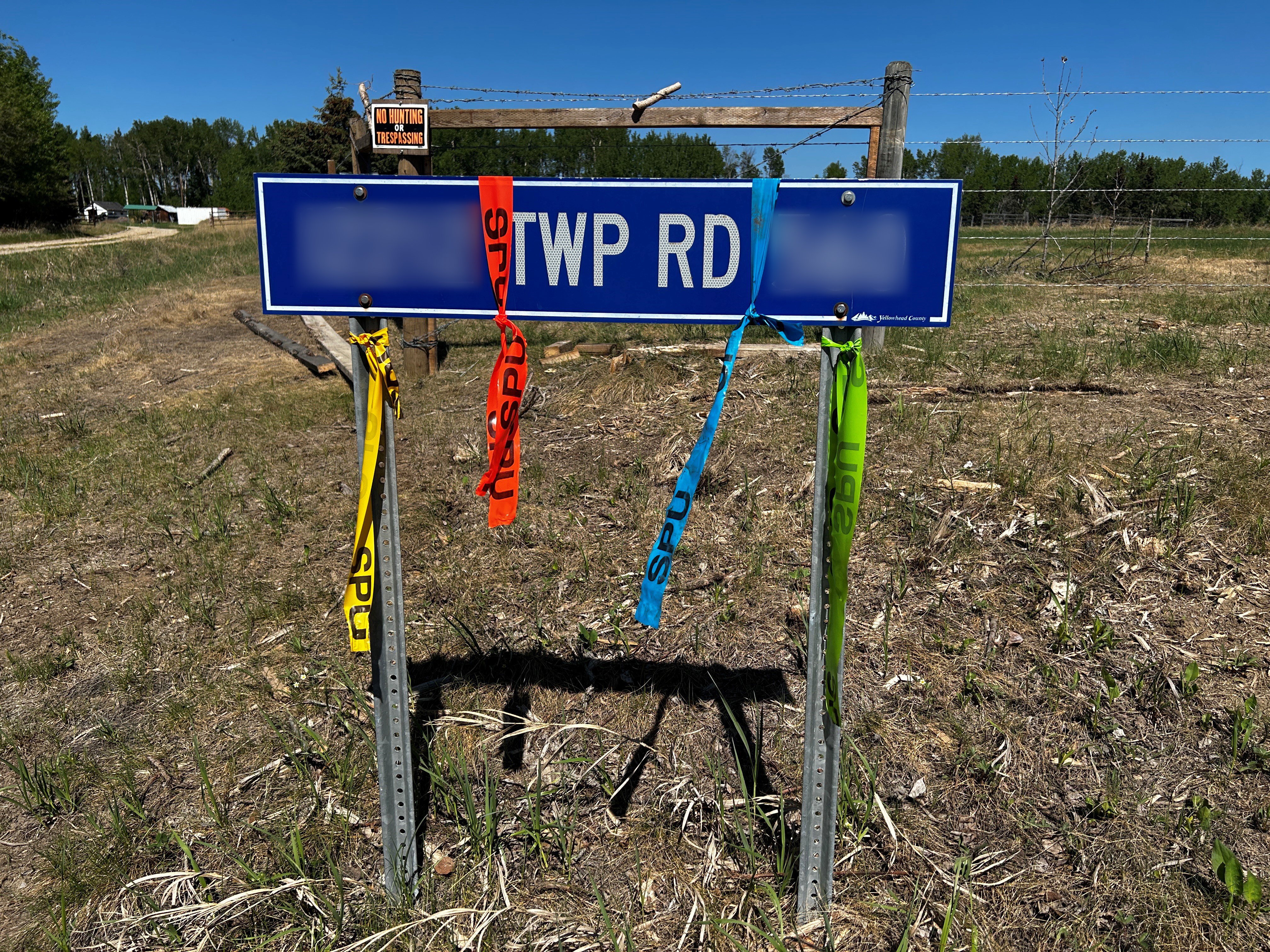 Yellowhead County asks that you do not remove flagging tape set up for structure protection equipment. (May 15, 2023)
The Deep Creek Complex has a total of 66 firefighters are working alongside 30 pieces of heavy equipment on this complex. Additionally, eight helicopters are assisting the wildfire with assessments and performing bucket operations on the complex.
Today the temperatures remained in the high 20's with winds out of the southeast at 15-20 km/h gusting to 25 km/h. Tonight, we anticipate a cold front which will bring northern winds and possibly push the wildfire towards the south. These winds will be 20-25 km/h gusting up to 50 km/h later tomorrow afternoon.
We encourage anyone who suspects a wildfire that is not indicated on our app to report it to 310-FIRE.
If you have any questions or concerns about the DEEP CREEK COMPLEX please call the Wildfire Information Officer - Caroline Charbonneau at 780-740-1341.
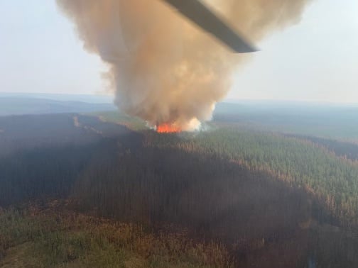
Smoke can be seen over EWF035 at noon today. Increased fire behaviour is expected this afternoon and into the evening - (May 15, 2023)
WILD HAY WILDFIRE COMPLEX - EWF037 and EWF040
There are multiple wildfires located south of the Little Smoky River, north of the Wild Hay River and east of Hwy 40 north. These also include the areas near the Willow Haul road and the Jack Wright road north of Hinton. These wildfires were formerly reported as five separate fires, but due to more accurate GPS measuring, have been determined to be two larger fires. EWF037 is out of control at 578 ha and EWF040 is out of control at 684 ha.
There was an increase in fire activity observed on the Wild Hay Wildfire Complex again today but no perimeter growth was reported despite this fire behaviour. Crews and equipment worked at containing this fire activity within the fire perimeter.
Increased fire activity observed on the Wildhay Wildfire Complex - (May 14, 2023)
PUBLIC WILDFIRE MAPS
Edson Forest Area Overview Map - May 14, 2023 - public map - Click here.
Deep Creek Wildfire Complex (EWF-035, WCU002 and WCU001) May 10th, 2023 - public map - Click here.
Pembina Wildfire Complex (EWF031, EWF039, RWF034, RWF040) May 9, 2023 - public map - Click here.
EWF035 Wildfire May 10, 2023 - public map - Click here.
Note: The wildfire perimeter map is an estimate based on measurements such as GPS, aerial scanning and satellite imagery. This estimated perimeter can change as more accurate measurements become available. Areas within the fire perimeter may not have been affected by wildfire.
WILDFIRE LINKS AND TOOLS
Visit our Wildfire Dashboard to view active wildfires and their stats on the wildfire dashboard.
There are multiple EVACUATION ORDERS & ALERTS in the Province. Please visit Alberta Emergency Alerts or your community webpage for more information.
For road closure information, please visit: https://511.alberta.ca/#:Alerts
The NASA FIRMS Fire Information website is a great resource to give an idea of the location of wildfires in the area, but it should be noted that this data is based on interpolation and often can make a wildfire appear larger than it actually is.
Wildfire smoke is a tool used for the location of smoke firesmoke.ca
PROVINCIAL STATE OF EMERGENCY
Hot, dry conditions continue in most areas of the province resulting in numerous wildfires. A provincial state of emergency has been declared. Albertans who require assistance can call 310-4455 for wildfire related information - Click here.
 DO NOT FLY DRONES NEAR WILDFIRES!
The use of recreational drones over wildfires in Alberta is dangerous, illegal and could result in a fine of up to $15,000* for putting aircraft and people at risk. Please give Alberta firefighters the space they need to do their jobs safely.
*Transport Canada
VOLUNTEER INFORMATION
Volunteers, equipment owners/operators or firefighters looking to assist with these wildfires or any of the wildfires within the province, please contact EmergencySupportOffers@gov.ab.ca. Please do not contact Edson Forest Area logistics directly, as they are extremely busy supporting the wildfire situation in the area. Thank you.
COMMUNITY EMERGENCY INFORMATION | EVACUATIONS
A MESSAGE FROM THE MUNICIPALITIES
If you are evacuating, gather important documents, medication, and enough food and water to be away from home for at least 3 days. Take pets with you.
For updates from Yellowhead County and Town of Edson, please visit their Facebook page: https://www.facebook.com/yellowheadcounty or www.yhcounty.ca for updates. Evacuees can call 1-833-334-4630 for more information.
For updates from Parkland County, please visit their Facebook page: https://www.facebook.com/ParklandCountyAB. Residents in the affected areas can contact the Emergency Information Line at 1-780-968-8888.
For residents with health concerns related to smoke you can find the air quality map here: https://www.alberta.ca/about-the-air-quality-health-index.aspx. If you have smoke related health concerns, please contact AB 811 and click here for more information.


WE URGE RESIDENTS AND RECREATIONALISTS TO USE EXTRA CAUTION
Due to the current dry grass, warm weather and possible windy conditions, there is an increased risk of wildfires in the Edson Forest Area. We urge residents and visitors to exercise caution and take the following precautions:
- Do not start any fires or use open flames in areas that are susceptible to catching fire, such as near dry vegetation like grass or wooded areas.
- Dispose of cigarettes and other smoking materials properly, do not throw them on the ground.
- If you see a wildfire, immediately call 310-FIRE (3473) and report the location of the fire.
- Avoid using equipment that could generate sparks, friction or flames, such as power tools or lawn mowers, in areas with dry vegetation.
- Ensure grinders and welders are properly maintained and used in areas that are free from dry vegetation. Have sufficient water and tools on hand. Always keep watch of your surroundings and look around at regular intervals for smoke or flames that may have been accidently ignited.
We encourage everyone to stay informed about the current wildfire risk and to follow any guidance or orders from emergency personnel. By working together and taking proactive steps, we can help reduce the risk of wildfires in our community.
WILDFIRE PREVENTION TIPS
Albertans are always asked to use caution when working or recreating in the outdoors:
- Before you burn it, get your fire permit. Fire permits in Alberta.
- Clear debris from hot spots on your off-highway vehicle.
- Ensure your campfire is out - soak it, stir it, soak it again.
- Before you head out this weekend, check out the albertafirebans.ca website or download the app to stay informed.
ALBERTA WILDFIRE INFORMATION
- Subscribe to the Edson Forest Area wildfire update to receive an email when new information is posted.
- Download the Alberta Wildfire App for Apple and Android device.
- Join the conversation on Facebook, Twitter or Instagram.
For more information, please contact: