

 DO NOT FLY DRONES NEAR WILDFIRES!
The use of recreational drones over wildfires in Alberta is dangerous, illegal and could result in a fine of up to $15,000* for putting aircraft and people at risk. Please give Alberta firefighters the space they need to do their jobs safely.
*Transport Canada
There are multiple EVACUATION ORDERS & ALERTS in the Province. Please visit Alberta Emergency Alerts or your community webpage for more information.
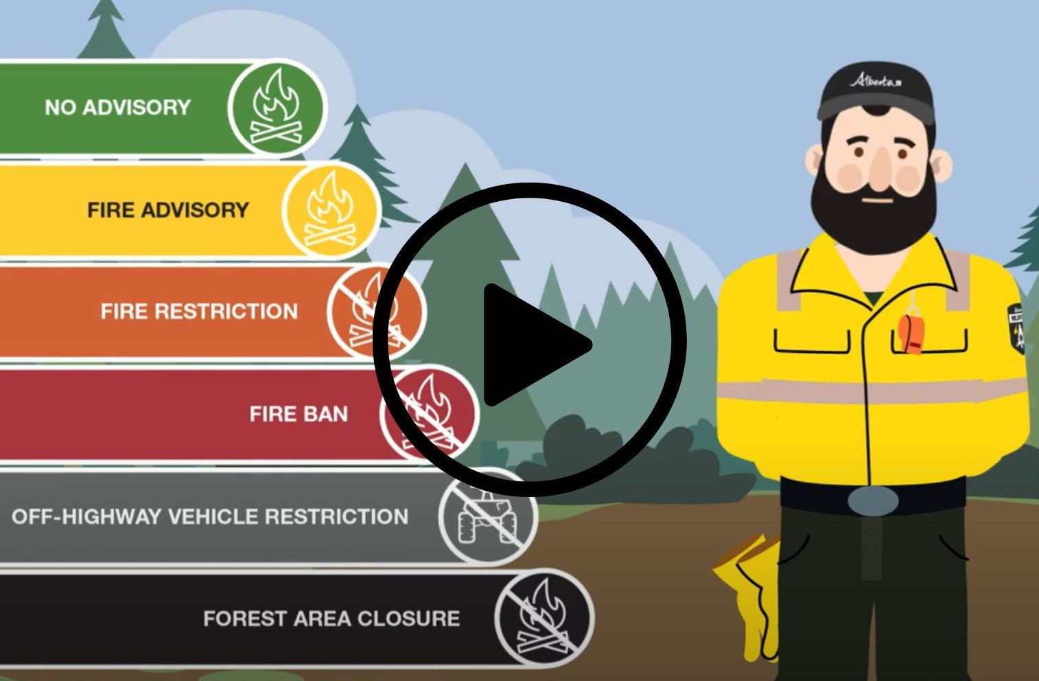
A FIRE BAN and OFF-HIGHWAY VEHICLE RESTRICTION is now effect for the entire Forest Protection Area of Alberta, including the Edson Forest Area.
Hot, dry conditions continue in most areas of the province resulting in numerous wildfires. A provincial state of emergency has been declared. Albertans who require assistance can call 310-4455 for wildfire related information - Click here.
GENERAL INFORMATION ON WILDFIRES IN OUR AREA
Most of these wildfires are due to the recent dry lightning that was seen over the past several days. This time of year, the trees are extremely dry as they have yet to absorb the moisture that they need. These are not normal conditions which is why we are witnessing an abnormal amount of fires igniting and spreading. The current hot and dry conditions are also contributing as we have been seeing crossover conditions over several consecutive days. This means that the humidity is lower than the temperature, making vegetation severely flammable which results in extreme fire behaviour.
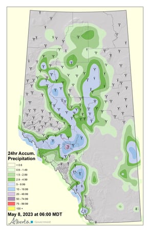
(Rain received over the past 24 hours - May 8, 2023)
The forecast is favorable for the next few days, with trace amounts of rain and overcast conditions in the area, which should assist with firefighting efforts. That said, not all areas will receive rain, and while every little bit helps, the long term forecast is predicting a return to hot and dry conditions within a few days, and the high/extreme fire danger is anticipated to resume. Because these wildfires have been so extremely hot and will have burned deep into the ground, these fires can re-ignite again even after several days of light rain, especially once these hot, dry and windy conditions return.
The NASA FIRMS Fire Information website is a great resource to give an idea of the location of wildfires in the area, but it should be noted that this data is based on interpolation and often can make a wildfire appear larger than it actually is.
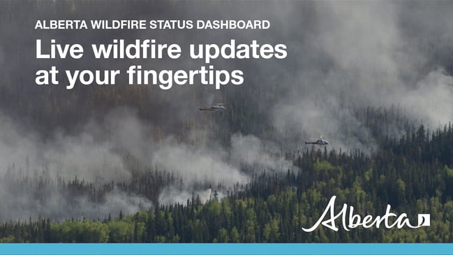
Visit our Wildfire Dashboard to view active wildfires and their stats on the wildfire dashboard.
For road closure information, please visit: https://511.alberta.ca/#:Alerts
Wildfire smoke is a tool used for the location of smoke firesmoke.ca
ACTIVE WILDFIRES
PEMBINA WILDFIRE COMPLEX - includes EWF031/039, RWF034/040
EWF031 was detected on May 4 and is located 25 km west of Lodgepole, 20 km northwest of Brazeau Dam and 14 km southeast of Edson. The fire is classified as out of control and was last estimated to be 77,920 ha in size. An Incident Management Team from British Columbia has arrived and will transition onto this fire today. The fire has not reached the McLeod River, or burned into the town of Edson. This wildfire saw low fire behaviour yesterday due to favourable weather conditions with lower temperatures and high relative humidity, and similar conditions are expected today. Heavy equipment continues to work on establishing guard along the north side of the fire, along with bucketing from heavy and medium helicopters.
EWF039 is currently burning out of control, estimated to be 216 ha in size and located near Carrot Creek. Structure protection has been put into place on critical infrastructure.
RWF034 is located near the O'Chiese Reserve and classified as out of control, and is estimated at 64,575 ha in size. There are 18 firefighters and support staff working on this wildfire along with helicopters and heavy equipment. Crews are focused on creating a fire guard at the South end of the fire near the O'Chiese Reserve.
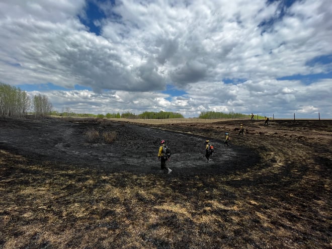
(Firefighters gridding on Deep Creek Complex - May 8, 2023)
Firefighters will walk in a grid pattern to physically map the location for hotspots that may be burning in an area.
DEEP CREEK WILDFIRE COMPLEX – includes EWF035, WCU001/002
While there are some areas that could have experienced some precipitation other areas may not. The wildfires in the area are extremely hot and will burn deep into the ground. These fires can re-ignite again if conditions are right. Mid-high temperatures and windy conditions will ignite fires that may look extinguished as they hide deep in the ground. There is still a risk to the communities affected by the Deep Creek Complex.
High levels of humidity will make it easier for crews and heavy equipment to build containment lines for communities that are still at risk. Today's forecasted weather may help with fire suppression efforts on the fireline but crews will need to be prepared for a change of higher temperatures into early this week and the increase in fire behaviour that it will bring.
WCU001 was detected on April 29 and is classified as out of control. The wildfire has been reassessed and is now 9,898 ha in size. The wildfire did cross west over the Pembina River and spread north where it did travel over highway 16. The wildfire continued to spread parallel with highway 16 as it moved further west where the wildfire spread just north of Wildwood and towards Chip Lake. Containment lines are being established for the north fire perimeter north of Wildwood. AB Wildfire is assisting Parkland County with this wildfire.
WCU002 was detected on the evening of April 29 and is a mutual aid wildfire located on both sides of Highway 22, north of Highway 16. The wildfire is currently burning out of control. The wildfire is estimated to be 2,400 ha in size. The fire is burning in a mixture of grass, shrub, trees and marsh. Both Yellowhead County and Alberta Wildfire are actioning this wildfire.
No growth has been reported today at this time. Resources are allocated to this fire. The wildfire has stayed south of Township Road 550 and east of Range Road 92 and west of Range Road 75.
EWF035 was detected on May 5 and is located 3 km southeast of Shinning Bank. This wildfire is classified as out of control and estimated to be 5,072 ha in size. This wildfire has crossed highway 32 and is being continually assessed by Alberta Wildfire. There are crews and heavy equipment allocated to the wildfire and they're working to establish containment lines to prevent further spread into rural properties. Over the coming days heavy equipment will start at the southeast fire boundary and work their way north and finally to the west to build a containment line. Today, airtankers dropped retardant lines to provide containment for the fire. These perimeter lines will help build-up containment on the north end of the wildfire as this is a priority area.
As we continue to see cloud cover over the complex creating higher levels of humidity and will help fighters in their suppression efforts. Ground fire will be present throughout the wildfire areas. AB Wildfire is assisting Yellowhead County and Woodlands County with this wildfire.
62 firefighters worked alongside 14 pieces of heavy equipment on the complex. Additionally, eight helicopters performed bucketing operations on the wildfires near affected communities.
Weather will remain mild but near the end of the week we will begin to see high temps and SE winds on Friday from the northeast at 10-15 km/h.
We encourage anyone who suspects a wildfire that is not indicated on our app to report it to 310-FIRE.
If you have any questions or concerns about the DEEP CREEK COMPLEX please call the Wildfire Information Officer at 780-653-0153 and press 2 for information.
WILD HAY WILDFIRE COMPLEX - EWF037/040/041/042/043
There are multiple clusters of wildfires located south of the Little Smoky River, north of the Wild Hay River and east of Hwy 40 north. These also include the areas near the Willow Haul road and the Jack Wright road north of Hinton. All of these wildfires are classified as out of control and are currently under investigation. These fires saw low fire behaviour and received rain throughout the day yesterday. A new assessment was made, and resources will be deployed accordingly.
The above wildfires remain under investigation. To learn more about wildfire classifications, click here.
PUBLIC WILDFIRE MAPS
Edson Forest Area Overview Map - May 6, 2023 - public map - Click here.
Deep Creek Wildfire Complex (WCU002 and WCU001) May 6th, 2023 - public map - Click here.
EWF031 Wildfire May 6, 2023 - public map - Click here.
EWF035 Wildfire May 5, 2023 - public map - Click here.
Note: The wildfire perimeter map is an estimate based on measurements such as GPS, aerial scanning and satellite imagery. This estimated perimeter can change as more accurate measurements become available. Areas within the fire perimeter may not have been affected by wildfire.
COMMUNITY EMERGENCY INFORMATION - EVACUATIONS
A MESSAGE FROM THE MUNICIPALITIES
If you are evacuating, gather important documents, medication, and enough food and water to be away from home for at least 3 days. Take pets with you.
For updates from Yellowhead County and Town of Edson, please visit their Facebook page: https://www.facebook.com/yellowheadcounty or www.yhcounty.ca for updates. Evacuees can call 1-833-334-4630 for more information.
For updates from Parkland County, please visit their Facebook page: https://www.facebook.com/ParklandCountyAB. Residents in the affected areas can contact the Emergency Information Line at 1-780-968-8888.
For residents with health concerns related to smoke you can find the air quality map here: https://www.alberta.ca/about-the-air-quality-health-index.aspx
If you have smoke related health concerns, please contact AB 811 click here for more information.


- All existing Fire Permits are suspended (or cancelled)
- No new Fire Permits will be issued
- All outdoor wood fires are banned, including wood campfires on public lands, wood campfires on private land and provincial campgrounds
- Backyard firepits
- BBQ charcoal briquettes
- The use of fireworks and exploding targets
- The recreational use of off-highway vehicles (OHV) on public lands, including designated OHV trails
- Propane/natural gas-powered appliances
- Open flame oil devices (e.g., turkey deep fryers, tiki torches)
- Indoor wood fires contained within a device with a chimney and spark arrestor
- All appliances must be CSA approved and used per manufacturer’s standards
- Indigenous people when using an OHV for traditional purposes. Traditional purposes are hunting, fishing, and trapping – including the use of an OHV to travel to the location(s) for these purposes.
- Essential industry-related activities requiring the use of OHVs.
- Off-highway vehicle use is still permitted on private lands.
Stay tuned to www.albertafirebans.ca throughout the wildfire season for more information about fire bans and restrictions in the Forest Protection Area of Alberta.
WE URGE RESIDENTS AND RECREATIONALISTS TO USE EXTRA CAUTION
Due to the current dry grass, warm weather and possible windy conditions, there is an increased risk of wildfires in the Edson Forest Area. We urge residents and visitors to exercise caution and take the following precautions:
- Do not start any fires or use open flames in areas that are susceptible to catching fire, such as near dry vegetation like grass or wooded areas.
- Dispose of cigarettes and other smoking materials properly, do not throw them on the ground.
- If you see a wildfire, immediately call 310-FIRE (3473) and report the location of the fire.
- Avoid using equipment that could generate sparks, friction or flames, such as power tools or lawn mowers, in areas with dry vegetation.
- Ensure grinders and welders are properly maintained and used in areas that are free from dry vegetation. Have sufficient water and tools on hand. Always keep watch of your surroundings and look around at regular intervals for smoke or flames that may have been accidently ignited.
We encourage everyone to stay informed about the current wildfire risk and to follow any guidance or orders from emergency personnel. By working together and taking proactive steps, we can help reduce the risk of wildfires in our community.
WILDFIRE PREVENTION TIPS
Albertans are always asked to use caution when working or recreating in the outdoors:
- Before you burn it, get your fire permit. Fire permits in Alberta.
- Clear debris from hot spots on your off-highway vehicle.
- Ensure your campfire is out - soak it, stir it, soak it again.
- Before you head out this weekend, check out the albertafirebans.ca website or download the app to stay informed.
ALBERTA WILDFIRE INFORMATION
- Subscribe to the Edson Forest Area wildfire update to receive an email when new information is posted.
- Download the Alberta Wildfire App for Apple and Android device.
- Join the conversation on Facebook, Twitter or Instagram.
For more information, please contact: