

A Fire restriction is in effect for the Edson Forest Area. We are urging the public to use the utmost care when working and recreating in the outdoors.
In the event of a wildfire, extreme fire behaviour is anticipated. Extreme fire behavior means long flame lengths, faster moving fire, long range spotting of embers and greater potential for the fire to climb from the ground into the forest canopy and spread quickly. This creates serious fire control problems for firefighters.
If you see smoke or flame and suspect it's a wildfire, call 310-FIRE.
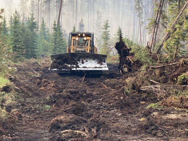
Heavy equipment worked quickly and efficiently to complete the containment line surrounding EWF096 located 21 km east of Robb (July 3, 2021).
NEW WILDFIRE DETECTIONS
There are currently multiple wildfires being detected in our forest area. Many are believed to have been caused by lighting strikes in the past two days. These types of wildfires can smolder deep into the ground for days and even weeks and flare when the conditions are right. We would like to remind everyone, if you see smoke or flame in the forest, call 310-FIRE.
EWF098, 099 are currently being assessed by firefighters. They are all recorded to be 0.01 ha in size.
EWF097, EWF091 are OUT OF CONTROL (095 and 092 are UNDER CONTROL) They are located within 12 km of each other. The closest wildfire is 10 km north of Marlboro and 27 km west north west of Edson. All three are less then 0.5 ha in size. There are currently four firefighters actioning these wildfires. Firefighters are currently making good progress on these fires and will work late into the evening to contain them.
EWF093 and EWF094 are burning OUT OF CONTROL 12 km north of Cynthia and 73 km south east of Edson on the east side of highway 753. Both are 2.5 km from each other and burning towards the east. EWF093 is now estimated to be 50 ha in size and EWF094 is 1.5 ha. There are currently 12 firefighters, six airtankers and four helicopters actioning these wildfires.
On wildfire 093, heavy equipment and firefighters will continue to build containment line around the wildfire's perimeter late into the evening. Tomorrow morning, 46 firefighters and four helicopters will continue to reinforce the line and search for and extinguish hotspots.
EWF096 is burning OUT OF CONTROL 21 km east of Robb. This wildfire is estimated to be 10 ha in size. Heavy equipment are currently working to complete dozer guard around the fire. Twenty firefighters will be working late this evening, and returning tomorrow morning along with three helicopters to reinforce the containment line.
There are no communities being affected by the wildfires at this time. The cause is under investigation.
To view the wildfires on a map, download the new AB Wildfire Status App.
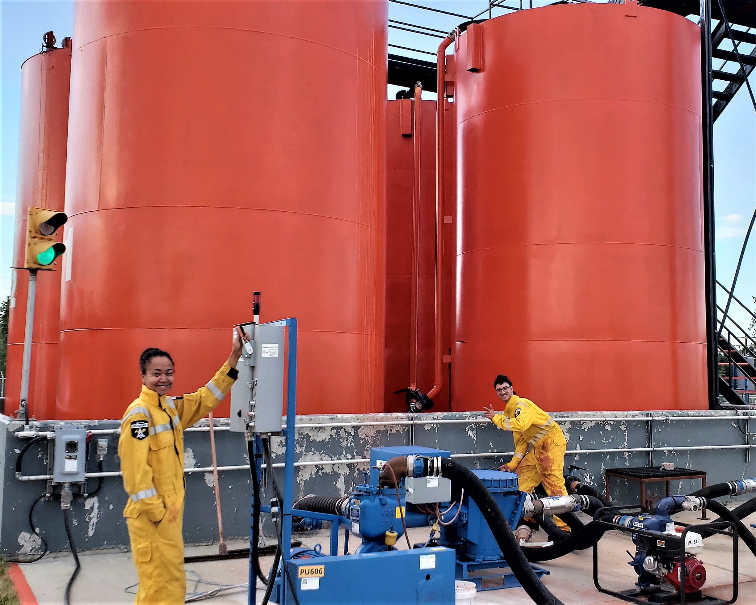
The Edson Airtanker Base crew has been busy loading aircraft with fire retardant (July 3, 2021).
EDSON FOREST AREA FIRE DANGER RATING
The wildfire danger in the Edson Forest Area remains EXTREME. In the event of a wildfire, extreme fire behaviour is anticipated. In preparation, we have pre-positioned our firefighters, aircraft and equipment in key areas to enable them to respond quickly to new wildfires.
EDSON FOREST AREA WILDFIRE UPDATE
Since March 1, 2021, there have been 98 wildfires in the Edson Forest Area burning a total of 815 ha.
EWF087 is now BEING HELD. This means that given current weather conditions and resources, the wildfire is not anticipated to grow past expected boundaries. The fire was detected on July 2 at 7:00 a.m. It is located 35 km south east of Edson, 500m west of the Repsol Road.
EWF086 is now BEING HELD. The fire was detected on July 1 and is located 20 km south west of Edson south of highway 47 near the Sundance Road. The wildfire was reassessed and is now estimated to be 2.8 ha in size.
EWF075 was detected on June 22 and is classified as BEING HELD. The wildfire is located 9 km west of Evansburg, north of highway 16 and west of highway 22. The wildfire is 175 hectares in size. No new growth has been reported since the evening of June 22. Firefighters from across the province are searching for and extinguishing hotspots. They will remain vigilant until the wildfire is fully extinguished.
EWF036 was detected on April 30 and is estimated to be 479 ha in size. The wildfire remains classified as UNDER CONTROL and is located 20 km south of Carrot Creek, 25 km north west of Cynthia and 45 km south east of Edson. Crews will continue to monitor for hotspots until it is determined to be fully extinguished.
The wildfires pose no threat to any communities at this time. The cause of the wildfires are currently under investigation.
To understand what the wildfire classifications mean, visit our website by clicking here.
PROVINCIAL WILDFIRE UPDATE
Since March 1 in the Forest Protection Area, there have been 672 wildfires burning a total of 3,309 ha.
For more information on the current wildfire situation across the province of Alberta, visit wildfirestatus.alberta.ca
SMOKE RELATED HEALTH CONCERNS
Please be advised that smoke from multiple wildfires outside of our forest area can be seen. No wildfire in our forest area is producing smoke except for EWF075 located 9 km west of Evansburg. To learn more about smoke produced by wildfires, visit firesmoke.ca. For smoke related health concerns, please visit Alberta Health Services, click here.
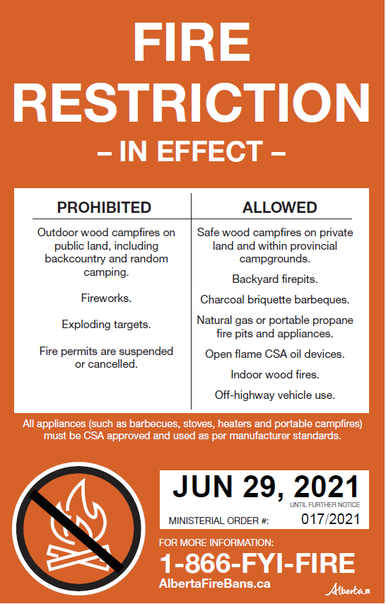
To view the Ministerial Order: https://wildfire.alberta.ca/wildfire-status/ministerial-orders.aspx
WILDFIRE PREVENTION TIPS
Albertans are always asked to use caution when working or recreating in the outdoors:
-
Before you burn it, get your fire permit. Fire permits in Alberta.
-
Clear debris from hot spots on your off-highway vehicle.
-
Ensure your campfire is out - soak it, stir it, soak it again.
-
Before you head out this weekend, check out the albertafirebans.ca website or download the app to stay informed.

ALBERTA WILDFIRE INFORMATION
- Subscribe to the Edson Forest Area wildfire update to receive an email when new information is posted.
- Download the Alberta Wildfire App for Apple and Android device.
- Join the conversation on Facebook, Twitter or Instagram.
For more information, please contact: