

Wildfire Update | May 19 @ 10:00 a.m.
There are two wildfires in the Whitecourt Forest Area.
Note: The Wildfire in the Little Smoky area (WWF-025) is now called the Iosegun Lake Fire
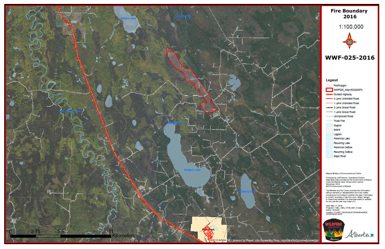
Iosegun Lake Fire (WWF025)- started at 1:00 p.m. May 15. As of 7:30 p.m. May 18 it was classified as BEING HELD - meaning the wildfire is not expected to grow past its current boundaries. The wildfire has not grown for 48 hours and remains 657 hectares in size. 95 percent of the perimeter of the wildfire is secured with fireguard. The most up to date map of the wildfire is here.
Rain over the wildfire started last evening and continues right now. As of 9:00 a.m. this morning there was already 13 millimetres of rain on the ground. The forecast for today calls for the rain to continue. A welcome relief for firefighters. Once the rain lightens, the hard work of digging deep into the the soil and root system will begin. This is the next step in fully extinguishing the wildfire; this type of work is hard and takes a long time.
The north end of the wildfire remains 8 kilometres south east of the nearest community, Little Smoky. On the south end of the wildfire, it remains 11 kilometres north of the Town of Fox Creek. Currently no communities or critical infrastructure are threatened.
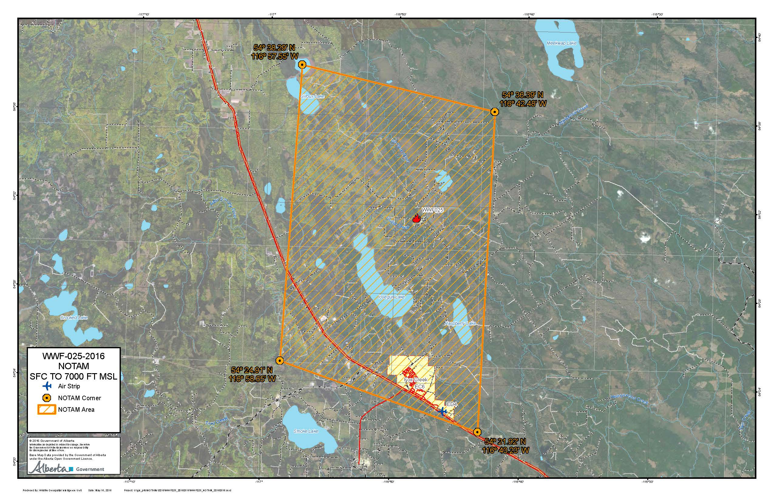
NOTAM remains in effect for the air space around the wildfire WWF025 for air operations. All aircraft require permission to enter the air space. It is in effect until May 24 at 12:00hrs. Read more here.
86 firefighters, 3 helicopters and various pieces of heavy equipment continue working to extinguish this wildfire.

Image: United we stand. Firefighters from across North America have been fighting wildfire WWF-025.
Wildfire west of Highway 32 (WWF-026) - started at 9:17 p.m. May15. It is classified as UNDER CONTROL at 1.9 hectares in size and is located 10.5 kilometres north west of Carson-Pegasus Provincial Park; on the west-side of Highway 32. Firefighters will continue to monitor the site until it is fully extinguished.
Wildfire Hazard
The wildfire hazard is LOW for the Whitecourt Forest Area.Rain is finally here! The forecast this weekend is for heavy rain amounting to 20-30 millimetres. Wind direction will be northwest at 30 kilometres per hour gusting up to 50 kilometres per hour. There is a chance of snow overnight.

A Fire Ban remains in effect for the northern and central parts of the province of Alberta, including the Whitecourt Forest Area .

NOTE: The Fire Ban includes all counties, municipal districts and special areas, as well as provincial parks and recreation areas. It does not apply to cities, towns, villages, summer villages, or federal lands, such as national parks. A county or municipal district may decide to add additional restrictions – please check the new Alberta Fire Ban website for more information.

The use of off-highway vehicles (OHV) for recreational use on all public lands within Whitecourt Forest Area and the northern and central portion of the province of Alberta are restricted to help prevent the spread of wildfires.
- Off-highway vehicles are defined as any all-terrain vehicle (ATV), four-wheel vehicles, motorcycles and related two-wheel vehicles and amphibious machines.
- If Albertan's are witnessing restricted OHV activities they can call the Report a Poacher Line at 1-800-642-3800.
- For more information you can visit emergency.alberta.ca.
No one knows when an emergency will happen - but you can be prepared.
- Sign up for the free emergency alert app to get up to the minute alerts and updates on evacuations and other emergencies in the province pushed to your device.
- Please visit www.emergencyalert.alberta.ca for a listing of all evacuations currently in effect in Alberta.
- For information on how you can prepare yourself for the event that an evacuation is necessary, visit www.aema.alberta.ca/72-hour-emergency-kit

Unless conditions change, your next update will be on May 23, 2016.
