

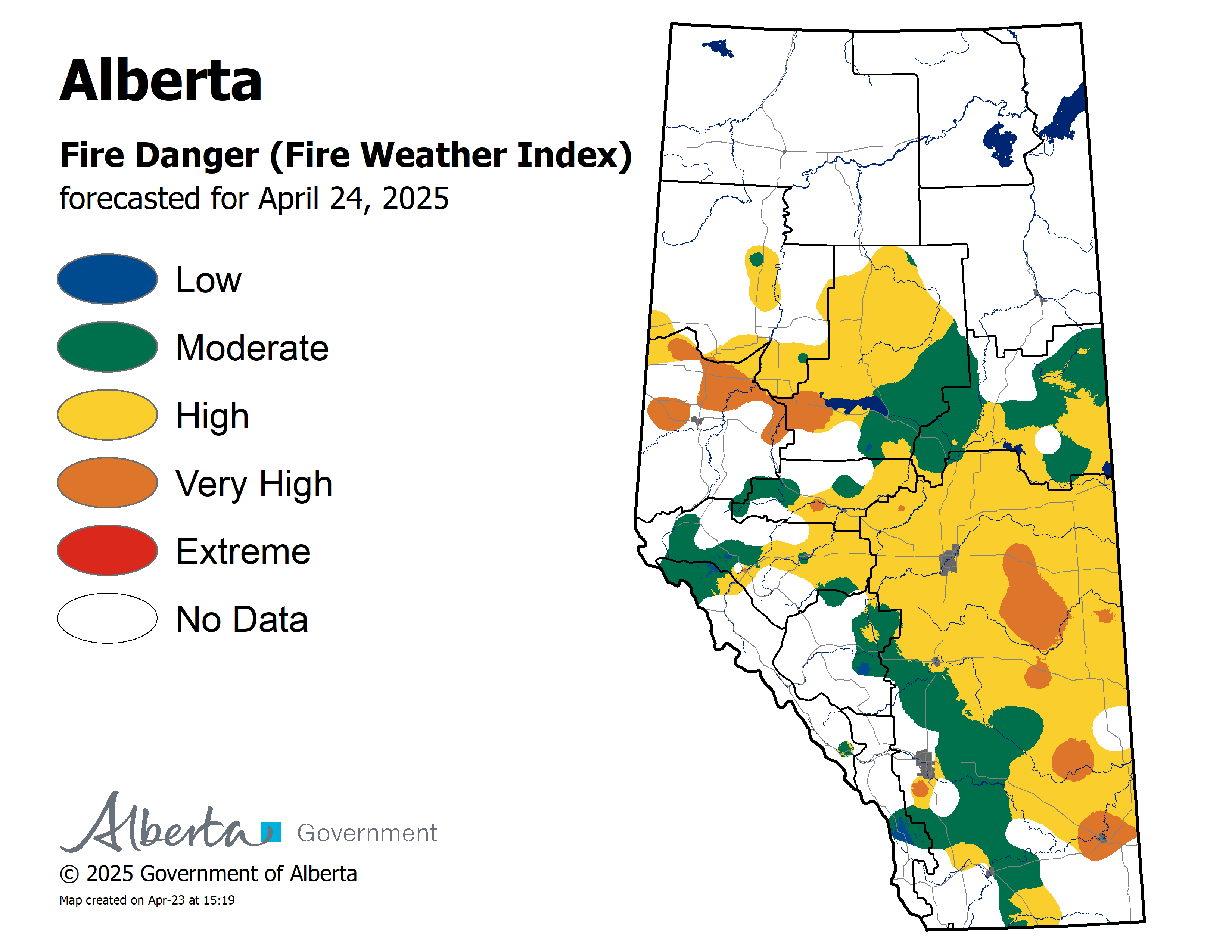
Wildfire danger
Rain is a welcome sight however at this time the rain has not reached areas north of Lesser Slave Lake.
The wildfire danger is High to Extreme for areas north of Lesser Slave Lake. Click here to view the wildfire danger map for today.
At this time the Fire Ban/OHV Restriction remain in effect for the entire Slave Lake Forest Area and other parts of Alberta.
To view a map and information about the fire ban/OHV restriction visit www.albertafirebans.ca
To view a fact sheet on the OHV restriction click here.
To view a fact sheet on the fire ban click here.
Firefighters are urging everyone to use caution and report wildfires immediately by calling 310-FIRE or #FIRE on your cell phone.
Keep up to date by downloading the Alberta Emergency Alert App or visit www.emergencyalert.alberta.ca
For road conditions visit www.511.alberta.ca
Smoky conditions are expected to continue
Over the next several days wildfire smoke will continue to drift into the Slave Lake Forest Area.
If you experience respiratory difficulties, visit Alberta Health Link or dial 811. Visit www.firesmoke.ca to view the most current smoke forecast.
Click here for Alberta Health Services Information about Wildfire Smoke.
New Wildfire Starts
Firefighters, helicopters and airtankers are fought 11 new wildfires caused by the lightning. Nine of the wildfires are small and firefighters are working to extinguish them.
SWF-090 is 19 kilometres northeast of Trout Lake.Currently the size is 100 hectares.
SWF-093 is located 11 kilometres south of Chipewyan Lakes.Currently the size is 150 hectares.
These wildfires are not threatening communities.
Since the start of the wildfire season on March 1st, there have been 96 wildfires and 299, 406 hectares burned in the Slave Lake Forest Area.
For information on the wildfire situation across the province of Alberta, visit: wildfire.alberta.ca.
Wildfire Update McMillan Complex
The wildfire experienced minimal growth yesterday.
Firefighters performed a successful prescribed burn on the southwest side of the fire.
Firefighters confirmed that SWF-049 and SWF-069 have merged. The new size of SWF-049 is 238,254 hectares.
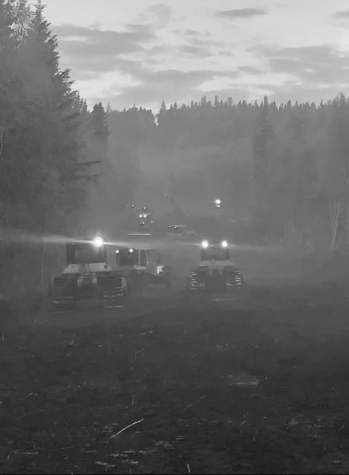
12 kilometers of fire guard has been completed around the west and south sides of the wildfire.
Today firefighters are working from the fire guards to extinguish ground fires and heavy equipment continue to build fire guard.
There is a chance the rain may reach the wildfire later this morning or early afternoon. At this time, no rain has been recorded for areas north of Lesser Slave Lake.
The wildfires are:
- 5.8 and 3.7 kilometres west of Wabasca No. 166B and 166D
- 26.5 kilometres northeast of Marten Beach
- 32.8 kilometres northeast of Slave Lake
- 9.3 kilometres southeast of Trout Lake
SWF-049 is 238,254 hectares and is classified as out of control.
SWF-078 is 162 hectares and is classified as out of control.
SWF-079 is 355 hectares and is classified as out of control.
There are 323 firefighters and support staff, 35 helicopters, and 60 pieces of heavy equipment fighting this wildfire.
Click here to view a map of the McMillan Wildfire Complex.
Click here to view a map of the wildfires burning in Alberta.
Alberta Wildfire Information booths are set up in the following locations;
- Calling Lake Evacuation Centre
- Walmart in Slave Lake 6:00 pm - 9:00 pm
Information Officers will also be visiting the community of Peerless Lake today.
Weather
For Monday the temperature will be 16 degrees and winds will be from the southwest/west 20 kilometres per hour gusting up to 40. Rain is in the forecast for areas south of Lesser Slave Lake.
On high alert
Fire lookouts are on high alert constantly watching for smoke and firefighters in helicopters, various pieces of heavy equipment and airtankers are ready to respond to any new wildfires that may start.

FIRE BAN AND OFF-HIGHWAY VEHICLE RESTRICTION IN EFFECT
A fire ban and off-highway vehicle restriction is in effect for the entire Slave Lake Forest Area and other parts of Alberta.
The Town of Slave Lake, Big Lakes County and Town of High Prairie have issued a fire ban and OHV restriction.
To view a map of the fire ban/OHV restriction area visit www.albertafirebans.ca
To view a fact sheet on the OHV restriction click here.
To view a fact sheet on the fire ban click here.
Prohibited
If you have any questions please contact:
Leah Lovequist
Wildfire Information Officer
Mobile: 780-849-0945
Email:leah.lovequist@gov.ab.ca
Keep up to date on the wildfire situation by subscribing to the Slave Lake Forest Area Wildfire Update or download the free Alberta Wildfire app for Apple or Android devices.


