

Wildfire Danger
The wildfire danger remains Very High for areas north of Lesser Slave Lake. Click here to view the wildfire danger map for Saturday.
The rainfall yesterday was minimal north of Lesser Slave Lake.
Fire Ban and OHV Restriction remain in place for areas north of Lesser Slave Lake. To view a map of the Fire Ban/OHV restriction area visit www.albertafirebans.ca
To report a wildfire call 310-FIRE or #FIRE on your cell phone.
Smoky conditions are expected today
Over the next several days wildfire smoke will continue to drift into the Slave Lake Forest Area.
If you experience respiratory difficulties, visit Alberta Health Link or dial 811. Visit www.firesmoke.ca to view the most current smoke forecast.
Click here for Alberta Health Services Information about Wildfire Smoke.
New Wildfire Starts
There were two new wildfire starts yesterday. SWF-100 is located west of Loon Lake, is classified as under control and is 2.5 hectares in size. 8 firefighters and 2 helicopters are working on this fire.
SWF-101 is located north of Sandy Lake and is 0.95 hectares in size. 9 firefighters and 1 helicopter are fighting this fire and it is classified as being held.
17 firefighters and three helicopters continue to fight SWF-093 which is located 11 kilometres south of Chipewyan Lakes. It is classified as being held and is 98 hectares.
Since the start of the wildfire season on March 1st, there have been 101 wildfires and 317,559 hectares burned in the Slave Lake Forest Area.
For information on the wildfire situation across the province of Alberta click here.
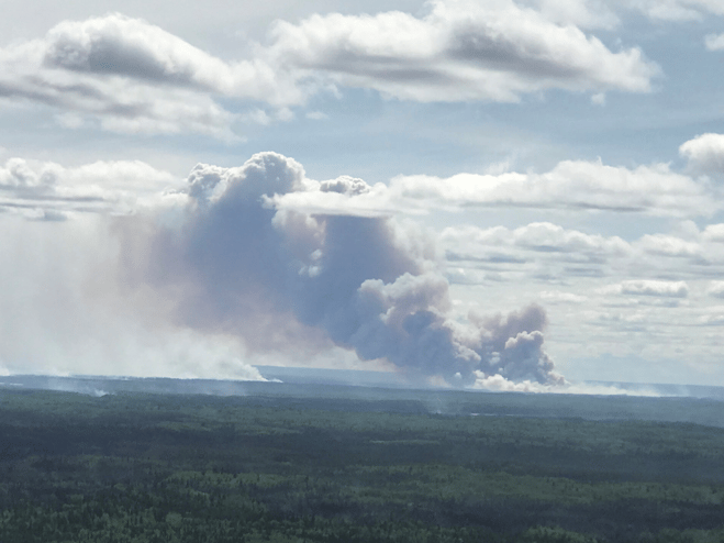
Photo taken June 7th of the south-east side of SWF-049. Helicopters with buckets and heavy equipment were working on this area.
McMillan Wildfire Complex
Crews continue to patrol and monitor control lines along the fire perimeter in the vicinity of Wabasca. Now crews are laying hose northwest on the east side of the fire. They are also establishing helipads further north on the east side of the fire.
Crews are putting in helipads on the northwest side of the fire and looking to use ignition under favourable conditions to bring the fire to safe boundaries.
Firefighters will be laying hose along the west side of the fire at several key points to form control lines on this section of the fire.
Patrolling continues in the Marten Lake Road area.
Structure protection is complete at Trout Lake, Wabasca, Bigstone Cree First Nation and Marten Beach. Structure protection crews will be maintaining sprinkler systems at these sites. Structure protection is planning and prepping sprinkler systems for the community of North Wabasca.
The wildfires are:
- 4.9 and 3.3 kilometres west of Wabasca No. 166B and 166D
- 26.5 kilometres northeast of Marten Beach
- 32.8 kilometres northeast of Slave Lake
- 9.3 kilometres southeast of Trout Lake
SWF-049 is 255,873 hectares and is classified as out of control.
SWF-078 is 137 hectares and is classified as under control.
SWF-079 is 877 hectares and is classified as out of control.
SWF-090 is 185 hectares and is classified as under control.
SWF-099 is 2 hectares and is classified as being held.
There are 379 firefighters and support staff, 38 helicopters, airtankers and 43 pieces of heavy equipment fighting this wildfire.
Click here to view a map of the McMillan Wildfire Complex.
Click here to view a map of the wildfires burning in Alberta.
An Alberta Wildfire Information booth is set up at the Calling Lake Evacuation Centre.
Wildfire Information Officer for the weekend is Becky Heemeryck, she can be reached at (403)844-0808
Alberta Emergency Alert
The communities of, Hamlet of Wabasca, Bigstone Cree Nation - Wabasca # 166, and Chipewyan Lake Village are evacuated and the public must not be in these areas. There is heavy smoke in the area and numerous road closures due to the wildfires. Additional information for residents can be found at the MD of Opportunity Facebook Page
www.facebook.com/MD-of-Opportunity-No-17-Emergency-Management-1791455711074682/
Alberta Transportation Road Closures
Highway 754 from Highway 88 to Wabasca is closed.Highway 813 from Wabasca to Sandy Lake is closed.
For the most up to date information on road conditions visit www.511.alberta.ca
Weather
On Saturday the temperature will be 11 to 12 degrees. Winds are predicted to be northwest 20 kilometres per hour gusting up to 35. The forecast is calling for a chance of rain for areas south of Lesser Slave Lake.

A Fire Ban and OHV Restriction remains in effect for the northern portion of the Slave Lake Forest Area, areas north of Utikuma Lake, including Wabasca and areas north. To view a map of the Fire Ban/OHV restriction area visit www.albertafirebans.ca
• All open fires including campfires in campgrounds, back country and random camping areas and backyard fire pits.
• Charcoal briquettes, turkey fryers and tiki torches.
To view a fact sheet on the OHV restriction click here.
To view a fact sheet on the fire ban click here.
The Fire Ban and OHV Restriction has been lifted for southern parts of the Slave Lake Forest Area. The Town of Slave Lake, Town of High Prairie and Big Lakes County have also lifted their Fire Ban/OHV Restriction. To view a map of the Fire Ban/OHV restriction area visit www.albertafirebans.ca
Safe campfires are allowed. Never leave your campfire unattended and make sure it's extinguished. Soak it with water, stir up the ashes and soak it again.
When riding your off highway vehicle, stop frequently to remove the build up of debris from your muffler.
Fire permits are now being issued in southern parts of the Forest Protection Area in the Slave Lake Forest Area.
Call your local Alberta Agriculture and Forestry Office to request a fire permit.
-Slave Lake 780-849-7377
-High Prairie 780-523-6619
Leah Lovequist
Wildfire Information Officer
Mobile: 780-849-0945
Email:leah.lovequist@gov.ab.ca
Keep up to date on the wildfire situation by subscribing to the Slave Lake Forest Area Wildfire Update or download the free Alberta Wildfire app for Apple or Android devices.


