

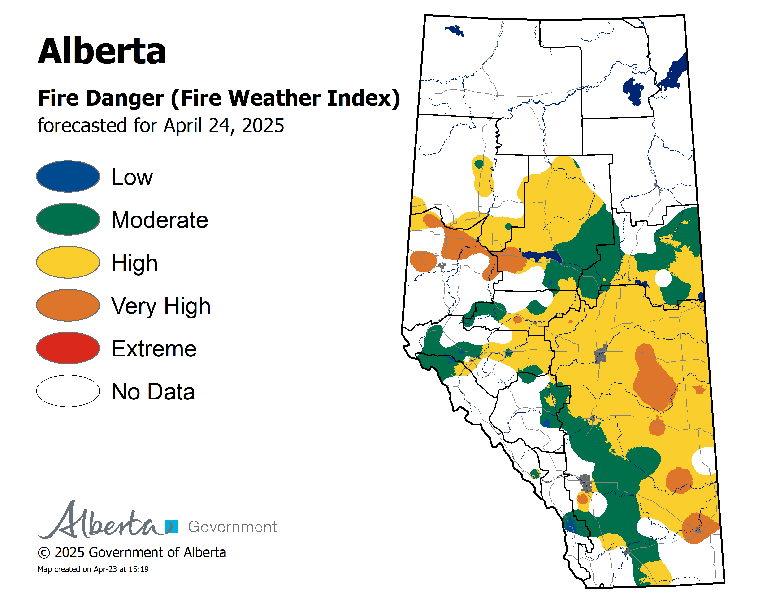
Wildfire Danger
The wildfire danger remains Extreme for areas north of Lesser Slave Lake, and Very High to High for areas south of Lesser Slave Lake.
Click here to view the wildfire danger map for today.
The Fire Ban and OHV Restriction remain in place for areas north of Lesser Slave Lake. To view a map and details regarding the Fire Ban/OHV restriction visit www.albertafirebans.ca
Wildfire Update
Since the start of the wildfire season on March 1st, there have been 102 wildfires and 264,767 hectares burned in the Slave Lake Forest Area.
New Wildfire Starts
There were no new wildfire starts yesterday.
SWF-102 is located 1.3 kilometres west of the Chip/Alpac Road at approximately kilometre 45. It started on June 9th. 23 firefighters, four helicopters and heavy equipment continue to fight this wildfire. It is 153 hectares in size and is classified as out of control.
Provincial Wildfire Situation
For information on the wildfire situation across the province of Alberta click here.
Click here to view a map of the wildfires burning in Alberta.
Alberta Emergency Management Agency issued Information Alert Update issued June 12th at 10:29 am
The evacuation orders for Wabasca-Desmarais, Hamlets of Sandy Lake, and Chipewyan Lake, and all of Bigstone Cree Nation have been rescinded and the public can now return back to these areas. Residents must be prepared to evacuate on short notice, due to wildfire activity in the area. Keep up to date by visiting www.emergencyalert.alberta.ca
A Wildfire Information station has been set up at the Visitor Information Centre in Wabasca Wednesday June 12th 8:00 am - 8:00 pm.
As of June 12th at 7:08 am Alberta Transportation has opened Highway 754 and Highway 813.Highway 813 from Wabasca to Sandy Lake is open. Highway 754 from Highway 88 to Wabasca is open. Expect delays due to traffic volume and reduced visibility in smoke.Speed reductions in effect. For the safety of our firefighters, please obey the reduced speed limit on the highways.View updates on highways by visiting 511.Alberta.ca or download the mobile app.
Smoky conditions are expected to continue in the Wabasca area.If you experience respiratory difficulties, visit Alberta Health Link or dial 811. Visit www.firesmoke.ca to view the most current smoke forecast.Click here to view the air quality statement that has been issued.Click here for Alberta Health Services Information about Wildfire Smoke.
Structure protection equipment remains in place. Cick here for a message from the Fire Chiefs of the Wabasca and Bigstone Cree Nation Fire Departments regarding the fire fighting equipment that has been left in place.
The Fire Ban and OHV Restriction remain in place for areas north of Lesser Slave Lake. To view a map and details regarding the Fire Ban/OHV restriction visit www.albertafirebans.ca
McMillan Wildfire Complex
The McMillan Wildfire Complex is comprised of five wildfires. Of the five wildfires, two are under control and three are classified as out of control. Firefighters declared SW-049 30 per cent contained on June 10th.
SWF-049 is 262,768 hectares and is classified as out of control.
SWF-078 is 137 hectares and is classified as under control.
SWF-079 is 994 hectares and is classified as out of control. This fire is located 9.4 kilometres to the northwest of Wabasca No. 166C.
SWF-090 is 215 hectares and is classified as out of control.
SWF-099 is 2 hectares and is classified as under control.
Today on SWF-049, firefighters will continue to establish pumps and hose on all sections of the fire and are extinguishing 30 metres into the fire.
Heavy equipment will continue construction of dozer lines in the south and west of the fire and are building helipads on the north side of the fire to improve firefighter and aircraft access to the fire.
Firefighters will be conducting an ignition operation in the northwest section of the fire to bring the fire to secure boundaries.
Airtankers and helicopters with buckets will be used when required.
Firefighters with helicopters continue fighting SWF-079.
Great progress continues to be made on SWF- 078 and SWF-099 as all of these fires are under control.
There are 542 firefighters and support staff, 44 helicopters, airtankers, and 43 pieces of heavy equipment fighting this wildfire.
Structure protection remains in place for the communities of Trout Lake, Wabasca, Bigstone Cree Nation and Marten Beach.
SWF049 remains approximately:
- 4.9 and 3.3 kilometres west of Wabasca No. 166B and 166D
- 26.5 kilometres northeast of Marten Beach
- 32.8 kilometres northeast of Slave Lake
- 9.3 kilometres southeast of Trout Lake
Click here to view a map with imagery and click here for one without imagery of the McMillan Wildfire Complex.
Weather
For Wednesday the temperature will be 24 to 26 degrees. Winds will be from the southwest/west 15-20 kilometres per hour. For areas north of Lesser Slave Lake there is a chance of thundershowers with lightning.

Leah Lovequist
Wildfire Information Officer
Mobile: 780-849-0945
Email:leah.lovequist@gov.ab.ca
Keep up to date on the wildfire situation by subscribing to the Slave Lake Forest Area Wildfire Update or download the free Alberta Wildfire app for Apple or Android devices.


