

We have firefighters in aircraft working on the out of control wildfires and fire lookouts watching for smoke. While we always appreciate people calling in to report wildfires, the large volume of calls we are currently receiving is diverting our resources away from fighting wildfires. As always, please still call 310-FIRE if you see smoke or flame that looks new and potentially unreported, but assume that large columns of smoke and burned over areas have already been detected and reported.
On Alert
DO NOT FLY DRONES NEAR WILDFIRES
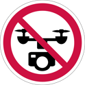
The use of recreational drones over wildfires in Alberta is dangerous, illegal and could result in a fine of up to $15,000* for putting aircraft and people at risk. Please give Alberta firefighters the space they need to do their jobs safely.
*according to Transport Canada
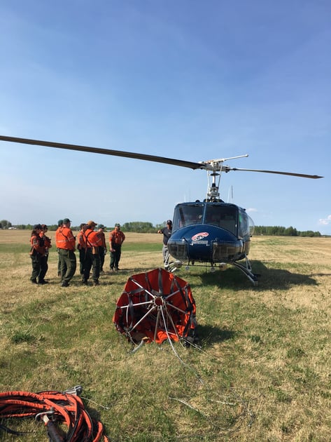
Ontario firefighters receiving helicopter safety briefing.
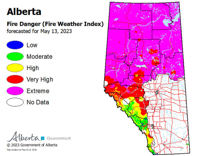
Wildfire Situation
Grizzly Complex – SWF057, SWF063, SWF064
As a result of the warm, dry conditions yesterday an increase in fire intensity was observed on the Grizzly Complex wildfires, although minimal growth was noted. This intensity is anticipated to increase in the upcoming days. Firefighters, aircraft and heavy equipment groups continue to build guards and address hot spots as they flare up. Updated wildfire perimeter mapping is also expected to be conducted today. There are 65 firefighters, seven heavy equipment groups and 12 helicopters working on these wildfires.
SWF-057 located approximately 26 kilometres south of Kinuso and over 30 kilometers southwest of the Town of Slave Lake is classified as out of control and has burned an estimated 8,337 hectares. Heavy equipment continues to build fire guard along the west to south side of the wildfire and firefighters continue to secure the guard by extinguishing the wildfire’s perimeter while helicopters are bucketing on flare ups. This guard is approximately 95% complete in this area and they are making steady progress. Firefighters are also working on the north side of the wildfire with helicopter bucket support. Smoke from this wildfire is expected to be visible from Highway 33 today.
SWF-063 is located approximately seven kilometers south of High Prairie is classified as burning out of control and has burned an estimated 69,074 hectares. Firefighters, helicopter bucket support and nodwells focused on the northwest portion of the fire, working in the East Prairie Metis Settlement and Banana Belt areas to address hotspots and flare ups as well as continuing to secure the perimeter in the area between High Prairie and East Prairie Metis Settlement. Heavy equipment continues to build fire guard around the northwest side of the wildfire, as well as near East Prairie River and helicopters continue to address hotspots with buckets.
SWF-064 is located over 40 kilometers south of the Town of High Prairie, is classified as out of control and has burned approximately 22,398 hectares. The heavy equipment group continues to build fire guard around the northwest portion of the wildfire.
To view wildfires on a map, download the AB Wildfire App or visit the Alberta Wildfire Status Dashboard
Nipisi Complex-SWF059,SWF060
As a result of the warm, dry conditions an increase in fire intensity was observed and some growth towards the north occurred on the Nipisi Complex wildfires. Firefighters, aircraft and heavy equipment groups continue to build guards and address hot spots as they flare up. There are 66 firefighters, four heavy equipment groups and 12 helicopters working on these wildfires.
SW060 located 2.3 kilometres east of the border of the Whitefish Lake First Nation is classified as burning out of control and has burned approximately 16,680 hectares. The southwest end of the wildfire closest to the Whitefish Lake First Nation Community border did not experience any increase in fire activity and firefighters have sprinkler lines set up along the community FireSmart fire guard located north of the community. Yesterday, the wildfire did experience some growth on the northeast side of the wildfire towards SWF059. Smoke was and will continue to be visible for the communities of Whitefish Lake First Nation and Trout Lake.
SWF059 located over 24 kilometres northeast of the White Fish Lake First Nation border is classified as burning out of control and has burned approximately 1,036 hectares. The wildfire was active on the northern side of the wildfire however the growth was not significant.
Wildfire operations for SWF068 located approximately nine kilometres northwest of Peavine Metis Settlement has been transferred over to the Peace River Forest Area. For information on this wildfire visit the Peace River Wildfire Update.
To view wildfires on a map, download the AB Wildfire App or visit the Alberta Wildfire Status Dashboard
Since January 1, 2023, in the Slave Lake Forest Area, there have been 75 wildfires which have burned 158,036.18 hectares.
Since January 1, 2023, in the Forest Protection Area of Alberta, there have been 443 wildfires which burned 448,649.36 hectares.
To view wildfires on a map, download the AB Wildfire App or visit the Alberta Wildfire Status Dashboard
Alberta Emergency Alert
A provincial state of emergency has been declared for Alberta. Critical alerts and advisories have been issued for communities around active wildfires. Visit http://www.alberta.ca/emergencyalert for details. Albertans who require assistance can also call 310-4455 for evacuation related information.
For the an accurate forecast of wildfire smoke, visit FIRESMOKE CANADA.
Volunteer Information
Volunteers, equipment owners/operators or firefighters looking to assist with these wildfires or any of the wildfires within the province, please contact EmergencySupportOffers@gov.ab.ca.
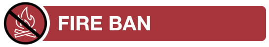
FIRE BAN AND OHV RESTRICTION IN EFFECT
A fire ban and off-highway vehicle restriction is in effect within the Forest Protection Area due to extreme fire danger.
Under this fire ban:
- All existing Fire Permits are suspended (or cancelled)
- No new Fire Permits will be issued
Prohibited:
- All outdoor wood fires are banned, including wood campfires on public lands, wood campfires on private land and provincial campgrounds
- Backyard firepits
- BBQ charcoal briquettes
- The use of fireworks and exploding targets
- The recreational use of off-highway vehicles (OHV) on public lands, including designated OHV trails
Allowed:
- Propane/natural gas-powered appliances
- Open flame oil devices (e.g., turkey deep fryers, tiki torches)
- Indoor wood fires contained within a device with a chimney and spark arrestor
- All appliances must be CSA approved and used per manufacturer’s standards
- Indigenous people when using an off-highway vehicle for traditional purposes. Traditional purposes are hunting, fishing, and trapping – including the use of an OHV to travel to the location(s) for these purposes.
- Essential industry-related activities requiring the use of OHVs.
- Off-highway vehicle use is still permitted on private lands.
The fire ban and ohv restriction will remain in effect until conditions improve. Firefighters thank you for your cooperation.
To view a map of the affected area visit www.albertafirebans.ca
If you have questions about the Fire Ban or OHV Restriction please call 1-866-394-3473.
.png?width=1200&name=wildfire%20app%20(2).png)
Wildfire Information
The wildfire dashboard provides up-to-date wildfire information at the click of a button. This interactive tool displays important statistics on the number of active wildfires in the province, sizes, locations, suspected causes and more. The dashboard builds on the former wildfire status map by displaying the most frequently accessed information in one convenient location.
Download the Alberta Wildfire app today and get access to accurate, real-time information on wildfires in your area. You can also find information on fire advisories, restrictions and bans across the province and much more all on your mobile device. Available for Apple and Android.
Subscribe to the Slave Lake Forest Area Wildfire Update to receive an email when new information is posted.
Join the conversation on Facebook, Twitter or Instagram. ![]()
![]()
![]()
Unless conditions change you can expect your next wildfire update on May 14, 2023.
If you have any questions please contact:
Leah Lovequist
Wildfire Information Officer
Mobile:780-849-0945
Email:leah.lovequist@gov.ab.ca
RELATED INFORMATION
Websites:
- Alberta Wildfire
- Alberta Fire Bans
- FireSmart in Alberta
- Alberta Emergency Alerts
- Air Quality Health Index
- Wildfire Smoke and Your Health
- 511 Road Reports
- Emergency Preparation
Social Media: