

FIRE BAN REMAINS IN EFFECT
 Due to the continued wildfire danger from dry grass and weather indicators, the Fire Ban and OHV Restriction remains in effect for the Peace River Forest Area and most of northern Alberta.
Existing fire permits are suspended until further notice.
Prohibited
- All open fires including campfires in campgrounds, backcountry and random camping areas and backyard fire pits.
- Charcoal briquettes, turkey fryers and tiki torches.
- Fireworks and exploding targets.
- The use of off-highway vehicles for recreational use on all public lands.
Allowed
- Portable propane fire pits that are CSA approved or UL certified.
- Gas or propane stoves and barbecues that are CSA approved or UL certified and are designed for cooking or heating.
- Catalytic or infrared-style heaters.
- OHVs for industrial use, agricultural use, and traditional use by Indigenous peoples, as well as use on private lands.
The Fire Ban and Off-Highway Vehicle Restriction will remain in effect until conditions improve.
Many nearby municipalities have advisories, restrictions or firebans in place. Please check www.albertafirebans.ca for more information and to view a map of the fireban/OHV restriction boundaries.
WILDFIRE UPDATE (current as of June 8, 2019 at 11 am)
Numerous resources including crews, aircraft and heavy equipment groups have been placed throughout the area on standby and at the ready to quickly action any new wildfire starts.
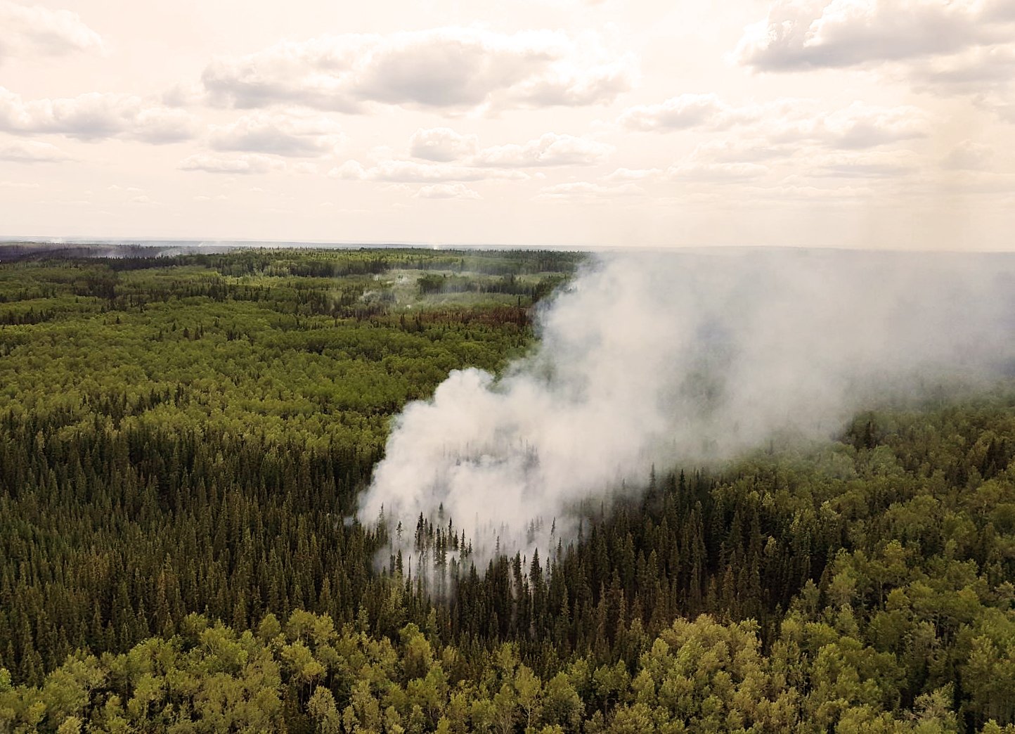
There have been 73 wildfires in the Peace River Forest Area this fire season, and each of these wildfires has now been extinguished with the exception of two.
WILDFIRES OF NOTE:
Battle Complex:
PCX-001 (formerly PWF 052 and 054) remains out of control at 56,200 hectares in size in the Manning/Notikewin area
-
Yesterday was a great work day for crews, with cooler temps and higher relative humidity levels helping to reduce fire behavior. Some spots are still flaring despite the cool temperatures. Crews have been actioning hot spots with the support of aerial resources, while the heavy equipment groups continue to build guard.
-
There are 408 personnel working on the fire today. Over the next few days personnel will be cycling out for days of rest, so numbers will drop before new crews are added to the incident. A fleet of 13 aircraft remains, as well as 73 pieces of heavy equipment.
PWF 070 remains classified as under control at 251 hectares in size west of Keg River. The fire has been completely surrounded by dozer guard and the perimeter has not changed since Monday of last week. Firefighters and aircraft are continuing to work towards extinguishing this fire and do not expect the perimeter to grow beyond the current boundaries.
HWF 042 (Chuckegg Creek Fire)
For updates on this fire, please visit http://srd.web.alberta.ca/high-level-area-update
For your safety and the safety of the numerous firefighters working to contain these wildfires, please stay obey the access restrictions and stay out of the area.
For information on the wildfire situation across the province of Alberta, visit: wildfire.alberta.ca.
FIRE WEATHER
Today’s forecast has maximum temperatures of 13 degrees, relative humidity levels of 40%, and winds from the NW at 15-20 km/hr. Some light rain may pass through the area. Conditions on the fire will include some isolated candling today. A drying trend will continue with gradual warming into Sunday.
SAFETY NOTICES
EVACUATION UPDATES
County of Northern Lights:
For more information on evacuation alerts, visit Alberta Emergency Alert or download the free Alberta Emergency Alert app.
ROAD CLOSURES
The Chinchaga Road continues to be closed to the public. It can be accessed by commercial traffic but there are danger trees along the route so those using the road must stop at the checkpoints, drive 50 km/hr and drive straight through. No stopping is permitted while traversing the fire area.
Highway 35 is now open. Travel between Township Road 1022 and 5km south of High Level requires a police escort. Expect major delays in the area. There still is no access to Paddle Prairie at this time due to the wildfire.
For information on road closures and other access related hazards, visit Alberta 511 or download the free Alberta 511 app.
SMOKE
Smoke may be drifting into the area for the foreseeable future. Anyone with health concerns should check with Alberta Health Services or call 811 for 24/7 health advice from Alberta Health Link. For a smoke forecast map, visit Wildfire Smoke Forecasts for Western Canada.
FIRE PERMITS SUSPENDED
All fire permits have been suspended, effective on May 16 at 6 pm. No fire permits will be issued until the fire danger conditions improve.
Please call the Peace River Forest Area office at 780-624-6190 if you have any questions about fire permits.
DO YOUR PART TO PREVENT WILDFIRES
Please continue to respect the fire ban and quad restriction currently in effect.
FIRESMART
You can protect your home from wildfire
Protecting your home from wildfire starts with simple actions. Whether you are doing regular yard maintenance or making large scale changes during renovations or landscaping, you can make choices that will help protect your home from wildfire.
Learn more at firesmartcanada.ca.
FOR MORE INFORMATION

- Bookmark the Peace River Wildfire Update and check for updates anytime or subscribe to have it emailed to you
- Download our app, available for Apple and Android devices.
- You can also find us on Facebook,Twitter, Youtube
- or visit www.wildfire.alberta.ca
Or contact:
Crystal Burrows
Wildfire Information Officer
(780) 618-6215
crystal.burrows@gov.ab.ca
Report Wildfires 310-FIRE (3743)