

Chuckegg and Jackpot Creek Wildfires Remain Out of Control.
Fire Ban and Off-Highway Vehicle Restriction Continues. The fire danger remains Extreme as the area needs a significant rainfall for the danger to be reduced. Report wildfires by calling 310-FIRE(3473).
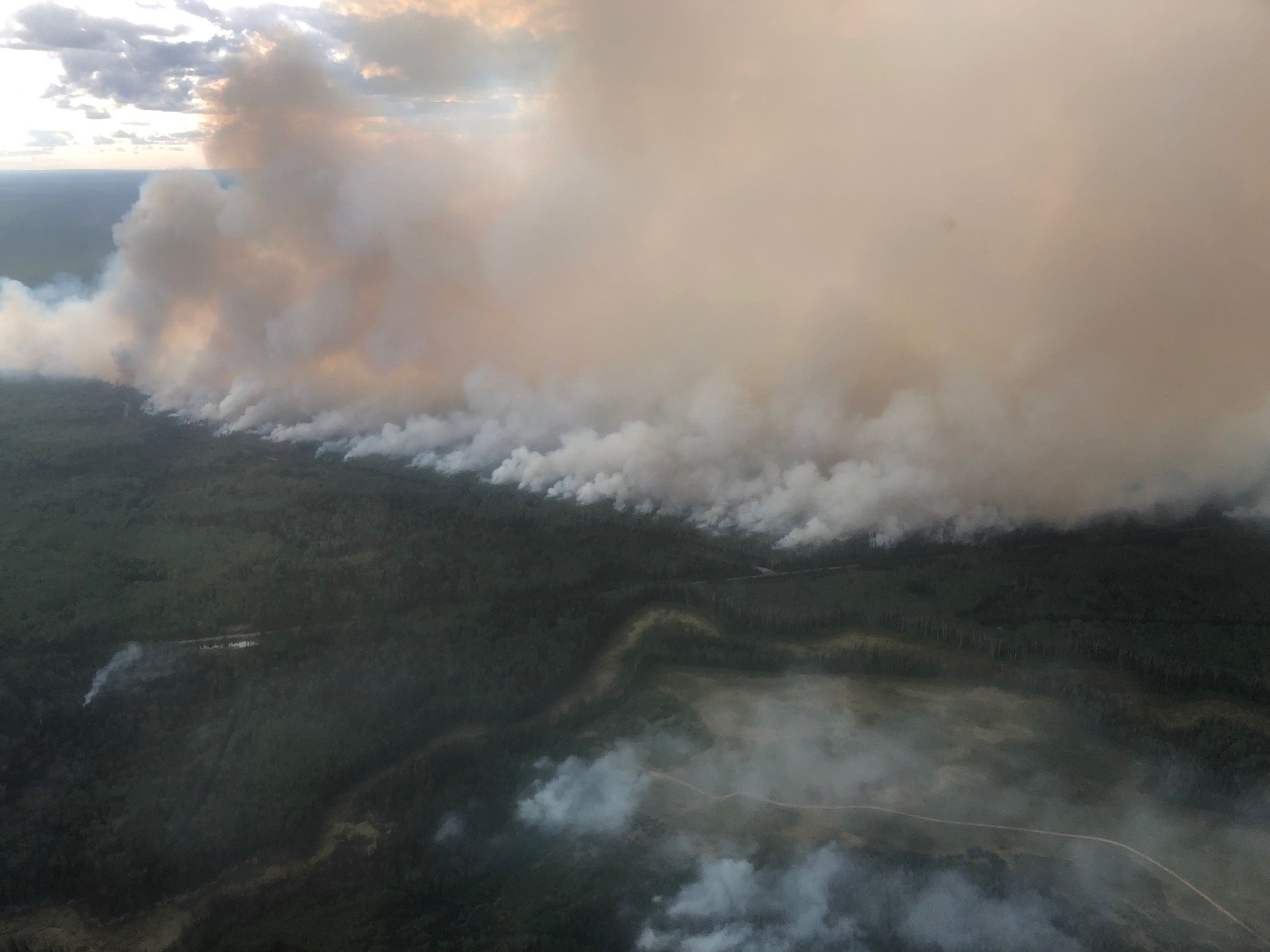
(Warmer temperatures, lower humidity and winds out of the southwest resulted in the Chuckegg Creek fire seeing an increase in activity on the west, south and east side, between the Boyer River and the Peace River)
HIGH LEVEL FOREST AREA | WILDFIRE UPDATE | JUNE 11, 2019 AT 8:30 P.M.
There are 3 active wildfires in the High Level Forest Area - Two are Out of Control (OC), and one is Being Held (BH).
- The Chuckegg Creek fire (HWF-042) remains Out of Control (OC) at 269, 648 hectares.
- The Jackpot Creek Wildfire (HWF-066) around Steen River remains Out of Control (OC) at 28, 100 hectares.
- Fire (HWF075), is located approximately 42 km southeast of South Tall Cree, east of highway 88. This fire is Being Held (BH) at 18 hectares. There are 16 firefighters with air support from 1 helicopters. There is no threat to any communities.
Click here for a map of all fire locations and statuses within the High Level Forest Area.
Firefighters, helicopters, airtankers and heavy equipment are positioned throughout the High Level Forest Area to respond to any new wildfire starts. Please report wildfires by calling 310-FIRE.
The next update will be at 11:00 A.M., or if conditions change.

FIRE BAN AND OFF-HIGHWAY VEHICLE RESTRICTION REMAIN IN EFFECT
A Fire Ban and Off-Highway Vehicle Restriction is in effect for the High Level Forest Area due to dry conditions and no significant rainfall in the forecast. The ban and restriction will remain in effect until conditions improve. All fire permits are suspended and no new fire permits will be issued.
Prohibited
- All open fires including campfires in campgrounds, backcountry and random camping areas and backyard fire pits.
- Charcoal briquettes, turkey fryers and tiki torches.
- Fireworks and exploding targets.
- The use of off-highway vehicles for recreational use on all public lands.
Allowed
- Portable propane fire pits that are CSA approved or UL certified.
- Gas or propane stoves and barbecues that are CSA approved or UL certified and are designed for cooking or heating.
- Catalytic or infrared-style heaters.
Visit albertafirebans.ca for more information or download the new Alberta Fire Bans mobile app.
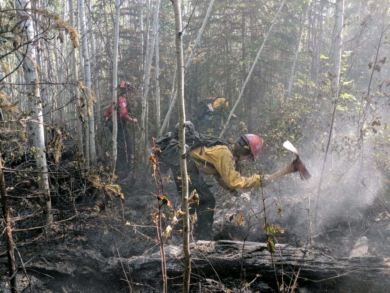
(Firefighters on the Chuckegg Creek fire use Pulaski's to dig up hotspots to limit fire spread and for creating fire breaks. Firefighters chop down trees with the axe side, cut away roots and shrubs with the end of the adze blade, and dig barriers with the wide portion of the adze)
THE CHUCKEGG CREEK FIRE | JUNE 11, 2019 AT 8:30 P.M.
Warmer temperatures, lower humidity and winds out of the southwest resulted in the fire seeing an increase in activity on the west, south and east side between the Boyer River and the Peace River. Firefighters along with air support from bucketing helicopters and airtankers continue to work in priority areas to limit fire spread.
Heavy equipment also continues to create guard in to limit spread and aid firefighters in accessing the fire perimeter. Firefighters along with bucketing helicopters continue to work around Paddle Prairie to extinguish hotspots to limit fire spread and protect values.
Firefighters continue to consolidate containment along Highways 35 and 58, and north of highway 58, west of High Level. Firefighters are continuing to gain access on the west side of the fire in priority areas where access is more remote.
- The last recorded size is approximately 269, 648 hectares.
- Alberta Wildfire has 687 firefighters and personnel. With 41 helicopters and 129 pieces of heavy equipment.

THE JACKPOT CREEK FIRE | JUNE 11, 2019 at 8:30 P.M.
Due to warmer temperatures, lower humidity and winds out of the southwest the fire saw activity predominately on the northeast side. Firefighters with the support from bucketing helicopters continue to limit spread in priority areas on the south side of the fire. Firefighters continue to utilize helipads to access new areas of the fire’s perimeter, using pumps and hose, hand tools and support from helicopter bucketing.
- The last updated size of the fire is approximately 28,100 hectares.
- There are 94 firefighters and 6 helicopters working on this fire.
ALERTS AND EVACUATIONS
PADDLE PRAIRIE METIS SETTLEMENT
Paddle Prairie has an evacuation order in place. Evacuees should register at the reception centre located at the Grande Prairie Regional College. The reception centre phone number is 780-567-5587. For information on the Paddle Prairie Metis Settlement evacuation, please visit their Facebook page.
TOWN OF HIGH LEVEL | MACKENZIE COUNTY | DENE THA
The eight-hour evacuation alert has been lifted for the Town of High Level and the Dene Tha’ First Nation community of Bushe River and for the Mackenzie County rural area immediately north and south of High Level.
The eight-hour evacuation alert will remain for the area west of Blues Creek and Blue Hills road (Range Road 180), north and south of Highway 697.
In areas still under eight-hour evacuation alert, this means residents should ensure they have a full tank of gas and supplies to last two to three days in case a mandatory evacuation becomes necessary.
All residents of the area should continue to check the following links and listen to local radio for updates.
- Alberta Emergency Alert, Download the mobile app.
- Town of High Level Website or Facebook page
- Mackenzie County Facebook Page
ALBERTA TRANSPORTATION
Alberta Transportation has reopened Highway 35 south of High Level with the aid of a police escort to ensure travelers safety, expect delays. Highway 697 east of Highway 35 to the La Crete Ferry remains closed. The La Crete Ferry is also closed. To stay informed on all road closure info visit the Alberta Transportation website or download the mobile app.
SMOKE ISSUES
Smoke from wildfires in northern Alberta has caused poor air quality and reducing visibility at times. Winds will continue to shift bringing smoky conditions. For health related smoke issues, please visit Alberta Health Services.

Victoria Ostendorf | Wildfire Information Officer
Mobile: 780-841-9387
1-866-FYI-FIRE
RELATED INFORMATION
- Alberta Wildfire Status
- Alberta Fire Bans
- Air Quality Health Index
- Alberta Emergency Alerts
- 511 Road Reports
- Emergency Preparation