

Chuckegg and Jackpot Creek Wildfires Remain Out of Control.
Fire Ban and Off-Highway Vehicle Restriction Continues. The fire danger remains Extreme as the area needs a significant rainfall for the danger to be reduced. Report wildfire by calling 310-FIRE(3473).
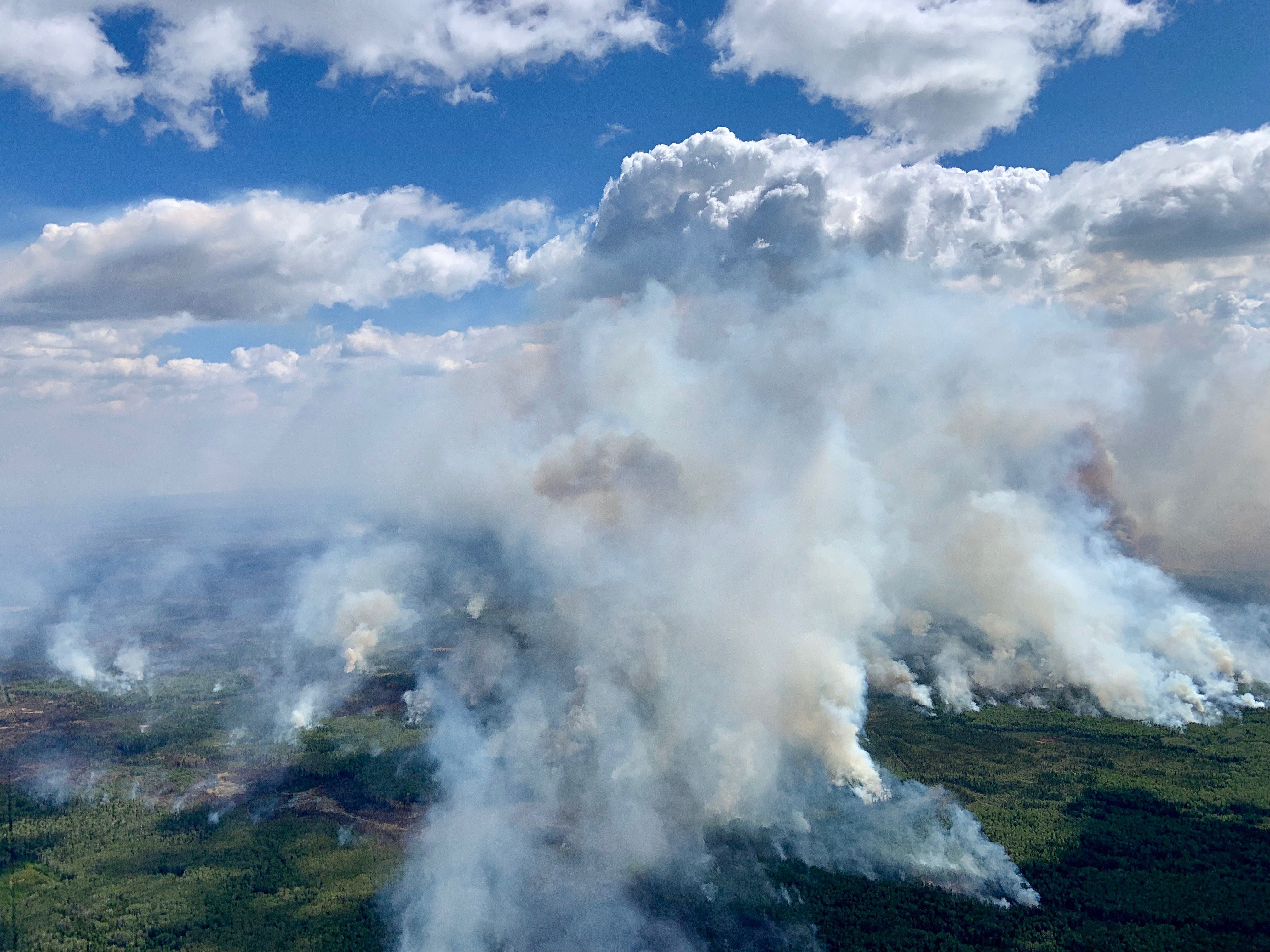
(Due to no significant rainfall and warmer temperatures returning the Chuckegg Creek fire experienced an increase in fire activity on the west, southwest, south and east side of the fire, north of the Peace River.)
HIGH LEVEL FOREST AREA | WILDFIRE UPDATE | JUNE 9, 2019 AT 8:30 P.M.
There are 4 active wildfires in the High Level Forest Area - Three are Out of Control (OC), and one is Under Control (UC).
- The Chuckegg Creek fire (HWF-042) remains Out of Control (OC) at 265, 925 hectares.
- The Jackpot Creek Wildfire (HWF-066) around Steen River remains Out of Control (OC) at 28, 167 hectares.
- Fire (HWF075), is located approximately 42 km southeast of South Tall Cree, east of highway 88. This fire is Out of Control (OC) at 6 hectares. There are 22 firefighters with air support from 3 helicopters and airtankers. This fire spread in a east direction today as winds were out of the west in that area. There is no threat to any communities.
Click here for a map of all fire locations and statuses within the High Level Forest Area.
Firefighters, helicopters, airtankers and heavy equipment are positioned throughout the High Level Forest Area to respond to any new wildfire starts. Please report wildfires by calling 310-FIRE.
The next update will be at 11:00 A.M., or if conditions change.

FIRE BAN AND OFF-HIGHWAY VEHICLE RESTRICTION REMAIN IN EFFECT
A Fire Ban and Off-Highway Vehicle Restriction is in effect for the High Level Forest Area due to dry conditions and no significant rainfall in the forecast. The ban and restriction will remain in effect until conditions improve. All fire permits are suspended and no new fire permits will be issued.
Prohibited
- All open fires including campfires in campgrounds, backcountry and random camping areas and backyard fire pits.
- Charcoal briquettes, turkey fryers and tiki torches.
- Fireworks and exploding targets.
- The use of off-highway vehicles for recreational use on all public lands.
Allowed
- Portable propane fire pits that are CSA approved or UL certified.
- Gas or propane stoves and barbecues that are CSA approved or UL certified and are designed for cooking or heating.
- Catalytic or infrared-style heaters.
Visit albertafirebans.ca for more information or download the new Alberta Fire Bans mobile app.
THE CHUCKEGG CREEK FIRE | JUNE 9, 2019 AT 8:30 P.M.
Due to no significant rainfall and gusty winds out of the northwest shifting to the southwest the fire experienced an increase in fire activity on the west, southwest, south and east side, north of the Peace River. Firefighters carried out a successful controlled burn operation on the west, and southwest side of the fire, today as conditions allowed to do so. Bucketing helicopters and airtankers continue to assist firefighters on the ground.
Firefighters continue to work around Paddle Prairie to extinguish hotspots and are utilizing infrared scans to assist with identifying priority areas. Firefighters are also continuing to cut heli pads on the west side of the fire to gain access in priority areas. Heavy equipment continues to create guard in priority areas to limit spread and aid firefighters in accessing the fire perimeter.
- The last recorded size is approximately 265, 925 hectares.
- Firefighters continue to consolidate containment along Highways 35 and 58, and north of highway 58 west of High Level.
- Alberta Wildfire has 757 firefighters and personnel. With 42 helicopters and 135 pieces of heavy equipment.
- Atco is continues to repair power poles along highway 35 south of High Level. Atco has restored power supply and is supporting normal operations to the Town of High Level, La Crete, Fort Vermilion & Dene Tha’ First Nation. Atco has secured large-scale backup generators that can be drawn on to provide power to communities, if needed.

THE JACKPOT CREEK FIRE | JUNE 9, 2019 at 8:30 P.M.
With scattered showers affecting some sections of the fire, firefighters continue to make excellent progress again today. Newly constructed helipads enabled firefighters to focus on the west side of the southern area of the fire, building control lines along the perimeter.
On the west, firefighters were able to make headway eastward towards the center portion of the fire’s perimeter as well as towards the north on the west side of the fire. Firefighters continue to establish control lines as they work to impede the fire’s spread to the south and west. Early morning infrared scanning will helped identify new targets in priority sections of this fire today.
- The last updated size of the fire is approximately 28,167 hectares.
- Assigned to the fire are 9 helicopters and 90 firefighters.
TOWN OF HIGH LEVEL | UPDATE
As of June 3, 2019 at 10:00 a.m., the mandatory evacuation order for the Town of High Level was lifted and an evacuation alert was put in place immediately. For more information please continue to monitor the Town of High Level Website at www.highlevel.ca, call 780-926-2201 (Monitored from 8am-10pm) or visit Alberta Emergency Alert for more updates.
MACKENZIE COUNTY | UPDATE
The eight-hour evacuation alert has been reduced to the area west of Blues Creek and Blue Hills road (Range Road 180), north and south of Highway 697. The La Crete Ferry Campground will remain closed until further notice.
An eight-hour evacuation alert remains in effect for the Town of High Level and the Dene Tha’ First Nation community of Bushe River. Parts of Mackenzie County immediately north and south of High Level will also remain under eight-hour evacuation alert, along with a portion of the Blue Hills/Tompkins area.
The Mackenzie County Incident Command Centre is open at the Fort Vermilion County office (4511-46 Avenue) or call (780) 927-3718 during regular office hours (8:15 a.m. – 4:30 p.m.). For all public notifications, please follow the Mackenzie County Facebook page.
PADDLE PRAIRIE METIS SETTLEMENT | UPDATE
Paddle Prairie has an evacuation order in place. The reception centre phone number is 780-567-5587. For information on the Paddle Prairie Metis Settlement evacuation, please visit their Facebook page.
ALBERTA TRANSPORTATION
Alberta Transportation has reopened Highway 35 south of High Level with the aid of a police escort to ensure travelers safety, expect delays. Highway 697 east of Highway 35 to the La Crete Ferry remains closed. The La Crete Ferry is also closed. To stay informed on all road closure info visit the Alberta Transportation website or download the mobile app.
SMOKE ISSUES
Smoke from wildfires in northern Alberta has caused poor air quality and reducing visibility at times. Winds will continue to shift bringing with it smoky conditions. For health related smoke issues, please visit Alberta Health Services.

Victoria Ostendorf | Wildfire Information Officer
Mobile: 780-841-9387
RELATED INFORMATION