

The Chuckegg and Jackpot Creek Wildfires Remain Out of Control
Fire Ban and Off-Highway Vehicle Restriction Continues
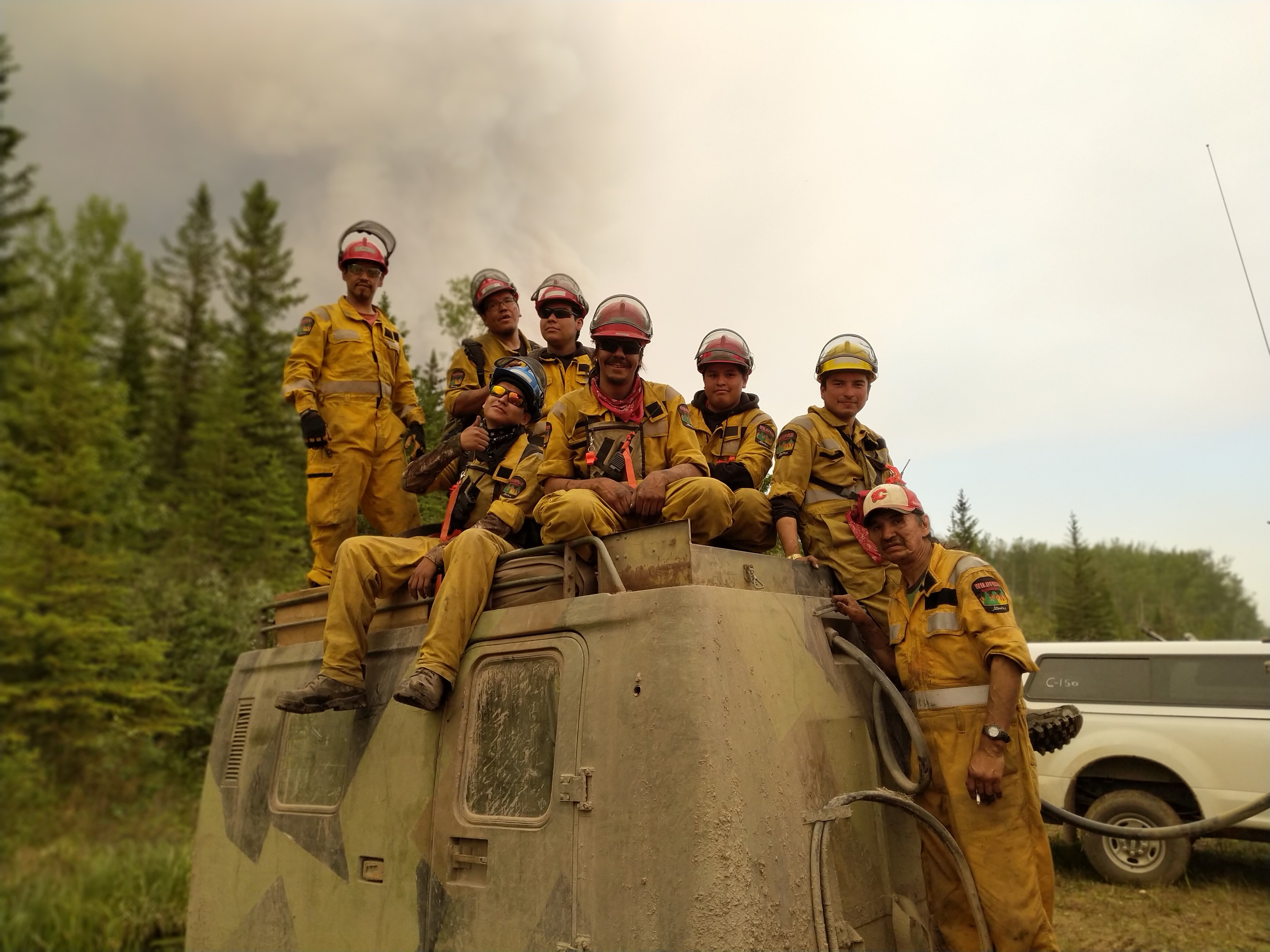
A wildfire crew (HSF19) takes a brief moment once their gear is loaded into the Haaglund to take a photo on Chuckegg Creek Fire.
Click here for a map of all fire locations and their status within the High Level Forest Area.
Firefighters, helicopters, airtankers and heavy equipment are positioned throughout the High Level Forest Area to respond to any new wildfire starts. Please report wildfires by calling 310-FIRE.
THE CHUCKEGG CREEK FIRE | June 18, 2019 12:30 p.m
An evacuation alert is in place for everyone in Rocky Lane and High Level north of the Peace River, west of RR 150 south of Hwy 58, the Town of High Level, south and southeast of the Town including the Dene Tha First Nations, Bushe River Reserve, and Beaver First Nations Child Lake Reserve. Additionally, all residents located in the Blue Hills area north of TWP Road 1010, west of RR 150, south of the Peace River including the Hamlet of La Crete.
Please check with the County or the Town or your local community to see if this alert upgrades to an evacuation order in the coming hours.
The Chuckegg Creek wildfire is now just under 324,209 hectares. The fire moved about 15 km in total yesterday. A current map is attached.
Winds kept the fire active overnight however the fire did not reach Devil Lake and it did not reach the Peace River. The fire is about 10 km north of the Boyer River cell tower and about 10 km west of the Peace River in a line directly west of La Crete. There was minimal growth on other areas of the fire overnight. Reports of spot fires outside the fire perimeter in the Blue Hills area are incorrect. Although there is a lot of smoke in this area, windrows and other burning trees are well within the fire perimeter.
Visibility on the east side of the fire is limited this morning however we have crews on the ground and heavy equipment deployment and structure protection assessment are underway in the Le Crete area as well as areas south of High Level.
Crews will continue to secure the north perimeter today. Crews on the west side will be watching for prime opportunities under west winds today to conduct ignition operations to clean up the perimeter and remove vegetation along control lines.
We continue to mop up hotspots along the south side of the fire in anticipation of residents returning to Paddle Prairie. Heavy equipment continues to work to strengthen the control line that ties in to Chain Ponds to further protect the south side from growth from NW winds.
The forecast for today is for a high of 21 degrees, 40% humidity, and winds W25 gusting to 45 km/hr. There is a slight chance of rain this afternoon, however it is going to take substantial rain (more than 20 ml) to make even a slight difference to fire intensity. These are the driest conditions this area has seen in more than 40 years. The winds will be the factor this afternoon and we expect the fire to travel eastward with significant risk of spotting in the gusty winds.
This fire has 890 firefighters and personnel, 46 helicopters and 153 pieces of heavy equipment working on this wildfire.
Be prepared. Stay informed.

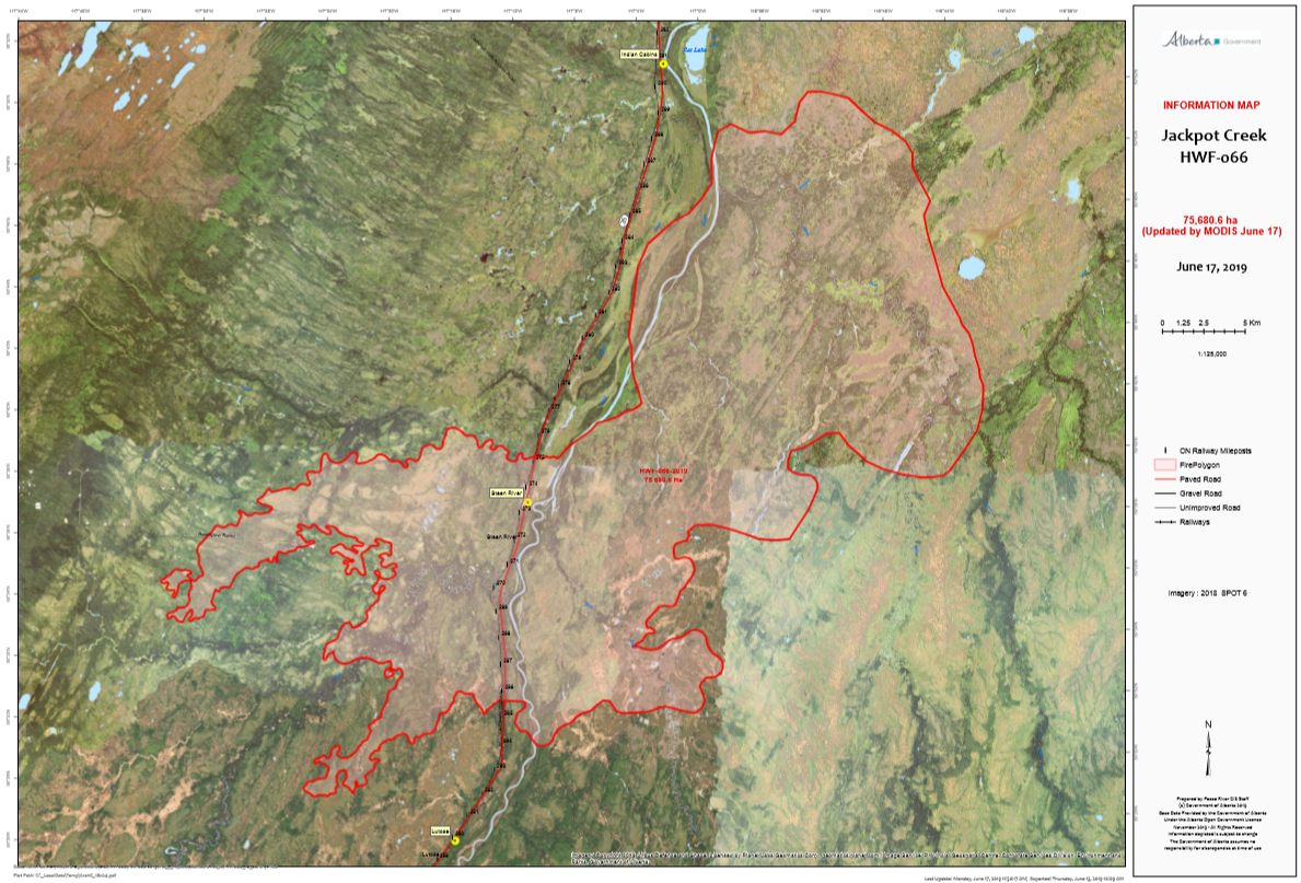
THE JACKPOT CREEK FIRE | June 18, 2019 12:30 p.m
Due to heavy smoke this morning, firefighters have not been able to fly the north boundary to give further updates.
As of yesterday, the southern perimeter west of the highway is holding well and crews are pushing further into the interior. On the southern side, east of the highway, dozers have reached the perimeter and have started establishing dozer guard. Fireguard continues to be built up the west side of the northern excursion on the east side of the Hay river. New fireguard is being established in the north to tie off from the highway to the Hay river. Highway remains open. Indian Cabins is evacuated but has not yet been impacted by the fire
- There are 116 firefighters and support staff, 11 helicopters and 2 pieces of heavy equipment working on this fire
- The last recorded size is 75,680 hectares.
FIRE BAN AND OFF-HIGHWAY VEHICLE RESTRICTION REMAIN IN EFFECT

A Fire Ban and Off-Highway Vehicle Restriction is in effect for the High Level Forest Area due to dry conditions and no significant rainfall in the forecast. The ban and restriction will remain in effect until conditions improve. All fire permits are suspended and no new fire permits will be issued.
Prohibited
- All open fires including campfires in campgrounds, backcountry and random camping areas and backyard fire pits.
- Charcoal briquettes, turkey fryers and tiki torches.
- Fireworks and exploding targets.
- The use of off-highway vehicles for recreational use on all public lands.
Allowed
- Portable propane fire pits that are CSA approved or UL certified.
- Gas or propane stoves and barbecues that are CSA approved or UL certified and are designed for cooking or heating.
- Catalytic or infrared-style heaters.
Visit albertafirebans.ca for more information or download the new Alberta Fire Bans mobile app.
ALERTS AND EVACUATIONS
TOWN OF HIGH LEVEL
For more information, please visit the Town of High Level Facebook page.
PADDLE PRAIRIE METIS SETTLEMENT
For information on the Paddle Prairie Metis Settlement evacuation, please visit their Facebook page.
MACKENZIE COUNTY
More information is also available at www.facebook.com/Mackenzie-County-262409787134568/ for Mackenzie County residents.
- Alberta Emergency Alert, Download the mobile app.
To stay informed on all road closure info visit the Alberta Transportation website or download the mobile app.
SMOKE ISSUES
Smoke from wildfires in northern Alberta has caused poor air quality and reducing visibility at times. Winds will continue to shift bringing smoky conditions. For health related smoke issues, please visit Alberta Health Services.

Leslie Lozinski | Wildfire Information Officer | Chuckegg Creek
Mobile: 780-623-9758
1-866-FYI-FIRE
Stephanie Grocholski | Wildfire Information Officer | High Level Forest Area
Mobile: 780-926-7509
1-866-FYI-FIRE
stephanie.grocholski@gov.ab.ca
RELATED INFORMATION
- Alberta Wildfire Status
- Alberta Fire Bans
- Air Quality Health Index
- Alberta Emergency Alerts
- 511 Road Reports
- Emergency Preparation